SnowenOutThere
-
Posts
5,616 -
Joined
-
Last visited
Content Type
Profiles
Blogs
Forums
American Weather
Media Demo
Store
Gallery
Everything posted by SnowenOutThere
-

2026 Mid-Atlantic Severe Storm General Discussion
SnowenOutThere replied to Kmlwx's topic in Mid Atlantic
Cell south of dc has a weak mesocyclone -
2026 Mid-Atlantic Severe Storm General Discussion
SnowenOutThere replied to Kmlwx's topic in Mid Atlantic
Debating if I want to drive out on a local chase. Would set up east of Culpepper. -
2026 Mid-Atlantic Severe Storm General Discussion
SnowenOutThere replied to Kmlwx's topic in Mid Atlantic
I’m sorta feeling today. At the bare minimum we’re over 1000 SCAPE right now so I think we will at least get some storms this evening. -
Wet late Monday 6/22 or another Fizzle?
SnowenOutThere replied to Weather Will's topic in Mid Atlantic
Shear looks better than forecasted last night. Surface winds are nearly due south instead of the more westerly direction shown by the models. -
Wet late Monday 6/22 or another Fizzle?
SnowenOutThere replied to Weather Will's topic in Mid Atlantic
3k NAM looked better too. Though severe wise the hodographs look less impressive than this morning. Generally the surface winds are more westerly instead of southern on the latest runs so you don’t get the same amount of directional shear -
2026 Mid-Atlantic Severe Storm General Discussion
SnowenOutThere replied to Kmlwx's topic in Mid Atlantic
It mixes tomorrow into the upper 50s for dewpoints, NAM stays in the mid to upper 60s. -
2026 Mid-Atlantic Severe Storm General Discussion
SnowenOutThere replied to Kmlwx's topic in Mid Atlantic
Its the RRFS but man those are some nasty updraft helicity tracks. Most I've seen for this area on any model. -
Beautiful sunset! NAM sounding expertly shows the distribution of the mid/high level clouds needed to make this sunset work
-
Hyped to coach a rain practice today, I always loved them when I swam outside.
-
Went on a morning hike of Harper’s Ferry MD side. Beautiful, got there at 6:30am and avoided the crowds.
-
2026 Mid-Atlantic Severe Storm General Discussion
SnowenOutThere replied to Kmlwx's topic in Mid Atlantic
Hell of a Tornado outbreak looks to be occurring in PA. 7 active warnings right now- 1,010 replies
-
- 1
-

-
- severe
- thunderstorms
- (and 7 more)
-
Stormy, sometimes you really need to realize you’re not the expert in the room. The SPC/drought monitor people/WPC all are smarter than you in their subject matter. So much ignorance of people about how much skill it takes to be an expert in a field. It’s a plague onto our society. From vaccine “skeptics” who believe they know better, to election deniers “who know the truth, to you sitting here spouting the same rhetoric. Listen more, post less.
-
2026 Mid-Atlantic Severe Storm General Discussion
SnowenOutThere replied to Kmlwx's topic in Mid Atlantic
Thanks for responding/correcting me. I suppose my main take was based on assuming the storm initiation method would be the same. To my knowledge Friday and Thursday had storms due to the Lee trough and intense heating generating cape and basically hitting convective temp around 3pm. I didn’t realize today was more synoptic based for storm development. I suppose I haven’t had practice with these yet. Though, I never thought that if storms popped they wouldn’t be nasty with the increased, especially considering WxUSF mentioning we are now 2000+ CAPE. -
2026 Mid-Atlantic Severe Storm General Discussion
SnowenOutThere replied to Kmlwx's topic in Mid Atlantic
You got a link to that? Preferably the height temp dep point sheet. I still have some full page skew-T sheets I took from my lab at UVA and would love to do a hand written analysis -
2026 Mid-Atlantic Severe Storm General Discussion
SnowenOutThere replied to Kmlwx's topic in Mid Atlantic
Hmm, took a look at the mesoanalysis page and I’m still on the train of storms today could be nasty, but I have some concerns about initiation. I did a hand analysis of the SPC page and evidently the pre frontal axis is located along route 15. Meanwhile, the pre frontal trough associated with a low level wind shift from south to south west is draped across the Allegheny front. I’m just not sure we have the juice to kick off storms. My dew point is in the upper 60s, but our cape west of the beltway remains stubbornly in the 500-1000 range. This isn’t like last Friday where we had 3000+ Cape and near conditionally unstable LL lapse rates. Additionally, the RH between the LCL and LFC is 30-50% across where the trough would cause storms to form. Just seems we got a good bit stacked against us thermodynamically. That said, this is all beginner analysis so the Mets probably see reasons that storms will pop that I don’t.- 1,010 replies
-
- 1
-
-
- severe
- thunderstorms
- (and 7 more)
-
2026 Mid-Atlantic Severe Storm General Discussion
SnowenOutThere replied to Kmlwx's topic in Mid Atlantic
Interesting how tight the gradient is between Louden county and the DC border. Do you think it’ll fill in west or no? Visual sat shows some clearing. -
2026 Mid-Atlantic Severe Storm General Discussion
SnowenOutThere replied to Kmlwx's topic in Mid Atlantic
If we get a bit more clearing then I’m feeling it today. Last week I got back to back days of legit severe storms. One of which was stronger than anything in the past couple years. Something to remember from both days is some CAMs were anemic the day of, so I’m not too worried about them. Additionally, both days last week produced that in spite of no shear. -
Cross posting here since it concerns some none severe weather


-
2026 Mid-Atlantic Severe Storm General Discussion
SnowenOutThere replied to Kmlwx's topic in Mid Atlantic
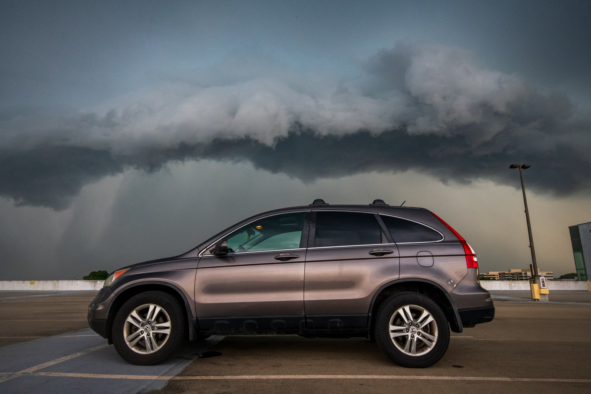
An exciting couple of hours weather wise! Honestly, once the first round passed I assumed it was over until I heard some thunder in the distance. After looking at the radar I instantly rushed off to the Herndon metro parking garage as it has the best skyline I know of. Got there in time to watch the shelf cloud develop and then roll in. Before becoming part of the "# of people struck by lightning a year" statistic I made sure to get a picture of my trusty stead: The humble CRV. Afterwards, I decided to ride out the storm inside of the parking garage as driving home on FFX County parkway did not seem like a good time. Eventually, I decided to take a video of the storm coming in. Could hear the metal signs clanging throughout the empty garage. Was pretty freaky. Finally, as the storm passed I saw a double rainbow appear. I attempted to get a lightning rainbow picture to complete my collection but had no such luck; though I personally hold the mental image with me. Lo and behold, just as I was packing up, another rainbow appeared which was even more vibrant than the first! Finally, I headed on homeward where I was met with a tree in the road. Additional limbs came down on fences, and even my neighbors windshield. Now, this (if I was smart) is where I should've realized that we will have an awesome sunset due to the past convection and humid air combined with the advantageous June sun angle and thus rushed to some open space to capture what might be the sunset of the year. Sadly, I only realized it was occurring as it passed (I'm sure there is a lesson in this) and realized a 10 minute drive would reward me only with deepening twilight. So, I sat back and watched what I could from my driveway.
- 1,010 replies
-
- 15
-
-
- severe
- thunderstorms
- (and 7 more)
-
Sunset of the year contender
-
2026 Mid-Atlantic Severe Storm General Discussion
SnowenOutThere replied to Kmlwx's topic in Mid Atlantic
Geez, got back home and there’s a tree down across the road. Couple limbs down around the neighborhood. Everyone’s outside.- 1,010 replies
-
- 2
-
-

-
- severe
- thunderstorms
- (and 7 more)
-
2026 Mid-Atlantic Severe Storm General Discussion
SnowenOutThere replied to Kmlwx's topic in Mid Atlantic
Just got to watch two separate double rainbows play out. Sadly didn’t get lucky with a lightning shot.- 1,010 replies
-
- 1
-
-
- severe
- thunderstorms
- (and 7 more)
-
2026 Mid-Atlantic Severe Storm General Discussion
SnowenOutThere replied to Kmlwx's topic in Mid Atlantic
Thanks for checking in! Went up to the Herndon metro parking garage for this one. Got some super neat storm pics as the shelf cloud formed in front of me. Realized it would be nasty checking velocity so I stayed in the garage and recorded a video of it hitting (will be posted later). Could hear the metal signs clanging. Didn’t seem to get the insane winds of IAD but I’m okay with that.- 1,010 replies
-
- 3
-
-
- severe
- thunderstorms
- (and 7 more)
-
2026 Mid-Atlantic Severe Storm General Discussion
SnowenOutThere replied to Kmlwx's topic in Mid Atlantic
Quick question for the meteorologists, but after this round initiates will there be back built development? In charge of practice and trying to figure out if I should cancel for the whole day (till 6:15) -
2026 Mid-Atlantic Severe Storm General Discussion
SnowenOutThere replied to Kmlwx's topic in Mid Atlantic
Noticing a tall CU cloud shooting up near Dulles. Seems to have hit the LFC and keeps rising.- 1,010 replies
-
- 1
-

-
- severe
- thunderstorms
- (and 7 more)