-
Posts
5,472 -
Joined
-
Last visited
Content Type
Profiles
Blogs
Forums
American Weather
Media Demo
Store
Gallery
Everything posted by SnowenOutThere
-
Went for a walk this morning through the forested areas of my neighborhood along creeks. Despite yesterday they were almost just as dry, but at least the pools had some flow between them!
-
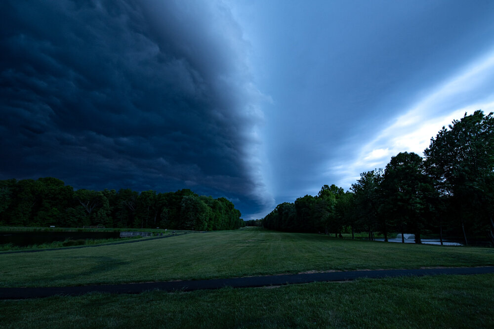
Had a nice shelf cloud come through as I drove home. Made a pit stop by a lake to get some shots, but wish I managed to get to the Herndon metro parking lot roof to see the oranges/purples of the rain behind them. Surrounding area got 0.4-0.5 inches of rain which is the most we've gotten in a long time. Felt good to finally hear heavy rain again.
- 270 replies
-
- 17
-

-

-
I don’t know if it can. Our Cape values are 250ish compared to WV 500-1000.
-
The radar right now reminds me of the January 3rd storm from 2022 with a front shutting off moisture flow to the north.
-
Man that's a weird temperature distribution. Seems like you have a pretty scattered low level inversion considering the valleys are colder than the mountains?
-
.08; missed the good stuff by a couple miles to the north.
-

2026 Mid-Atlantic Severe Storm General Discussion
SnowenOutThere replied to Kmlwx's topic in Mid Atlantic
Thanks for the confirmation, I’m just spitballing in these threads after seeing the mesoanalysis page so it’s nice to hear I’m on the right track. Quick question but what is downdraft cape in relation to cape itself? Seems a bit like an oxymoron from the name itself.- 330 replies
-
- severe
- thunderstorms
-
(and 7 more)
Tagged with:
-

2026 Mid-Atlantic Severe Storm General Discussion
SnowenOutThere replied to Kmlwx's topic in Mid Atlantic
We have decent mid level lapse rates (6.5), strong heating (8.5 low level lapse rates already), and strong increase of wind speed with height. Just don’t have any moisture! In the past I didn’t realize how much it mattered but after taking my courses this year at college the other half of cape is moisture availability. If only we had some higher humidity to generate cape today could’ve been a good severe weather squall line. Either way, if we get some added forcing we still could see a decent squall somewhere (maybe even relatively low precipitation so structure is more apparent?)- 330 replies
-
- severe
- thunderstorms
-
(and 7 more)
Tagged with:
-
It’s weird we can’t seem to buy even one nor easter or soaking rain event. Just constant weak NS waves. Honestly, it sorta feels like a winter pattern that just kept on lasting. Don’t know how we break out of it
-

2026 Mid-Atlantic Severe Storm General Discussion
SnowenOutThere replied to Kmlwx's topic in Mid Atlantic
Hazardous weather outlook for some possible tstorms today. Discussion says that it’s meager unless we get some instability. That said, we seem to get at least an hour or so of clear skies for a bit this morning, but dunno if that’ll do anything. Actually, how much heating/clearing time wise is needed to “destabilize” the atmosphere?- 330 replies
-
- severe
- thunderstorms
-
(and 7 more)
Tagged with:
-

2026 Mid-Atlantic Severe Storm General Discussion
SnowenOutThere replied to Kmlwx's topic in Mid Atlantic
Huh, there’s clearing out near 1-81 and even in Reston (I’m back from uva for the summer) there was a peak of filtered sunshine. Seems we may be ahead of schedule.- 330 replies
-
- severe
- thunderstorms
-
(and 7 more)
Tagged with:
-

2026 Mid-Atlantic Severe Storm General Discussion
SnowenOutThere replied to Kmlwx's topic in Mid Atlantic
From LWX: Honestly a bit surprised tomorrow got such a long writeup but the increasing risk of storms became high enough to rule out a hike in Shenandoah tomorrow. Recent guidance has trended a bit slower with the front`s progression through the area, which could potentially allow for a bit more destabilization tomorrow afternoon. As a result, the trend has also been slightly upward with CAPE values. Much of the destabilization appears to occur as a result of low-level moisture convergence in the vicinity of the surface front, which causes dewpoints to rise into the low to mid 60s. That being said, there is still a fair amount of uncertainty with respect to how much destabilization occurs, and also the areal coverage of storms that form. Shear certainly won`t be lacking tomorrow, with most soundings showing long, straight hodographs, with around 60 knots of effective bulk shear and over 100 knots of shear in the cloud bearing layer. So, if storms form, there is a conditional threat for supercells. The 12z HRRR for example, hinted at this possibility, with weak UH tracks. The thermodynamic environment is a bit odd, and casts uncertainty with respect to what hazards storms could potentially produce, if they occur at all. Model soundings show long, straight hodographs, which would normally be supportive of hail production. However, profiles are nearly saturated and moist-adiabatic at low-levels, with a considerable amount of the CAPE below the freezing level, which is unfavorable for hail production. Winds in the mid-upper levels are very strong, but aren`t overly impressive just above the surface. And model soundings show a good amount of dry air in the mid-levels (which yields DCAPE values around 700 J/kg), but very moist air at low-levels and poor low-level lapse rates, which would be unfavorable for transporting higher momentum air down from aloft. Machine learning guidance is downplaying the potential for severe thunderstorms, and SPC currently has us outlooked in general thunder. However, tomorrow is at least worth monitoring from a severe thunderstorm perspective given the CAPE/shear combination that could potentially be in place (high end scenario of around 1000 J/kg of MLCAPE, and 60 knots of effective bulk shear).- 330 replies
-
- 1
-

-
- severe
- thunderstorms
-
(and 7 more)
Tagged with:
-
Would the mountains in WV get crushed with the storm track or is it even warm at 4000ft?
-
NGL if the models still support some snow falling in WV I'll be taking a nice hike out there
-

2026 Mid-Atlantic Severe Storm General Discussion
SnowenOutThere replied to Kmlwx's topic in Mid Atlantic
Those same cells (weakening ofc as they move out of the best thermodynamic environment into the wedge) are approaching UVA and Tech (though further SW like Tech got clearing and now has 1000+ SBCAPE) so will be interesting to see if they can at least hold together enough/become elevated and drop good rain and thunder. Charlottesville itself has gotten split the whole past week and needs a good downpour.- 330 replies
-
- severe
- thunderstorms
-
(and 7 more)
Tagged with:
-

2026 Mid-Atlantic Severe Storm General Discussion
SnowenOutThere replied to Kmlwx's topic in Mid Atlantic
My point is this storm deserved a Tornado warning at some point in its lifespan.- 330 replies
-
- 1
-

-
- severe
- thunderstorms
-
(and 7 more)
Tagged with:
-

2026 Mid-Atlantic Severe Storm General Discussion
SnowenOutThere replied to Kmlwx's topic in Mid Atlantic
I don't like to criticize the NWS but Charleston dropped the T-storm warning and now has this completely unwarned as it approaches a town which just seems really bad and one of the worst misses I've seen when it comes to tornado signatures. It had a better circulation and more lofted debris ball beforehand too! It even had a separate debris ball 30 minutes ago now!- 330 replies
-
- severe
- thunderstorms
-
(and 7 more)
Tagged with:
-

2026 Mid-Atlantic Severe Storm General Discussion
SnowenOutThere replied to Kmlwx's topic in Mid Atlantic
Cell I was talking about in WV has a well defined couplet with a debris ball though is still under a severe T-storm warning- 330 replies
-
- severe
- thunderstorms
-
(and 7 more)
Tagged with:
-

2026 Mid-Atlantic Severe Storm General Discussion
SnowenOutThere replied to Kmlwx's topic in Mid Atlantic
Actual analysis and honestly, I think SW VA and especially eastern WV might be in for an interesting evening. Though we are socked in the wedge; WV and points west of Shenandoah will clear out high level clouds and are getting surface heating, as a consequence we are seeing CAPE values rise past 1000 pretty quick. The three hour CAPE change really shows that area of clearing in the warm sector ahead of the front too. If we are able to burn enough of the low clouds (which is doubtful) then even central VA could get some surface based storms. Our surface LRs do suck - as expected - but clearly that's not stopping rotating supercells from occurring at time of writing in WV. After all our wind environment is on the "concerning" side for what we usually see in our area. We have good turning with height (seen with HRRR predicted sounding for Cvill). I mainly felt compelled to make this post after seeing the cell over central WV which has a nice rotating updraft and hook echo. Feels like tonight is a night that probably won't see anything happen; but, on a rare chance could be a night to remember for some unlucky folks.- 330 replies
-
- 1
-

-
- severe
- thunderstorms
-
(and 7 more)
Tagged with:
-

2026 Mid-Atlantic Severe Storm General Discussion
SnowenOutThere replied to Kmlwx's topic in Mid Atlantic
Great, really need UVA to get slabbed to cancel my finals so I'm putting all my eggs in this basket.- 330 replies
-
- 1
-

-
- severe
- thunderstorms
-
(and 7 more)
Tagged with:
-

2026 Mid-Atlantic Severe Storm General Discussion
SnowenOutThere replied to Kmlwx's topic in Mid Atlantic
I wasn't alive for the storm but reading the Wikipedia article and apparently the tornado warning was issued with only a 5 minute warning time for the city itself. Just crazy to think about and how far we've managed to come since then. Shows the value that the NWS and research provides us and what happens when they are neglected or undeveloped. Also sort of neat that it added to the conversation to change to the EF instead of the regular F scale.- 330 replies
-
- 3
-

-

-
- severe
- thunderstorms
-
(and 7 more)
Tagged with:
-
You know as well as I do that calling my posts ludicrous was a political statement by itself. It is cowardly to then turn your tail and run when confronted by making an accusation. Either stay silent or be prepared to answer for your remarks - I am not the one who brought "political stuff" up... unless you think the claim that curiosity and engaging with others is inherently "woke"
-

2026 Mid-Atlantic Severe Storm General Discussion
SnowenOutThere replied to Kmlwx's topic in Mid Atlantic
SPC has us in a day three marginal risk which prompted me to take a look NAM has a line of broken storms enter the region after a bit of clearing with 1000 CAPE values running right along I-64. We have 40-50kt of bulk shear and a good bit of lower level turning. Reminds me a bit of March 15th but less extreme and maybe a bit more heating. Wonder what yall think about it- 330 replies
-
- 2
-

-
- severe
- thunderstorms
-
(and 7 more)
Tagged with:
-
The rain gives it a certain vibe. I don't mind it when I'm walking around UVA.
-
I just think we all need to be kinder to one another. Not some grand project of ideology or anything, but just why not be nice to the people you meet, assuming ill intent or expectations (this is beyond Cape's og post ofc) of others you don't know burdens yourself and them. That said, please I want to know what you consider my "ludicrous posts" are.


