SnowenOutThere
-
Posts
5,592 -
Joined
-
Last visited
Content Type
Profiles
Blogs
Forums
American Weather
Media Demo
Store
Gallery
Everything posted by SnowenOutThere
-

Big Heat (and storms?) Week into July 4th Weekend
SnowenOutThere replied to yoda's topic in Mid Atlantic
My original post was more concerned with the microclimatology that takes place near the ground during strong surface heating or radiative cooling. Agree that the function and possible inaccuracy of thermometers is important in this discussion, but the variation near the ground is amazing regardless. Below is a page right out of my textbook from last semester! Look at the frequency of super adiabatic lapse rates or inversion near the ground! Only around 10% of the time in the lowest 15 meters of the atmosphere are the lapse rates "normal" in our human range. The difference in air temperature between the street and the rooftop of a several story building could be several degrees C. Therefore, I think its fair to question how representative our 2m standard is. Additionally, this problem is exacerbated at nighttime when temperature inversions develop without strong eddy diffusion to disrupt the inversion sublayer. The graph below shows how much temperature variations exists right beneath our noses! Within the lowest 1m of the atmosphere we can see a temperature variation of 3 degrees Celsius. Then the difference 1m to 10m is another 4 degrees Celsius under calm conditions. These discrepancies matter! The lowest segment of the boundary layer that humans inhabit are defined by rapid changes with height. Take CO2 PPM as an example of the practical effect of this microclimate, a sensor at 2m is a great data point, but does it really represent the CO2 available to crops growing on fields? It is important to remember that our standards are just that: standards. They are abstractions that always leave some part of reality behind. When making decisions about heat, frost, drought, or other atmospheric events the local microclimate must be kept in mind. As a closing example, take a pool deck in the summer. Say the standard 2m temperature is a heat advisory on its own. The pool deck may instead reach extreme heat criteria as the latent heat flux of the pool water increases humidity and hot concrete deck makes the effective temperature to children, who are only a meter tall, significantly hotter than anticipated. The point of this and my previous post wasn't to say that the 2m standardized station isn't useful, nor was it to imply that the science behind our tools is not important. It was to instead clarify that these microclimates near the ground are extremely important in their own right and must be considered for effective decision making. -
Late May/June 2026 Medium/Long Range
SnowenOutThere replied to JenkinsJinkies's topic in Mid Atlantic
I disagree. I’ve been an outspoken voice that what happened last winter with that storm was a travesty worse than the Feb 20th debacle of 2024. At four to five days out 95/100 permutations gave us an all time snow storm from synoptic sets, we then managed to bungle into one of the five outcomes that did not. However, the Nina shouldn’t be solely blamed for this. The setup wasn’t normal for a large snowstorm. It wasn’t a nor Easter. It was a giant lobe of energy dumped out in California that phased once to get moving east, then two NS disturbances phased, then all of that energy phased in the middle of the country. One could argue that the Nina ruined it by adding those NS disturbances but we wouldn’t have had a storm without them! A week out it looked to be a southern slider that missed south! We needed that initial phase out west and then a partial phase in the Great Plains. You need all of that energy to get a big storm. You need the NS and southern stream together. It just managed to do everything too perfectly while our NA blocking got too weak. Not to mention two other blizzards happened last winter. I think everyone knows I’m PSU’s decibel who will happily proclaim our winters suck because of climate change, but that wasn’t last year, we were just unlucky as possible. -
Late May/June 2026 Medium/Long Range
SnowenOutThere replied to JenkinsJinkies's topic in Mid Atlantic
Are they good for nor easters? I’ve missed having big storms in general.- 259 replies
-
- 1
-

-
- we got burned
- rugpull central
- (and 1 more)
-
Big Heat (and storms?) Week into July 4th Weekend
SnowenOutThere replied to yoda's topic in Mid Atlantic
I find the argument over how to measure temperature so interesting. A big point of my climate near the ground course was the idea of what makes a measure standard and for who is that standard useful. For instance, we take the 2m shade as our “normal” temperature measure. Yet, conditions near the ground are almost always subadabatic during daytime conditions and can be several degrees (even 10+ in extreme circumstances!) degrees C warmer closer to 1m and below. Not to mention we take the shaded measurement when midday in most environments (besides forest) sun is dominant. We also try to control environments to be flat and clear; meanwhile, the majority of lived places aren’t that! Of course, the 2m shade/open areas are the standard due to it accounting for variables, but too often we forget those complications exist in the first place. Makes me wonder if there should be “real feel” weather stations say 1.5m on the street of NYC or DC where people actually experience weather to best capture the experience of how weather impacts people. -
Big Heat (and storms?) Week into July 4th Weekend
SnowenOutThere replied to yoda's topic in Mid Atlantic
Coaching this week is gonna suck. We have a B-meet Wednesday which may be rather miserable as well. I’ll push to cancel if excessive heat warnings are issued. -
2026 Mid-Atlantic Severe Storm General Discussion
SnowenOutThere replied to Kmlwx's topic in Mid Atlantic
I’m traveling up to north central PA Saturday for a family Fourth of July. Think they might see storms? -
A little over 2 inches of rain over the past day. The forest floodplains in the neighborhoods I walked had some minor flooding.
-
Past 1 inch now as it’s a downpour. The rainfall rate is over 1.5 inch an hour at times.
-
Over .5 of an inch with the convergence axis shifting over me this morning. Probably will pick up close to an inch.
-
Man I've wanted a good light show for a long time now. I've got a D850 and some great lenses for it but I need storms for the shot to exist!
-
I meant more so in the abstract as Vortex mentioned they no longer issue flash flood watches at all. I understand the rationale of "we have too many different products", but situations like this make me wonder if the flash flood watch could've stayed.
-
This is his shtick. Like I said, it makes me curious and not upset. Thank you, I've said this before but its posters like you that have made me get to where I am now. I still remember when you told me to post less and listen more; and you were right, my earlier posts back in 2021-2024 were... bad. I still make mistakes, my analysis isn't great or even close to you or meteorologists ones, but I like to think I can now point out concepts that might impact events decently well. I'm taking climatology in the fall (maybe I'll learn some teleconnections for winter) and then synoptic meteorology in the spring so by next year at this time I should hopefully be far better. Then again, the posts from our mets here oftentimes teach the nuances that aren't covered in class. I hope they never see my sometimes skeptical posts as doubting their or the NWS knowledge and earned authority, but just trying to add a wrinkle into the conversation to help me learn.
-
Man I wish I could meet the person behind these posts. I am genuinely curious why you are the way you are. I would love to meet the guy who types 20 periods and then does the next sentence correctly. I want to know who is on a weather form while being vehemently against climate change. I would love to see the person who seemingly thinks they know more than studied meteorologists. I want to meet the person who had "expectations" for a teenager on the AMWX forms, and then feels "severe disappointment" over what I've become. Why am I disappointing to you? Is it because I believe in degreed meteorologists over the whims of a stranger? Is it because I believe in the science of climate change? Is it because I don't baselessly use anecdotes for forecasting and I push back on those who do? Despite your often demeaning posts towards me I can't seem to find any emotion in me for you but curiosity, and maybe a bit of pity.
-
Thanks guys! Makes sense why they issued a flood watch then. Though, I do wonder if there was merit for a flash flood watch as I still think its a distinct type of flooding.
-
Late May/June 2026 Medium/Long Range
SnowenOutThere replied to JenkinsJinkies's topic in Mid Atlantic
I hope they set the record on so called “climate change” straight at the Great American Fair with an exhibit on the REAL science of underwater volcanoes!- 259 replies
-
- 3
-

-

-
- we got burned
- rugpull central
- (and 1 more)
-
I suppose I'm confused why it isn't a flash flood warning. A flood warning to me implies that the ground is saturated and a soaking rain/training storms will push already heighted rivers over the edge. Flash floods were more so thunderstorms overwhelming the ability of runoff to keep up. Even then, the CAMs seem somewhat unimpressive (or at least the NAM & HRRR)? I don't disagree that flooding could happen, I took a good look at the mesoscale analysis page and I understand we got the precipitable water content, good moisture transport, and a stalled boundary with pressure falling but a flood watch catches me off guard. I suppose we'll have to see if anything kicks off soon, though I'm not sure what would make something occur along the boundary in say an hour vs nothing happening all day.
-
Genuinely questioned if the flood watch was a misinput. Can someone smarter explain why we have one till 10pm? @vortex95 @Eskimo Joe
-
Wet late Monday 6/22 or another Fizzle?
SnowenOutThere replied to Weather Will's topic in Mid Atlantic


-
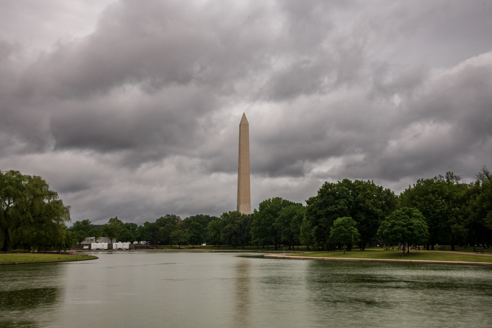
Went into DC on a rainy day adventure to see the tidal basin. DC really does the imperial city vibes well in the rain.
-
Wet late Monday 6/22 or another Fizzle?
SnowenOutThere replied to Weather Will's topic in Mid Atlantic
I chose to take a rain swim, then head into DC for my activities. Got to see the reflection pool in person… lots of national guard people. -
2026 Mid-Atlantic Severe Storm General Discussion
SnowenOutThere replied to Kmlwx's topic in Mid Atlantic
At least to myself the velocity scans look rather unimpressive.- 966 replies
-
- 1
-
-
- severe
- thunderstorms
- (and 7 more)
-
2026 Mid-Atlantic Severe Storm General Discussion
SnowenOutThere replied to Kmlwx's topic in Mid Atlantic
No visible rotation from my vantage point. Massive downdraft/microburst visible though. -
2026 Mid-Atlantic Severe Storm General Discussion
SnowenOutThere replied to Kmlwx's topic in Mid Atlantic
Looks like the hooks reformed over GMU. Saw two bolts from the blue hit right over there -
2026 Mid-Atlantic Severe Storm General Discussion
SnowenOutThere replied to Kmlwx's topic in Mid Atlantic
It’s combined with the cell that popped up over 66 (I was driving west to get the culpeper cell) and it was nasty. Some of the heaviest rainfall you can get. The gust front is hitting me from the cell complex. I’m at the Herndon metro garage if anyone is interested in where my reports are from. They have a 6 story roof.- 966 replies
-
- 1
-
-
- severe
- thunderstorms
- (and 7 more)
-
2026 Mid-Atlantic Severe Storm General Discussion
SnowenOutThere replied to Kmlwx's topic in Mid Atlantic
Going for my Herndon metro intercept point- 966 replies
-
- 1
-
-
- severe
- thunderstorms
- (and 7 more)