SnowenOutThere
-
Posts
5,653 -
Joined
-
Last visited
Content Type
Profiles
Blogs
Forums
American Weather
Media Demo
Store
Gallery
Everything posted by SnowenOutThere
-

2026 Mid-Atlantic Severe Storm General Discussion
SnowenOutThere replied to Kmlwx's topic in Mid Atlantic
Great, really need UVA to get slabbed to cancel my finals so I'm putting all my eggs in this basket.- 1,472 replies
-
- 1
-

-
- severe
- thunderstorms
- (and 7 more)
-
2026 Mid-Atlantic Severe Storm General Discussion
SnowenOutThere replied to Kmlwx's topic in Mid Atlantic
I wasn't alive for the storm but reading the Wikipedia article and apparently the tornado warning was issued with only a 5 minute warning time for the city itself. Just crazy to think about and how far we've managed to come since then. Shows the value that the NWS and research provides us and what happens when they are neglected or undeveloped. Also sort of neat that it added to the conversation to change to the EF instead of the regular F scale.- 1,472 replies
-
- 3
-

-

-
- severe
- thunderstorms
- (and 7 more)
-
You know as well as I do that calling my posts ludicrous was a political statement by itself. It is cowardly to then turn your tail and run when confronted by making an accusation. Either stay silent or be prepared to answer for your remarks - I am not the one who brought "political stuff" up... unless you think the claim that curiosity and engaging with others is inherently "woke"
-
2026 Mid-Atlantic Severe Storm General Discussion
SnowenOutThere replied to Kmlwx's topic in Mid Atlantic
SPC has us in a day three marginal risk which prompted me to take a look NAM has a line of broken storms enter the region after a bit of clearing with 1000 CAPE values running right along I-64. We have 40-50kt of bulk shear and a good bit of lower level turning. Reminds me a bit of March 15th but less extreme and maybe a bit more heating. Wonder what yall think about it- 1,472 replies
-
- 2
-
-
- severe
- thunderstorms
- (and 7 more)
-
The rain gives it a certain vibe. I don't mind it when I'm walking around UVA.
-
I just think we all need to be kinder to one another. Not some grand project of ideology or anything, but just why not be nice to the people you meet, assuming ill intent or expectations (this is beyond Cape's og post ofc) of others you don't know burdens yourself and them. That said, please I want to know what you consider my "ludicrous posts" are.
-
I feel like we tend to get at least a couple days with storms in April even if our bread and butter months is mid May through July. We had March 15th this year and then just nothing.
-
Taking this to banter but @Maestrobjwa is right. He just asked a question there was absolutely no need for any attitude. As a society we shouldn't treat others curiosity or questions as a "ever heard of google" and not my problem! They are opportunities to learn and engage with people. A comic I love describes what I think to a tee.
-
Leaving UVA for the semester next Friday and I'm pissed now that I've realized I won't get a single shot of a shelf cloud over grounds. There hasn't even been a single opportunity! Seriously, our severe weather game this year seems unusually weak.
-
Cville is getting split bad by two storms passing just north or south of it.
-
Mesoscale analysis seems to say those in NW VA should be the winners with a localized area of nice cape and a warm front to their north. Though of course, our ML lapse rates suck but our SL lapse rates are unconditionally unstable. We also have a good amount of downdraft Cape reaching 900 plus for central VA. Nice area of 2-6 Lapse rates there too. Maybe some isolated severe gusts if a storm pops up and gusts out. Ultimate guess is that area of N VA and then a secondary winner somewhere near/east of Cvill.
-
I'm planning on basing in the village of Kandersteg (near Interlaken) which has nice public transportation up and down the mountains while being on a train station for easy in/out access. I don't know if I can make this trip work with timing of my finals and then other commitments but I'm really hoping I can! Quick question, but how hard/easy was it to navigate if you only know English?
-
Man thats awesome. I haven't been out of the country yet but I possibly planning to go to the Alps this May before I start my summer coaching job. Do you have any recommendations on locations/any other advice?
-
Hey all, just wanted to ask if anyone knew any good sites for seeing past synoptics (namely 500mb height anomaly/jet stream and surface maps) I know the NWS has their surface map archieves but I remember being recommended a site one time with all that information. Paging some of the mets @MillvilleWx @WxUSAF
-
It's time to grade Winter 2025-26(now that it's actually over)
SnowenOutThere replied to CAPE's topic in Mid Atlantic
Man I've wanted to make a breakdown post of my thoughts on this winter but I'm not sure I'll ever get around to it. I'm torn between giving this winter a harsh C- grade based on missing three HECS - one of which should've been a slam dunk to the point we had to be unlucky to miss - and the fact that the snowcrete sucked ass for all the activities I enjoy doing outside. I could characterize this winter as one that fell short in nearly every event outside of the December ones. On the other hand, this winter could be an A grade. We had 2 early December snowfalls! I went out to WV for a good snowstorm the 10th of November, and then again for two beautiful hikes in early January. The Jan 25th storm was a very cool experience - though flawed - it is one I will remember. Then we got a surprise snow burst at UVA in Feb (and one later in March with flowers out which was amazing). I got to travel up to NOVA for the missed late Feb HECS and got to enjoy a period of really heavy snow. I really think how you grade this winter comes down to what you value and what you're able to put aside. If you put aside the what ifs? Or the expectations of what it could've been - or should've been in case of Jan 25th - you get a winter that was extremely memorable, cold, had plenty of decent snow events (and some fun surprise ones!). Yet, I don't think its entirely fair to isolate it from that expectation. We rarely get chances like this winter and they did fall short. We did miss a HECS because literally everything that could go wrong from five days out did go wrong! We missed two more in less abnormal or rare ways, but we still did ultimately barely miss them. On a personal note, it is also the winter where I first really understood the mechanics of synoptics for the first time. This was both a blessing and a curse. It's amazing to be able to talk with some of the posters I've looked up to for years on some, though of course unequal, level. It's so cool to see how the jet interacts with synoptics to produce lift and cyclogenesis. It is an amazing feeling to be able to forecast based not off any surface map and then get it right and watch it snow (see the December storms)! It, however, also means it sucks to watch a setup that should, and was so close to, producing big simply fail to come together right. There is an acute awareness of exactly what went wrong (850 low in Ohio valley) and what is it doing, but you are just a spectator. Its a weird dynamic and one I need to learn better (probably involves only allowing myself to read models/post between 1pm and 7pm or something). Since I probably won't get around to a storm by storm breakdown I'll give my final grade here: B+. I can't quite go higher considering the snowcrete really messed up my ability to do anything fun outside for a month, alongside the mentioned close calls; but, going any lower is disrespecting what this winter actually was. Finally, I have kept an achieve of google docs with all my synoptic breakdowns throughout the winter. If anyone has interest in revisiting them/the storms let me know and I can clean them up and make a post with the links. -
Speak for yourself. I'm up past 60 degrees at UVA. Beautiful spring day with a nice breeze.
-
One benefit of the warm weather is that my plan to wake up and take pictures of the sunrise is a lot less chilly for tomorrow. Otherwise, its been a dry heat which is better than a humid one... though, any temperatures above 80 this time of year aren't ideal.
-
I would recommend using Tropical tidbits with the NAM model selected. (Here is a link https://www.tropicaltidbits.com/analysis/models/?model=nam3km®ion=us&pkg=mslp_pcpn_frzn&runtime=2026040712&fh=0) It will show the same thing as the previous tool. Of course, you could also change models to some other ones to help as well.
-
Wedge had been gone since 9am in Charlottesville.
-
Hmmm, some boundaries appear to be draped W-E across Reston. Other boundaries are from the Potomac moving west. Could see something interesting things happen.
-
2026 Mid-Atlantic Severe Storm General Discussion
SnowenOutThere replied to Kmlwx's topic in Mid Atlantic
Severe warned storms down around Roanoke. Seems more active than forecasted so far.- 1,472 replies
-
- 1
-
-
- severe
- thunderstorms
- (and 7 more)
-
Nope, mind posting?
-
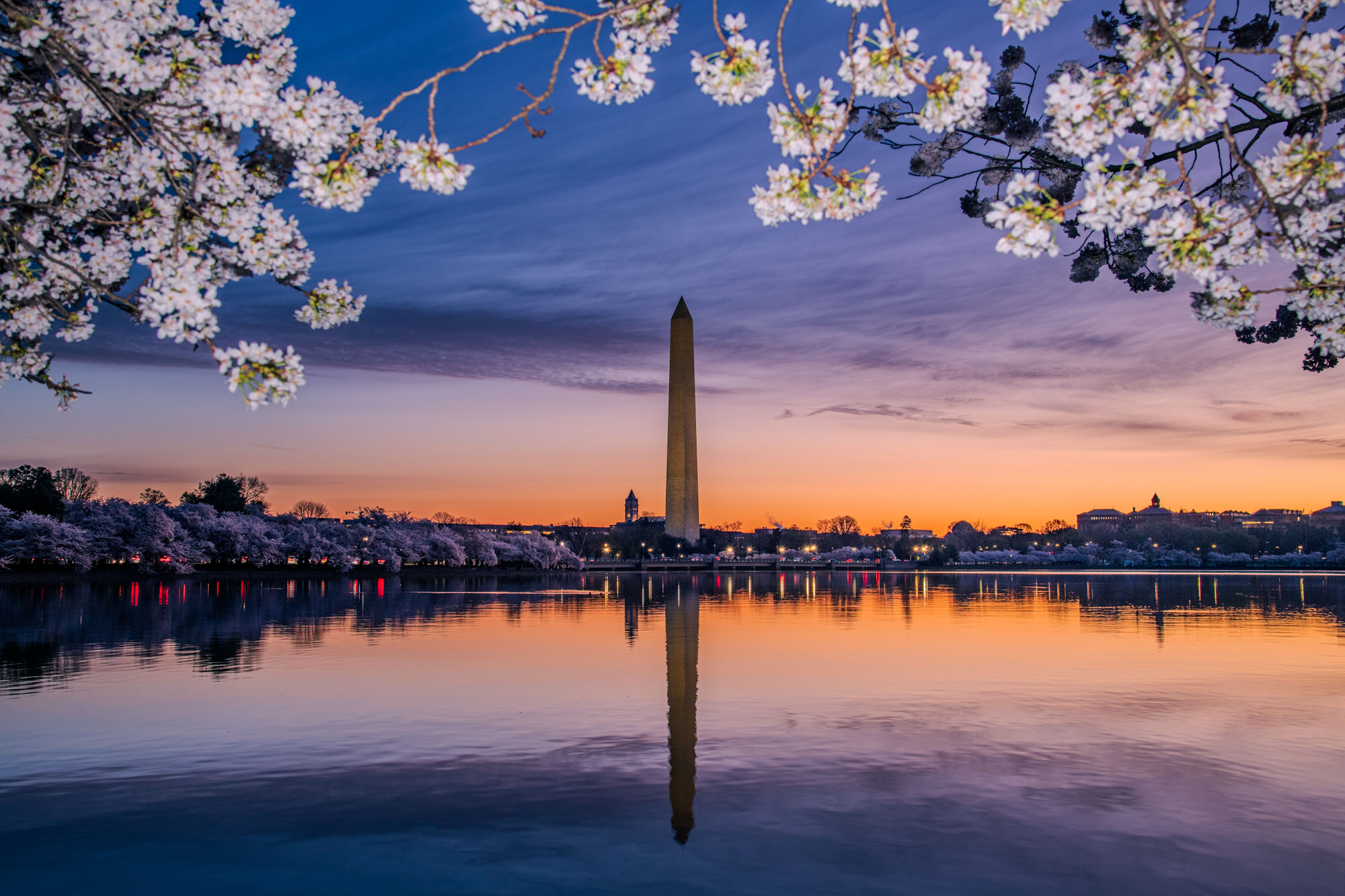
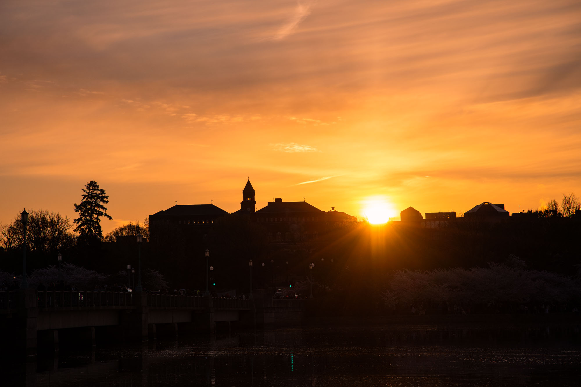
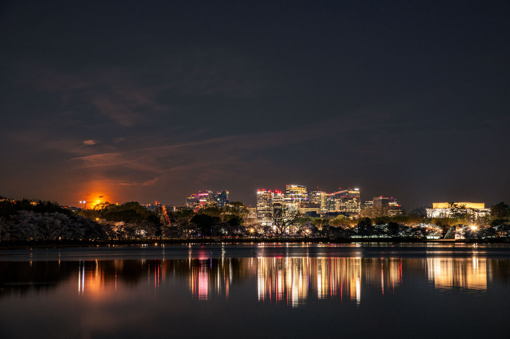
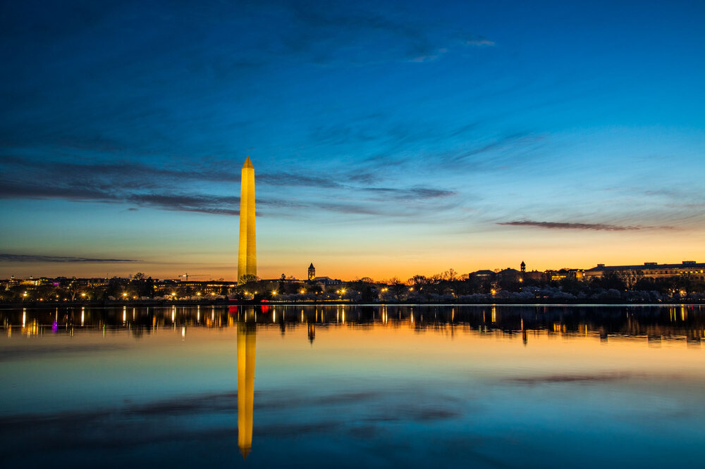
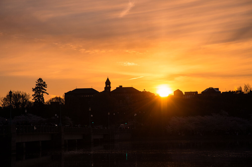
Highly recommend going out and doing this at least once in your life. While I think the cherry blossoms are otherwise overhyped and overdone; if you manage to get there early in the morning to watch deep night fade into morning's glow it is a magical experience.

-
Went on an adventure to see the cherry blossoms last weekend in DC. Started by waking up at 3am to get there early enough to get shots of the moon sinking over the horizon, of which, I couldn't be happier with. By 5am first light started to appear and with it the crowds. Pulses of people streamed onto the walkways. I went around the loop for sunrise. Got some shots along the way, and arguably my best ones of the day. Finally, the sun began to breach the DC skyline. At the end I was out of DC by 8am. Great experience, and huge thanks to my Dad for driving me in and finding parking.
- 567 replies
-
- 18
-
-

-
-

-
Start. The. Bus. Up.