SnowenOutThere
-
Posts
5,666 -
Joined
-
Last visited
Content Type
Profiles
Blogs
Forums
American Weather
Media Demo
Store
Gallery
Everything posted by SnowenOutThere
-
This cannot be happening
-

2026 Mid-Atlantic Severe Storm General Discussion
SnowenOutThere replied to Kmlwx's topic in Mid Atlantic
And we’ve gained anafront “snow”. What a reversal- 1,707 replies
-
- 2
-

-

-
- severe
- thunderstorms
- (and 7 more)
-
Wait what the fuck is going on here.
-
Definitely no mid level dry air to eat away at the snow too! Just perfect conditions
-
My favorite "heavy snow" sounding I've seen yet
-
2026 Mid-Atlantic Severe Storm General Discussion
SnowenOutThere replied to Kmlwx's topic in Mid Atlantic
FV3 soundings seem legit as the squall line approaches. Steep (nearly unconditionally unstable lmao) low level lapse rates. Decent turning of wind with height and sheer increase. Just lacking in the cape department past the LCL. Would need just a bit of a trigger to get some storms I think considering the lower levels lapse rates. -
Difference between nova and cvill is astounding. Back in cvill the crickets are out and some trees/daffodils are blooming.
-
Present but wondering why I’m still in class after the ap exams type feeling. Something could still happen but would take a miracle. Unironically a January Storm redux but somehow even more impactful. I’d be seated for this one.
-
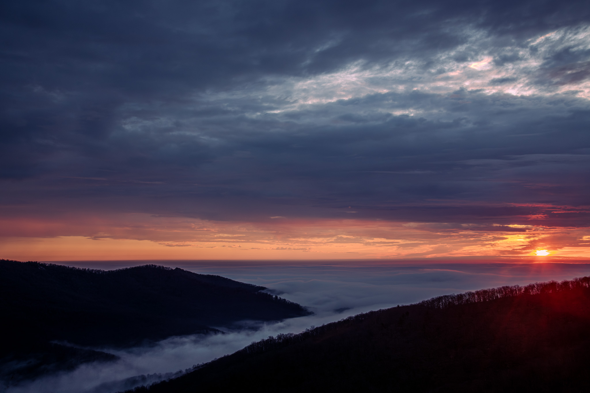
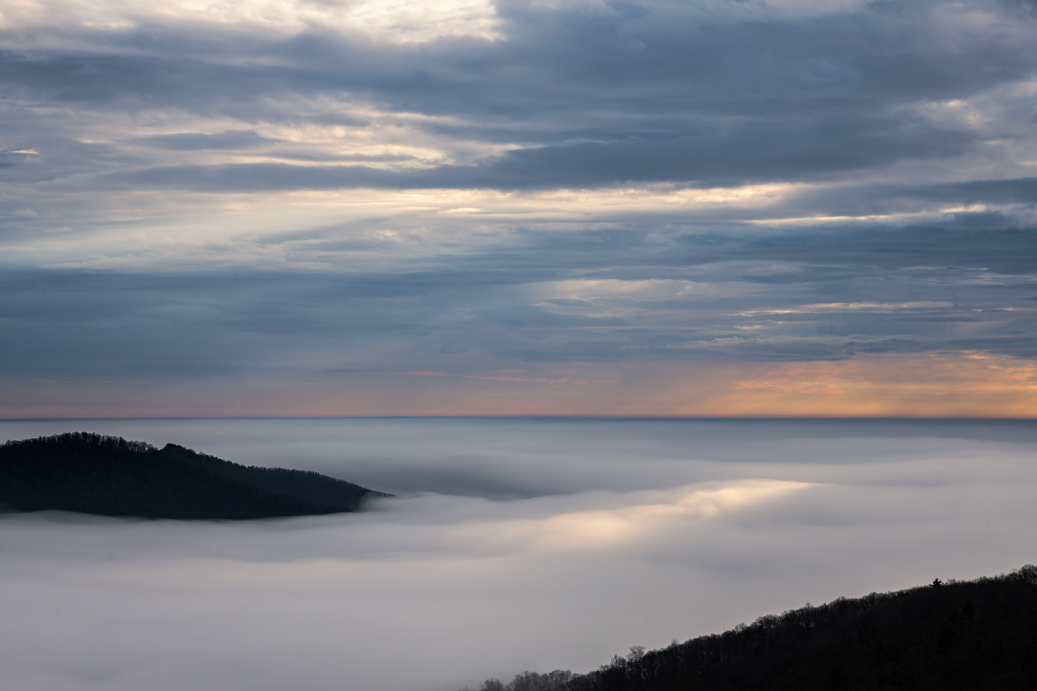
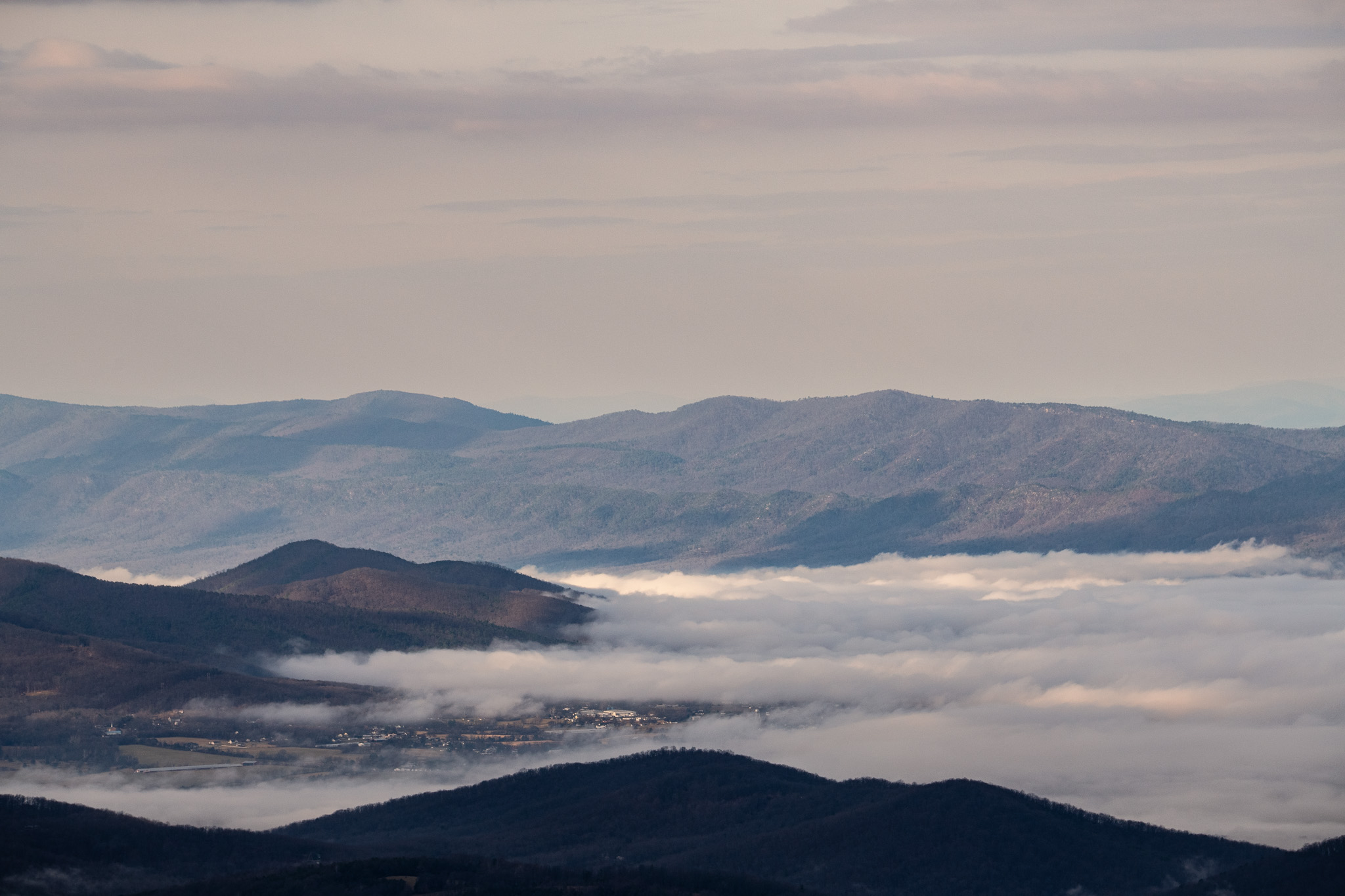
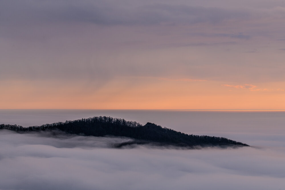
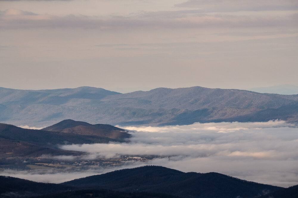
Pictures from my sunrise Shenandoah trip on Friday. Drove out from NOVA at 5am and had to brave 30 miles of dense fog as I neared the mountains. Then as I started up the mountain the clouds cleared as temperatures climbed through the low level inversion. Had a perfect clearing to the east to see the sunrise sandwiched between the cloud decks. Watched it rise into the mid level clouds with my friend and got some pictures of rain wisps falling in the distance with a lenticular cloud making an appearance (not captured). Got lucky with a brief period of sun rays hitting the cloud deck. Afterwards hiked to Mary's Rock and got to see the difference in cloud coverage between the east and west side of the mountains. Finally we headed back down and saw the sun finally clear out the mid level clouds. Was a magical experience.


- 648 replies
-
- 22
-
-

-
Went up to Shenandoah and watched the sun rise above the inversion with a friend! Hiked up to Mary’s rock and then the mid level clouds broke and it got sunny. Could see the mist try to build and make its way up the mountain. At the top it was mid 60s and within 5 miles it was 50s and grey.
-
2026 Mid-Atlantic Severe Storm General Discussion
SnowenOutThere replied to Kmlwx's topic in Mid Atlantic
Had first thunder of the season!- 1,707 replies
-
- 4
-
-
- severe
- thunderstorms
- (and 7 more)
-
I’m up in nova for break right now so I’ll be on the north side of Shenandoah. I need to take a better look this evening but I’ll @ you. Though honestly i plan to nowcast using https://weather.cod.edu/satrad/?parms=local-W_Virginia-truecolor-24-0-100-1&checked=map&colorbar=undefined and for you the Charlottesville airport has ceiling height (though not ceiling top).
-
Yeah… on spring break so I woke up less than an hour ago. Thought the cams looked better for tomorrow. Curious to know what you think though
-
What sort of convection is it? Elevated I assume since the temp inversion near the surface
-
Hoping the BDCF clears far enough south tomorrow so I can wake up early and watch the sunrise over the cloud deck in Shenandoah. Been a bucket list item for me.
-
Outta gas and Outta Time: Early March Winter Storm finale
SnowenOutThere replied to Ji's topic in Mid Atlantic
Spoiler alert it’s freezing drizzle to my eyes -
Outta gas and Outta Time: Early March Winter Storm finale
SnowenOutThere replied to Ji's topic in Mid Atlantic
Gradient is tightening and we are slowly losing the battle but around the immediate DC area we're still at -2 degrees. -
Outta gas and Outta Time: Early March Winter Storm finale
SnowenOutThere replied to Ji's topic in Mid Atlantic
Man driving back on FFX parkway and Reston town center area got screwed. Areas a mile or two north got the initial band and then a couple miles south moderate dendrites started with more snow on the ground. Now home and nice fluffy snow. Perfect for a post hike hot tub -
Outta gas and Outta Time: Early March Winter Storm finale
SnowenOutThere replied to Ji's topic in Mid Atlantic
Interesting. I hiked Seneca regional park (super pretty, pictures will come later) but didn’t notice a different between the top of the hills and the Potomac at the bottom. Guess everything was cold enough. -
Outta gas and Outta Time: Early March Winter Storm finale
SnowenOutThere replied to Ji's topic in Mid Atlantic
Went on a drive to Seneca state park to hike and the snowfall gradient on ffx parkway past route 606 was insane. In half a mile went from snow topping the trees to snow on the grass. Would’ve been so pissed to be right on that line. -
Outta gas and Outta Time: Early March Winter Storm finale
SnowenOutThere replied to Ji's topic in Mid Atlantic
Going to hike Seneca state park -
Outta gas and Outta Time: Early March Winter Storm finale
SnowenOutThere replied to Ji's topic in Mid Atlantic
You can tell we actually have good dynamics aloft from the “flurries” being dendrites but we need some juice -
Outta gas and Outta Time: Early March Winter Storm finale
SnowenOutThere replied to Ji's topic in Mid Atlantic
Did see a couple cams move towards this overnight but wanted to hope it wouldn't happen. Sucks to be between bands but what can you do. -
Outta gas and Outta Time: Early March Winter Storm finale
SnowenOutThere replied to Ji's topic in Mid Atlantic
-
Outta gas and Outta Time: Early March Winter Storm finale
SnowenOutThere replied to Ji's topic in Mid Atlantic
Hey we're in the same boat! ... this boat sucks. At least we seem to have a decently put together precip shield making its way east.