WXNewton
-
Posts
882 -
Joined
-
Last visited
Content Type
Profiles
Blogs
Forums
American Weather
Media Demo
Store
Gallery
Everything posted by WXNewton
-
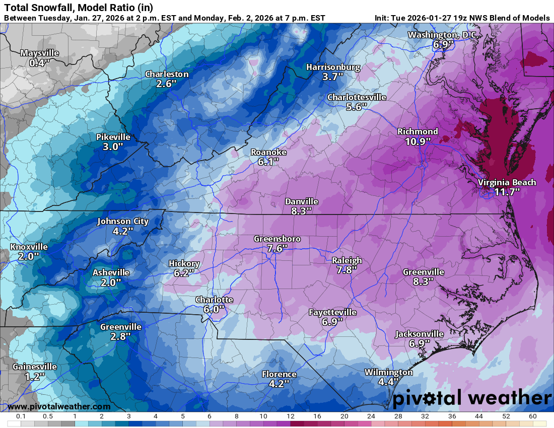
One interesting thing to note, over the past 3 runs in MBY the GFS AI and EURO AI have only made small adjustments in QPF in the amount of .05-.08 either up or down. Where-as the OP EURO and OP GFS over the past three runs have had more wild swings in QPF of .22"-.27". When looking at the ensembles for both EURO and EURO AI as well as GFS those QPF swings are much smoother and the difference is not as much of a wild swing as the OPs have been showing from time to time. Thinking about the models this way and really digging into the ensembles has helped me to not ride each single OP run for the potential wild ups and downs that it may show. All and all after looking at many different averages and taking the fairly rock steady ensembles into account I am starting to feel confident that my area will see somewhere between .35"-.45" of precip and factoring in about a 16-17:1 ratio, amounts should be in the range of 6"-7".
-
The “I bring the mojo” Jan 30-Feb 1 potential winter storm
WXNewton replied to lilj4425's topic in Southeastern States
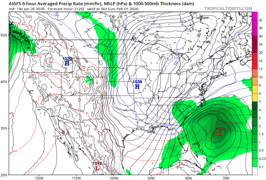
The only model that didn't follow the further east trend was the GFS AI, I wonder how it's been performing? -
The “I bring the mojo” Jan 30-Feb 1 potential winter storm
WXNewton replied to lilj4425's topic in Southeastern States
Yeah, I was more focusing on the footprint of the storm, I have to look closely at it to make sure it wasn't the run before lol. -
The “I bring the mojo” Jan 30-Feb 1 potential winter storm
WXNewton replied to lilj4425's topic in Southeastern States
Remained consistent! -
The “I bring the mojo” Jan 30-Feb 1 potential winter storm
WXNewton replied to lilj4425's topic in Southeastern States
The trend on the GFS AI is really impressive....gif.dfcb756bd31bbcf162c5454693165a3f.gif)
-
The “I bring the mojo” Jan 30-Feb 1 potential winter storm
WXNewton replied to lilj4425's topic in Southeastern States
Does anyone remember the website for cmc-collaboration model. I remember it used to have a cool look to it! -
The “I bring the mojo” Jan 30-Feb 1 potential winter storm
WXNewton replied to lilj4425's topic in Southeastern States
NWS blend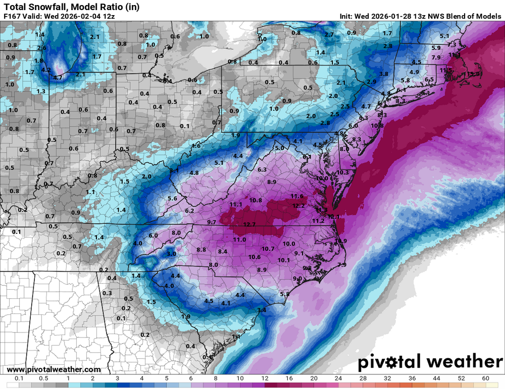
-
Yes. I just was thinking the same thing.
-
RGEM was going to be nice too!
-
The “I bring the mojo” Jan 30-Feb 1 potential winter storm
WXNewton replied to lilj4425's topic in Southeastern States
GEFS becoming pretty consistent of the overall totals and area to be affected. Looks like major jumps, have turned into wobbles at this point. I would expect minor shifts each run, with the overall footprint starting to lock in..gif.3ba9f1340bb8dd58f0c78f8410743e50.gif)
-
The “I bring the mojo” Jan 30-Feb 1 potential winter storm
WXNewton replied to lilj4425's topic in Southeastern States
The 06z NAM and RGEM was starting to handle business. -
The “I bring the mojo” Jan 30-Feb 1 potential winter storm
WXNewton replied to lilj4425's topic in Southeastern States
GEFS is trending a little further north each run..gif.4a0da1fdf230500fe79f733f0e71c17c.gif)
-
The “I bring the mojo” Jan 30-Feb 1 potential winter storm
WXNewton replied to lilj4425's topic in Southeastern States
2003 Jan storm kind of did this, had a precip maxima Foothills, NW Piedmont and then another precip maxima right along the coast. -
The “I bring the mojo” Jan 30-Feb 1 potential winter storm
WXNewton replied to lilj4425's topic in Southeastern States
00z AI GFS trending west each run...Here's the last 6 runs.
-
The “I bring the mojo” Jan 30-Feb 1 potential winter storm
WXNewton replied to lilj4425's topic in Southeastern States
The GFS is really expanding the precip shield to the NW and putting more and more moisture west each run. Here's the last 6 runs, not sure where it will stop.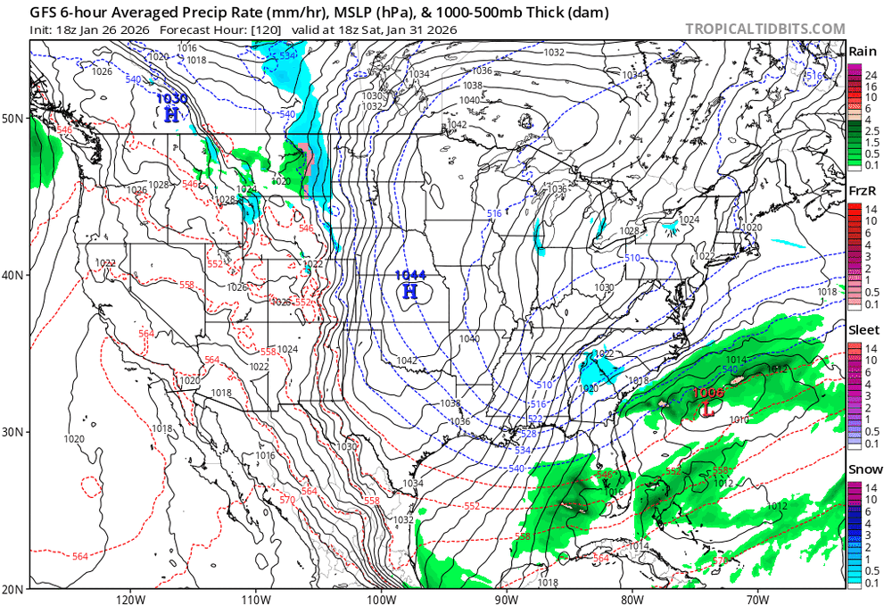
-
The “I bring the mojo” Jan 30-Feb 1 potential winter storm
WXNewton replied to lilj4425's topic in Southeastern States
ICON ENS are a little wetter and don't agree with the OP for the most part. -
The “I bring the mojo” Jan 30-Feb 1 potential winter storm
WXNewton replied to lilj4425's topic in Southeastern States
Also that was more of a Sunday storm, so in theory we've already made it closer on this one. -
The “I bring the mojo” Jan 30-Feb 1 potential winter storm
WXNewton replied to lilj4425's topic in Southeastern States
Yes was in Dec. I remember seeing the red screen on TWC and being in 12-18" never saw a flake. -
The “I bring the mojo” Jan 30-Feb 1 potential winter storm
WXNewton replied to lilj4425's topic in Southeastern States
Euro is going to be a much better run, increasing totals 3 runs in a row now. -
Totally agree! this is where the lee-side enhancement could really take off.
-
The “I bring the mojo” Jan 30-Feb 1 potential winter storm
WXNewton replied to lilj4425's topic in Southeastern States
Latest NWS model blend...
-
The “I bring the mojo” Jan 30-Feb 1 potential winter storm
WXNewton replied to lilj4425's topic in Southeastern States
GFS ENS trended over the last 4 runs. Factor these totals at 15:1 and from the mtns to the coast is 6"-12"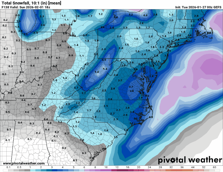
-
The “I bring the mojo” Jan 30-Feb 1 potential winter storm
WXNewton replied to lilj4425's topic in Southeastern States
According to this, precip was definitely enhanced in western NC when compared to 6z. Very interesting to see how this plays out, but it kind of did like the Euro, 12z looked a tad better than 6z. -
The “I bring the mojo” Jan 30-Feb 1 potential winter storm
WXNewton replied to lilj4425's topic in Southeastern States
Factoring in 15:1 ratios or 18:1 it was a state wide 6-9" snowfall. -
The “I bring the mojo” Jan 30-Feb 1 potential winter storm
WXNewton replied to lilj4425's topic in Southeastern States
I would necessarily call this a trend that it shifted East, my take on it is the precip just wasn't as heavy as 6z looks more like a wobble to me and with potential ratios being higher this run was a significant snowstorm per NC standards for the whole state. Here are the last 4 runs and I like where we stand, let's see what Ensembles say.