WXNewton
-
Posts
882 -
Joined
-
Last visited
Content Type
Profiles
Blogs
Forums
American Weather
Media Demo
Store
Gallery
Everything posted by WXNewton
-
Just a hair over 3" here since Thursday afternoon. Looking at the radar another round is going to build in over the next few hours. Friendly reminder, if anyone is building a house and using a plastic septic tank, please fill with water before any heavy rain moves in. My new neighbor found out the hard way yesterday and his tank basically floated out of the ground and snapped all the plumbing going into it.
-
The warm nose is rearing it's ugly head. We just can't seem to win.
-
I am really thinking ground temps are going to cut back on any totals we might see. It's definitely tough to get accumulations this time of the year outside the MTNS.
-
Getting white on the GA/TN line... https://smartway.tn.gov/allcams/camera/4625
-
Snowing in Huntsville ALABAMA! https://hmcpl.org/DowntownCam
-
28.4 this morning, forgot to unhook the water hose and ran outside at 4 am luckily before we had any issues.
-
March weather is wild! Had a darn near flood come through about 45 mins ago lightning and thunder, temps have dropped 17 degrees here since 6:30 am.
-
Cousin in Todd said they just switched over.
-
Looks like snow falling at the Boone Lake cam. https://www.resortcams.com/webcams/boone-lake/
-
Latest HRRR has definitely beefed up since 12z. Watauga, Ashe/Allegheny counties, verbatim heavy snow. 10am-1pm timeframe.

-
https://www.earthcam.com/usa/massachusetts/provincetown/?cam=capecodbay
-
This webcam is absolutely insane, basically down to only seeing the stop sign now lol!
-
Wow, that's amazing and kind of scary at the same time. Unbelievable, what an extreme situation.
-
00z HRRR has about 1" of precip falling between 3am-8am. Should be heaviest rates during those hours. I would expect 9" -10" piling up during that 5 hr stretch.
-
Checking in from NC...anyone have a good webcam link to watch?
-
The RAP model pretty much shows the stall start to happen right when the pressure begins to significantly bomb out. Here's a 9 hr loop of virtually very little to no movement from about 8 pm tomorrow night until 5 am Monday morning.
.gif.6e98b719217ed0c4064be0d3eb0a01d2.gif)
-
For real, it makes you really question how most of these folks live like sheep believing everything, but the real data and the facts.
-
It is frustrating to dedicate hours and hours into model runs each day leading up to the storm and realizing what is about to take place and then some random person who watched the 6 o'clock news yesterday argues with you on whether it's going to be a storm or not. I am always fascinated at the average person's understanding of the weather or lack there of!
-
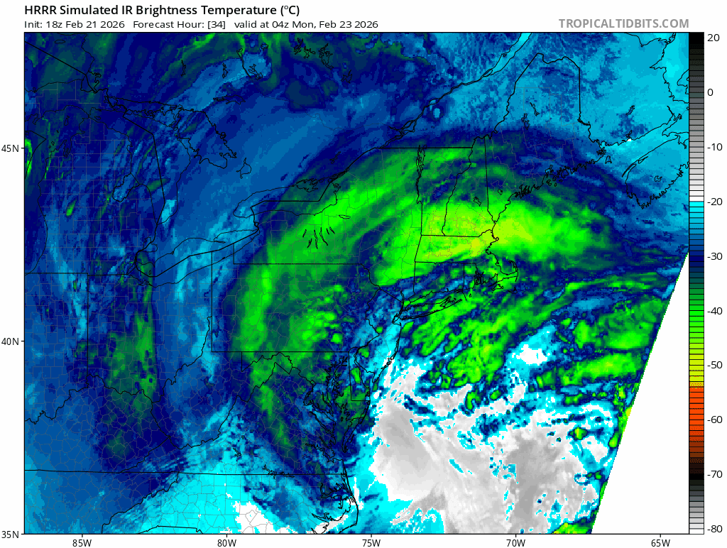
The explosion on the HRRR is simply amazing...

-
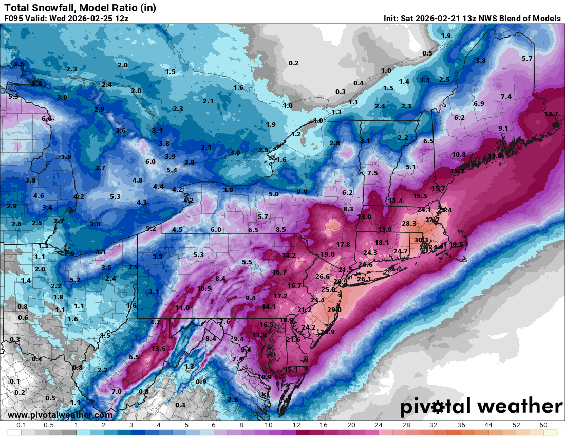
EPS still playing catch-up...looks like totals will keep bumping up until about go-time.
-
NBM

-
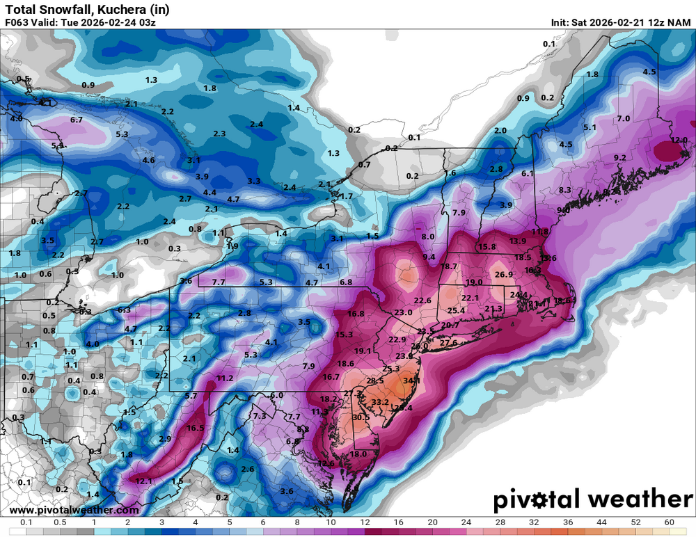
12z NAM Kurchea
-
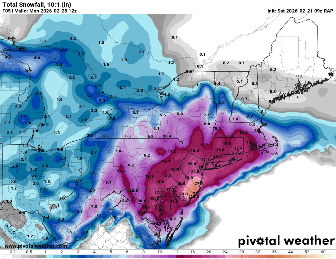
NAM 3km is cranking!!! Man what a monster!
.gif.6d51d3abc6a66e65640d9c36a90af3c8.gif)
-
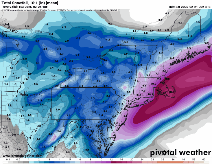
RAP...and more to come...

-
Checking in from the SE forum! I know it's the long range RAP model, but what a beautiful thing to look at. I feel like it did very well with our snow at the first of the month!
.gif.6789caecf10d3c7e0964a11440bee9a9.gif)