WXNewton
-
Posts
882 -
Joined
-
Last visited
Content Type
Profiles
Blogs
Forums
American Weather
Media Demo
Store
Gallery
Everything posted by WXNewton
-
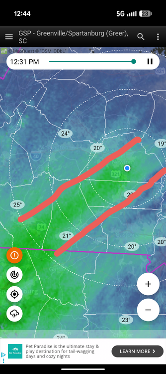
This band has been absolutely hammering MBY the past 1 hr and half. Not really moving but definitely, 1"+ hr rates.
-
Yes check your sensor mine was doing the same thing cleaned it out now down from 24.7-20.6
-
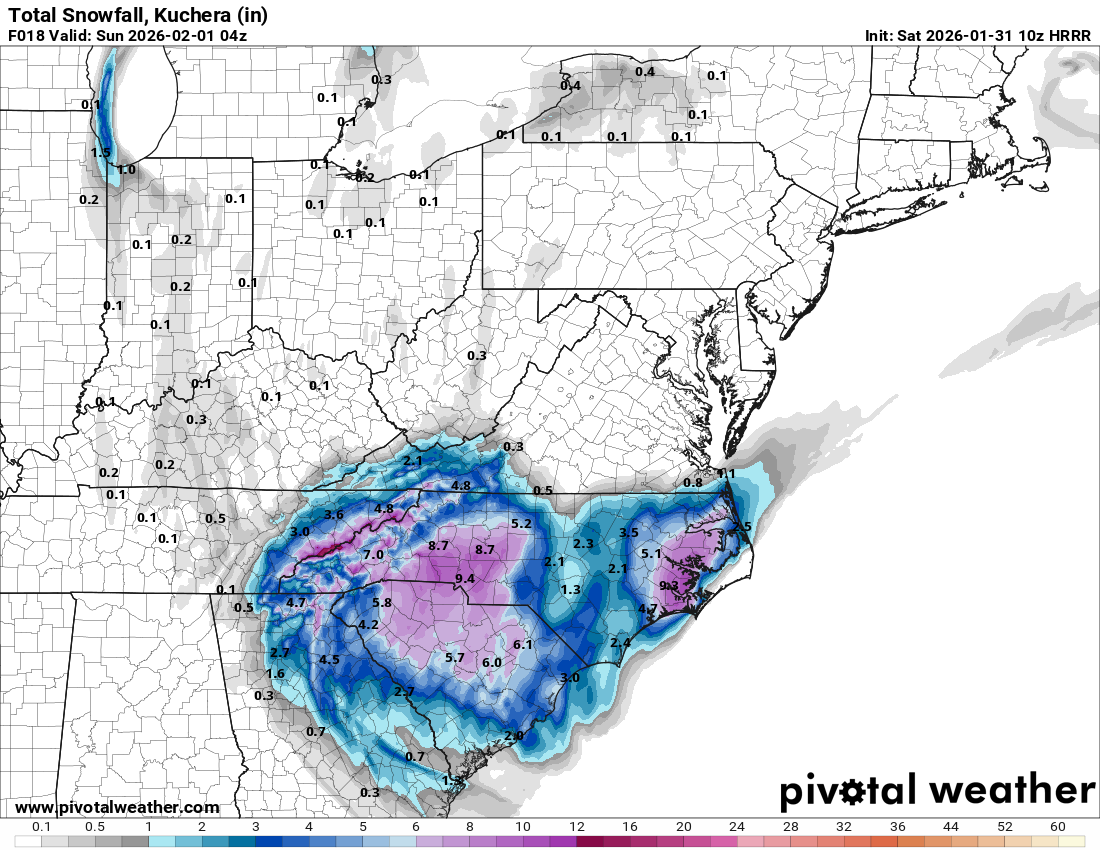
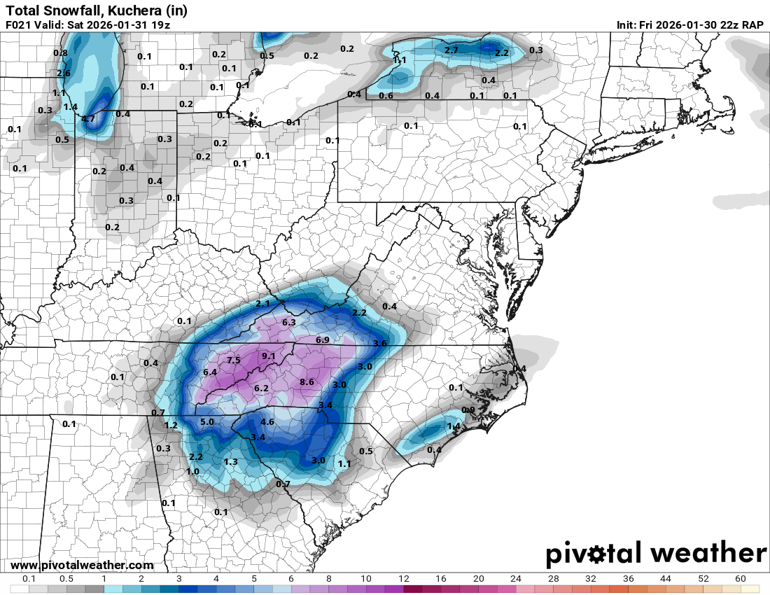
HRRR agrees with RAP, here's the latest...

-
January 30th- Feb 1st ULL and coastal storm obs
WXNewton replied to JoshM's topic in Southeastern States
22.8/21- Started snowing at 3 o'clock working on a little over an inch at this point. -
January 30th- Feb 1st ULL and coastal storm obs
WXNewton replied to JoshM's topic in Southeastern States
Light snow in Newton. 28.1/14.3 -
We got flakes in Newton!!
-
The latest RAP is an absolute crush job for the I77, I85, ,and I40 corridor! I sure hope it holds true!
-
The “I bring the mojo” Jan 30-Feb 1 potential winter storm
WXNewton replied to lilj4425's topic in Southeastern States
Said it all day CLT might be ground zero for the West. -
The “I bring the mojo” Jan 30-Feb 1 potential winter storm
WXNewton replied to lilj4425's topic in Southeastern States
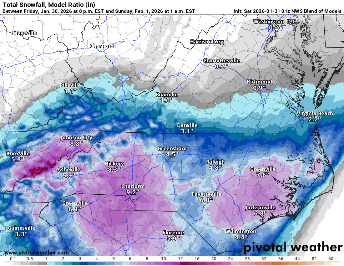
NWS Blend...Best it's been for MBY all day!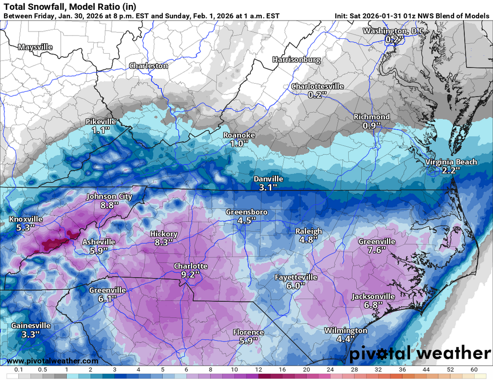
-
I think it is just slowing the ULL some, seems like once it closes off a little earlier than previous runs showed it spins SE slower and has also corrected west a little bit. RAP seems to start and hour or two earlier than HRRR in MBY.
-
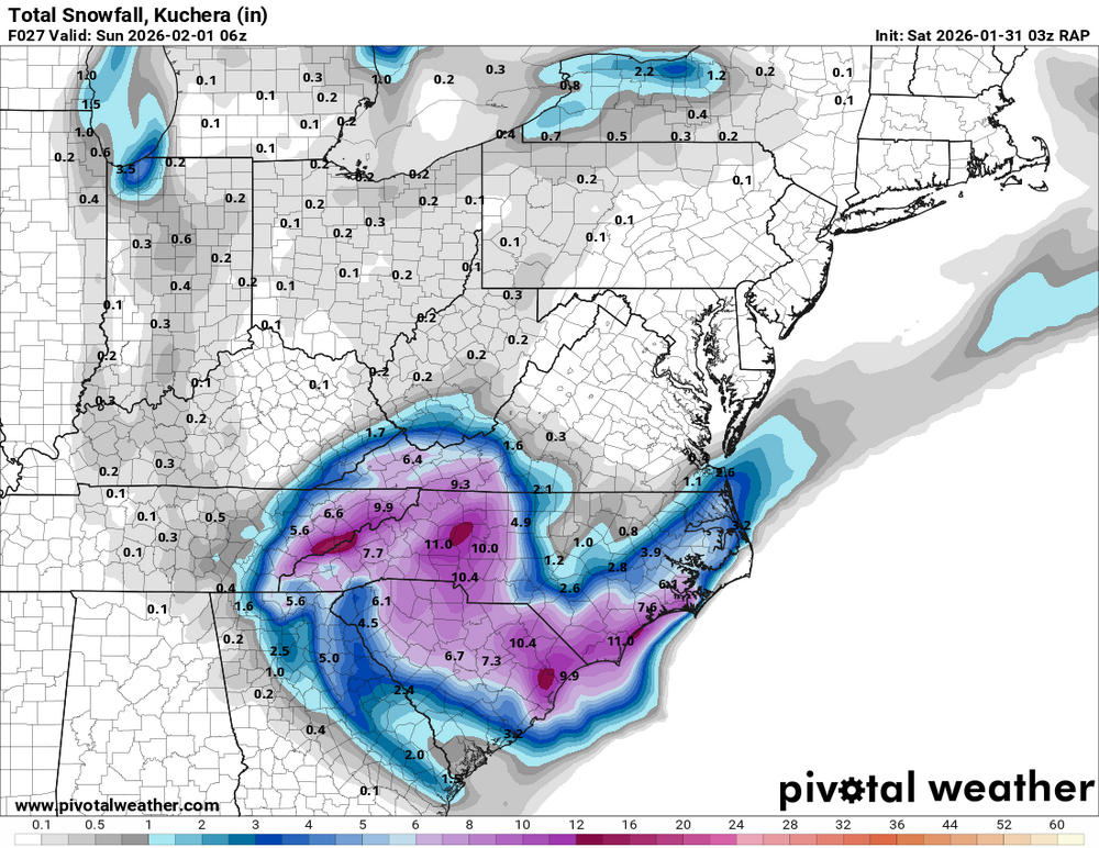
Latest RAP has almost 9" in HKY by 2 p.m!! Still a lot to go after that!! This thing is looking good!

-
I remember getting down to about 20-23 during that storm. So yes, this one very well maybe colder.
-
Can't ask for more than this guys! Pretty much all 12z global models give us 6"+, Lets GO!!
.gif.65dfd05f313609e97aaf1e249eebebb4.gif)
-
Back to back winter storms with temps in the teens just makes my heart happy! Wow what a great week of weather this has been, little to no sleep has been worth it!
-
January 30th- Feb 1st ULL and coastal storm obs
WXNewton replied to JoshM's topic in Southeastern States
Hit 21.2, currently up to 25.2/12.4. North side of the yard is still sleet packed! -
If you had to extend this over Catawba County, would you be 4-8 there too?
-
The “I bring the mojo” Jan 30-Feb 1 potential winter storm
WXNewton replied to lilj4425's topic in Southeastern States
Euro,GFS,icon,nam, RRFS 6z.gif.1b8de3dc137f276e34bc444fda14e994.gif)
-
This past weekend storm, it showed a lack in precip when compared to the globals. The actual QPF was a lot closer to what the NAM was showing 24 hrs before the storm than what any of the globals had.
-
The “I bring the mojo” Jan 30-Feb 1 potential winter storm
WXNewton replied to lilj4425's topic in Southeastern States
GEFS is locked in the past 3 runs and closely resemble the op as well.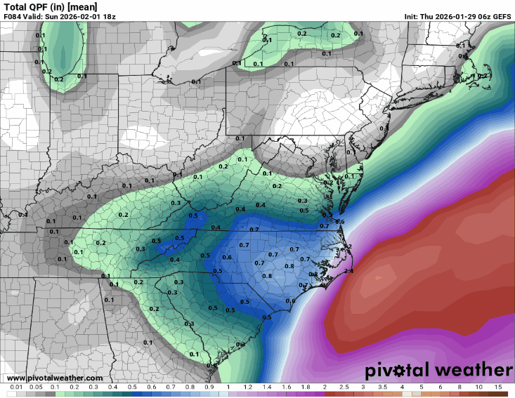
-
The “I bring the mojo” Jan 30-Feb 1 potential winter storm
WXNewton replied to lilj4425's topic in Southeastern States
Last 3 runs of GFS...pretty locked in!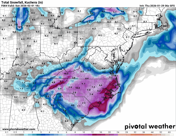
-
06 EPS another step our way! Also shows that precip maxima on the 06z Euro AI in the same general area.
.gif.7e9b0b63416d3f22700f6bf5837c588c.gif)
-
The “I bring the mojo” Jan 30-Feb 1 potential winter storm
WXNewton replied to lilj4425's topic in Southeastern States
06z EPS vs 00z EPS.gif.5734d6d406d676abb196c7d9d45d1916.gif)
-
The “I bring the mojo” Jan 30-Feb 1 potential winter storm
WXNewton replied to lilj4425's topic in Southeastern States
Nam, 3km looked to be on track for a much better run than 12km. -
The “I bring the mojo” Jan 30-Feb 1 potential winter storm
WXNewton replied to lilj4425's topic in Southeastern States
NBM...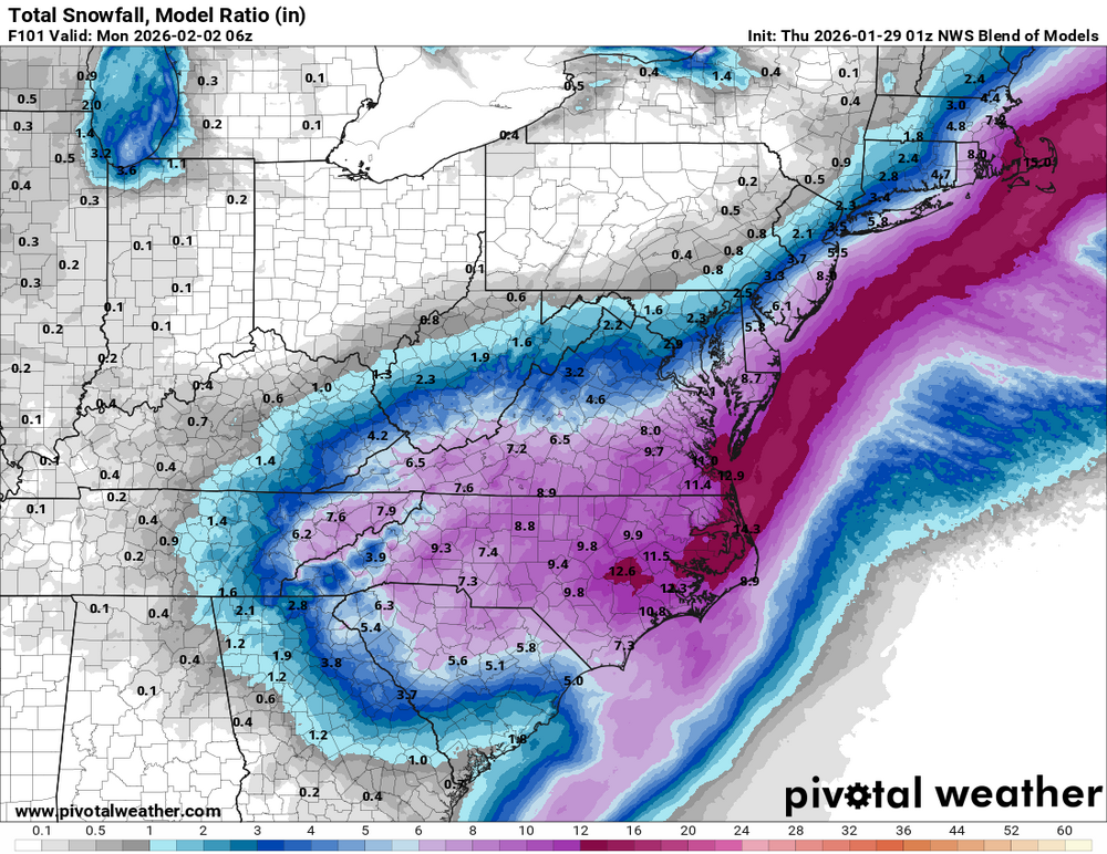
-
18z ICON was a good hit this evening for our area