


Ephesians2
-
Posts
586 -
Joined
Content Type
Profiles
Blogs
Forums
American Weather
Media Demo
Store
Gallery
Everything posted by Ephesians2
-

Richmond Metro/Hampton Roads Area Discussion
Ephesians2 replied to RIC Airport's topic in Mid Atlantic
I will leave the upper level analysis to people who know more about it, but the precip shield and mix line moved South at least 50 miles at 78h It is still going to be more amplified than we would like it but it is an improvement. -
Richmond Metro/Hampton Roads Area Discussion
Ephesians2 replied to RIC Airport's topic in Mid Atlantic
NAM is going to be at least a SLIGHT improvement from what I've seen in the main thread -
January 24-26: Miracle or Mirage JV/Banter Thread!
Ephesians2 replied to SnowenOutThere's topic in Mid Atlantic
Everything came together perfectly from the perspective of producing as close as possible to the theoretical maximum for a single storm in our region. -
Probably going to be me tbh. Will be getting an indoor-safe propane emergency heater and some extra wool blankets tomorrow after seeing those Euro runs.
-
Why is there very little sleet on the Euro- just really snow and freezing rain?
-
12z ICON
-
Richmond Metro/Hampton Roads Area Discussion
Ephesians2 replied to RIC Airport's topic in Mid Atlantic
The optimistic / wish casting perspective is that since the storm needs essentially a perfect phase out west to get that far north, there's a lot of scenarios where something interferes with it. It doesn't seem like this is exactly the same as the north trend that we generally get with big storms due to underestimation of the mix line and the northern extent of the precip. Of course on the other hand, that means that we could get another north trend tomorrow/Friday if last night's euro is right about the upper level pattern. -
Well, I think what people in most of this forum are worried about is continued north trend. And the Euro is already up to an inch of ice for the southern third of this forum (not QPF, but estimated accretion)
-
Richmond Metro/Hampton Roads Area Discussion
Ephesians2 replied to RIC Airport's topic in Mid Atlantic
Hugging the GEFS... -
-
Richmond Metro/Hampton Roads Area Discussion
Ephesians2 replied to RIC Airport's topic in Mid Atlantic
this\ this is obviously earlier on, but there is MUCH more divergence with the GEFS this run than the past few runs. there are actually some suppressed solutions too. overall it's going to be somewhat north of 18z though. likely axis of heavest accumulations from CHO to EZF. -
Richmond Metro/Hampton Roads Area Discussion
Ephesians2 replied to RIC Airport's topic in Mid Atlantic
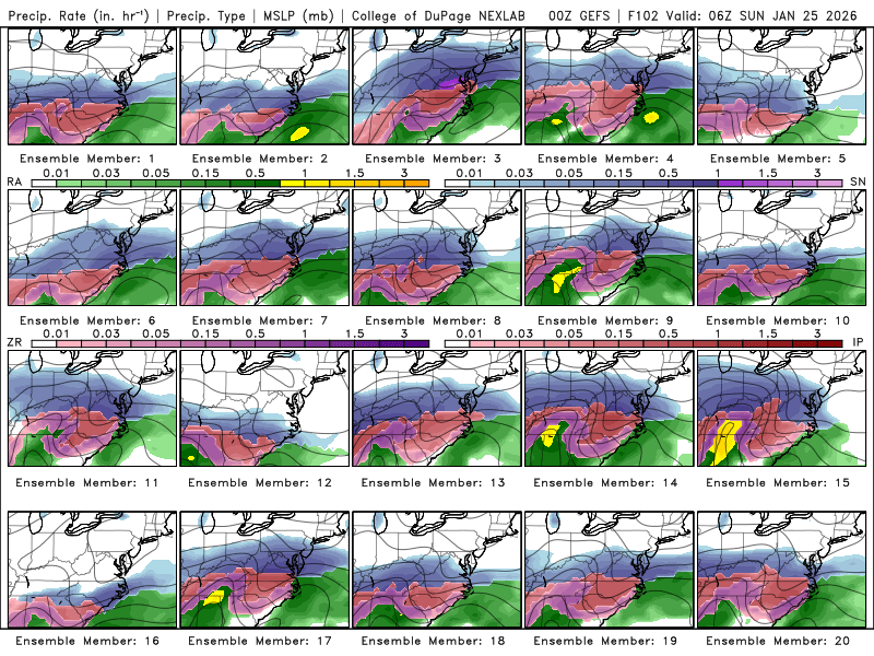
-
Richmond Metro/Hampton Roads Area Discussion
Ephesians2 replied to RIC Airport's topic in Mid Atlantic
not loving the trends on the 00z suite so far. GFS looks more like a coastal than a slider, while the numbers looked good there isn't much more room for error left, and coastal influence definitely will hurt in RIC towards Hampton Roads. CMC jumped north 100 miles, now RIC is on the very southern edge of significant snow - it'll be a sleet bomb most likely. -
CMC is a big jump north. It relegates significant snow north of an axis from about Roanoke to Richmond, VA. Not loving the trends on the 00z suite so far.
-
Much more of a coastal look on 00z GFS.
-
the initial WAA thump was lighter... At 111 total snowfall is around a foot in the Triad before the flip At 108, sleet line to NC/VA border. Taking on a more SW/NE trajectory versus 18z.
-
At 99h, I am not seeing a north trend with respect to the mix line. Precip isn't quite as heavy though... we are not going to see the 2-3' Kuchera totals like last run most likely Biggest shift is it is a bit slower bringing in the precip
-
87h... moderate snow over most of NC... sleet line SLIGHTLY further south than 18z
-
Looking a tad bit slower at 81h
-
That is good to hear ... don't care about being in the jackpot, but was thinking a 100-150 mile shift to the north as has been discussed in this thread would put the freezing rain amounts being advertised in NC right in my backyard - genuinely worrying. I like not losing power for a week with single digit temperatures.
-
It's literally just a copy paste of the most bullish operational models
-
That is absolutely ridiculous. I will be lucky to see half that. It generally seems local TV forecasters are much more responsible. They are more accountable and aren't the sole source of revenue
-
I do NOT want to lose power for a week... if it shifts north 100-150 miles like some are saying in the main thread... I'm kind of cooked I have a feeling though ... going to stock up for long power outage just in case.
-
Are you thinking ice storm potential in Southwest/Central/Southside VA into RIC? Or mostly sleet?
-
Richmond Metro/Hampton Roads Area Discussion
Ephesians2 replied to RIC Airport's topic in Mid Atlantic
some of the individual members on the EPS were genuinely concerning. Not just mixing, but there were a few pure ice storm solutions. I think everyone in this forum would be content with warning level snow --> a couple inches of sleet --> maybe some snow on the backside



