Ephesians2
-
Posts
560 -
Joined
Content Type
Profiles
Blogs
Forums
American Weather
Media Demo
Store
Gallery
Everything posted by Ephesians2
-

Richmond Metro/Hampton Roads Area Discussion
Ephesians2 replied to RIC Airport's topic in Mid Atlantic
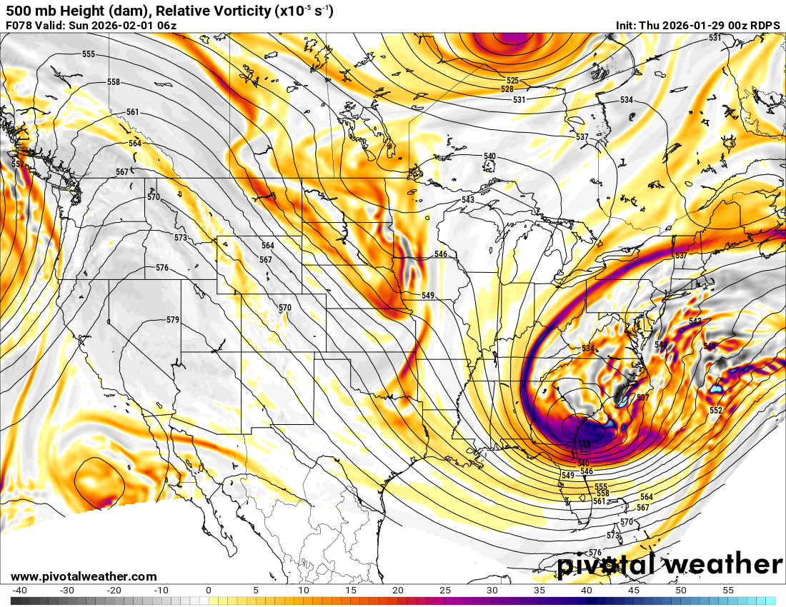
RGEM trending in the wrong direction. Drier, more progressive. -
Richmond Metro/Hampton Roads Area Discussion
Ephesians2 replied to RIC Airport's topic in Mid Atlantic
We are getting most of the trends we want at 500mb but it looks like we have another low developing way offshore robbing moisture from the main one -
Richmond Metro/Hampton Roads Area Discussion
Ephesians2 replied to RIC Airport's topic in Mid Atlantic
12z NAM looks better at 500mb at 45h. West of both 00z and 06z and a tad less confluence -
Richmond Metro/Hampton Roads Area Discussion
Ephesians2 replied to RIC Airport's topic in Mid Atlantic
it's going to be a bump about 50 miles north with the precip shield... gets warning level snow back into the RIC area... really quite similar to the 18z euro, maybe a bit less snow -
The Jan 31 Potential: Stormtracker Failure or 'Tracker Trouncing
Ephesians2 replied to stormtracker's topic in Mid Atlantic
The Fidget Spinner Storm -
Richmond Metro/Hampton Roads Area Discussion
Ephesians2 replied to RIC Airport's topic in Mid Atlantic
All we need is that 500mb low to be 100 miles north. I genuinely think we can get that trend. One thing that did trend in the wrong direction was that stupid shortwave in the Plains. If we can get that out of the way it would be great
-
Richmond Metro/Hampton Roads Area Discussion
Ephesians2 replied to RIC Airport's topic in Mid Atlantic
Ok later on we get some minor negative changes that offset it. Looks like it'll be pretty similar to 18z -
Richmond Metro/Hampton Roads Area Discussion
Ephesians2 replied to RIC Airport's topic in Mid Atlantic
ICON wasn't showing a storm at all until 2 runs ago. Toss. I trust the Euro suite. -
Richmond Metro/Hampton Roads Area Discussion
Ephesians2 replied to RIC Airport's topic in Mid Atlantic
At 66h RGEM might be a hair better looking at 500mb -
The “I bring the mojo” Jan 30-Feb 1 potential winter storm
Ephesians2 replied to lilj4425's topic in Southeastern States
Meh, it looks a tad more progressive (at 60h) -
Richmond Metro/Hampton Roads Area Discussion
Ephesians2 replied to RIC Airport's topic in Mid Atlantic
NAM isn't going to get it done. Not closing off and turning negative in time. It's a bit of a step back from 18z. I'd trust the Euro over the NAM at this range any time though, especially at 500mb. -
The Jan 31 Potential: Stormtracker Failure or 'Tracker Trouncing
Ephesians2 replied to stormtracker's topic in Mid Atlantic
Stolen from the Southeast Forum: -
Richmond Metro/Hampton Roads Area Discussion
Ephesians2 replied to RIC Airport's topic in Mid Atlantic
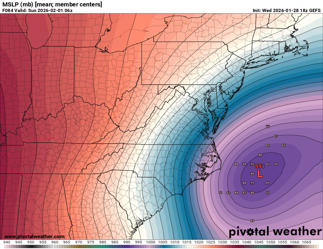
still a lot of uncertainty with respect to the placement of the low will need to see how this plays out, but I genuinely think there's an outside chance those numbers we are currently seeing over NC end up over Richmond (of course there is also a higher than usual chance of a total fail)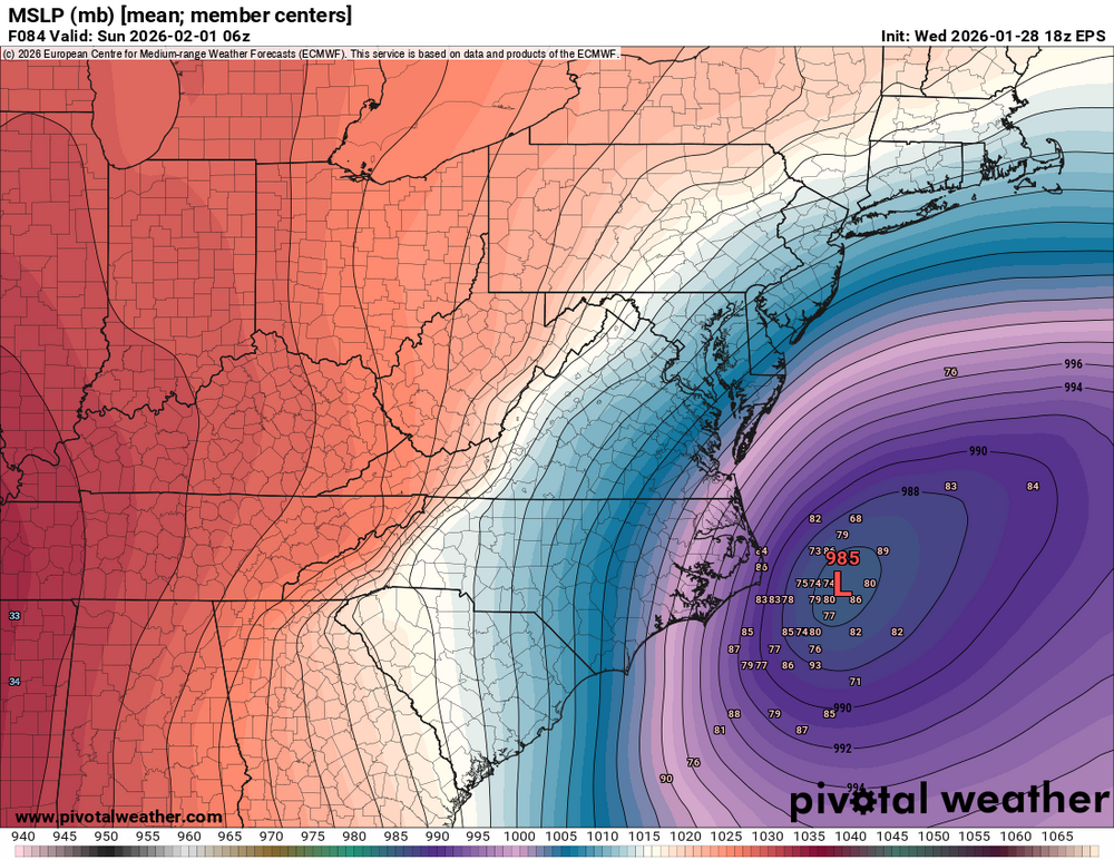

-
Richmond Metro/Hampton Roads Area Discussion
Ephesians2 replied to RIC Airport's topic in Mid Atlantic
not only that, ULL driven snow can have high ratios. you can have mid ratios with very cold temperatures. (our ratios with the front end of this last storm were pretty bad) BUT if you get snow from the ULL pass or the back end of a coastal it can promote high ratio snow I verified 17:1 ratios with the ULL from the Feb 19-20 storm -
Richmond Metro/Hampton Roads Area Discussion
Ephesians2 replied to RIC Airport's topic in Mid Atlantic
WPC seems to be assuming a bit of a north trend -
The “I bring the mojo” Jan 30-Feb 1 potential winter storm
Ephesians2 replied to lilj4425's topic in Southeastern States
I'll be sweating that cutoff here. I hope NC does well, but I also hope I don't get fringed twice in a row -
Richmond Metro/Hampton Roads Area Discussion
Ephesians2 replied to RIC Airport's topic in Mid Atlantic
at 78h on the 18z GFS: more progressive and south of 12z clear step back -
Richmond Metro/Hampton Roads Area Discussion
Ephesians2 replied to RIC Airport's topic in Mid Atlantic
AIGFS drier and east of 12z -
Richmond Metro/Hampton Roads Area Discussion
Ephesians2 replied to RIC Airport's topic in Mid Atlantic
it sure would be funny if the GFS and Euro switched places again not saying that will happen of course -
Richmond Metro/Hampton Roads Area Discussion
Ephesians2 replied to RIC Airport's topic in Mid Atlantic
At 42h the GFS looks east of 12z at 500mb... -
Richmond Metro/Hampton Roads Area Discussion
Ephesians2 replied to RIC Airport's topic in Mid Atlantic
very consistent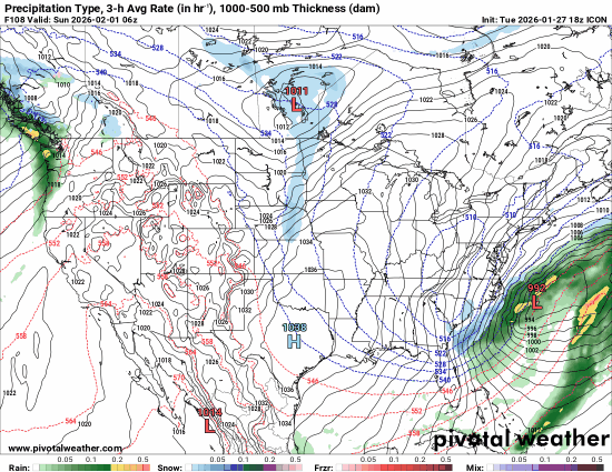
-
Richmond Metro/Hampton Roads Area Discussion
Ephesians2 replied to RIC Airport's topic in Mid Atlantic
ICON isn't going to be quite as atrocious lol -
Richmond Metro/Hampton Roads Area Discussion
Ephesians2 replied to RIC Airport's topic in Mid Atlantic
PNA ridge just a little bit east of ideal. it really is unfortunate how we have to get pretty much everything right to get snow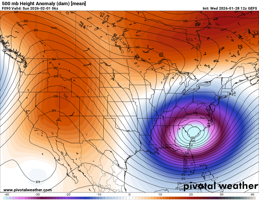
-
Richmond Metro/Hampton Roads Area Discussion
Ephesians2 replied to RIC Airport's topic in Mid Atlantic
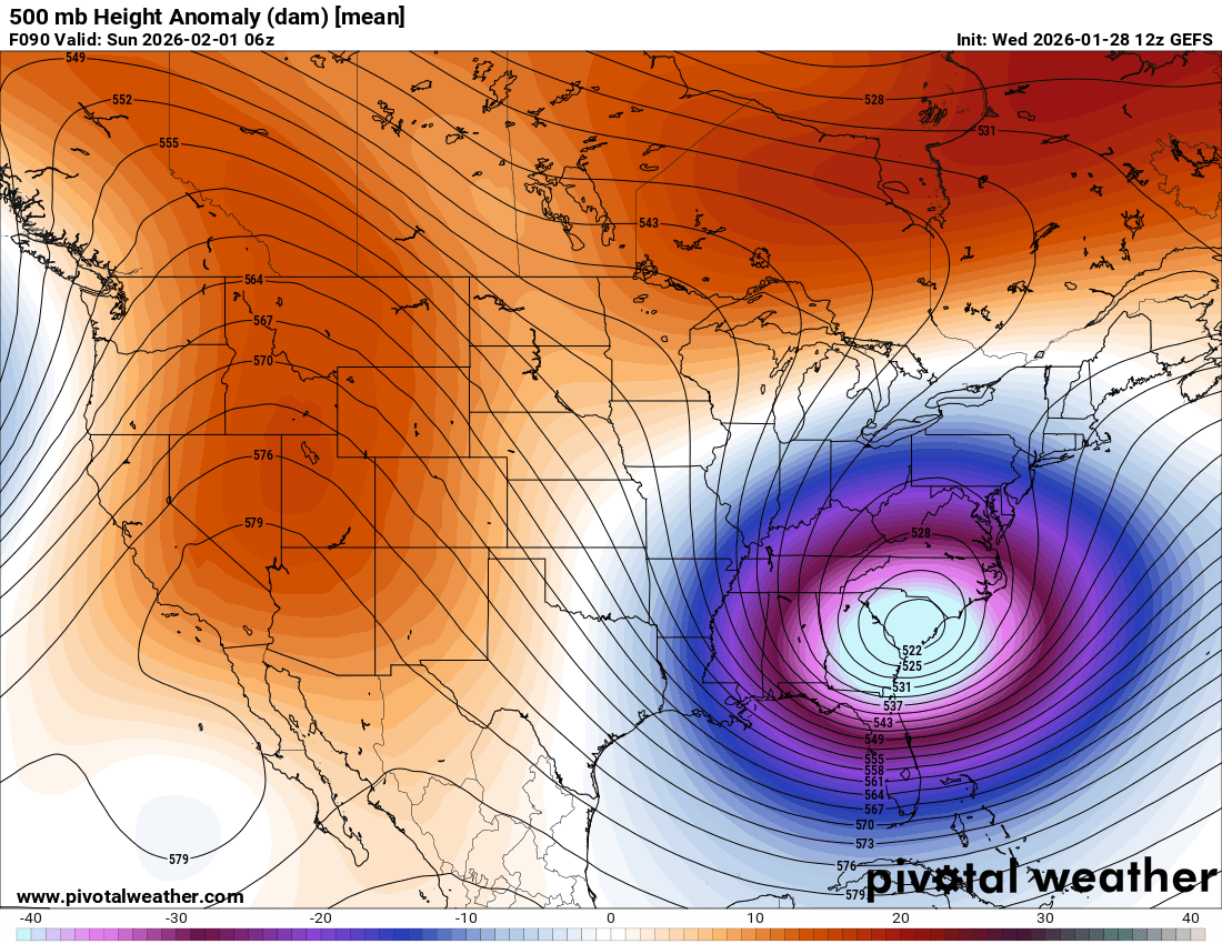
if the 500mb low was 50-100 miles north it would be warning level snow for everyone in this thread. I think we can get these types of adjustments in this window.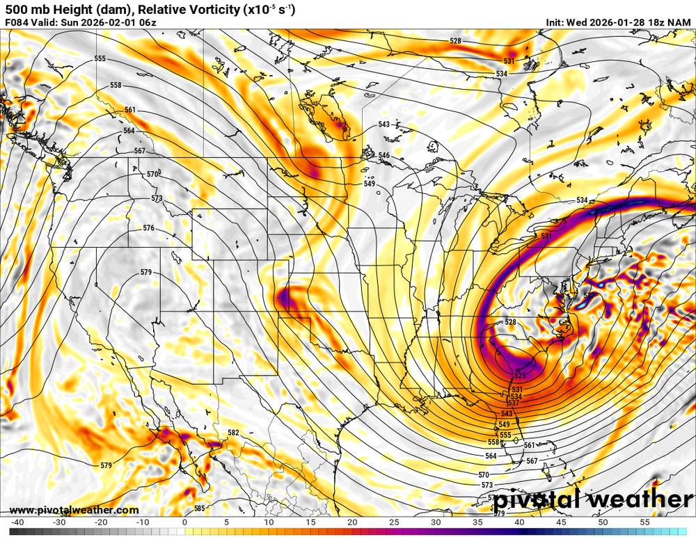
-
The Jan 31 Potential: Stormtracker Failure or 'Tracker Trouncing
Ephesians2 replied to stormtracker's topic in Mid Atlantic
if I recall, our area got a decent snow last february from a similar setup