vortex95
-
Posts
729 -
Joined
-
Last visited
Content Type
Profiles
Blogs
Forums
American Weather
Media Demo
Store
Gallery
Everything posted by vortex95
-
CoastalWx was mad I bet b/c GHG was in a relative mind for snowfall! He hadn't moved to Dorchester yet!!!
-
I think in MWN's case, the always prefixed their remarks sections w/ "RMK," so perhaps that why they were retained. Standard airport SAs did not do this. I have printouts from the 80s and 90s of many SA ob string from various U.S. sites when big wx was occurring. I'll take a look sometime and take pix of them. Even after the METAR format was adopted in 1996, WSI took the raw METARs and converted them back to SA format for our clients/customers, so I have digital file of obs strings of selected cool wx events. Ask CoastalWx about "Q62" for BOS concerning SAs!
-
Did not know TS occurred w/ the May 1977 event. I wish these obs were also archived in the original SA format. Also, all remarks were lost for some reason when they converted the SAs to METAR format. Those were the best part! LTG obs and SNOINCRs, among other things.
-
Thanks! I just noticed the other sections for the May 2002 and Oct 2020 events. I have snowfall map booklets from a private wx company I worked for in the late 80s/early 90s that lists all snow events from the 1970s to the mid-1990s. Let met dig those out of storage at home and I'll give you a list of the more significant ones. Here's one from Mar 22, 1977 I can recall offhand. A blockbuster coastal storm lashed New York and New England. Norfolk, Connecticut was buried under 33 inches of snow. 24 inches was reported at Pittsfield, Massachusetts and 18 inches piled up at Gardner, Massachusetts. Snow amounts exceeded 30 inches in the Catskills in southeastern New York. 3 to 5 inches of rain deluged south coastal New England and wind gusts reached 60 to 90 mph. A 450 foot radio tower in Framingham, Massachusetts was toppled by the high winds. Oh and this one! Oct 3-4, 1987 A rapidly deepening coastal storm dumped record early snows in eastern New York, western Connecticut, western Massachusetts, and southern Vermont. Grafton, New York was buried under 22 inches and Pownal, Vermont recorded 18 inches. This was primarily an elevation storm but even Albany, New York received 6 inches of very wet snow. Damage to trees was extensive since many of them were still in full leaf. Road crews had to scramble to get their plows on as the snow caught everybody off guard. Not sure if you include very localized events, but this is one of the most impressive NORLUNs in SNE in the past 35 years. Feb 19, 1993 Intense ocean effect snow squalls buried Chatham, Massachusetts under 20 inches of snow. Snow fell at a rate of 4 inches per hour for 3 consecutive hours. A "NORLUN" instability trough was responsible for this event.
-
Ok, looked it over. I realize getting data for events long ago is not as easy, but here's a list of the "biggies" in the 80s (not that there were many!) that you could add when you have time. Dec 5-6. 1981 - big bust as the storm was fcst OTS April 6-7, 1982 - powder blizzard in April! Mar 29, 1984 - nasty wet paste bliz, among the worst power outages for SNE on record for a snowstorm, G108 mph MQE and tons of TS+ Jan 2, 1987 - the "syzygy storm" w/ big storm tides that breached the barrier island in Chatham Jan 22, 1987 - worst traffic gridlock in SNE since 1978 Jan 26, 1987 - Cape Cod bliz only #1 Feb 9-10, 1987 - Cape Cod bliz only #2 Apr 28-29, 1987 - poorly fcst late season crushing Nov 23, 1989 - big surprise Thanksgiving snowstorm Others: Feb 24-28, 1969 - "100 hr snowstorm" Jan 20, 1978 - bliz #1 w/ 24 hr snowfall record for BOS to date Dec 11-12, 1992 - the blockbuster that started the epic snow period 1992-93 to 2015-16 May 18, 2002 - latest accumulating snow on record for many locations in SNE Oct 30, 2020 - BOS biggest Oct snowstorm and also many other areas far E/SE MA
-
Awesome. Will share w/ other mets I know!
-
Where is your photo of you standing w/ such uber pride in it all!
-
But I have heard so much from you over time about the Bliz of 05!!!!
-
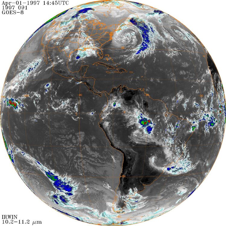
But nothing takes the cake for CoastalWx than the Bliz of 05. Scott has the radar loop archived for that I think! So which is it for you, Bliz of 97 or 05? Does Bliz 13 round out the top 3 for you? From both a meteorological set up and personal experience event, the Bliz of 97 takes the cake for me. Why? 1) Being so mild that weekend leading up, and strong tstms later on Sat across SNE. Then a pleasant Easter Sunday for the region w/ temps in the 60s. That just makes the stark contrast to what was coming even better, It is the "let's freak out the general public as much as possible" wx swing! 2) I was off on Monday, and I recall the forecast was not for a flip to snow until later in the aftn. Yet it started as a R/S mix in Woburn MA at 1030am. I was like "oh boy...." 3) The struggle for accumulation during the day due to marginal temps. I had 4" but it was only on certain areas, like on the car top or mulch. 4) Then as night fell, remarkable transformation occurred. I went out at 6pm for some errands, and it was not too bad, by the time I finished them by 8pm, it was nuts. Temp dropped from the low 30s to mid 20s, snowfall rates 2-3" hr, and blowing and drifting everywhere. Even the 128 was a total mess. I could see transformer explosions in the distance. Got home and then a brilliant LTG strike. And the poundage continued. Got 4" in one hr 2-3am. You'd never think it was April 1 w/ what was going on outside. 5) My car was completely drifted over the next morning. Never had I had that happened before. 6) BOS struggled R/S mix all day into the early evening, and then BLAM!, went to S+ right around 00z, and they got 25" in about 12 hr. I really think that BOS had it all-time record snowfall w/ this storm, but access and drifting issues prevented the observer 1 mi away from Logan that took the airports obs at the time from getting an accurate measurement. 7) BOS DPW was taken by surprise by the rapid flip to S+ that evening, and the rates were so crazy, the city was snowed in bad, and some part of the city remained unplowed for 3 days. I recall I front page story from the BOS Herald, and it said "TICKED OFF" and showed a resident hold a clock 1201pm standing in his unplowed street, stating the city promised his street to be plowed by noon (still had the paper). 8) The satellite image morning of 4/1...absolutely epic. I attached it. Look at the enormous size of the storm, and how far wrapped it was with a classic giant mesh of instability CU over the ocean! After that, I said to myself, I've got my fill for big snowstorms. Since it had been so good since 1992-93, I was "sated" so to speak. Nothing could top this event on multiple levels as I noted above (not all meteorological). Not that I did not enjoy what happened later as the epic period continued, capped off by the crazy Jan-Feb 2015 snowblitz, but I no longer got "CoastalWx mad/in a snit" when snowstorms did not work out, or mild/snowless winters occurred. All my hardship from the lame winters of the mid 80s to early 90s was excised, so to speak, after the Bliz of 97. Maybe CoastalWx should take note of this, and not get so miffed when winters do not cooperate! Not like you've never experienced epic winters, and 1991-2020 was the snowiest 30 yr normal period for much of SNE on record, w/ truly an exceptional snowblitz Jan-Feb-2015, unlike anything on record for SNE. This does to mean I do not welcome big snowstorms and get into weenie mode when one is imminent, but there is more to wx than that. And really, it nice to have breaks sometimes! Also, always swinging for "home runs" (blockbuster snowstorms) you are going to be disappointed very often. Who needs that emotional roller coaster from something no one has control over?
-
Awesome snow maps. On your site, how many have you done, and how far back?
-
Yes, I know, but enough ppl has access or were looking at AFDs outside mainstream media to run w/ that and hype. Yes, this was long before FB, Twitter, and tidbit quotes going viral instantly, esp. to the general public. But within wx circles, chat forums, and list-servs, this was a hot topic. I recall it well! IIRC, that March 2001 event was I think the first time the MSM went nuts 5+ days out for the "storm to end all storms" PHL-BOS. A watershed event for pre-storm hype! The big cities largely missed out, even BOS, but just 10 mi NW in Woburn, I had 23" of snow, and it was super wet that entire 23"! Never had I seen so high vertical snow "walls" on power lines (wind was next to nothing), and never has so much snow in a single storm that was 100% wet. You'd dig into the snow pack, and you'd see a blue tinge, esp. noticeable while it was still cloudy That's when I learned that high-moisture content snow result in this. So "KEWL!"
-
So 11" in an hr from combined upslope and convective TSW++? Probably giant dendrites! Good info. Knowing the limits of any wx event, type, or specific phenomena is paramount for historical discussion and getting people excited!
-
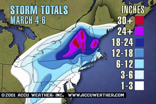
"Will exceed?" That is unwise to forecast an all-time record storm w/ absolute wording. It is so hard to say "may approach?" That is the more reasonable thing to do, rather than go all out. This sets one up for big failure in the eyes of the public if it does not happen esp, when comparing it to a benchmark storm for a region. The psychological impact here is huge. Was 40-50" explicitly forecast by any model for parts of SNE? Were storm tides forecast to match or exceed the Bliz of 78? Was there a 1055 mb high in place NW of New England w/ a 70 mb plus high/low difference? Was the synoptic pattern over NAMR similar to the Biz of 78, b/c that 500 ridge/trough evolution was exceptional, unlike anything in the KU cases. You not only had a massive cut-off low form just S of New England, but a massive cut off high form at the same time over western Canada. The worst case scenario is the least likely to happen in any given storm situation, so you better have a darn good reason to go for it. The notion "better safe than sorry" is a tired and invalid excuse. Going for worse all the time has real world consequences and impacts, and you will be wrong more often than not. Extraordinary events require extraordinary circumstances.
-
Wow, never heard of that outside of LES or Rockies/Sierra-Nevada upslope. Ayer MA has 8"/hr on 12/23/97 and the 12/9/05 was up to 9"/hr near Andover MA. So was it on the mountain at Sunday River at 3000 ft?
-
Supposed to?? According to who or what? Did all models show 24-30" for NZW or did you just pick the one that showed the most? Scott gets over a foot and still complaining? So when Hamden got 40" in the Bliz of '13 and you only got what, 26"? You were mad then as well? Talk about spoiled. I WANT THE MOST ALL THE TIME!!!" Recently get buried all-time in Jan-Fen 2015 and 2 years later still complaining. Coming soon, "the ratios were 'supposed to' be 20:1 and were only 12:1! So I "lost" and for `12" instead of 20"!
-
Great snowfall maps!!!
-
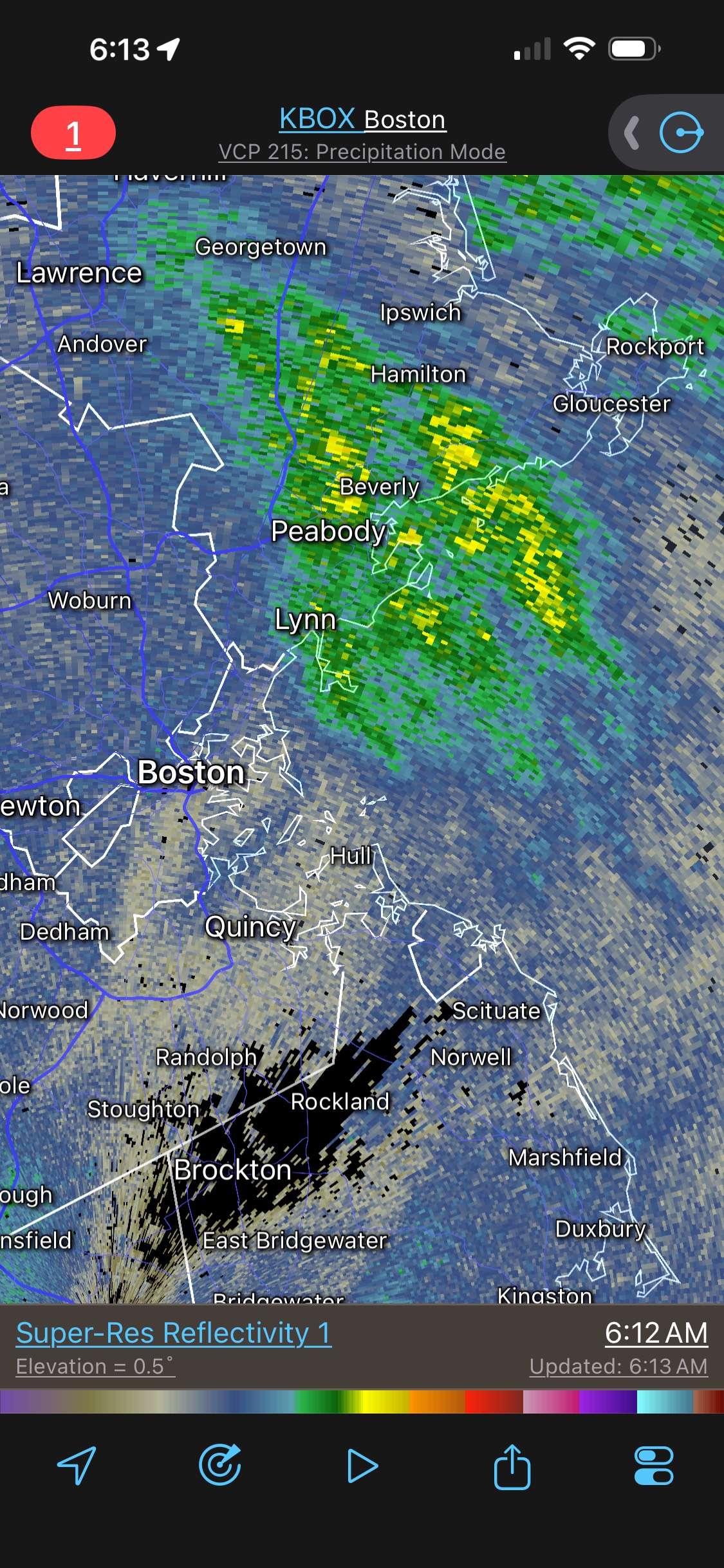
Friday February 6 FROPA / WINDEX small event
vortex95 replied to HoarfrostHubb's topic in New England
Saw 5.5" in Weymouth as of 5pm for the max in Norfolk Co. WUZ that U? -
Friday February 6 FROPA / WINDEX small event
vortex95 replied to HoarfrostHubb's topic in New England
For Weymouth/CoastalWx, "WE HOLE!"
-
Friday February 6 FROPA / WINDEX small event
vortex95 replied to HoarfrostHubb's topic in New England

-
Friday February 6 FROPA / WINDEX small event
vortex95 replied to HoarfrostHubb's topic in New England
We BIG snow! Probably the most 40"+ reports in a NEUS storm other than March 1888 and Feb 1969.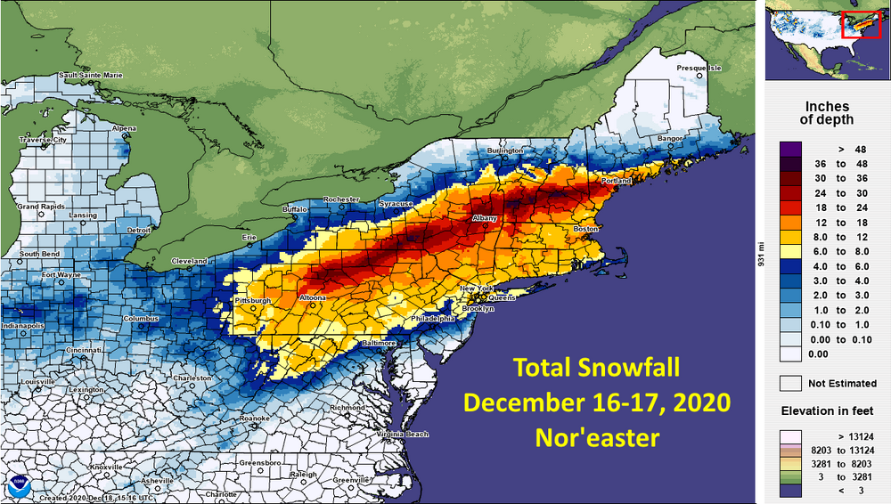
-
Friday February 6 FROPA / WINDEX small event
vortex95 replied to HoarfrostHubb's topic in New England

-
Friday February 6 FROPA / WINDEX small event
vortex95 replied to HoarfrostHubb's topic in New England
"I WANT MORE!!!!" LOL. -
Friday February 6 FROPA / WINDEX small event
vortex95 replied to HoarfrostHubb's topic in New England
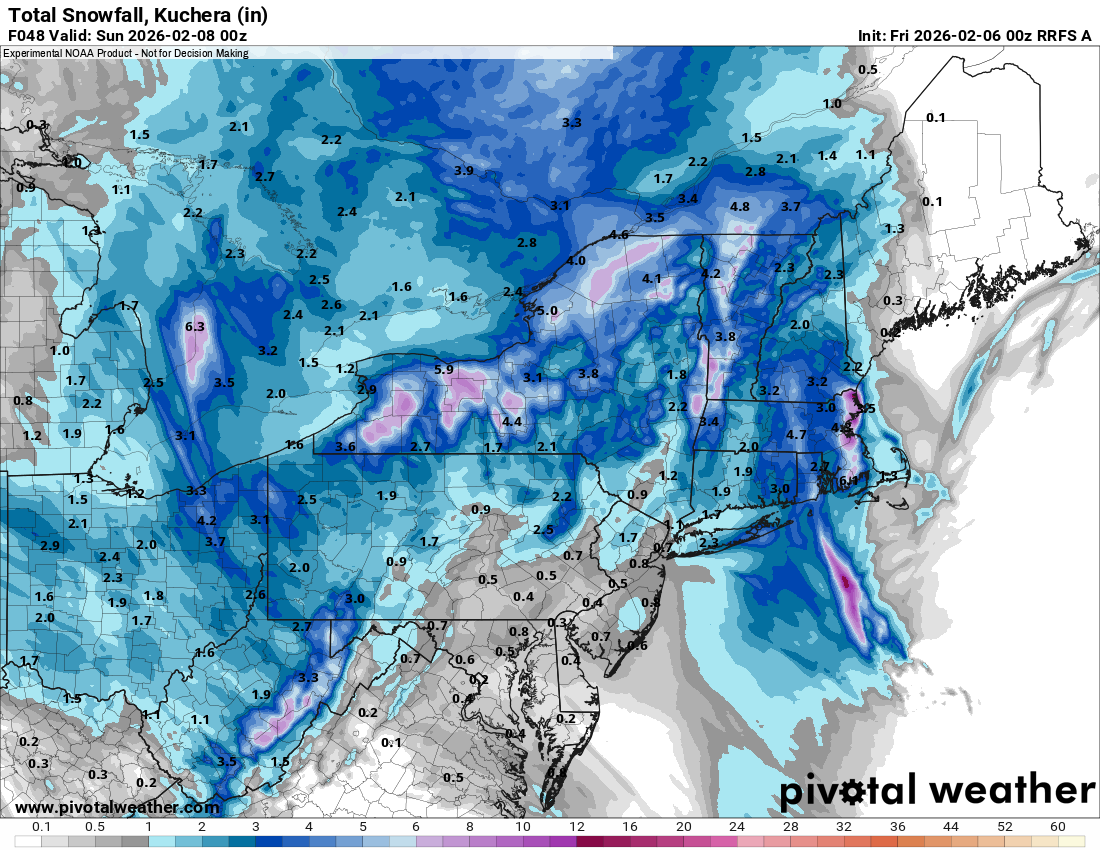
I know what CoastalWx is thinking now w/ the 00z HRRR -- March 8-9, 2013! Not quite the 600 mi SE of ACK the sfc low was then, but it still 300 mi! 30" at MQE in the 2013 event. One of biggest modern day fcst busts here for snow! The 500 low elongation axis is now just W of the region, and the low cuts off a decent distance S of LI on some models. So a weenie pseudo "backlash" OES combo appears likely. -
Given how crappy the previous 4 winters have been, this winter has been outstanding. We can't always have a 1992-93, 1995-96, 2004-05, or 2014-15 every time for a "good" winter. CoastalWx mindset: "If it is not a Bliz of '13 RIPPER w/ everything but the kitchen sink falling out of the sky, I'm dissatisfied!"
-
Friday February 6 FROPA / WINDEX small event
vortex95 replied to HoarfrostHubb's topic in New England
It's PT time for CoastalWx! RRFS FTW! Such a slow evolution of the 500 trough over New England Sat-Sun. It just doesn't sweep though, it elongates and cuts off for some really good OES weenie bands IMHO. 500 temps drops as low as -38 C, which is about as cold as you will see them in the NEUS. -40 C at 500 in the CONUS does not happen too often, and I think the limit at 500 for temps is around -50 C (coldest I have seen in NAMR is -51 C). There is some physical atmospheric reason why it can't get colder than this I recall, but I forget the reason why.