vortex95
-
Posts
2,208 -
Joined
Content Type
Profiles
Blogs
Forums
American Weather
Media Demo
Store
Gallery
Everything posted by vortex95
-
Be more specific. Let me put it this way, if NNE gets a foot plus and @dendrite is walking in "white gold," and Weymouth is all rain, you are just as mad as if no storm occurred at all!
-
Well that's part of the issue overall w/ you. Beggars can't be choosers. Now, I guess we can say for @CoastalWx "if it is not a Miller B, who cares...MEH!" And what about the ones that don't "fit?" Dec 9, 2005 for instance, Or the early March 2013 "surprise" event? How about the 100 hr snowstorm late Feb 1969? Oh, wait, "the BOS 26" fell over 100 hr. It was all S- w/ sucky dendritic growth w/ an avg snowfall rate only 1/4"/hr -- WORST EVA!" Meanwhile, in @dendrite country, 50"+ falls!
-
"I HAZ?"
-
"Yah but" you do not have to be concerned about the storm developing "too late" or any issues w/ moisture. You do not even need a strong sfc low and still get crushed. Jan 20, 1978 is a classic example. Gave BOS is biggest 24 hr snowstorm up this time.
-
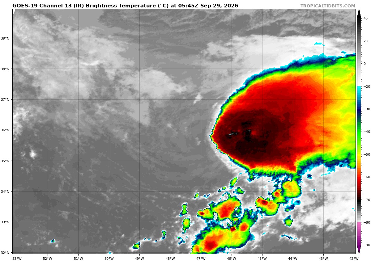
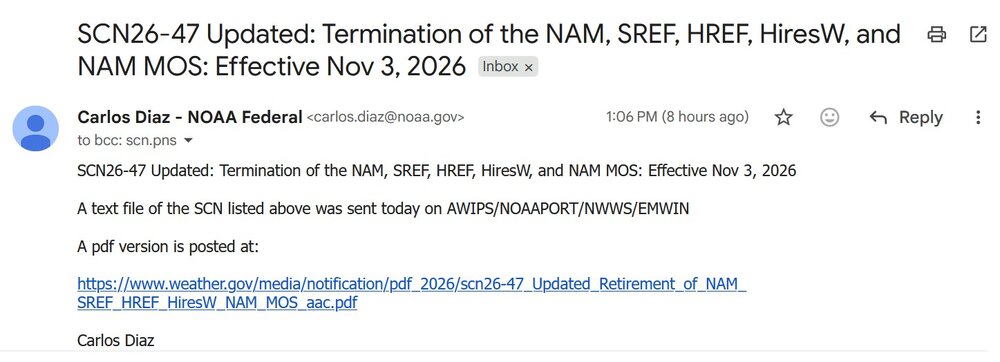
Looks like @CoastalWx gets to keep his beloved NAM a little longer! As for his "garbage" model (RRFS), it does appear to have issues w/ making deeply occluded lows into TCs too easily. It did that for the most recent storm. But non-TC CAMs usually do.
-
2026 Atlantic Hurricane Season
vortex95 replied to Stormchaserchuck1's topic in Tropical Headquarters
Since operational intensity was borderline and it's not really a sampling issue, I don't really see how they would bother. I mean, that's not overwhelming data for reanalysis to circumvent the operational intensity, IMO. Lots to consider in this case, and given the dearth of HUs this season, I hope focus on Fay by NHC is not overthought or nitpicked if we do not have any clear HUs for the rest of the season! I am just thinking external pressures that can hurt the objectivity of the met science here (e.g. social media making a stink or crying foul w/ armchair mets and hype-masters going off!). ASCAT has issues in heavy rain areas leading to a high bias. And in convective area that pulse when downbursts are more likely, that is an issue. On that ASCAT image provided from the X link, it is a very small area of 65 kt winds, that can suggest a mesoscale transitory feature., Also, I have seen it noted that Fay had an eye briefly. That was more dry slot residual b/c leading up to that appearance you could see a narrow band of dry air curling into the center. This dry air present also promotes pulsing convection and downbursts. That's one thing I have found questionable at times for assigned intensity. Spot winds are not the same as mean winds. Local convective winds are not the same as avg synoptic gradient winds. Many moderate to strong TS briefly have HU force winds from localized intense convection that pulses in blobs, esp. when some shear and dry air is present, but that does not make them a HU. So one has to be careful here. Sometimes I see "given the possibility of undersampling." That is a slippery slope IMHO. You can always say that in measuring meteorological phenomena, but does that mean you always say it was stronger and go higher? If so, what is the limit as to how much stronger? It is subjective and fluid. Dvorak classifications for TCs do best for winds approx 60 to 105 kt, so that means TDs are often min TSs and intense HUs are often stronger in reality. We know this from recons, but in the absence of recon, we don't officially assign a stronger value due to the limitations of Dvorak. It's why you will not see a system above 160 kt in the Atlantic or eastern/central Pacific in the absence of a recon. Best you can say w/ high confidence is that it was at least this strong and mention "it could have been stronger" in something like the TCR given any number of ancillary factors that can exist when it comes to determining TC intensity. A SAR pass showed 73 kt for Fay, but this remote sensing tech has been shown high bias here as well compared to recon measurements. -
@CoastalWx wants one? Pad his yard snow totals? https://www.powder.com/news/ski-ward-begins-snowmaking-september
-
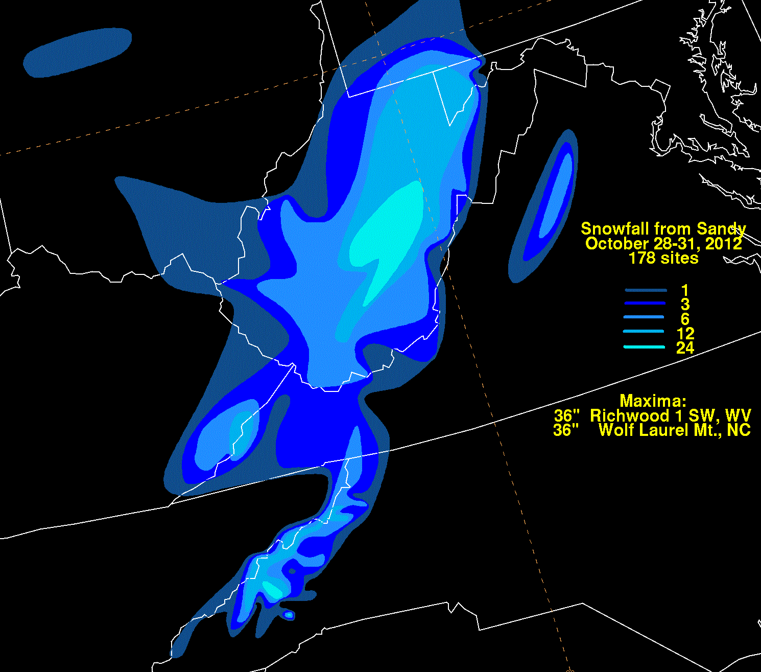
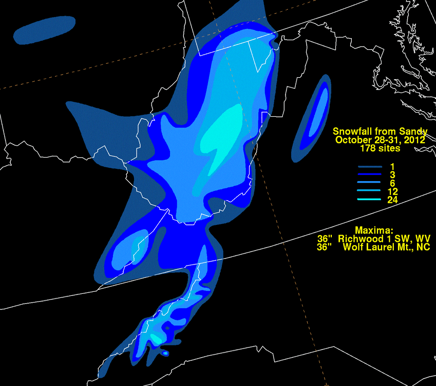
We need more Miller Cs! Apparently, those are Sandy-type systems. Hazel in 1954 and 1938 fall under that. However, I have been unable to confirm if "Miller C" is a thing officially, but these are unique -- those systems that get a big boost from a TC phase and the TC itself gets the best of both worlds, derived energy from baroclinic and SSTs so they can remain atypical strong much farther N than you'd expect for a TC in our region. Sandy buried WV up to 36" and up to 48" in VT from the 1804 hurricane and Ginny in 1963 w/ 13" in ME. Double PT for @CoastalWx here!
-
Feb 1983 and March 1993 would disagree w/ you. I say we make a Miller "W" -- those storms that give the max S+ to w/in 5 mi of Weymouth only! Miller As can really tease the Mid-Atlantic weenies, esp. once you get S of DC proper. How many times does it show 20"+ for RIC, and it ends up 3-4" of IP? We don't have that high 1000-500 thk/very cold 850 issue "DA MIX" really in the NEUS.
-
In the next week, given Rachel and Nolo will be around for some time, we should make it to #2 for most ACE in an E/CPAC season.
-
2026 Atlantic Hurricane Season
vortex95 replied to Stormchaserchuck1's topic in Tropical Headquarters
1983 was weak La Nina, so it shows the range here. El Nino is not required for a strongly suppressed Atlantic season. Given there are at least a dozen other oceanic/atmospheric oscillations going on globally at any one time, their phases and how they interact obviously are a factor. ENSO just is the most famous and the most influential globally it seems 1983 had one MH that hit HOU directly. One thing though that is consistent w/ suppressed seasons, the TCs, even the strong ones, are often quite small.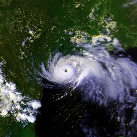
-
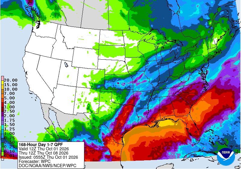
7-day WPC total pcpn shows what one would expect in strong El Nino. However, i do not see any signs in the next week of the STJ dominating or emerging. Miller As will be our SAVOIR this winter!
-
-
If the 850 is NOT -20 C and below and 500 heights below 500 dm, @CoastalWxdoes not want to hear it! You'd be surprised what shallow "fake" low-level cold can do, so don't diss it!
-
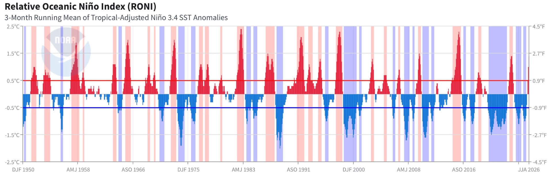
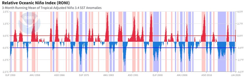
Good point about 30-year "normals." That period is arbitrary and we just decided to pick that as a base b/c it fits w/ human lifetimes as to a "long time," and the ever present recency bias, meaning what is going on now and recent *is* how it always has and will be. From a long-term climate and geological POV, that is nothing and not representative at all. Proverbial drop in the bucket. For instance, a full AMO cycle when it comes to Atlantic TC activity (up and down) is 50-90 years based on TC activity going back to the mid-19th century, so 30-year normals fall flat here. How about base conditions when it comes to ENSO? In the last 30 years, the base state of ENSO has become more La Nina (see RONI graph attached). Before that (going back to 1950), it was more El Nino base, but given we do not have enough or accurate measurements overall prior to this period to fully quantify ENSO states, we do not know the full cycle here, let alone if there is coherent one. So again, 30-year normals fall flat. Also, when calculating changes over time, I have seen some manipulation to give desired results. For instance, I saw a current temp anomaly plot for Australia from the BoM, and it said using normals 1961-1990. Well, you see the issue here, given mean warming since 1850, using normals farther back will give you greater temps anomalies to current. So what is the "correct" base reference here as to what 30-year normal period to use historically? Why not a 40-year, 50?, 100? And using the Industrial Revolution as a start point as if this point is what is "normal" for the globe overall? That is ridiculous and cherry-picking given the geological record. There are not only Milankovitch cycles, which work in the 10,000s of years, but also there are shorter solar cycles w/ the Sun -- Bray (~2500 yr cycle) and Eddy (~1000 yr cycle). So again what is "normal" can not be determined in just 30 years. It is square pegs round holes. And yet another factor, how standards/practices/technology change over time. One of the most obvious in wx? What we call a TC now vs. decades ago, which makes it looks like the numbers of named storms is steadily increasing. And not to exclude snow weenies, how about this? https://news.ucar.edu/14009/snowfall-measurement-flaky-history For temp, it used to be glass bulb thermometers, now it is largely digital. One thing about digital is that is can record continuous temps, and thus you can start doing calculations in many, many time periods. It used to be hourly for a day, but now you can go down to the min or even more. When calculating avgs now, you can pick and chose and each one can give different results. Also, digital can record instantaneous spikes in temp. Yes, ASOS uses a 5-min temp avg, but not all temp sensors out there do this. So more absolute extremes in temp are recorded, and this influence record temps for a given location, and sometimes are used new records when it is local artificial heat source contamination.
-
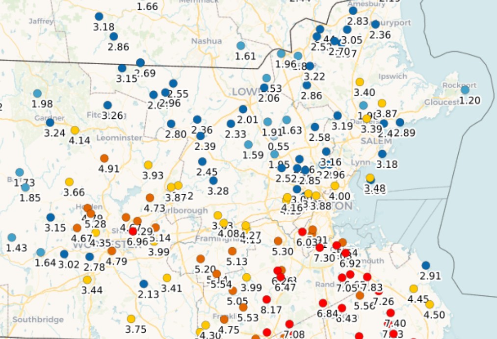
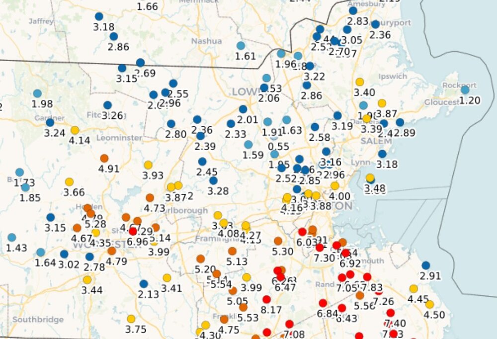
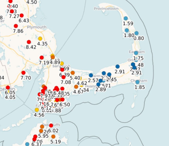
So highest I can find is 8.73" at Blue Hill. Any higher reports that did not make it into the PNS? The pcpn gradients are all over the place. N Shore to S Shore in MA? Ern CC to wrn CC and ORH Co? Seems like frictional convergence played a role as coastal location were low (Rockport 1.20" and Scituate 2.91") and increased not that far inland. Given the entire event was banded pcpn spiraling largely E to W, this makes sense. Imagine the anguish some would be having here from royal screw zones if this was snow and seeing epic amounts not far away. And for once, the max was within 5 mi of Weymouth!
-
Recall that time, I think in 2018, big rains on Cape Cod, and the dunes were eroded from rainwater flowing into the ocean! You thought that was funny.
-
Did not have much "cleaning" of the trees after Gloria in 1985. Bob did some in 1991, but only in RI/sern MA really. The only real big tree cleanings in the 90s and massive power outages was the early Dec 1996 1-2 punch (only time I have seen two discrete strong nor'easter back-to-back in 2 calendar days here!) and then the ice storm in Jan 1998. Then nothing that big until the Dec 2008 ice storm and then we really got some "house cleaning" events since w/ a cluster into the mid 2010s. @CoastalWxcan't stop talking about the GHG tree damage from the Bliz of 13! But a true widespread cleaning is still lacking overall. Need another Gloria or higher for that. Need to tax/pressure the trees inland w/ FQT G60kt and higher for several hours w/ leaves on the trees and an unfrozen ground. @ineedsnow be like "BRING IT ON!"
-
2026 Atlantic Hurricane Season
vortex95 replied to Stormchaserchuck1's topic in Tropical Headquarters
The 1961-1990 avg is 10.5 NS per year. The current 30 yr avg 1991-2020 is 14.5. In last 10, is it 18. Lots of factors. 1) 1970-1994 was an unfavorable phase of the AMO for Atlantic TCs. Since 1995, it has been favorable. 2) Many more short-lived TS that used to be not declared or missed now get a name and as late as 1994, an off-season HU was not counted/included. 3) Prior to about 2000, NHC rarely declared/included ST storms. Since that time, they declare them routinely. Also, from 1989 to 1994, there was only one operational GOES satellite for the U.S. and it was positioned at 98W So this meant no real coverage for the eastern Atlantic. Meteosat and polar imagery were available for this part of the Atlantic, but it was not received in real-time for hurricane ops. Another thing that changed is when the next generation GOES became available by 1995, not only did we have two GOES satellite again for better coverage, but also image resolution and frequency from these new satellites increased. And when we got to the next "next" generation of GOES satellites, launched in 2017, the resolution of imagery increased again and the amount of data per hour went up by more than an order of magnitude. For instance, we get a full disk every 10 min now. Prior, it was only every 3 hr. A CONUS every 5 min, It was only every 30 min prior. And we went from 5 satellite channels to 16. This all greatly enhanced our capabilities to track and diagnose TCs in real-time. Purely from a standards/practices and technological POV, you can't compare on a level playing field prior decades to the last 3 or so when it comes to NS counts. And this applies for the entire globe. A true long-term avg, accounting for AMO cycles, needs to be 50-70 years of high quality data. -
2026 Atlantic Hurricane Season
vortex95 replied to Stormchaserchuck1's topic in Tropical Headquarters
Every NS so far this year except Edouard has been significantly sheared during much of their existences. Hanna reminds me of Bertha, exposed LLCC w/ one giant "supercell" downshear! I say "supercell" b/c it is not a supercell in a traditional sense, but in the satellite presentation, it sure looks like one. Back-building convection upshear w/ discrete propagation.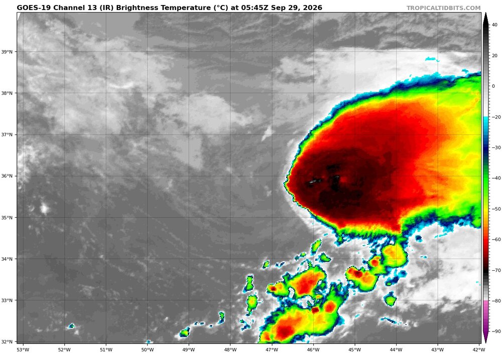
-
Good questions! Yes it would, but when you always go big or max, your fcst success rate for high-end wx event is 100%. That requires zero met skills. Anyone can say that and sound awesome! But ppl do it anyway b/c they know most will only remember the really big events selectivity, which is normal, but they do not realize such a forecaster always goes big, and this puts them up on a pedestal immediately and you get a dedicated fan/follower for life b/c of *one* "successful fcst of a biggie! Yes, "sneaky" wx events are becoming less common, but do not let your guard down, Ask @CoastalWx about Dec 9, 2005 or that early March 2013 snowstorm. And even though it would likely not happen in the NEUS, you still get HUs that unexpectedly go nuts those last 6-12 hr before landfall. Look at Michael in Oct 2018 and Ian in Sep 2022. And such unexpected RI w/ TCs happens at lot for far at sea. HU Nolo S of HI several days ago was fcst to peak at 105 kt. Well, it actually peaked at 135 kt! And Humberto in Sep 2007 near the TX coast in just 24 hr when from next to nothing as a disturbance to a 80 kt HU at landfall. Unexpected tornado outbreaks, esp. on a more local, less synoptically-evident scale, still occur every year. The "surprises" are more often w/ mesoscale-type phenomena these days (inner cores of TCs are mesoscale), but don't rule out weenie snowstorms/synoptic-scale events completely! And interesting combo is mesoscale surprises occurring when a large-scale synoptic event is expected. I can't recall the exact event (@CoastalWx will!) but there was an OES event in NE MA as a large-scale storm was approaching, and Topsfield got like 25" of fluff before any real synoptic snow moved in!
-
The biggest storm to impact the region in "HALF A YEAR!" LOL. Who says that in regular talk? Saying "6 months" is not dramatic enough, use "year" to make it sound "longer." You see how micromanaged wording is for max effect. This is good news from the Southern Rockies to the Lower MS Valley b/c this sig rain is badly needed b/c of drought conditions. You never hear about that, do you?
-
I am only a casual sports fan, so verify this for me. It has been said that its all about now the stupid drama OFF the field, like contracts, what this player said, a team potentially moving, etc, than the games themselves!
-
The way even basic TV services continue to increase in costs has become a major issue, and I have read that networks are pushing to be able to *charge* you for their station access, when it always has been free w/ antennas w/o cable. Yes, that would conflict w/ FCC regulations I think but never understated the power of lobby. The entire TV landscape is becoming a CF. Streaming was supposed to be the panacea, but now it is more expensive than cable w/ regular price increases way ahead of inflation. And for sports fans? Trying to find *where* your local or fav team will be on, not just when, is becoming absurd. Sometimes you do not even know the day before what streaming service/station a particular game will be on! And just wait until the SB becomes PPV!
-
Did you like the alkaline FOAM INVASION on the beach as the tide came in? I hope you didn't stand in it like reporters sometimes do...gross!