vortex95
-
Posts
2,211 -
Joined
Content Type
Profiles
Blogs
Forums
American Weather
Media Demo
Store
Gallery
Everything posted by vortex95
-
Enter August 2, 1975!
-
Odd statements like this that you would say, "no one ever says that!" or "says it that way!" are a red flag for AI-generated content. I've seen it many times in wx posts already on various social media platforms. One was talking about tornadoes and it said, "F5-class." First, not using the EF-scale is a red flag, and second, no one ever says "F5-class" for a pre-2007 tornado rating. We say, "F5-rated" or "rated F5"! In narration, it can sound great and getting all its facts correct, but you get thrown off whenever you hear a mispronounced word from AI not knowing usage context. Like "lead" or "wound." It stands out so much and it takes you out of the listening/learning part, and you immediately go, "AI SLOP!"
-
The door swings both ways, and neither far end is good! If one is going to cover wx for a big audience, state things objectively and try not to let personal bias sway you. Sadly, this position is harder and harder to find these days. And the most devious things about it is that some know better, are on the level, yet are well-aware that instigating conflict and divide w/ endless speculation, conjecture, and hedging is an easy way to get attention and monetize, so they disingenuously take this route. Some are more subtle than others. Look at the rhetoric and most importantly, how things are over time.
-
"If the wx is not *exactly* normal, then something is wrong!" The notion of normal is so messed up these days in public perception and in the field. Well, how about this to make ppl go ????? - "it's normal NOT to be normal! Normal all the time would be a problem in reality!" And ever notice that "not normal" is always associated w/ the negative? So how does one resolve atypical low tornado years or a quiet hurricane season? Or a winter than is rather mild in the CONUS, like strong EL Nino typically is? Heating costs and energy demand reduced alone makes it more beneficial than not.
-
40 at HIE on the latest GFS MOS. *Almost* a touch of frost!
-
You can see the mid-level center spin on radar near CRP currently. Talk about a tilted vortex sfc to mid-levels! This one of the most "disconnected" TCs I think I have ever seen. Great case study. The ECWMF handled this evolution very well. Compare its 925 mb RH/streamlines to its 500 mb RH streamlines, and the disconnect was fcst very well. This is about as far as you can get from a classic TC structure, but they exist on a *spectrum*. You can't use textbook examples all the time for what actually occurs in the real world. So both Arthur and Bertha were odd ducks, and even for sheared TC, more atypical for this variant of a TC. It also shows how the models still struggle w/ initial TC genesis for systems like this. Pre-Bertha was a non-tropical low that appeared it would remain broad and cold core, and strong shear was factor. Not that the models can't handle non-tropical to tropical transition, but the overall environment was not favorable, so that likely influenced the models. Yet the system still managed to form a large, solid LLCC in the mid 990s.
-
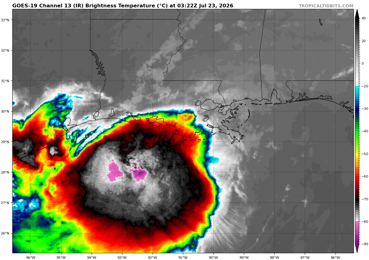
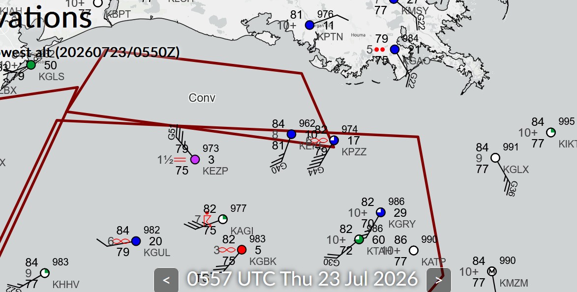
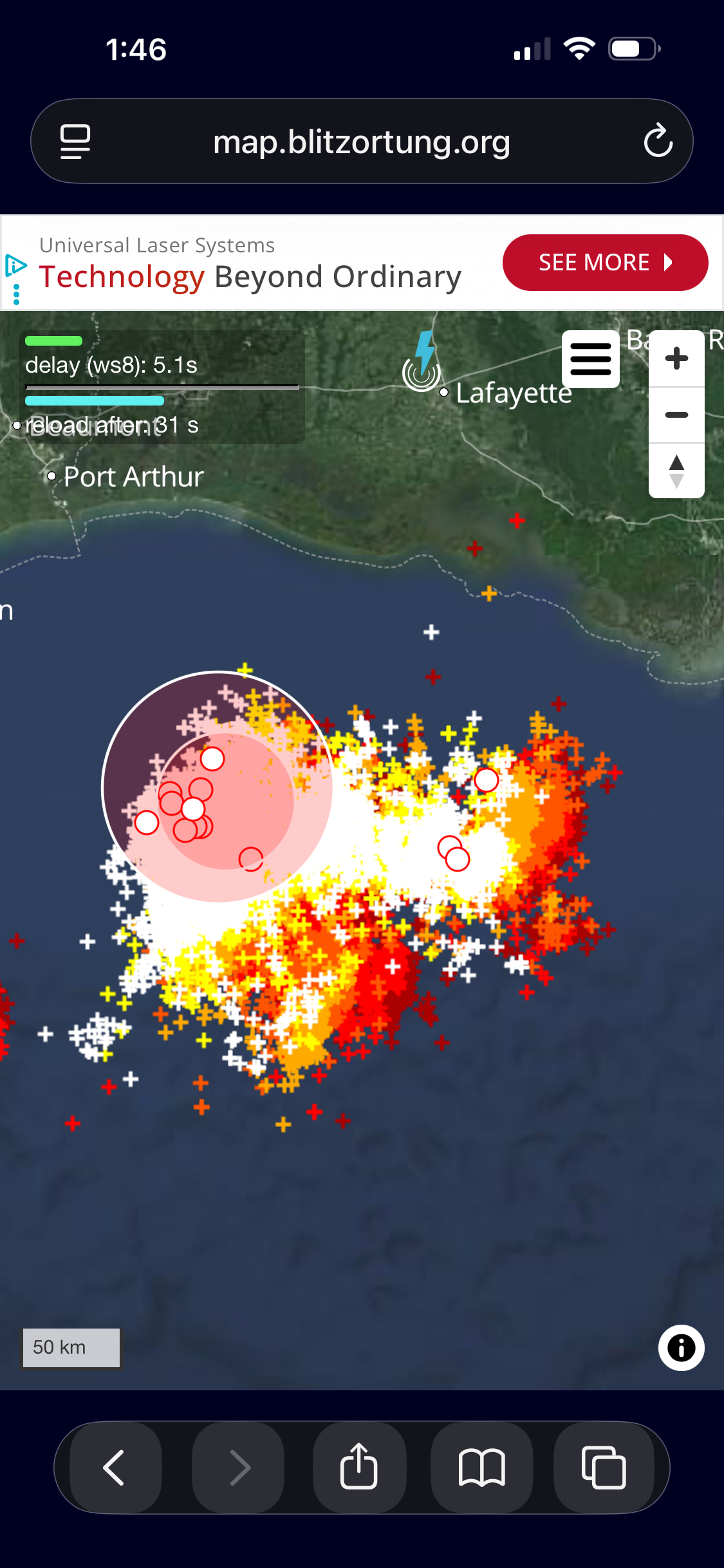
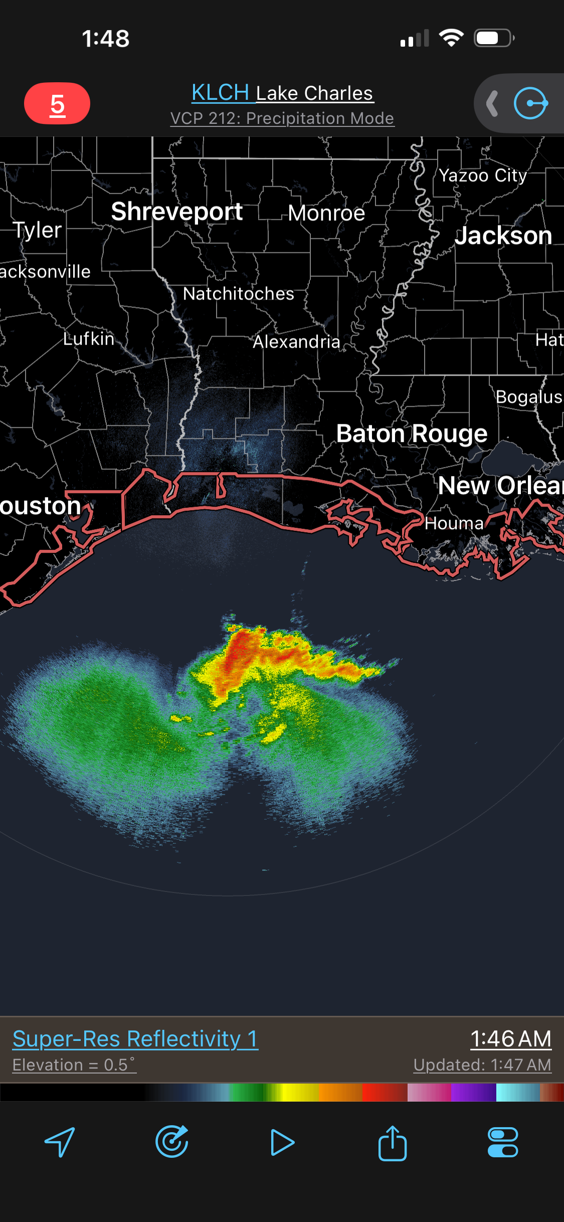
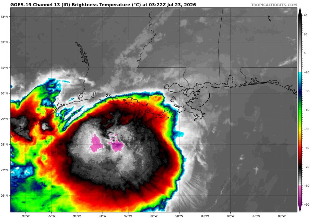
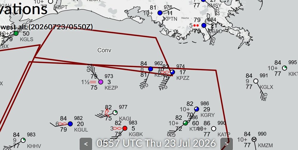
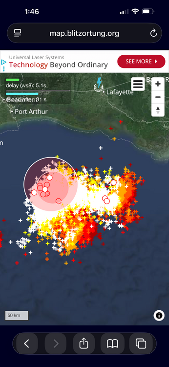
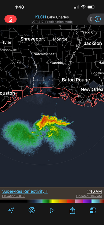
Now this is what I was talking about. Very intense convection b/c of the shear present. Cloud tops as cold as -90 C and an exceptional amount of CGs. Very dense. I attached a zoomed up image of the CG plot and it is still very dense! The strong shear in a tropical environment is promoting this intense convection. Looking at radar and then the EIR, you can see how these huge cold cloud tops are largely thick anvil w/ much small er precip areas under it. Basically like a MCC or a supercell complex! Platforms in the Gulf are showing something going on as to a center much farther S and some mesoscale phenomena. KEZP earlier had sustained winds of 65G71KT at a height of 75 ft. This is transitory in squalls (svr tstms basically!). Here are some platform obs from near the possible new center. METAR KEKE 230535Z AUTO 20024G40KT 8SM BKN010 BKN014 OVC028 29/27 A2962 RMK A01 METAR KEKE 230515Z AUTO 22009KT 10SM SCT011 BKN016 OVC027 29/27 A2960 RMK A01 METAR KEKE 230455Z AUTO 18006KT 7SM SCT011 BKN016 OVC023 28/26 A2961 RMK A01 METAR KEKE 230435Z AUTO 36007G12KT 3SM HZ SCT014 BKN022 OVC043 28/26 A2960 RMK A01 METAR KEKE 230415Z AUTO 31018G24KT 10SM SCT011 BKN017 OVC043 29/27 A2959 RMK A01 METAR KEKE 230355Z AUTO 31025KT 1 3/4SM BR BKN011 BKN020 OVC027 29/27 A2958 RMK A01 VIS 3/4V5 METAR KEKE 230335Z AUTO 32024KT 10SM SCT016 BKN026 OVC065 29/27 A2959 RMK A01 METAR KEKE 230315Z AUTO 32033KT 10SM SCT013 BKN019 OVC060 29/26 A2956 RMK A01 METAR KEZP 230535Z AUTO 32035G51KT 1 1/2SM BR BKN003 OVC030 26/24 A2973 RMK A01 METAR KEZP 230510Z AUTO 27033G41KT M1/4SM FG OVC003 26/24 A2972 RMK A01 METAR KEZP 230455Z AUTO 23042G55KT M1/4SM FG OVC003 26/25 A2977 RMK A01 METAR KEZP 230435Z AUTO 21065G71KT M1/4SM FG OVC003 27/25 A2965 RMK A01 METAR KEZP 230415Z AUTO 25040KT 2SM HZ OVC036 29/25 A2972 RMK A01 METAR KEZP 230355Z AUTO 29034G42KT 5SM HZ BKN039 OVC045 29/25 A2968 RMK A01 METAR KEZP 230335Z AUTO 30042KT 7SM BKN043 BKN055 OVC070 30/25 A2966 RMK A01 METAR KEZP 230315Z AUTO 30041KT 8SM BKN046 BKN060 OVC120 30/25 A2967 RMK A01

-
Sorry for the rant, here, but Wxwiz's statement deserves more detail using recent and further back factual history. El Nino is a lazy blame here. Can one really say this very wet period on South Coast on it? What about ern MA w/ its long-tern precip deficit and svr drought conditions? What happened to that? Did emerging El Nino conditions cause that as well? Going back to BDR record wet Julys that was posted earlier as an example, #1 is 1971 which was weak La Nina, #3 is 2021 and that was mdt La Nina. #4 was in 1988 and that was strong La Nina. Oh, but #2 is 2026 and strong El Nino is imminent, so that means it was the cause, esp. b/c it is in the here and now! Vapid and linear thinking. Are we to believe the El Nino singled out the South Coast and has left BOS high and dry, relatively speaking, and even more so NNE this month? What about how wet was in NNE the previous months and SNE was ripped of? Yes, BOS finally has an above avg rainfall month, but what, just quickly dismiss the long-term dryness that local media can't leave alone? Some ppl just turn on a dime here, whichever way the winds blows, and use the fact the public has short-term memory/attention spans. Also, El Nino direct effects show most in the winter for the CONUS, and most apparent for the precip in the subtropics this part of the globe. See the problem here? Some just make simplistic 1-1 correlations w/ nothing to back it up. Content on social media, and truth/facts be damned! Anyone can speculate, opine, or conjecture, and that's fine in itself, but too often these days it gets treated as fact or "will happen."
-
So the opposite of a storm surge! CoastalWx really gets into this "backwards erosion." Several years ago, this happened on Cape Cod, and he was like "what the...?"
-
What site gives the stats for climate location like this? Good stuff!
-
I recall in the summer of 2019, a friend of mine was driving S on I95 getting close to 128 junction, and he could see DSNT LTG in CB tops to his S. Turns out it was about 130 mi away over the ocean! Not often you see LTG that far away in New England, minus higher mtn tops. So I bet if it was night, you would have seen LTG in these CB tops! Farthest I have ever seen LTG in New England was about 15 years ago driving N mid-evening on I93 at the 495 junction. Saw a dull orange flash on the N horizon. Cell was close to BML, so about 120 mi.
-
More NW flow! And talk about the mean trough position remaining in the E! The 12z ECMWF gets really amp'ed in 7 days. So all sorts of convective possibilities, even if it is just big rains/lots of LTG! Type of pattern is that if we can get any TC development off the E Coast, odds are we can get at least its tropical moisture here. Some areas did quite well for rain ydy. Max I could find for the DC area was 3.75" at Highland MD. For SE VA where the biggest rains were fcst, ending 7am EDT, max of 6.00" at Kilmarnock VA (more fell after 7am). So the HRRR did ok, and RRFS overdid it, esp. over SE VA, but at least it had the location of the max rainfall correct. Still getting a feel for the RRFS. I've heard not so good things about it here and there, but it is still non-operational, so maybe it will be adjusted/tweaked by the time it goes operational in Oct.
- 2,604 replies
-
- 2
-

-
- severe
- thunderstorms
- (and 7 more)
-
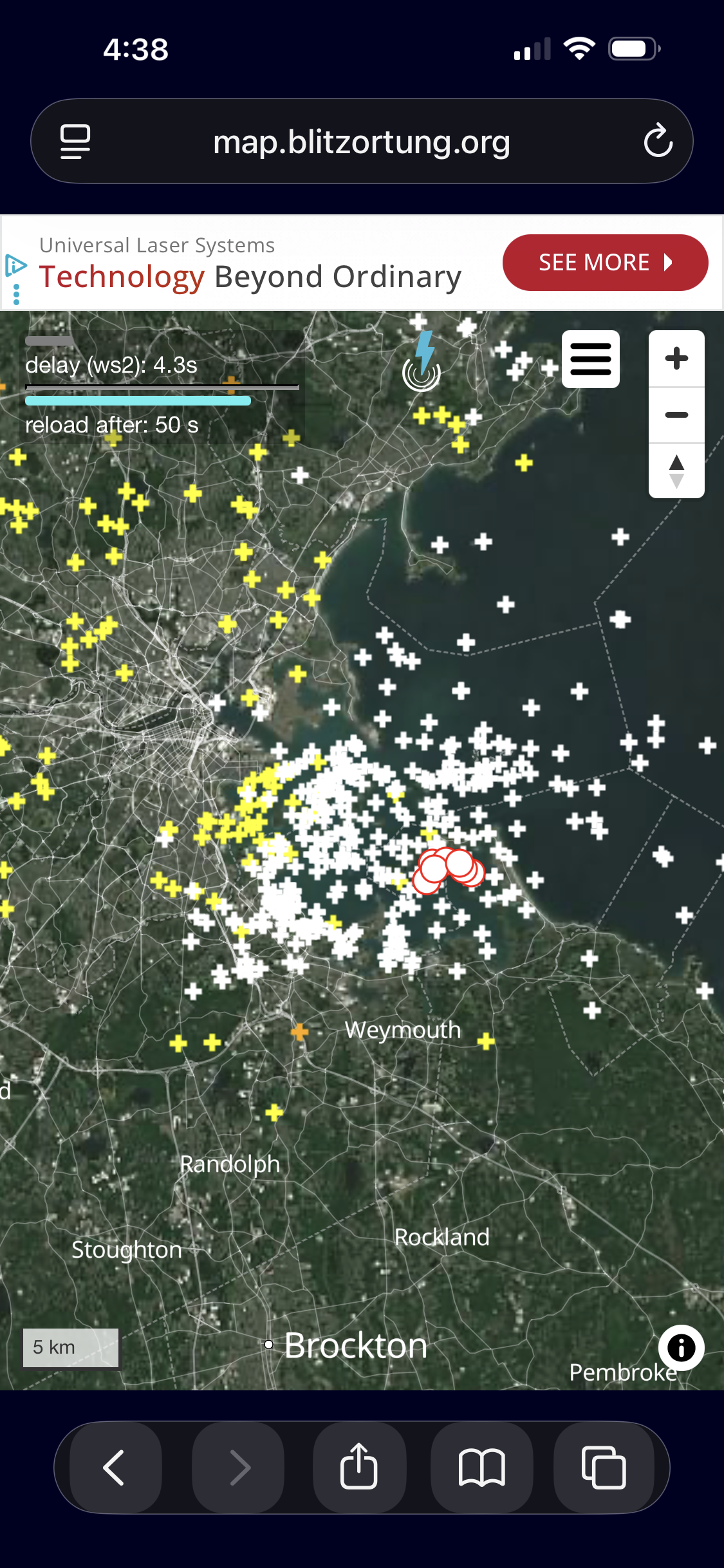
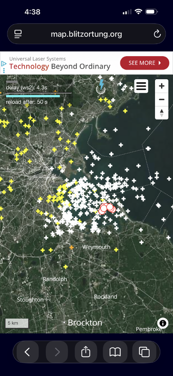
CG going nuts S BOS/Shore. CoastalWx is miffed he missed it!
-
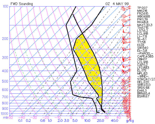
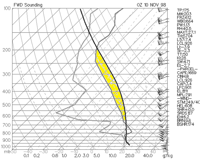
I am not versed in the exact physics of the processes, but I can say this. "Fat" CAPE on a sounding plot is not the same as "skinny" CAPE. "Fat" CAPE promotes more rapid updraft acceleration (image 1), and "skinny" CAPE promotes less rapid updraft acceleration (image 2). If you want svr wx, "fat" CAPE is more conducive to produce it. "Skinny" CAPE is better for heavy rainfall and flash flooding potential.
- 2,604 replies
-
- 2
-

-
-
- severe
- thunderstorms
- (and 7 more)
-
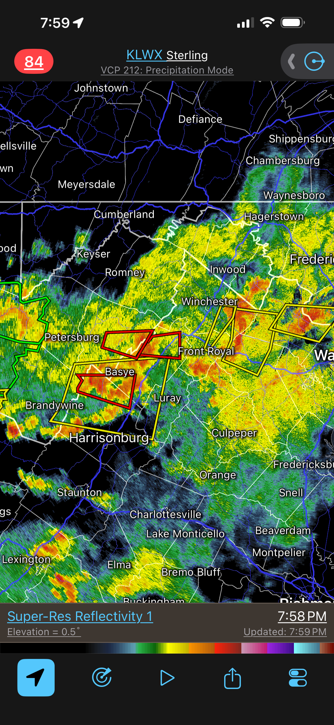
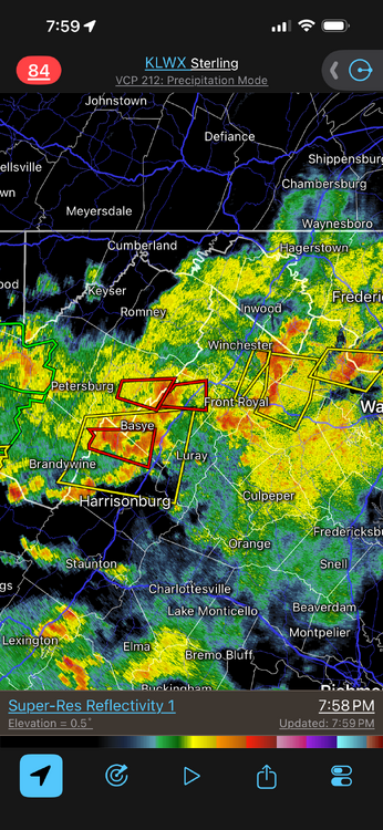
Are these things ever going to end today? TORs issued this late in the evening for an approaching cold front are not common these parts, but we are dealing w/ a rather strong 500 trof for summer and a decent 250 speed max in the area. And that's not something borderline either! Small but quite intense mesocyclone.
- 2,604 replies
-
- 3
-
-
- severe
- thunderstorms
- (and 7 more)
-
It is not easy b/c it depends on the CAPE distribution in the vertical column. In other words, you can't apply one updraft value at all levels of the atmosphere where there is CAPE b/c the amount of CAPE can vary a lot depending on the level you are at. Total CAPE does not necessarily tell the entire story as to full updraft potential. Yes, generally more the CAPE the better, but it does not always mean the same type of svr wx or even things like lightning frequency or most efficient rainfall rates. And CAPE (hence updraft potential) is almost never realized fully by a storm, b/c of 1) dry air entrainment and 2) precip loading. And it goes one step further. Updraft strength is also dependent on pressure perturbations induced by a mesocyclone. For instance, mesocyclones are typically strongest at mid-levels. So you actually have lowest pressure here. This results in dynamic uplift b/c of the pressure deficit aloft. Now, this is superimposed on CAPE that is present. A mesocyclone present can effectively double the updraft strength that would exist just from CAPE alone, which is why supercell updrafts are so intense. More CAPE down at low-levels is better for tornadogenesis b/c you increase updraft acceleration potential where it matters most (stretching of a vortex). That's why we look at how much CAPE exists 0-3 km for one ingredient for tornado potential. I'm just scratching the sfc here, but you get the idea. It's hard to set nice, neat values in a given atmosphere due to so many factors.
- 2,604 replies
-
- 2
-
-
- severe
- thunderstorms
- (and 7 more)
-
Wikipedia, believe it or not, has good objective wx definitions, and then you can look at all it references at the bottom, and go from there.
- 2,604 replies
-
- 1
-
-
- severe
- thunderstorms
- (and 7 more)
-
One way of thinking of it is as an "integrated lifted index." If you know what lifted index is, CAPE is just a more advanced version of it, quantifying instability better in the atmosphere.
- 2,604 replies
-
- 2
-
-
-
- severe
- thunderstorms
- (and 7 more)
-
RRFS FTW!
-
But the HRRR supported it! LOL.
-
Thanks. That's the challenge, is there systemic bias in either direction enough to make it statistically significant, or does it all work out in the end? And then we have the notion that precision always equals accuracy! One line I will always recall, "we have very good models today that can give very precise-looking output that can be precisely wrong!" I saw Fox Brook in the HYDCAR text product. They don't give any more info for stations in the decode format at least.
-
One thing today to the W in WV into wrn VA, lots of intense cells and tornadic signatures embedded well into larger precip areas, something you see more in a strongly-forced, dynamical set ups, which we do have today w/ the strong 500 trough and a solid 250 jet max moving into the region now. Not something you see in the summer that often.
- 2,604 replies
-
- 5
-
-
- severe
- thunderstorms
- (and 7 more)