vortex95
-
Posts
2,209 -
Joined
Content Type
Profiles
Blogs
Forums
American Weather
Media Demo
Store
Gallery
Everything posted by vortex95
-
Augdewst 2026: Summer's Last Stand
vortex95 replied to Prismshine Productions's topic in New England
@JACKASS just wants the real deal! No wishcasting, whining, or waffling! -
I don't think I have ever seen a TOR watch "nested" inside a larger SVR watch. Has that ever occurred before?
- 2,604 replies
-
- 3
-

-
- severe
- thunderstorms
- (and 7 more)
-
That kind of SCP/SIGTOR bulls-eye is excellent for this time of year Mid-Atlantic or NEUS. And despite all the clouds and earlier showers, sfc-based CAPE is high w/ the bulls-eye just SE of the metro and a good gradient N suburbs. Current svr storm to the W ride that gradient (boundary)!
-
Surprised no tor watch. 5% typically means one here. And w/ the CIG1 hatched area? Georgteown storm appears supercellular. EDIT: Now a TOR issued.
-

-
I share your skepticism, b/c so many fails this summer. But past performance does not....
- 2,604 replies
-
- 1
-

-
- severe
- thunderstorms
- (and 7 more)
-
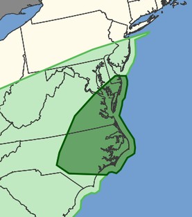
I know the event has yet to unfold, but recall a few days go, someone asked "is this it for svr for awhile for the region? And look at the DY3 outlook from 8/18 (attached). Now? 5% tor risk hatched? So it shows how things that do not look so good 3+ days out, can turn around, and sometimes big. The fine mesoscale details are everything, and sometimes it is only apparent that day hours before, or sometimes in real-time (June 5, 2024 comes to mind). May 3, 1999 epic OK tor outbreak. It was clear as mud as to the extent of that event. Morning outlook had SLGHT, upgraded to MDT by 1630z, and the 20z outlook when HIGH. The issue that day was lots of clouds and enough diurnal heating for storm to fire in the first place. And it was not synoptically-evident big tor outbreak day. And yet the result was the biggest single day OK tor outbreak for total tors (66) on record, and some monsters that revealed some amazing data from the DOWs. June 29.,2012 derecho here. That morning it was SLGHT, and by the aftn update, it was upgrade to HIGH as it was apparent the derecho in the OH Valley was taking on a life of its own, and again a historic event. The above are the exceptions, not the rule, but it shows how we can still be "surprised." And that uncertainty still exists today, despite all our advances.
- 2,604 replies
-
- 1
-
-
- severe
- thunderstorms
- (and 7 more)
-
It seems just E of I95 and just S and SE of the metro is always "in play!" The way I approach it now is, "is the area between a line from DCA and IAD and about 15 mi to the N in play b/c this area seems most variable and gets the shaft, relatively speaking, more often that not. Probably due to the location from things like downslope from the Appalachians, but it seems very dependent on the mean flow. W and WNW seems to be not good often (DC split), but of course, this is just a broad view. Subtle differences in the mesoscale can be huge.
- 2,604 replies
-
- 1
-
-
- severe
- thunderstorms
- (and 7 more)
-
Deep layer shear is good tomorrow, and there an solid 250 mb jet involved, unlike last time, so better dynamically. HRRR really makes the CAPE stand out over the entire bay. PWATs come up nicely during the day, so do sfc dew points.
-
Augdewst 2026: Summer's Last Stand
vortex95 replied to Prismshine Productions's topic in New England
@CoastalWxdoes not realize the RPLUS for ern sections is not fcst for tomorrow. The srn MCS is long gone. The big GHG rains are overnight Fri. This is not purely a diurnal convective event! -
Augdewst 2026: Summer's Last Stand
vortex95 replied to Prismshine Productions's topic in New England
Past performance is no guarantee of what happens "next time!" -
Augdewst 2026: Summer's Last Stand
vortex95 replied to Prismshine Productions's topic in New England
@CoastalWx mode -- downplay by default. I know this attitude b/c if one does not get excited at all and dismisses, then less disappointment. But if it does occur, that makes for good. It would nice if you could provide more than EEYORE-natured one-liners. I guess that's what nearly 178k posts do, makes one jaded and worn out! -
Augdewst 2026: Summer's Last Stand
vortex95 replied to Prismshine Productions's topic in New England
Both RRFSs show a 4" max near GHG. That's not nothing special! -
Augdewst 2026: Summer's Last Stand
vortex95 replied to Prismshine Productions's topic in New England
What about the RRFS (both versions?). -
From past events, they should keep the same name. HU John in Sep 1994 (longest-lived lived TC on record) did this twice! Once crossing the Dateline going W and then back over it moving NE! It caused some system issues w/ the NWS and JTWC, as the computers at the time refused to accept a TC crossing from W of the Dateline to E of it b/c it has not happened before, at least in terms of how their systems were designed back then.
-
Augdewst 2026: Summer's Last Stand
vortex95 replied to Prismshine Productions's topic in New England
Where has you been? Long-known GFS gets TC spin-up happy after a week. Has been that way for over 10 years. If I had a dime for every time the GFS LR hit New England w/ a hurricane in the last 20 years? -
Augdewst 2026: Summer's Last Stand
vortex95 replied to Prismshine Productions's topic in New England
The 18z HRRR up'ed the ante big time. The two versions of the RRFS are have the same idea w/ one max swrn CT (what else is new) and another near former stomping ground of @CoastalWx (GHG). NAM/HRRR/RRFS show a weak sfc/925 low developing near the S coast and takes its time moving E, so we get comma head backlash in ern MA. There is a stronger upstream 500 trof moving into the Great Lakes by early Sat, and that would tend to move things along. However, the system impacting SNE has little in the way of reflection at 500. It's all low-level, so standard trof "kicker" rules may not apply here. Weymouth 6" special like last year???? -
Augdewst 2026: Summer's Last Stand
vortex95 replied to Prismshine Productions's topic in New England
Bob likely had several spinners in SE MA and CC, but this was two years before the 88D was installed and prior to the NWS MAR (Modernization and Restructuring) in the mid 90s. Documentation of spinners in the NEUS prior to this time? I was not impressed. It was not nearly as systematic and detailed as it is now. Also, the sheer scale of the HU wind damage likely precluded any tor investigations for Bob. Look at this statement from the PVD WSO a few days after Gloria (attached). First, @weatherwiz proby be like, "This is blasphemy! They did not officially counts these! EVERY spinner in New England is a BIG DEAL!" Second, this proves my point about the practices in these days. They had valid and reliable tor reports, but chose to "punt" and do this instead. These tors here do not show up in NCEI Storm Data, so they are not part of the official record. 5 tor reports here, that is significant. How many single days have 5 tors in New England, let any tor in RI? Going back to 1950, up until Gloria, there were only 2 official tors I think in RI in Storm Data, and there were 3 reports from Gloria alone. That is huge from a climo standpoint! Side note: The following year, RI was "vindicated." You had this highly visible spout in Narraganset Bay just offshore of Bristol on July 3, 1986 (not the 8th as said here), and clearly seen from the PVD airport. https://www.pinterest.com/pin/july-8-1986-bristol-rhode-island-narragansett-bay--63894888436120341/ And then RI 3 spinners Aug 7-8, 1986, including an F2 in downtown PVD!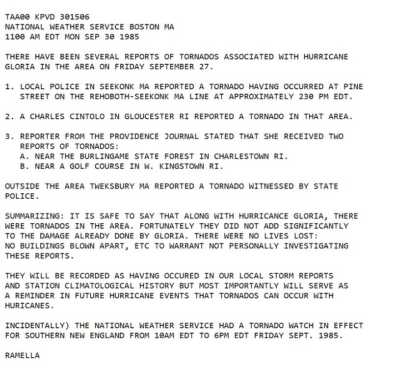
-
Augdewst 2026: Summer's Last Stand
vortex95 replied to Prismshine Productions's topic in New England
Yes, but this common, esp. in shallow marshes/swamps in S FL. Too many hype-masters act like it significant, but it is not. Also, we have many more marine sites now, not just from NDBC, but NOS and private organizations. You have an entire dense network dedicated to the coastal Everglades (see map attached), so finding a location that has 100 F water temp is not hard these days. What happens if the area is in a dry period or a single location just happens to miss out on diurnal SHRA/TSRA for an extended period in the summer, that stagnant shallow water heats up, but as soon as you get heavy rain at the location, you'll see the water temp plunge into the mid 80s. All this is normal. I see posts merely for hype and content, showing coastal water temps in the low 90s for the cntrl and srn part of FL, when again, this is normal every summer. The angle used is that "this is big fuel for hurricanes!" No, it is not. Local shallow water this warm is not a factor, and really, well before the core of a TC gets to these locations, it has already rained and the water temps have dropped significantly! You need large areas of warm water, and not just skin deep, for a TC to thrive and get intense. And this I bet many are not aware, even some mets. The limit for SSTs over large, open areas (key here *is* "large" and "open") around the globe is ~30-31 C. This is b/c at this temp, evaporation matches the incoming solar radiation, so that caps things off. Also a factor, many areas where the SSTs are this high, the atmosphere is conditionally unstable, so large areas of SHRA/TSRA are common, never mind semi-permanent features such as the ITCZ and monsoon trof present, and this also keeps things in check for SSTs.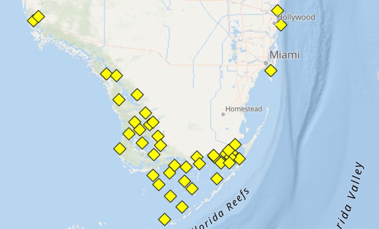
-
Augdewst 2026: Summer's Last Stand
vortex95 replied to Prismshine Productions's topic in New England
What does BN mean? Barnes & Noble? -
Augdewst 2026: Summer's Last Stand
vortex95 replied to Prismshine Productions's topic in New England
Synoptically there is light NW flow at 925 mb over FL still tdy, so that makes such events more likely, but as we saw ydy, the mesoscale details were everything. It all lined up perfectly for 2-3 hr. Law of averages and large numbers say this will happen at times! And this time, it just happened to be at a long-term climate site. Also, when one extreme occurs, another one like it in the short-term is often much more likely. Similar patterns breed similar sensible wx. How about that period Jan-Feb 2015? Probably one of the most spectacular examples for New England, and it was so localized, confined to ern MA/RI and Downeast ME, but it was @CoastalWx "VIOLENTLY RELENTLESS! " It used to be thought heat bursts were rare, but once the NWS and FAA installed ASOS/AWOS in the 90s w/ so many more locations and 1-min obs 24/7, we found they are a lot more common than we thought. -
Augdewst 2026: Summer's Last Stand
vortex95 replied to Prismshine Productions's topic in New England
Thanks. As w/ so much, there is usually more to the story, or details to add that change what one (or the MSM) may think immediately. You can't just gloss over every event. Not all record high temps, for instance, are due to a large-scale pattern that promote high heat or anomalies. An example would be a heat burst, which are mesoscale phenomena, and I think all-time records at some locations across the globe are due to this phenomena. Another example, and in colder climates this is often the reason for record temps, are local, strong downslope winds (chinook, foehn, sirocco, etc, -- there are many names across the globe for this!). Here's another recent case for hot temps. Hong Kong recently recorded its all-time record high temp (98) on Aug 9. Why?, b/c downslope offshore winds from Typhoon Dolphin that made landfall well to the N. So given the strong tropical sun and lower dew points, why wouldn't this happen? But it does not mean there was a big heat wave in progress across southern China or "heat dome" present! Dolphin was a very large typhoon at landfall, so the atypical part here was that many typhoons make landfall in ern China, and the vast majority of the time, you don't get record hot temps to the S. In this case, you had very long parcel trajectories originating deep within the Asian continent, so there you go. Daily or monthly record high temps have occurred in the CONUS b/c of this. Corpus Christi has had this happen a few time when a hurricane made landfall to the NE, as one example. Where did the dry air pocket come from in FL ydy? I don't know, but it was small-scale, so it does not represent the synoptic or hemisphere pattern either way! And aren't such wx details cool? It shows the sheer variety of what can happen and how there is always something new to learn or something one was not aware of. -
Augdewst 2026: Summer's Last Stand
vortex95 replied to Prismshine Productions's topic in New England

-
Augdewst 2026: Summer's Last Stand
vortex95 replied to Prismshine Productions's topic in New England
@kdxken Not trying to be dogmatic or do any post slamming, so don't take my responses personally. Just stating facts and providing some background/clarification on wx stats and perspective, as wx stats/history is a passion for me. and will apply a bit of levity when I can! -
Augdewst 2026: Summer's Last Stand
vortex95 replied to Prismshine Productions's topic in New England
TPA last year?, it seems that where the ASOS in relation to the runway, and the location of jets that taxi on the runway at the time from flight plots (turn point/wait point is in direct line of ASOS), that could have nudged it to 100. In the large picture, this obsession w/ 100 F. 100 is base 10, first number to go from 2 to 3 digits, and psychologically satisfying number, so somehow that makes it more significant from a wx/climate POV? It's a U.S., and more specifically, E Coast-centric mindset, as 100 is not that common. Well, there is a world outside of the East Coast! And we just happen to use the F scale. In C, benchmark numbers for hot temps are 30 and 40 C, so 100 is not some magical number here from a wx/climate POV universally. And we have the K temp scale as well --- oh wait, I just realized how we can hype the heat more! Use the K scale instead, it is *so* much hotter sounding (100 F = 311 K)!!!!