vortex95
-
Posts
1,493 -
Joined
Content Type
Profiles
Blogs
Forums
American Weather
Media Demo
Store
Gallery
Everything posted by vortex95
-
Be wary of 2m temps more than 5 days out. They do not incorporate MOS climo into their values. I've seen the GFS 2m a number of times fcst 110 F at BOS a week out, and the all-time high in New England is 107 F. That being said, does the ECMWF and other global models have MOS like the GFS? If so, where can the output be found?
-
Yes, I vividly recall one event in July 1980. N to S cell movement w/ svr, and it was a nasty mid evening event. That's what stuck in my memory as to, "look for for storms that move N to S in hot ridge patterns!" Summer of 1980 was among the biggest heatwaves and drought on record for the CONUS.
-
At this range, I am just looking at the wavelengths and axis of the ridge. That has not changed much in the last several days overall. The point being it appears New England will be on the fence for big heat. Tastes of heat but lots of caveats present w/ cloudiness, extent of convection, and weak fronts hanging up over or just S of the region. It's not a classic Bermuda High situation w/ solid low-level SW flow for the best heat in the NEUS. But in some ways, I think this will be better if one like tstms. We don't get ring of fire solid situations every year here. Just HHH for days on end, that's get kind of boring after a awhile for some. Very warm/humid w/ bouts of tstms I think many would enjoy better.
-
T for BOS for pcpn June 1999, but not long after midnight on 7/1, crushed w/ TRW+!
-
Tomorrow svr risk looks so-so. Once again, we see to be lacking in CAPE. MUCAPE struggles to reach 2000 anywhere. What time of year is this? Wind fields are ok w/ largely straight hodographs on the RRFS, but the NAM shows some messy loops at the lower levels. It's a fairly solid 500 s/w for late June and a 250 mb jet max as high as 145 kt moves right over the region tomorrow aftn, which is outstanding for a svr day here in the summer. 65 kt at 500 over SNE. HRRR looks more impressive that RRFS for "meaty" storms and coverage. Maybe an upgrade to SLGHT for some of region 06 or 13z Fri.
-
The GFS and ECMWF both show the heat tempered in the NEUS. Ridge axis is too far W and the ridge will be "dirty" w/ lots of mid and high clouds spilling over it into the region. Also, frequent minor s/w in the NW flow will likely promote significant RW/TRW waves w/ weak FROPAs and sea breezes. GFSX MOS does not show BOS above 83 through Thu of next week. Western New England should have some 90s tho. So the big heat PT needs to be put on hold for now IMHO, but the tstm prospects look quite good and WxWiz should get plenty of his EMLs feeding into the region! Storms dropping from the due N can be really nasty in such a pattern. It does not happen often, but when they do, look out. Overnight wild LTG shows are common (thank WxWiz's EML!).
-
AI just add another layer. Now it is easier than ever to create flashy content, and this floods the market even more. FB and LinkedIn are *loaded* w/ this this crap now, and it is spreading.
-
Different time and can't compare to today. The problem is everyone doing it now, and thinks they can get rich or a make living. Pipe dreams as the piece of the pie is sliced so thin, there is little left for any individual. It just becomes race to the bottom w/ more ridiculous claims and hype, and ppl do not know what to believe, and thus start tuning it all out. How is that good for society as whole? One can't deny the detrimental impacts here. That's what I am pointing out. I know how it is and how it will not change.
-
Not contesting that. It still does not change that it is detrimental to the public b/c of misinformation or gross exaggeration, or the ethical and moral issues.
-
Something to keep in mind w/ the fcst upcoming heat and big ridge in the CONUS, and a good FYI b/c I have found the MSM and others had no concept of perspective and context, let alone wx history. 600 dm 500 mb height is often used a benchmark for record heat. But it is *far* more common than one would think, just by RAOBs alone. Attached is a .txt list I got some years ago of all 600+ dm height for NAMR RAOBs. It has occurred 199 times from 1957-2006 - hardly a rare occurrence overall. In recent decades, we tend to see 600 dm height on model analyses and forecasts more b/c the resolution of the models has increased significantly, so that's not really an apples to apples comparison as to change in frequency over time. RAOBs are in situ, directly measured, not model output. Of note in the list: 604.5 dm Adak AK (ADK) July 1980 That high that far N?...wow. But it makes sense, there was an intense heat wave/drought in the CONUS that summer, so upstream was also quite anomalous! What kind of sigma deviation value would show up here I wonder? You know, those 500 mb height values used by climate alarmists -- e.g. "a one in a 75 million year occurrence!" Which is obviously bunk. The wx in the real world doesn’t follow a Gaussian/normal distribution curve. Extreme events are far more common in a non-Gaussian distribution that reflects the physical world we live in. This is a case of lying or conflating an issue using statistics. 602.6 dm Wallops Island VA (WAL) July 1986 Make sense, SEUS very hot that month. 609.0 dm Chatham MA (CHH) Sep 1989 This was the very strong ridge that flung Hurricane Hugo into SC, and the highest on record for Mid-Atlantic or NEUS in the period. I do recall this ridge, and seeing Sable Island, Nova Scotia RAOB 600 dm. Somehow I missed the CHH value! And it was *not* record heat anywhere on the E Coast. Very tropical and warm for mid-Sep, but not that hot. 612.2 dm Peachtree City GA (FFC) Sep 1994 For a lower elevation location, relatively speaking, that is amazing. Most 600+ dm values are found in high elevation sites. 11 instances of 610.0 dm or higher in the data, enough to suggest that this is attainable w/o equipment error. 601.0 dm Whitehorse YK (YXY) Feb and Oct 1996 Again, that high that far N?, and one in Feb no less! Goes to show it is not always a warm season phenomena, let alone associated w/ record warm temps (why heat done is misleading). In early Feb 1996 there was record Arctic outbreak in the CONUS w/ Tower MN dropping to -60 F. namr600hgt1.txt
-
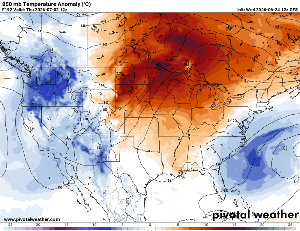
Regarding the Instagram post and its content: Whatever happen to just "heat wave?" Ever notice that is not used anymore? Marketing. Change the lingo to sell it better, nothing more. Also, attached the GFS 850 temp anomalies today and valid 7/2. Just focus on the heat, and ignore cool wx for this time of year, as if all that matters is population where it is hot? That's cherry-picking and blatant bias, never mind fear-mongering and only focusing on what is "bad." Deplorable behavior for someone who has lots of followers and influence. And what, the fact is gets very hot in the summer is somehow unusual? It would be unusual for it *not* to get very hot at rimes, and some summers are hot all the way through, like 1980 and 1988. Don't get me wrong, I like HHH wx a lot, but can it just BE? Meaning can it occur w/ a million bells and whistles or finding meaning/prophecy of doom?

-
A less hot pattern would mean more tstms in NW flow w/ your REQUIRED EML! LOL. Be careful what you hope for!
-
I'm not too keen on persistent heat in the NEUS. 00Z ECMWF says no go. The ridge axis is well to the W so that makes NEUS susceptible to BDFs/onshore flow/more clouds/pcpn. GFS says yes to big heat tho but even that suggests it won't last. Mean trough position near/along the E Coast has been tough to shake overall.
-
Reed Timmer movie Aug 23. https://www.youtube.com/watch?v=eEiy7y1ETF8 I don't deny that he doesn't get great video, but the caviler and reckless attitude I have issues. Many get the idea that storm chasing is easy and anyone can do it, which is not true, at least from a safety and responsible POV. This is a skewed presentation of how it really is. The trailer is about as cliche and formulaic as you can get. And what does jogging in slow motion have to do w/ storm chasing? Talk about an intro that has been done 1000x over. That's the best they could do for an intro? And as if storm chasing has not been dramatized and romanticized enough already? I fear the roads next spring. We keep thinking, "how can it get worse?" and then witness another year. And if this movie does very well? You can expect a flood of more wx movies, some downright egregious, as everyone tries to cash in on the renewed fad/novelty. Recall what we saw after "Twister" in 1996? We got "Night of the Twisters" and "Tornado," and it seemed every popular show on TV at the time had to insert a tornado into the plot!
-
Yes, it is based on the June 3, 1980 Grand Island NE event (look it up, PT material for sure). It was awesome? How did you like the anticyclonic hurricane over Nebraska as what the storm looked like? And the "chase" scene or the climax is the apex of cheesy silly (tornado "following" the family in their car). At least "Twister" tried. It has some issues, but I can forgive for artistic license to a point, as it is for entertainment. For a wx movie, it was about as good as you make one IMHO w/o going off the rails silly/stupid!
-
WxWiz will buy his tickets 1201am the day they go on sale and make sure he is first in line at his locate AMC! Opens Aug 21. https://www.youtube.com/watch?v=eEiy7y1ETF8 The trailer is about as cliche and formulaic as you can get. And what does jogging in slow motion have to do w/ storm chasing? Talk about an intro that has been done 1000x over. That's the best they could do for an intro? And as if storm chasing has not been dramatized and romanticized enough already? I fear the roads next spring. We keep thinking, "how can it get worse?" and then witness another year. And if this movie does very well? You can expect a flood of more wx movies, some downright egregious, as everyone tries to cash in on the renewed fad/novelty. Recall what we saw after "Twister" in 1996? We got "Night of the Twisters" and "Tornado," and it seemed every popular show on TV at the time had to insert a tornado into the plot!
-
-
And never Ossipee? The Weymouth of the North!
-
I'm glad you brought up temp anomalies. This may have been mentioned prior, but I think the temp sensor at BOS is running at least 1 F too warm. Through 6/22, Logan is running 5.4 F above avg for the month. No other long-term climate location in New England is higher than 3.9 above for the month. Examples: PVD 3.9, ORH 3.8, CON 3.4,and BDL 2.1 above avg for the month so far. And I did a check of May. BOS +2.4, but PVD +1.1, ORH -0.3, CON -0.4, and BDL -0.6. This discrepancy may go back further. This goes to show that even 1 F off for temp is a big deal when over an extended period, and that significance increases as you get further out. 1 F avg higher for a year is more significant than 1 F higher than avg for a month, as one example. See how wx sensor issues, never mind UHI, can skew temp records and easily give an unrealistic picture of trends if not addressed in a timely fashion? Temp sensor calibration and other issues are nothing new, EWR had a +2 F bias for a few years this decade. I think it is corrected now, but it was *so* obvious there was an issue. Every month, EWR was 2 F warmer than NYC, LGA, and JFK, and the distance from EWR to all 3 of these locations is 20 mi or less, so no way EWR did not have a warm bias. Sometimes a warm bias at location is due to new construction nearby or the temp sensor re-located, and in both cases artificial heat sources contaminate the temp readings. What's worse, most of the time, these obvious errors go into the official climate record uncorrected. See the issue here? When wx stats are reported to us, we assume that they are accurate. Not always, and systemic errors do add up over time and can make a big difference. But rarely do you see any outlet, big or small, mention the margin of error/uncertainty in measurements or note there is a problem at a site. And one important item that complicates the issue. ASOS/AWOS are designed primarily for *aviation* use. This means VIS, cloud cover/height, wind, and altimeter take precedence, and T/Td are secondary. And most climate sites in the U.S. and globally are located at airports, which is not ideal due to UHI and proximity to large swaths of asphalt and jet exhaust. So being skeptical of the temp records and trends are certainly justified, and the bias is warmer, not cooler, so the large-scale warming that has occurred is not as high as it is said.
-
When was this? The big tor day that CoastalWx was all excited about recently? LOL.
-
I note you are being facetious here, which is ok. Social media I would argue is what influences the population most now, way more than traditional media like TV.
-
Looks like Heatmiser!
-
"VIOLENTLY BEAUTIFUL"
-
Since GFSX MOS only goes out 8 days, I assume you are looking at 2 m temps? I would not use 2 m temps beyond 5 days as they get whacked often b/c the do not incorporate climo stats like MOS does. Same goes for ECMWF. I've seen the GFS 2 m temps a number of times over the years show 110 for BOS DY7 are beyond.
-
From a former co-worker: "I'm up the First CT Lake and it's overflowing. River is 10x the normal summer flow and completely unfishable. Locals saying they've never seen the lake this high."