vortex95
-
Posts
1,493 -
Joined
Content Type
Profiles
Blogs
Forums
American Weather
Media Demo
Store
Gallery
Everything posted by vortex95
-
Snow New England below 5000 ft is practically unheard of late June into July. MWN biggest snowfall in the summer is 4" on 6/30-7/1 1988. I recall PL on MWN in July 1996. I am talking about meteorological significance/anomaly, not what moves the public needle. These are 2 different things. Location on the globe is irrelevant in the large pix. The MSM often conflates/confuses meteorological significance w/ societal impact. These two are not always directly correlated. Case in point, the CoastalWx 8 hr commute "at least I got to listen to the draft" Dec 13, 2007 event. MEH 4-8" snowfall, but the timing was the worst, and in their grand infinite wisdom, officials decided to let everyone out at noon as the S+ was in full swing. Among the worst SNE gridlocks ever, but a MEH meteorological event.
-
Not this late this low in elevation for sig amounts. It's rare. Don't conflate flakes in the air w/ 20"+! LOL. We are talking almost July here, and sig CONUS snowfall even at higher elevations is pushing it. Early June it can do it, and by mid August it can as well (see GTF in Aug 1992), but that window last week of June to early Aug, it is very difficult.
-
It seems overdone. The entire area is in severe level drought, so that significantly mitigates flooding b/c rivers are streams are low. Yes, any heavy rain in a short time can cause localized flooding, but that par for the course in a metro area b/c of the concrete jungle. IMHO, they bar appears to be lowering w/ time as to what is considered "flooding." B/c a few underpasses flood, does that verify as a flash flood? Some underpasses *always* flood even w/ modest heavy rainfall from a tstm. That's more of a drainage or local infrastructure issue than a meteorological one! See what I am getting at here? It is not hard to verify such a watch if the bar is being lowered or you consider any significant ponding of water a flood. The flood watch was likely issued b/c it is DC, which it is obvious there is a bias for more watches/warnings here, but also due to the 250th events. I get that from a social/political/economic POV, but objectively, it is not following overall meteorological risk or science well. Noting stands out for this evening for significant flash flooding, HRRR/RRFS show a few local spots 1-2" this evening, but they are largely E of metro. Watches are typically issued based on a minimum coverage of the hazard expected. This does not meet such criteria for flooding IMHO, esp given the antecedent very dry conditions, which is a big deal when it comes to flooding risk and extent. Case in point, when Floyd ran up the E Coast in Sep 1999, excessive rains in VT of 4-8" caused only moderate flooding. When Irene did the same in Aug 2011, that same 4-8" resulted in near recorded flooding. Why? B/c the summer of 2011 was one of the wettest on record here, and the summer of 1999 was among the driest.
-
Unclear yet the exact timing of when the ridge breaks down/retrogrades to the W somewhat, but it should happen by early next week at the latest IMHO. Models have shown this for several days now. These NW ring of fire pattern can be quite good. If we can get a solid EML here, that means big potential for overnight convection. One thing I have noticed, overnight convection when an EML is present, the LTG is often wild, not unlike what occurs in the Plains/Midwest b/c the EML is a semi-permanent feature spring-fall here.
-
Do you mean 1995? That's when BOS hit 100 for the first time since July 21, 1977 (102 that day). It took that long for the UHI to catch up so they could reach 100 again. The temp sensor was moved from tucked back near the WSFO at Logan to the middle of the runways surrounded by water on 3 sides in the late 70s. July 14, 1995 was the 100 in BOS. July 15 is when CT tied their all-time record high of 106. In between this early on the 15th, the WxWiz and CoastalWx "fantasy" derecho occurred in NY and western New England. Easily the worst derecho in the last 50 years for the NEUS. https://www.weather.gov/aly/derecho1995
-
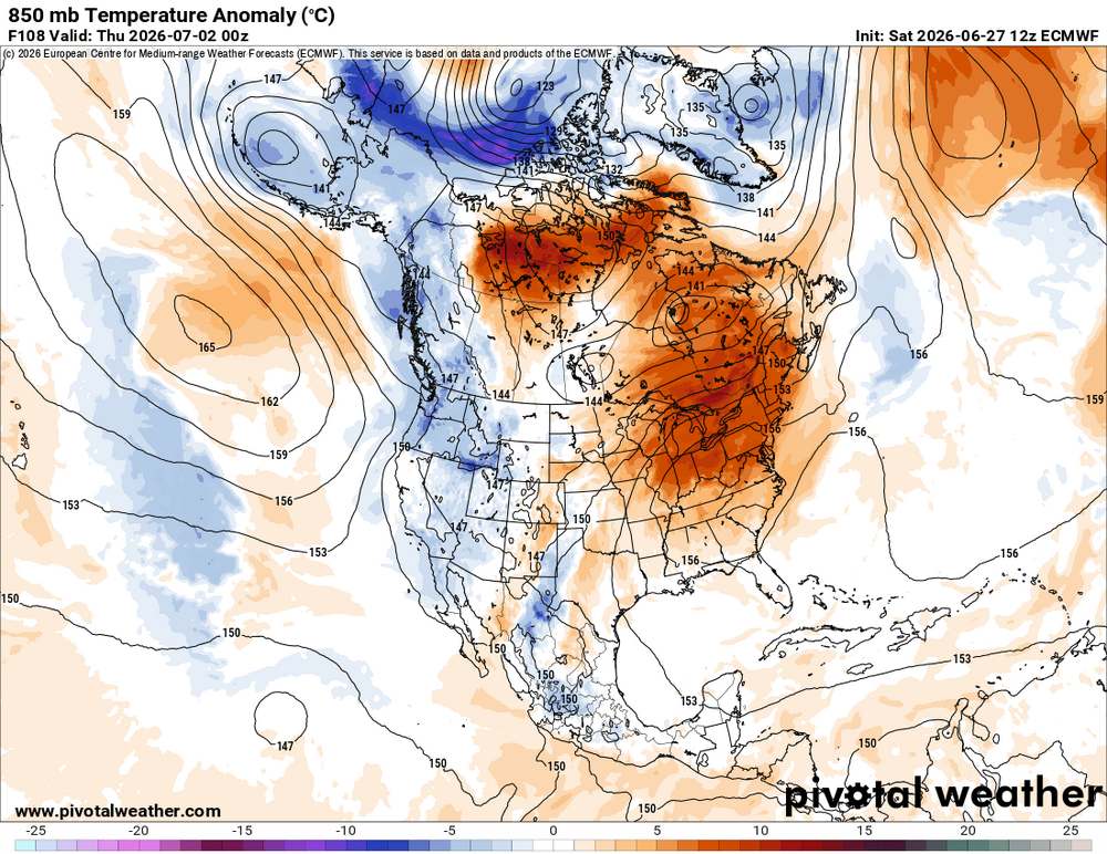
For the talk and hype about the upcoming heat, it is really will be confined to the Midwest to New England and TN Valley to the Mid-Atlantic. Pretty tame for temps the other 70% of the CONUS this coming week. See 850 temp anomalies for the ECMWF valid 00z 7/2. Point being this is not summer of 1980, 1988, or 2012 wild levels (so far). Not downplaying the heat at all, just keeping things in perspective in the large scale. There is world outside DCA-BOS!
-
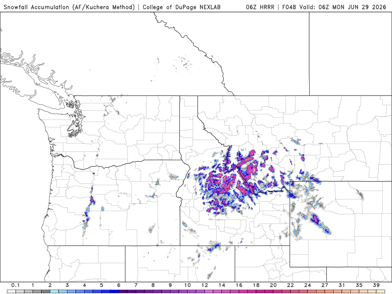
Meanwhile, out West the next 48 hr. -4.7 sigma 500 hgt anomaly w/ this trough. This is impressive S+ even for the Northern Rockies for so late.
-
Got it. Yes, it looks delayed b/c the ridge builds stronger overall on the E Coast this coming week than earlier models showed.
-
Road trip for Scott? Of course the MSM will ignore this atypically late season S+ even for the Northern Rockies (up to -4.7 sigma hgt anomaly at 500) and just talk about what has not even happened yet w/ its obvious E Coast bias, rather than talk about what is occurring in the here and now.

-
Just talking about through the end of this week. It looks interesting by next weekend here on the GFS. ECMWF suggests it would after next weekend. The hot ridge breaks down somewhat on the E coast so stronger NW flow w/ embedded troughs.
-
I think the tstm/derecho threat will be confined the Northeast. 700 mb temps are too warm for deep convection here. +10 usually caps it off this part of the country, and they get as high as +13 this week and stay AOA +10 thru Fri. 1000-500 thk stays AOA 579 much this coming week, peaking at 583, which is typically too warm a column for tstms unless you have good forcing.
-
Lest we forget! Washington DC ended a streak of 2867 days w/o 100 F reading on 6/22/2024. This is the 5th longest period on record since 1872. So "we're due" for a big heat wave??!! | Does this mean DMH will be 110? LOL. Actually, did they fix the issue b/c I look at the temps this month BWI vs. DMH, and high temps are close. June 11-12 -- both days 97 at BWI, and 98 at DMH. Still DMH seems to avg 1-2 F warmer for highs overall, but that's a *far* cry from the 5-7 F difference last year and before. BWI would be 97 and DMH would be 104, and that went into the official climate record! It appears now DMH just has the typical city UHI bias. Seems like when they did that construction a few years ago at the Science Center and DMH was offline for a while, it made the heat contamination worse. More concrete walkway all around and a solar farm within stone's throw. Just incompetent planning. It's like all these wind farms, and ground clutter contamination that occurs even far from WSR-88Ds. Take a look at DDC, VNX, and FDR, as examples. It's really bad. Eventually, there is going to come a time when a TOR is missed due to this wind farm clutter and lives lost I'm afraid.
-
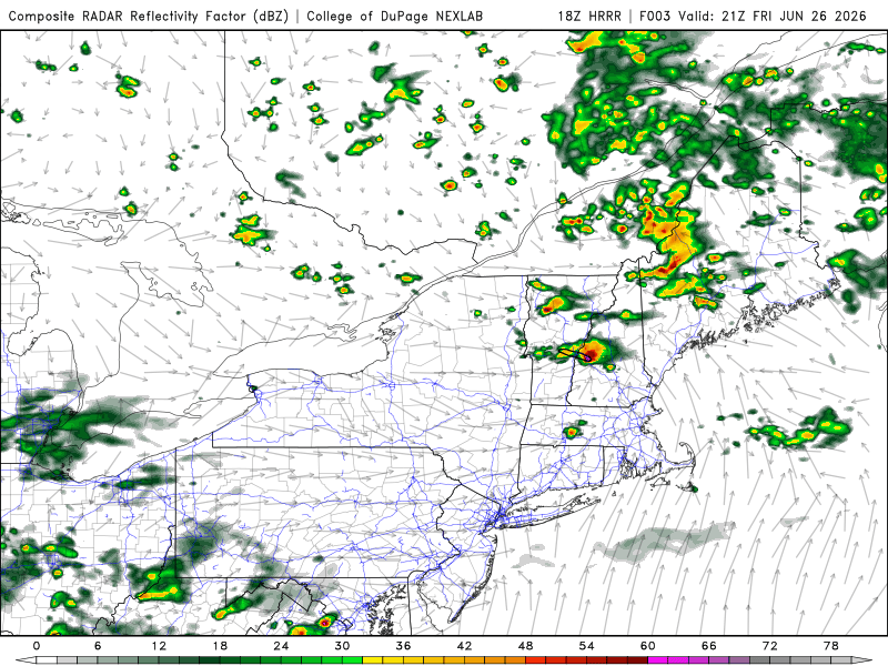
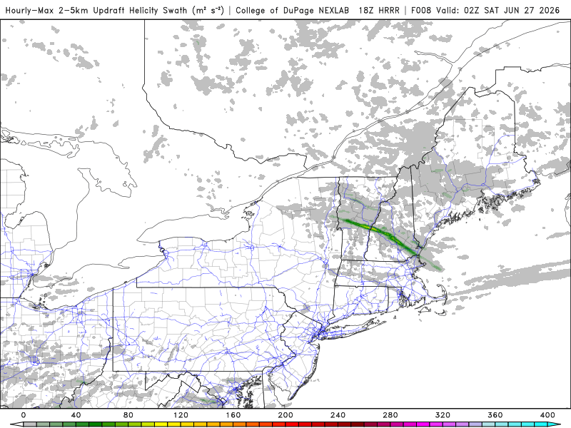
You know it's bad when you try to just click a reaction emoji for a post, and it fails! CoastalWx is just relieved it's not winter currently. He just says "MEH!" to the 3 supercells today in SE NH and NE MA!
-
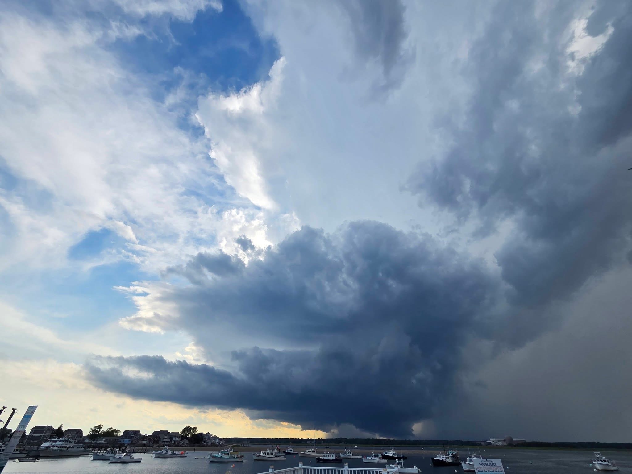
Seabrook NH a short time ago. Photo by Rich Hamel. That's about as good supercell structure you will see in the NEUS.

-
Seems like the "bad gateway" error is the worst it had been thus far. Not much CGs w/ the supercells. Once again, lack of solid CAPE. Best CAPE is "only" 1500, but the excellent shear is compensating.
-
HRRR showing a "Hampton Beach Special." Right mover!
-
"High-handed" is a subjective term and instead of going on the defensive perhaps you should consider a more reasonable/productive approach. I stated clearly previously the value of the debate/discussion. High-handed means using excessive authority. How did you arrive at that? What "authority" are you talking about? Stating facts and opinion/views are not inherently authoritative. I have kept this discussion civil and reasonable, and it gets labeled as "high-handed?" "no one is going to really care accept you about hype ( that no one really takes seriously anyway? ) which is endemic to the environment you both choose to be a part, and are not going to change." Now you are attacking what I had said on other posts and wx hype and how that influences us all and skewed perception, as if acting like is trivial or no one should care. Just b/c something is endemic does not make it right or should not be called out in order to 1) make ppl who are willing to listen aware (once again, not everyone is on the same level on this forum as to knowledge/experience) and 2) strive to do better/improve ourselves. The social part of wx is by *far* the biggest challenge we face now on many fronts. It's main reason why the NWS has been engaged in IDSS for over 10 years now. And these social issues exist to the from the very top powers that be to the individual on social media. It is integral part of wx now, like it or not. So I am going to bring it up as it relates to the hard meteorology.
-
I assume you are being facetious. As I said, debate/discussion is what the forum is all about on a fundamental level.
-
One should avoid typing any word in all caps in a civil discussion/debate on social media. It is unprofessional and just promotes conflict. "Not to me anyway?" No one is above criticism, no one. Debate/discussion is how science advances. You really think one can post on a forum like this and not get criticism at times? And criticism is often thought as always negative. It is not, not when it done reasonably and w/ civility. Silencing debate/discussion or making oneself immune/above itall is not a good thing. What you seem to be overlooking is that very fact that is criticism and debate are a good thing overall b/c many read the posts, and can learn something from what is said. Not epiphanies or anything like that, but wx tidbits/info they can take in and absorb, and also can see a productive way to debate/discuss and the way *not* to do it. Not everyone here is an expert meteorologist. Some are up and coming mets and still learning, some are wx enthusiasts, and everything in-between. One needs to consider all members of the forum here.
-
That's so "FETCH!" What decade are you living in?
-
I never contested no decent heat, just I think and we see this a lot, the hype alone about a hot period coming up or any inclement wx, all too often takes on a life of it own, and many, included some on this forum, get caught up in the social media hype and mode, and that skews their objectively, as in "I called it first!" or one makes it into more of a deal than it really is. And you'd think it like it never can get hot here, or anywhere else for that matter, and it's end of days. What planet are these ppl living on? It would be highly atypical not to have bouts of well above avg temps anywhere on the globe over time. And I don't want to here about the climate change factor. Forget that factor for a min, and just look at wx history and what has happen before, and how fundamentally the Earth works for heat balance/distribution. That is what is being demonized and hype, the normal order of things - "OMG, impactful/stormy wx is occurring -- PANIC!" The above all rolls back into our perception of things, how we treat/handle it all, and zeitgeist. Things like this need to be said at times b/c ppl often forget, caught up on the social media frenzy. How we view/handle/discuss issues/things in general are just as important as the issues/things themselves.
-
I was stating solid forecast concerns, that's all. And personally? No, debate/discussion is what this forum is all about. The content of your response by itself suggest you take it personally. How one goes from someone stating forecast concerns and caveats to "don't like the heat" is a non-sequitur argument. Mentioning fine details is not the same as nit-picking, and the details count in any science. You were mentioning how its looks good for sig heat at least from a 500 mb height position, but did not mention that 500 mb is not always a good proxy for sfc temps. "that 00z operational Euro run fully committed to a heat wave later next week .. LOL At least at 500 mb..." So I pointed out the omission. This is of value for others on the board, is it not? It is fact CPC and others often just look at 500 height anomalies, and run w/ temps based on that alone. And "tough cookies?" What kind of statement is that in a serious meteorological discussion? Don't degrade a discussion/debate w/ drivel phrases/terminology like that.
-
The main issue here is that to may look all fine and dandy from a 500 hgt, 1000-500 thk, and 850 temp POV for heat, but clouds/convection/weak fronts/onshore flow can negate these obvious factors at low-levels quite well. The caveats are rife here for next week and the local/mesoscale will likely modulate temps big time, esp. in eastern New England. Yes, synoptically it looks impressive, but one can't say this enough for certain set ups. and this is one of them -- the details are everything!
-
We don't live at 500 mb, and using 500 heights alone says nothing about what the sfc temps may be. Convection/fronts as factors are significant as the ridge is dirty w/ its axis at 80W. This precludes a solid Bermuda high set up need for sustained or unabated heat. The details are everything here, so going all out for big heat is premature for New England. GFSX MOS still shows no 90 explicity forecast E of a LEB-CEF-BDL line.
-
I know this has been said before, but do *not* use 2m temps on any model more than 5 days out. They are literal model output w/ no MOS climo factored in! GFS at times has fcst 110 F at BOS over the years, right!