

vortex95
-
Posts
1,493 -
Joined
Content Type
Profiles
Blogs
Forums
American Weather
Media Demo
Store
Gallery
Everything posted by vortex95
-
Yes, PDS - particularly dangerous situation. I am just talking about how blizzard and ice storm warnings will have this label soon as an option.
-
-
GFS MOS has been trending down since yesterday for BOS. 7/1 12z Sat it had 98, now it is 82 12z run today. and gets it no higher than 92 7/2-3. PWM has been going down as well, now no 90 fcst on the MOS. Dirty ridge clouds are a problem along w/ waves of RW/TRW. Also onshore flow from weak FROPAs. You are not going to max out sfc temps what 850 temps suggest in such a pattern. It is unwise hedging so high early on given the uncertainties that have existed all along, esp. for eastern New England. It is better to start more modest far out, and then adjust, if necessary, as the event gets closer.
-
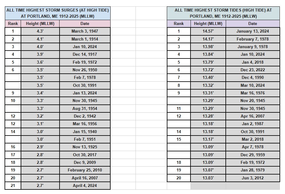
Here something a little different for general FYI. I got this table of highest storm surges and storm tides for Portland ME (PWM). I learned a few things here. Storm surge and storm tide are 2 different things, but we often use them interchangeably. Storm surge is the water height deviation from atmospheric phenomena in itself, nothing else. Storm tide takes into account everything, the atmospheric contribution, monthly astro tides, the 19 year tidal epoch, coast rise/drop, and anything else that may influence a tide height. In the NEUS/Mid-Atlantic we use storm tide the most b/c we have 2 high tides a day and our tidal ranges are high. Along the Gulf Coast, storm surge used most often b/c there is only 1 high tide a day and the tidal range is low. For PWM, 3 of the 5 highest storm surges are not even in the top 20 highest storm tides, so that shows how one is not necessarily related to the other. For proper historical scaling and an objective meteorological POV, storm surge is what one would use b/c that has only one factor. For storm tides, one may note that we've had 5 top ten tides in the last 8 years. But that is not a level playing field. PWM sea level has risen about 8" in 100 years, and more than half of that is due to local land subsidence.
-
How did I get drawn into this "kerfuffle??" A couple of things for all. 1) People can agree to disagree and still be friends/civil. 2) Debate/discussion overall is a *good* thing! That's how science advances and everyone learns more. Not just objective facts, but improve ways to present and communicate, which, IMHO, is the biggest hurdle we face, esp. in this social media age. Tone, inflection, and countenance, among other things, are lost via social media and it is all too easy to assume the negative, and then ppl get upset and the conservation devolves or shuts down. That's not good.
-
IMHO, one better have darn good reason and solid model agreement when forecasting all-time record events. esp. several days out. You don't just pick the most extreme scenario b/c that grabs the attention more to drive the hazard home. It is better to start more modest and work your way up as the fcst details become clearer. When you start at the top, it's very hard to come back down b/c of the viral nature of things on social media. And really, we know its going to very hot, so "piling on" tends be counterproductive (the apathy factor, and ppl get wise and say, "is it really that bad/dangerous b/c we've had 100+ before, and did just fine overall). This is not being snarky, the hype pushes things like one should not even go outside at all b/c it is so "dangerous" b/c it is 100 F. How did we ever survive as a society prior to this in-your-face danger hype or before AC, for that matter! The problem is the media doesn't act on a "linear scale." It's like if the temp hits 100, somehow that is *so* much worse or extreme than 99, when it is only b/c 100 is a power of 10 and a more psychologically satisfying value. That is meaningless as to sensible wx impact. Another example? A piece of crap low pressure gets named a TS, and it is like end of days to the media, when typical winter storms are *far* more impressive and powerful than a weak sheared TS.
-
Another possible reason other than overzealous inexperience or pattern recognition denial? CYA - better safe than sorry. I find this a weak excuse these days. Forecast science and skill have come a *long* way in the last few decades alone, and we have models now that can show fine-details and fcst extreme events quite well now, so confidence level should be higher. There are less "surprises" now. We should be taking advantage of this better technology and skill that should result in *less* CYA - better safe than sorry. Over-warning I would argue is as bad as under-warning. Over-warning impacts tend to be more indirect, but still cost lives and lot of $$. "Damp street warning?" LOL. Sounds like something you'd see in Cali. Don't give them any ideas!
-
Of note, some WFO CWAs have lowered the threshold of temps for issuing heat advisories and extreme heat watches/warnings. WFO BOX did this a number of years ago. Instead of 95-100 F, it was lowered to 90-95 F. I don't know about other CWAs, but it something to be aware of as our standards and practices change over time, and the trend is lowering the bar for more watches/warnings. And the media takes full advantage of this, acting like changes in wx have demanded this, when it is social/political/economic factors, among other things. We will soon have PDS blizzard and ice storm warnings, and you can bet the media will say, "FOR THE FIRST TIME EVER the NWS has issued a PDS..."
-
I will not miss the 3km NAM when it goes away later this summer. It almost always overdoes QPF, esp. when orographics are involved. Its fcst sim radar leaves a lot to be desired as well.
-
I'm not the biggest fan of snow (used to be) - CoastalWx ready to cancel me for saying that! - but, out of season events I think are DA BOMB! The flakes in the air at the end of last month in MA was a sight to see. I've actually had dreams recently about snow falling in June in ern MA.
-
I have had that happen to me before. On the phone w/ a wx client, and I said "hit enter" and they *typed* the word "enter!" Another time I said, "where are you?" referencing where on the menu, the person said "Columbus OH!" LOL. My favorite is telling them to reboot the PC, and they just reboot the *monitor*!
-
When you switch to 5G, does it work?
-
"Anger is a gift" (said softly). FREEDOM!!!!!!!!!!!!
-
Special marine warnings? Those are a dime a dozen. Special marine warnings used to be only for convective wx, now a typical cold FROPA prompts them. Or "wind burst," whatever that is. Gradient winds will already be strong and wind advisories or high wind warnings out, which cover things well, and you get special marine warnings independent of any convection. More warnings/alerts are not always better. There comes a point of diminishing returns. Apathy, for one, b/c of too many warnings. Ppl start tuning out. It's not good to be "held hostage" by the wx. And business and commerce gets more disrupted b/c officials/authorities cancel more b/c of hearing increasing amounts of alerts/warnings. This has real economic impact.
-
I don't sugar coat things for CoastalWx.
-
Flush your DNS cache and reset your IP on my PC. It can be done from the command line prompt in Windows. Google it, it is easy. After doing it, reboot.
-
Going back a bit, I was talking about PWM record high tides on a post. I got an updated table from GYX (attached). Some interesting items that I learned. Storm surge and storm tide are 2 different things, but we often use them interchangeably. Storm surge is the water height deviation from atmospheric phenomena in itself, nothing else. Storm tide takes into account everything, the atmospheric contribution, monthly astro tides, the 19 year tidal epoch, coast rise/drop, and anything else that may influence a tide height. In the NEUS, we use storm tide the most b/c we have 2 high tides a day and our tidal ranges are high. Along the Gulf Coast, storm surge used most often b/c there is only 1 high tide a day and the tidal range is low. For PWM, 3 of the 5 highest storm surges are not even in the top 20 highest storm tides, so that shows how one is not necessarily related to the other. For proper historical scaling and an objective meteorological POV, storm surge is what one would use b/c that has only one factor. For storm tides, one may note that we've had 5 top ten tides in the last 8 years. But that is not a level playing field. PWM sea level has risen about 8" in 100 years, and more than half of that is due to local land subsidence.

-
I know the site admin. They will add RRFS but have to get the NAM off first b/c processing power is currently limited for their network.
-
What's wrong w/ CoD? I haven't had any issues on the site recently.
-
Oh I know the media is what it is and the business model. It doesn't do very good service to wx science and the like though. As mets/weenies though, we should care! Anything the atmosphere dishes out impressive no matter when or where is of significance. And we can convey that to ppl not mets or not in the know that things are not always what they seem. I have found many ppl suspect this or that about wx and can't get a straight or clear answers, and they have no idea who to ask or where to starts b/c the shear amounts of info out there and endless opinions and conjecture! Ppl like to be validated when they have practical suspicions or wonder a lot, and then hear something closer to the real deal.
-
Scott's favorite jam from 1987!
-
SWE's? Only thing I can think of for a wx acronym is "snow water equivalent!" LOL.
-
Actually, is "flash flood watch" a discrete product anymore? Recall a few years ago they removed a few types of products (Blizzard Watch was one) b/c it was getting to be too many product types. "Flood watch" may be the all-encompassing standard now? Given the antecedent very dry conditions and low water levels, again, I find a flood watch here a little much.
-
Well, this makes a point in a way. What the media (or general public) *thinks* (or believes) and what actually *is* in reality are often two different things, and wx is loaded w/ misconceptions. and egregious beliefs.
-
Correct, but as I mentioned in a previous post, there is a world outside of DCA-BOS. The E Coast bias the media has when it comes to wx is obvious. Yes, more ppl live here, but that shouldn't no matter in the grand scheme of things when talking about wx itself. The atmosphere has no bias as to what area it impacts or not or when.


