Brian D
-
Posts
3,023 -
Joined
-
Last visited
Content Type
Profiles
Blogs
Forums
American Weather
Media Demo
Store
Gallery
Everything posted by Brian D
-
April 21 1910: A snowstorm hits northeastern Minnesota. Duluth picks up 6.5 inches. For Tuesday, April 21, 2026 1958 - Portions of Montana were in the midst of a spring snow burst. Snowfall amounts ranged up to 55 inches at Red Lodge, 61 inches at Nye Mine, and 72 inches at Mystic Lake. (David Ludlum) 1967 - Severe thunderstorms spawned 48 tornadoes in the Upper Midwest. Hardest hit was northern Illinois where sixteen tornadoes touched down during the afternoon and evening hours causing fifty million dollars damage. On that Friday afternoon tornadoes struck Belvidere IL, and the Chicago suburb of Oak Lawn, killing 57 persons. (David Ludlum) 1980 - The temperature at International Falls MN hit 90 degrees. (The National Weather Summary) 1987 - Unseasonably warm weather prevailed from the Gulf of Mexico to New England and the Great Lakes Region, with twenty-nine cities reporting record high temperatures for the date. Afternoon highs of 82 degrees at Caribou ME, 94 degrees at Mobile AL, 95 degrees at Monroe LA, and 93 degrees at New Orleans LA, were records for the month of April. (The National Weather Summary) 1988 - After having had just twelve rainouts in the previous twenty-six years at Dodger Stadium, a third day of heavy rain in southern California rained out a double-header at Dodger Stadium which had been scheduled due to rainouts the previous two days. (The National Weather Summary) (Storm Data) 1989 - The temperature at Las Animas, CO, soared to 100 degrees to establish a state record for April. Twenty-two cities in the central and southwestern U.S. reported record high temperatures for the date. Eight cities equaled or exceeded previous April records. (The Weather Channel) (The National Weather Summary) 1990 - Afternoon and evening thunderstorms produced golf ball size hail in Oklahoma, and also caused some flash flooding in the state. Thunderstorms over the Southern High Plains produced golf ball size hail at Roswell NM and El Paso TX. Easterly winds and temperatures near zero produced wind chill readings as cold as 50 degrees below zero for the spring festival (Piuraagiaqta) outdoor events at Barrow AK. (The National Weather Summary) (Storm Data) 2007 - The South Plains and Panhandle of West Texas were hit by an outbreak of severe thunderstorms. Between the hours of 5 and 6 pm, several thunderstorms developed across the western South Plains. Around 7 pm, a supercell produced a tornado which touched down around Fieldton (southwest of Olton) and then moved just south and east of Olton, doing damage to several structures and equipment. The thunderstorm continued to move northeast across northeast Lamb, northwest Hale, southeast Castro and southwest Swisher Counties, producing a long-lived tornado (along with hail up to the size of tennis balls). By 7:45 pm, the storm approached the town of Tulia in Swisher County. A tornado touchdown was reported in the town, causing major damage. The tornadic thunderstorm continued to move northeast across Swisher County over open country through about 8:30 pm. (NWS Lubbock, TX)
-
That commercial came to mind
-
Poor little birdie smacked my living room window. Heard a loud thump, and when I checked, there he was sitting on the deck rail trying to regain his bearings. At least he made it. Sometimes they break their neck. Not uncommon to find a dead bird laying on the deck.
-
Another chilly morning with 10's (20's along the shore). Warm up this week will feel good. Birds are all over the place this morning. Woodpeckers. flickers, robins, and juncos, and some others. Very active spring activity.
-
Saw an interesting vid about the Asian carp. It has taken over the last few decades, but an interesting development has occurred. A group started to reintroduce the Alligator Gar after they were nearly wiped out back in the 70's, and now there are areas were the carp is disappearing. The gar are starting to clean house. Gar are native to the waterways down there. Lets hope that they take care of business in the coming decades, because those carp are destructive as hell.
-
April 20 1970: Snow falls across much of Minnesota. For Monday, April 20, 2026 1901 - A spring storm produced unusually heavy snow in northeast Ohio. Warren received 35.5 inches in thirty-six hours, and 28 inches fell at Green Hill. Akron OH established April records of 15.6 inches in 24 hours, and 26.6 inches for the month. Pittsburgh PA established April records of 12.7 inches in 24 hours, and 13.5 inches for the month. (David Ludlum) (The Weather Channel) 1920 - Tornadoes in Mississippi and Alabama killed 219 persons. (David Ludlum) 1952 - The tankers Esso Suez and Esso Greensboro crashed in a thick fog off the coast of Morgan City LA. Only five of the Greensboro's crew survived after the ship bursts into flame. (David Ludlum) 1987 - Fifty-two cities in the central and eastern U.S. reported new record high temperatures for the date. The high of 92 degrees at Memphis TN was a record for April, and the high of 94 at Little Rock AR equaled their April record. (The National Weather Summary) 1988 - A storm in the western U.S. brought heavy rain to parts of California. Mount Wilson was soaked with 4.15 inches of rain in 24 hours. The heavy rain caused some flooding and mudslides in the Los Angeles area, and a chain reaction collision of vehicles along the Pomona Freeway which resulted in 26 injuries. (Storm Data) (The National Weather Summary) 1989 - Hot weather spread from the southwestern U.S. into the Great Plains Region. Twenty-three cities reported new record high temperatures for the date. The afternoon high of 104 degrees at Tucson AZ was an April record, and highs of 87 at Provo UT, 90 at Pueblo CO, and 85 at Salt Lake City UT, equaled April records. (The National Weather Summary) 1990 - A fast moving Pacific storm produced heavy snow in the central mountains and the Upper Arkansas Valley of Colorado, with a foot of snow reported at Leadville. Thunderstorms in the south central U.S. produced wind gusts to 76 mph at Tulsa OK, and heavy rain which caused flooding of Cat Claw Creek in the Abilene TX area. Lightning struck the building housing a fish farm in Scott AR killing 10,000 pounds of fish. Many of the fish died from the heat of the fire. (The National Weather Summary) (Storm Data) 2006 - Up to five feet of snow falls in the Dakotas. I-94 and other highways were closed, power was out for thousands and caused at least four deaths.
-
10's/20's again this morning around the area. Breezy day winds with flocks of tweety birds, and leaves blowing around makes it feel like Fall. Had enough chilly wx. Time for the warmth of Spring. Avg right now is 50/30 & rising quickly.
-
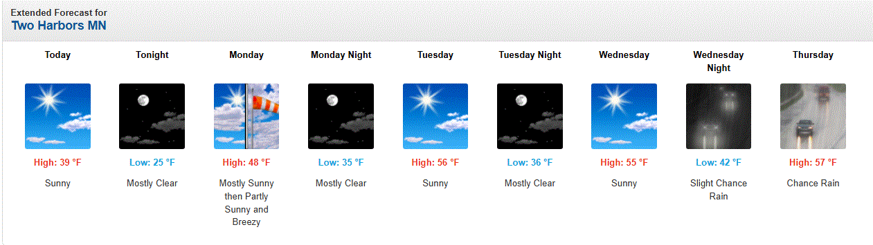
Looking good next week. Seasonable temps will feel good.
-
April 19 1928: Chilly air moves across the region with a record low of 19 at the Twin Cities. 1893: A heavy snowstorm at Bird Island would last until the 21st. 17 inches of snow would fall, with drifts 3 to 4 feet high. 1820: The first tornado ever reported in Minnesota hits the camp that would soon become Ft. Snelling. It damages the roof of a barracks, with no one injured. For Sunday, April 19, 2026 1775 - The first engagement of the Revolutionary War took place under clear crisp weather at Lexington-Concord. (Sandra and TI Richard Sanders - 1987) 1941 - The temperature at Sodus, NY, soared to 95 degrees. The next day Albany, NY, reported a record for April of 93 degrees. (The Weather Channel) 1973 - Glenrock, WY, received 41 inches of snow in just 24 hours, and a storm total of 58 inches, to establish two state records. (18th-20th) (David Ludlum) (The Weather Channel) 1976 - The northeastern U.S. was in the midst of an early season heat wave, and the Boston Marathon took place in 90 degree heat. At Providence RI the mercury hit 98 degrees. (David Ludlum) 1987 - Forty cities in the central U.S. reported new record high temperatures for the date as readings soared into the 80s and lower 90s for Easter Sunday. Fort Smith AR reported a record high of 95 degrees. (The National Weather Summary) 1988 - Severe thunderstorms over the southeastern U.S. early in the day spawned a strong (F-3) tornado which destroyed seventeen homes and severely damaged thirty houses near Madison FL killing four persons and injuring eighteen others. (Storm Data) (The National Weather Summary) 1989 - A dozen cities in the southwestern U.S. reported new record high temperatures for the date. The afternoon high of 98 degrees at Hanksville UT equaled their record for April. Tucson AZ reported their earliest 100 degree reading of record. (The National Weather Summary) 1990 - Five cities in the northeastern U.S. reported record low temperatures for the date as readings dipped into the 20s and upper teens. Elkins WV reported a record low of 20 degrees. Thunderstorms over the Southern Plains produced golf ball size hail at San Angelo TX, and up to four inches of rain in southwestern Oklahoma. (The National Weather Summary) (Storm Data) 1996 - One of the most memorable tornado outbreaks in Illinois history occurred on April 19, 1996. During the day, 33 tornadoes were reported as supercells erupted and moved across the state during the afternoon and evening hours. Wind estimates in excess of 170 mph were associated with some of the stronger tornadoes, one of which ripped through nearby Ogden, IL. (University of Illinois WW2010)
-
April 18 2004: A strong cold front whips up winds of up to 55 miles an hour over southern Minnesota. The wind causes black clouds of soil to lift into the air, creating soil erosion and reduced visibility. Some old-timers remarked that it reminded them of the dust storms from the 1930's Dust Bowl era. 2002: Baseball-sized hail falls in Eagan, creating small craters in the soft ground and broken windows in apartments. 1977: A tornado touches down at the mouth of the Minnesota River. For Saturday, April 18, 2026 1880 - More than two dozen tornadoes were reported from Kansas and Arkansas to Wisconsin and Michigan. More than 100 persons were killed, including 65 persons at Marshfield MO. (David Ludlum) 1906 - A severe earthquake shook San Francisco, and unusual easterly winds spread fires destroying the city. (David Ludlum) 1944 - California experienced its worst hailstorm of record. Damage mounted to two million dollars as two consecutive storms devastated the Sacramento Valley destroying the fruit crop. (The Weather Channel) 1957 - A dust devil near Dracut MA lifted a small child three feet into the air, and rolled two other children on the ground. Fortunately none of the three were hurt. The dust devil was accompanied by a loud whistling sound as it moved westward. (The Weather Channel) 1970 - Rapid City, SD, received a record 22 inches of snow in 24 hours. (17th-18th) (The Weather Channel) 1987 - Thirty-one cities in the central U.S. reported record high temperatures for the date, including International Falls MN with a reading of 88 degrees, and Bismarck ND with a high of 92 degrees. A sharp cold front produced high winds in the western U.S. Winds in Utah gusted to 99 mph at the Park City Angle Station, and capsized a boat on Utah Lake drowning four persons. (The National Weather Summary) (Storm Data) 1988 - Afternoon and evening thunderstorms produced large hail and damaging winds in the southeastern U.S. A strong (F-2) tornado severely damaged seventeen mobile homes near Bainbridge GA injuring three persons. (The National Weather Summary) (Storm Data) 1989 - Thunderstorms produced large hail and damaging winds in Texas, Oklahoma and Arkansas. A thunderstorm in Pecos County of southwest Texas produced wind gusts to 90 mph at Imperial. (Storm Data) (The National Weather Summary) 1990 - Heavy snow blanketed the west central valleys and southwest mountains of Colorado with up to 18 inches of snow. Nine cities from the Mid Mississippi Valley to the Middle Atlantic Coast Region reported record low temperatures for the date, including Fort Wayne IND with a reading of 23 degrees. (The National Weather Summary) (Storm Data)
-
Picked up 0.50" of rain yesterday around here with the initial stm dropping hail up to 1.5" in size, the core of which just missed me to the S & E. Just pea hail imby. Cold weekend on tap. Lows in the 10's/20's this morning. EDIT: Just now saw my first robin
-
Reports of 1" - 1.5" hail that scooted just E of my location on the shore. Just missed it.
-
Another resident in town mPinged 1" hail near the shoreline EDIT: 0.75" hail
-
Pea hail with hvy rain
-
Stms moving into my area. Lots of hail sigs with these.
-
April 17 1965: The Mississippi River at St. Paul has a record crest, 4 feet above the previous record. High water records would be set all the way down to Missouri in later days. For Friday, April 17, 2026 1922 - A family of at least six tornadoes caused death and destruction along parts of a 210 mile path from north of Ogden IL to Allen County OH, killing sixteen persons. A post card, picked up in Madison County IN, was found 124 miles away near Mount Cory OH. (The Weather Channel) 1953 - One of the few severe hailstorms accompanied by snow, sleet, glaze, and rain, pelted parts of Kay, Osage, Creek, Tulsa, Washington, and Rogers Counties in northeastern Oklahoma late in the day. Nearly 10,000 insurance claims were filed. (The Weather Channel) 1965 - The Mississippi River reached a flood crest at Saint Paul MN four feet higher than any previous mark. During the next two weeks record levels were reached along the Mississippi between Saint Paul and Hannibal MO. Flooding caused more than 100 million dollars damage, but timely warnings kept the death toll down to just twelve persons. (David Ludlum) 1987 - Twenty-two cities in the central U.S. reported new record high temperatures for the date. Temperatures warmed into the 70s and 80s from the High Plains Region to the Mississippi Valley, with readings in the low 90s reported in the Southern Plains Region. Tulsa OK hit 92 degrees. (The National Weather Summary) 1988 - Heavy snow blanketed northern Arizona. Snowfall totals ranged up to 16 inches at Pinetop, with 10 inches reported at Flagstaff. Afternoon thunderstorms spawned a couple of tornadoes in Idaho. (The National Weather Summary) (Storm Data) 1989 - Arctic cold invaded the north central U.S. Missoula MT was blanketed with four inches of snow, and Glasgow MT reported a record cold morning low of 14 degrees above zero. (Storm Data) (The National Weather Summary) 1990 - High winds in northern Utah, gusting to 90 mph in Weber County, blew a trampoline through a living room window, and strong winds associated with a cold front crossing the Middle Atlantic Coast Region gusted to 75 mph in the Chesapeake Bay area of Virginia. Unseasonably cold weather prevailed in the north central U.S. Valentine NE was the cold spot in the nation with a record low of 10 degrees. (The National Weather Summary) (Storm Data) Top 10 crests at St. Paul: 1. 26.01 ft on 04-16-1965 2. 24.52 ft on 04-15-1969 3. 23.76 ft on 04-18-2001 4. 23.20 ft on 04-30-2001 5. 22.37 ft on 04-13-1997 6. 22.02 ft on 04-16-1952 7. 20.19 ft on 03-31-2019 8. 20.17 ft on 06-29-2024 (P) 9. 20.13 ft on 06-26-2014 10. 19.15 ft on 06-26-1993
-
60's - 70's away from lake. 30's-40's along the shore. Cold lake breeze. Top 5 warmth inland today.
-
Looking at the TH co-op, they've only measured 2.69" YTD, but the CoCoRahs site at Flood Bay NE of town has 6.43". Other sites in the area around here are about the same or more. Issues there at the co-op.
-
April 16 1939: A rain, snow, sleet and ice storm begins across southern Minnesota. Despite many phone and power outages, farmers are jubilant that the storm brings needed moisture. For Thursday, April 16, 2026 1851 - The famous "Lighthouse Storm" raged near Boston Harbor. Whole gales and gigantic waves destroyed Minot Light with its two keepers still inside. The storm resulted in great shipping losses and coastal erosion. (David Ludlum) 1880 - A tornado near Marshall, MO, carried the heavy timbers of an entire home a distance of twelve miles. (The Weather Channel) 1933 - Franklin Lake, NH, was buried under 35 inches of snow. (Sandra and TI Richard Sanders - 1987) 1960 - A wind gust of 70 mph was measured at the Stapleton International Airport in Denver CO, their highest wind gust of record. (The Weather Channel) 1987 - A slow moving storm system produced heavy rain over North Carolina and the Middle Atlantic Coast States. More than six inches of rain drenched parts of Virginia, and flooding in Virginia claimed three lives. Floodwaters along the James River inundated parts of Richmond VA. (The National Weather Summary) (Storm Data) 1988 - A storm in the northeastern U.S. produced a foot of snow at Pittsburg VT. Severe thunderstorms produced baseball size hail and spawned five tornadoes in the Southern High Plains Region. (The National Weather Summary) (Storm Data) 1989 - A cold front, ushering sharply colder air into the north central U.S., brought snow to parts of Montana and North Dakota. At midday the temperature at Cutbank MT was just 22 degrees. (The National Weather Summary) (Storm Data) 1990 - Thunderstorms developing along a stationary front produced large hail and damaging winds across Oklahoma, with 99 reports of large hail and damaging winds during the evening and early nighttime hours. Thunderstorms produced baseball size hail south of Carney, and wind gusts to 100 mph in the Oklahoma City area which swept away many Federal tax returns being transported from a mail cart to a waiting truck about the time of the midnight deadline. Will Rogers Airport in Oklahoma City reported a record wind gust of 92 mph. (The National Weather Summary) (Storm Data)
-
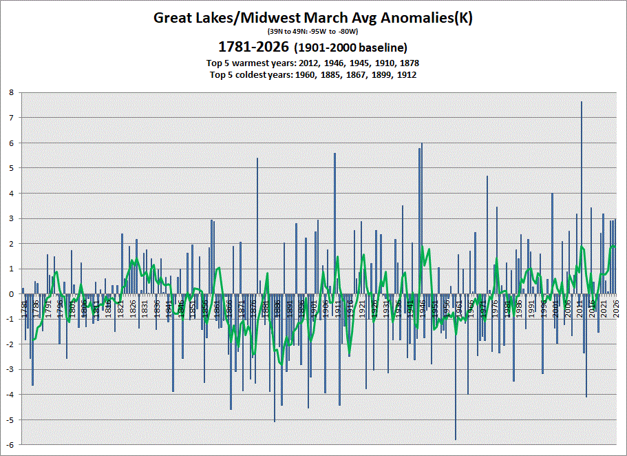
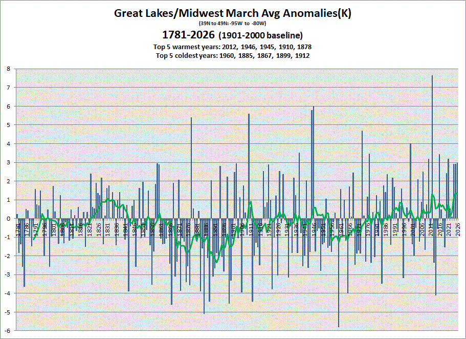
Early data in for March. Another warm one. 5 & 10 yr trend charts shown respectively.
-
Well, it is still April in the Northland. Bouts of chilly wx still in the pipeline.
-
Eeked out about 0.10" of rain yesterday from the heavy drizzle, and shwrs/stms that developed over the area. Was nice to have stms for a change. Geese have been trickling back into the area as well as flocks of tweety birds. No robin sightings yet, but that'll come soon.
-
April 15 2002: An early heat wave overtakes Minnesota. Faribault hits 93 degrees, and the Twin Cities would experience their earliest recorded 90 degree temperature with a high of 91. For Wednesday, April 15, 2026 1921 - Two mile high Silver Lake, CO, received 76 inches of snow in 24 hours, the heaviest 24 hour total of record for North America. The storm left a total of 87 inches in twenty-seven and a half hours. (David Ludlum) 1927 - New Orleans LA was drenched with 14.01 inches of rain, which established a 24 hour rainfall record for the state. (The Weather Channel) 1949 - A hailstone five inches by five and a half inches in size, and weighing four pounds, was measured at Troy NY. (The Weather Channel) 1958 - A tornado 300 yards in width skipped along a five mile path near Frostproof FL. A 2500 gallon water tank was found one mile from its original position (it is not known how much water was in the tank at the time). (The Weather Channel) 1987 - Thunderstorms developing along a cold front produced severe weather in the Southern Atlantic Coast Region. A tornado killed one person and injured seven others near Mount Dora FL. Drifts of hail up to two feet deep were reported in Davidson and Rowan counties in North Carolina. Myrtle Beach SC was deluged with seven inches of rain in three hours. (The National Weather Summary) (Storm Data) 1988 - Death Valley, CA, was soaked with 1.53 inches of rain in 24 hours. Snow fell in the mountains of southern California. (The National Weather Summary) (Storm Data) 1989 - Showers and thunderstorms soaked the eastern U.S. with heavy rain, pushing the rainfall total for the month at Cape Hatteras NC past their previous April record of 7.10 inches. (Storm Data) (The National Weather Summary) 1990 - Thunderstorms developing along a stationary front produced severe weather from west central Texas to west central Arkansas during the late afternoon and evening. Thunderstorms spawned a tornado which caused more than half a million dollars damage at Fort Stockton TX, produced wind gusts to 65 mph at Dennison TX, produced baseball size hail at Silo OK and near Capps Corner TX, and drenched southeastern Oklahoma with up to 4 inches of rain in two hours. (The National Weather Summary) (Storm Data) Note: The 1927 record for rainfall in 24 hrs was eclipsed on Aug 29, 1962 at 22.00" from a tropical disturbance in the Sabine National Wildlife Refuge in Hackberry, LA.
-
13.6" is the daily record which still stands for April, but stm total does go to the 2018 event.
-
April 14 1983: A 'surprise' snowstorm covers east central Minnesota. The Twin Cities receives 13.6 inches, the all-time record for April. Brilliant blue skies and bright sun appear the next morning. 1886: The deadliest tornado in Minnesota's history rips through St. Cloud and Sauk Rapids, leaving 72 people dead. 80 percent of all buildings in Sauk Rapids would be leveled as the tornado's width expanded to 800 yards. As it crossed the Mississippi it knocked down two iron spans of a wagon bridge and local witnesses said the river was 'swept dry' during the tornado crossing. 300,000 dollars damage would occur in Sauk Rapids, only 4,000 dollars of which was insured. The forecast for that day was for local rains and slightly warmer with highs in the 50's. For Tuesday, April 14, 2026 1873 - A famous Easter blizzard raged across Kansas, Nebraska and South Dakota. Gale force winds blew the wet snow into massive drifts, however there were few deaths due to the sparse population and due to the gradual increase of the storm. (David Ludlum) 1886 - A devastating tornado, 800 yards in width at times, cut a twenty mile path through Saint Cloud MN killing 74 persons. The bottom of the Mississippi River was said to have been seen during the tornado's crossing. Eleven persons were killed at a wedding party near the town of Rice. (David Ludlum) (The Weather Channel) 1987 - A storm system moving slowly northeastward across the Middle Mississippi Valley produced severe thunderstorms which spawned three tornadoes around Ottumwa IA, and produced up to four inches of rain in southeastern Nebraska, flooding rivers and streams. (The National Weather Summary) (Storm Data) 1988 - A weather disturbance off the southern coast of California brought parts of southern California their first rain in six weeks. Rain-slickened roads resulted in numerous accidents in southern California, including a ten car pile-up at Riverside. (The National Weather Summary) (Storm Data) 1989 - Late afternoon thunderstorms in northern Florida soaked the town of Golden Gate with 4.37 inches of rain in about two hours, resulting in local flooding. (The National Weather Summary) (Storm Data) 1990 - Thunderstorms developing along a cold front produced severe weather in southeastern Texas during the mid morning hours. Thunderstorms produced dime size hail at Galveston, and wind gusts to 59 mph at Port Arthur. Afternoon thunderstorms over southeast Louisiana spawned tornadoes south of Bogalusa and at Rio. (Storm Data)