Brian D
-
Posts
3,109 -
Joined
-
Last visited
Content Type
Profiles
Blogs
Forums
American Weather
Media Demo
Store
Gallery
Everything posted by Brian D
-
Missed out on any rain yesterday, and now only scattered rain possible today. Currently raining up N. A cool day on tap with highs in the 60's.
-
June 24 2002: Heavy rains fall on already saturated ground, leading to flooding. 5.50 inches fall at Delano, and half of a mobile home park at Howard Lake is evacuated due to rising water. 1972: Frost develops across northeast Minnesota. Duluth has a low of 35 and Tower bottoms out at 32. (Note: We've seen similar temps already this year in late June in NE MN.) For Wednesday, June 24, 2026 1816 - The cold weather of early June finally gave way to several days of 90 degree heat in Massachusetts, including a reading of 99 degrees at Salem. (David Ludlum) 1924 - Six men at a rock quarry south of Winston-Salem, NC, sought shelter from a thunderstorm. The structure chosen contained a quantity of dynamite. Lightning struck a near-by tree causing the dynamite to explode. The men were killed instantly. (The Weather Channel) 1951 - Twelve inches of hail broke windows and roofs, and dented automobiles, causing more than fourteen million dollars damage. The storm plowed 200 miles from Kingmand County KS into Missouri, with the Wichita area hardest hit. It was the most disastrous hailstorm of record for the state of Kansas. (David Ludlum) 1952 - Thunderstorms produced a swath of hail 60 miles long and 3.5 miles wide through parts of Hand, Beadle, Kingsbury, Miner and Jerauld counties in South Dakota. Poultry and livestock were killed, and many persons were injured. Hail ten inches in circumference was reported at Huron SD. (The Weather Channel) 1987 - Thunderstorms spawned six tornadoes in eastern Colorado. Baseball size hail was reported near Yoder, CO, and thunderstorm winds gusting to 92 mph derailed a train near Pratt, KS. The town of Gould, OK, was soaked with nearly an inch and a half of rain in just ten minutes. (The National Weather Summary) (Storm Data) 1988 - Forty-three cities reported record high temperatures for the date. Valentine NE reported an all-time record high of 110 degrees, and highs of 102 degrees at Casper, WY, 103 degrees at Reno, NV, and 106 degrees at Winnemucca, NV, were records for the month of June. Highs of 98 degrees at Logan, UT, and 109 degrees at Rapid City, SD, equaled June records. Lightning killed twenty-one cows near Conway, SC. (The National Weather Summary) (Storm Data) 1989 - Thunderstorms developing along a warm front produced severe weather from Colorado and New Mexico to Kansas and Nebraska. Thunderstorms spawned seven tornadoes, and produced wind gusts to 80 mph at Wood River, NE, and hail three inches in diameter at Wheeler, KS. (The National Weather Summary) (Storm Data) Observances: 24 Wed National Swim A Lap Day 24 Wed Farmer Day 24 Wed Fix Your Windows and Doors Day 24 Wed International Fairy Day 24 Wed International St. Johns Day 24 Wed Midsummer 24 Wed National Le Day 24 Wed National Pralines Day 24 Wed National Relationship Equity Day 24 Wed Upcycling Day
-
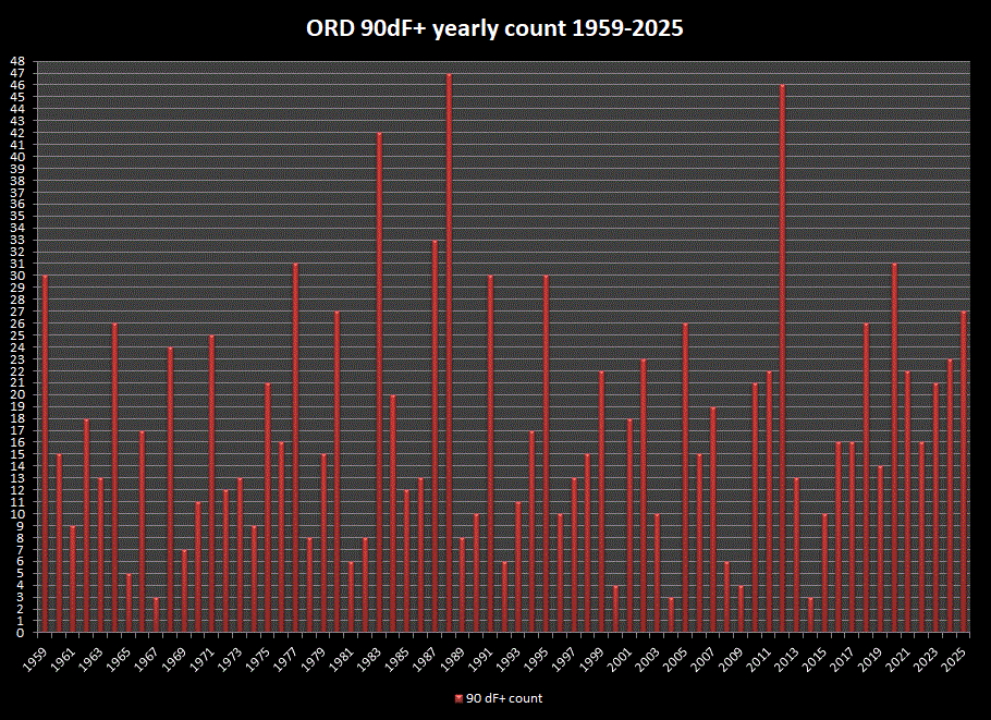
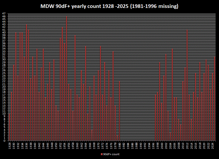
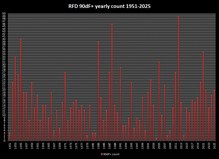
Joe, since your tracking 90dF+ days each year, thought I'd look at the longer period stns on your list, and graph the yearly counts as reference. Unfortunately, MDW has a 15 yr gap.
-
June 23 2002: Just a few weeks after torrential rains hit the area, another round of heavy rain hits northern Minnesota. This time up to eight inches would fall in a two-day period in parts of Mahnomen and St. Louis Counties. For Tuesday, June 23, 2026 1902 - The temperature at Volcano Springs, CA, soared to 129 degrees to set a June record for the U.S. (Sandra and TI Richard Sanders) 1944 - Four tornadoes killed 153 persons and caused five million dollars damage in Pennsylvania, West Virginia and Maryland. The tornadoes formed during the evening and moved southeast along parallel paths flattening everything in their way. The town of Shinnston WV was leveled, and was left with the majority of the casualties. Until that time it was believed that damaging tornadoes did not travel across mountainous terrain. (David Ludlum) 1957 - A few miles west of Fort Stockton TX, softball size hail injured 21 persons unable to find shelter, mostly farm laborers. Some livestock were killed. (The Weather Channel) 1987 - A massive hailstorm hit eastern Colorado causing an estimated 60 to 70 million dollars damage. At La Junta, CO, hail as large as softballs caused 37 million dollars damage. (Storm Data) (The National Weather Summary) 1988 - Thirty-four cities reported record high temperatures for the date. The reading of 90 degrees at Bluefield, WV, equaled their record for the month of June. The record high of 104 degrees at Billings, MT, was their thirteenth of the month. (The National Weather Summary) 1989 - Six cities in the High Plains Region reported record low temperatures for the date, including Sheridan, WY, with a reading of 38 degrees. Showers and thunderstorms in the eastern U.S. deluged New Castle County, DE, with 2.5 inches of rain in one hour. (The National Weather Summary) Observances: 23 Tue National Hydration Day 23 Tue International Women in Engineering Day 23 Tue National Typewriter Day 23 Tue National Let It Go Day 23 Tue National Pink Day 23 Tue International Widows' Day 23 Tue Let it Go Day 23 Tue National Detroit Style Pizza Day 23 Tue National Family Owned & Operated Businesses Day 23 Tue National Pecan Sandies Day 23 Tue National Porridge Day 23 Tue Pink Flamingo Day 23 Tue United Nations Public Service Day 23 Tue Olympic Day
-
Not as chilly this morning with lows in the upper 30's/40's. Highs around 70 again, but chance of rain moving later today into tonight. That will be welcome.
-
Low 30's to mid 40's across the area this morning with highs expected around 70. I'm sure there was patchy frost in some localized areas.
-
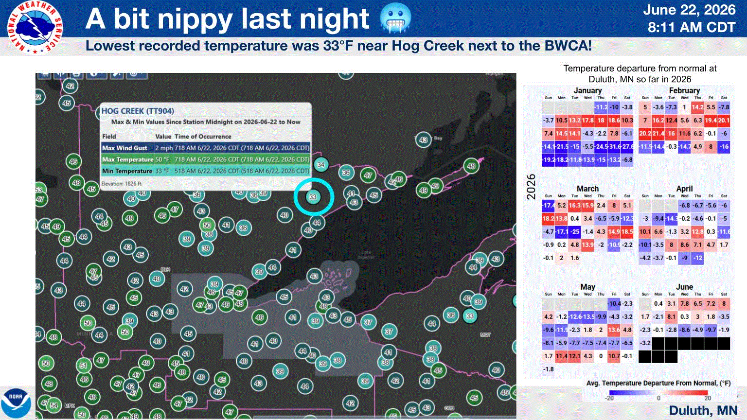
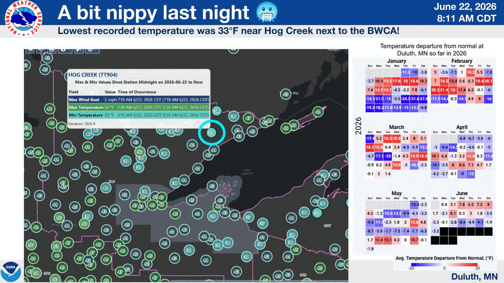
June 22 1988: Smoke fills the sky across much of Minnesota due to wild fires during the '88 drought. 1919: The 2nd deadliest tornado in Minnesota history hits Fergus Falls, killing 59 people. Like the #1 killer tornado for Minnesota (73 fatalities in St. Cloud and Sauk Rapids on 4/14/1886), it struck on a weekend. 1917: Grand Meadow has an intense downpour, and 4.98 inches of rain on this date. Corn crops are badly damaged by the heavy rain/flooding. For Monday, June 22, 2026 1947 - Twelve inches of rain fell in forty-two minutes at Holt, MO, establishing a world rainfall record. That record was tied on January 24-25, 1956, at the Kilauea Sugar Plantation in Hawaii, as their state record was established with 38 inches of rain in 24 hours. (The Weather Channel) 1972 - Hurricane Agnes deluged Pennsylvania and New York State with torrential rains resulting in the most costly flood in U.S. history. In the Middle Susquehanna Valley of Pennsylvania, 24 hour rainfall amounts were generally 8 to 12 inches, with up to 19 inches in extreme southwestern Schuylkill County. At Wilkes-Barre, PA, the dike was breached destroying much of the town. Flooding resulted in 117 deaths and 3.1 billion dollars damage. (David Ludlum) 1981 - A young woman from Lubbock, TX, was struck by lightning. The bolt of lightning struck just above her right shoulder near her neck, and passed right to left through her body, tearing her warm-ups, causing her tennis shoes to explode, and lifting her two feet into the air. (The Weather Channel) 1987 - Thunderstorms in southern Texas produced wind gusts to 116 mph near Quemado. Thunderstorms in New York State produced 5.01 inches of rain in 24 hours at Buffalo, an all-time record for that location, and produced an inch of rain at Bath, PA. The temperature at Fairbanks AK soared to 92 degrees, establishing a record for the date. (The National Weather Summary) (Storm Data) 1988 - Sixty-five cities in twenty-four states reported record high temperatures for the date. Tucson AZ reported an all-time record high of 114 degrees, surpassing the previous record of 112 degrees established a day earlier. Highs of 98 degrees at Pittsburgh, PA, and 100 degrees at Baltimore, MD, tied records for the month of June. (The National Weather Summary) 1989 - Record cold temperatures were reported in the High Plains Region. Rapid City, SD, reported a record low of 39 degrees, in sharp contrast to their record high of 102 degrees two days earlier, on the 20th. (The National Weather Summary) Observances: 22 Mon National Limoncello Day 22 Mon National Onion Ring Day 22 Mon National Chocolate Eclair Day 22 Mon World Rainforest Day 22 Mon National HVAC Tech Day 22 Mon National Pet Choking Prevention Day 22 Mon Positive Media Day
-
Chilly morning with temps ranging from the mid 30's to upper 40's. Another nice day on tap with temps around 70.
-
Happy Father's Day to all you dads!
-
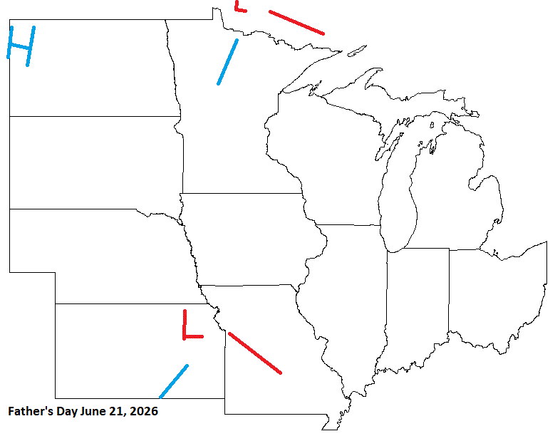
June 21 1989: Fairmont has a wind gust of 76 mph during a severe thunderstorm. For Sunday, June 21, 2026 1893 - On the first day of summer the temperature at Dodge City, KS, soared to 106 degrees during the midst of a blistering heat wave. The heat wave initiated a severe three year drought in the Central Plains Region. Ironically, at about the same time, heavy rains in the Mississippi Valley were causing the river to swell to its highest level of record at New Orleans, LA. (David Ludlum) (The Weather Channel) 1919 - Seven heavy coach cars of a moving train were picked up and thrown from the tracks by tornado winds. A baggage car was set down thirty feet away from the rest of the train. (The Weather Channel) 1954 - A severe hailstorm struck Wichita KS and vicinity causing nine million dollars damage. (The Weather Channel) 1972 - Phoenix, AZ, was drenched with 1.64 inches of rain late on the 21st and early on the 22nd to easily surpass their previous June rainfall record of 0.95 inches. The total for the month was 1.70 inches. (The Weather Channel) 1987 - A tornado destroyed 57 mobile homes at the Chateam Estates trailer park northwest of Detroit, MI, killing one person and injuring six others. Total damage was estimated at 1.7 million dollars. Thunderstorms over Lower Michigan also drenched the Saginaw Valley with up to 4.5 inches of rain in less than six hours. (The National Weather Summary) (Storm Data) 1988 - The first full day of summer was a torrid one, with afternoon highs of 100 degrees or above reported from the Northern and Central Plains to the Ohio Valley. Sixty-nine cities in the north central U.S. reported record high temperatures for the date. The high of 110 degrees at Sioux Falls, SD, was an all-time record for that location. Highs of 103 degrees at Des Moines, IA, 102 degrees at Fort Wayne, IN, 109 degrees at Huron, SD, 108 degrees at Sioux City, IA, and 101 degrees at South Bend IN were records for June. (The National Weather Summary) 1989 - The first day of summer heralded snow in the northern and central Rockies. In Colorado, 15 inches of snow was reported at the summit of Mount Evans and, in Wyoming, 18 inches was reported at Dickensen Park, west of Lander. Heavy rain continued in the eastern U.S. Huntsville, AL, reported a record 11.65 inches for the month, compared to the 0.17 inch rainfall total in June 1988. (The National Weather Summary) (Storm Data) 2005 - A slow-moving thunderstorm dumped up to a foot of hail in southeastern portions of Colorado Springs, Colorado. Snowplows had to be used to clear a route through a major thoroughfare in the city. Heavy rainfall from the storm left up to 4 feet of water in city streets, trapping dozens of motorists (Associated Press). Observances: 21 Sun National Selfie Day 21 Sun Go Skateboarding Day 21 Sun Father's Day 21 Sun National Daylight Appreciation Day 21 Sun International Day of the Celebration of the Solstice 21 Sun National Arizona Day 21 Sun National Cookie Dough Day 21 Sun National Day of the Gong 21 Sun National Dog Party Day 21 Sun National Peaches and Cream Day 21 Sun National Seashell Day 21 Sun National Smoothie Day 21 Sun National Yard Games Day 21 Sun Shades for Migraine 21 Sun Siding Check Day 21 Sun World Giraffe Day 21 Sun World Humanist Day 21 Sun World Hydrography Day 21 Sun World Day of Music 21 Sun World MotorCycle Day 21 Sun International Yoga Day
-
I believe they have had some pretty hot wx over that way already this summer, and even Antarctica had very mild winter wx, too, for a couple weeks. And yet the Arctic is staying colder than normal with a persistent LP over the pack based on DMI data over the last month or so. Interesting tid bits.
-
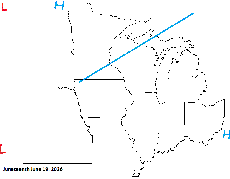
June 20 1992: Abnormally cold conditions occur across the north. Temperatures drop to 26 at Embarrass, MN and Hayward, WI, but the cold spot is 24 at Brimson, MN. For Saturday, June 20, 2026 1682 - A major tornado ripped through southwestern Connecticut, passing through Stratford, Milford, and New Haven, and then into Long Island Sound. (Sandra and TI Richard Sanders - 1987) 1921 - Circle, MT, received 11.5 inches of rain in 24 hours, a record for the state. The town of Circle received a total of 16.79 inches of rain that month to establish a rainfall record for any town in Montana for any month of the year. (The Weather Channel) 1928 - A farmer near Greensburg, KS, looked up into the heart of a tornado. He described its walls as rotating clouds lit with constant flashes of lightning and a strong gassy odor with a screaming, hissing sound . (The Weather Channel) (Note: Just incredible, and a very rare occurrence) 1964 - A squall line producing large hail swept through central Illinois. A second squall line moved through during the early morning hours of the 21st, and a third one moved through shortly after dawn. The series of hailstorms caused nine million dollars damage. Hailstones as large as grapefruit caused heavy damage to trees, utility lines, crops and buildings. The thunderstorms also produced as much as five inches of rain in an eight hour period. (David Ludlum) 1987 - Thunderstorms prevailed east of the Rockies, producing severe weather in the Central High Plains Region. Thunderstorms spawned four tornadoes in Colorado, and produced wind gusts to 70 mph at Goodland, KS. (The National Weather Summary) (Storm Data) 1988 - Thirty-eight cities in the central U.S. reported record high temperatures for the date. Afternoon highs of 97 degrees at Flint, MI, and 104 degrees at Chicago, IL, equaled records for the month of June. Thunderstorms in North Dakota produced baseball size hail near Kief, and wind gusts to 100 mph near McGregor. (Storm Data) (The National Weather Summary) 1989 - An early morning thunderstorm produced wind gusts to 61 mph at Pierre, SD, and the hot thunderstorm winds raised the temperature from 86 degrees at midnight to 96 degrees by 1 AM, and 104 degrees by 2 AM. Butte, MT, and Yellowstone Park, WY, reported snow that afternoon. (The National Weather Summary) (Storm Data) Observances: (Note: Summer Solstice starts later today into tomorrow 0825 UTC.) 20 Sat Ugliest Dog Day 20 Sat American Eagle Day 20 Sat International Surfing Day 20 Sat World Juggling Day 20 Sat World Refugee Day 20 Sat West Virginia Day 20 Sat Summer Solstice 20 Sat Clear Your Drains Day 20 Sat National Celluma Light Therapy Day 20 Sat National Hike with a Geek Day 20 Sat National Ice Cream Soda Day 20 Sat National Vanilla Milkshake Day 20 Sat National West Virginia Day 20 Sat Nystagmus Awareness Day 20 Sat World Productivity Day
-
0.02" of rain in town yesterday. Not as chilly this morning with lows in the low 40's to low 50's. Highs around 70 today.
-
Looks like a timing issue with my forecast for today, and the N front on Father's Day will be hanging back in the N Plains. Overall did OK. Watchin that LP for Father's Day tho. Could be another decent hit for the S sub.
-
Chilly morning across the Northland with temps running from the low 30's to mid 40's (top 5 chill for some) with upper 40's along the shore. Rain moving in for the aftrn, which will be nice, with highs around 65-70.
-
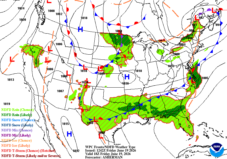
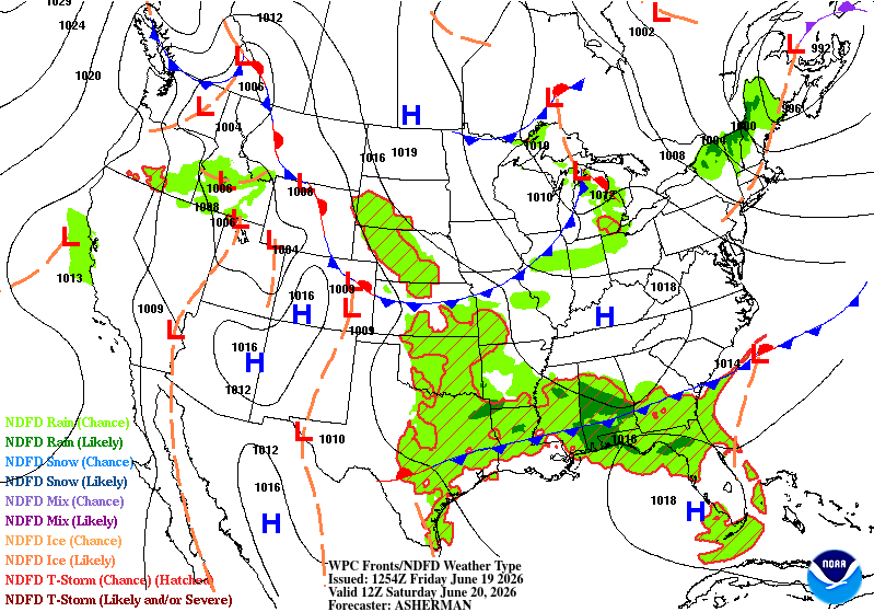
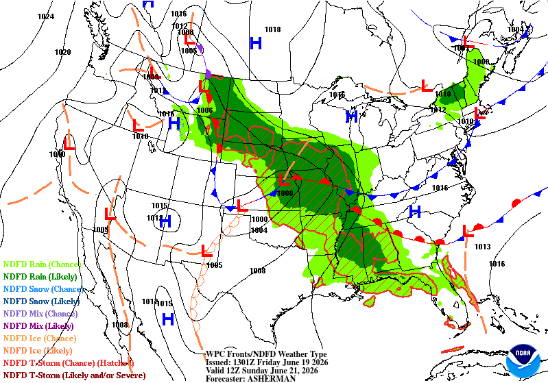
June 19 2014: Heavy rain leads to widespread flooding in the Twin Cities metro area. Minnehaha Creek has its record crest of 17.64 feet on this date. Eden Prairie records 5.47 inches of rain, while MSP airport receives 4.13 inches, the highest daily total in 5 years. 1955: Hailstones the size of hen's eggs fall in Roseau County. For Friday, June 19, 2026 1835 - A tornado tore through the center of New Brunswick NJ killing five persons and scattering debris as far as Manhattan Island. The tornado provided the first opportunity for scientists to study firsthand the track of such a storm. (David Ludlum) 1938 - A cloudburst near Custer Creek, MT, (near Miles City) caused a train wreck killing forty-eight persons. An estimated four to seven inches of rain deluged the head of the creek that evening, and water flowing through the creek weakened the bridge. As a result, a locomotive and seven passenger cars plunged into the swollen creek. One car, a tourist sleeper, was completely submerged. (David Ludlum) 1972 - Hurricane Agnes moved onshore near Cape San Blas FL with wind gusts to 80 mph, and exited Maine on the 26th. There were 117 deaths, mainly due to flooding from North Carolina to New York State, and total damage was estimated at more than three billion dollars. Up to 19 inches of rain deluged western Schuylkill County PA. The rains of Hurricane Agnes resulted in one of the greatest natural disasters in U.S. history. Agnes caused more damage than all other tropical cyclones in the previous six years combined (which included Celia and Camille). (David Ludlum) (The Weather Channel) 1987 - It was a warm June day, with plenty of thunderstorms east of the Rockies. Lightning knocked out power at Throckmorton, TX, and ignited an oil tank battery. A woman in Knox City TX was struck by lightning while in her car, and a man was struck by lightning near his home in Manatee County FL. Strong thunderstorm winds overturned several outhouses near Bixby OK, but no injuries were reported. (The National Weather Summary) (Storm Data) 1988 - Temperatures soared above 100 degrees in the central U.S. for Father's Day. Fifteen cities reported record high temperatures for the date. Severe thunderstorms in Minnesota and Wisconsin produced softball size hail near River Falls WI, and wind gusts to 80 mph at Menomonie WI. (The National Weather Summary) (Storm Data) 1989 - Fourteen cities reported record high temperatures for the date as searing heat spread from the southwestern deserts into the High Plains Region. Record highs included 98 degrees at Billings, MT, 107 degrees at Valentine, NE, and 112 degrees at Tucson, AZ. (The National Weather Summary) 1990 - What would eventually be known as the "Inland Hurricane" struck south central Kansas. This storm system produced a swath of 65 to 120 mph winds across six counties and caused $80 million dollars in damage. The peak recorded wind gust was 116 mph, which reaches low-end category 3 on the Saffir-Simpson hurricane wind intensity scale. On the enhanced Fujita Scale the 116mph winds would be rated an EF2. The storm knocked out power to all the Wichita TV stations, and they were off the air for hours. All but one of the Wichita Radio Stations, including the Wichita NOAA Weather Radio Station KEC-59, was knocked off the air. (National Weather Service Wichita) 2006 - Up to 11 inches of rain fell in the Houston, Texas area, causing widespread flash flooding. The Houston Fire Department rescued more than 500 people from flood waters, but no serious injuries or fatalities were reported. Observances: 19 Fri Juneteenth 19 Fri National Garfield the Cat Day 19 Fri National Martini Day 19 Fri World Sauntering Day 19 Fri Take A Road Trip Day 19 Fri Find a Leak Day 19 Fri International Box Day 19 Fri International Day for the Elimination of Sexual Violence in Conflict 19 Fri National FreeBSD Day 19 Fri National Watch Day 19 Fri World Sickle Cell Day
-
June 18 1939: A deadly tornado hits Anoka. 9 fatalities and over 200 injuries are reported. Note: Adding the devastating Siren, WI EF-3 tornado on this date in 2001. My brother-in-law came from there, and has family there. They were unharmed. Read about it here: https://www.weather.gov/dlh/010618_severewx 1850: Territorial Governor Ramsey reports that about halfway between Ft. Ripley and Ft. Snelling on the Mississippi a severe hail storm occurred in the evening. One or two hailstones picked up were as large as hen’s eggs and he thought he saw one about the size of a 'musket ball.' For Thursday, June 18, 2026 1875 - A severe coastal storm or possible hurricane struck the Atlantic coast from Cape Cod to Nova Scotia. Eastport ME reported wind gusts to 57 mph. (David Ludlum) 1958 - Hailstones up to four inches in diameter killed livestock as a storm passed from Joliet to Belfry in Carbon County MT. (The Weather Channel) 1970 - Wind and rain, and hail up to seven inches deep, caused more than five million dollars damage at Oberlin KS. (The Weather Channel) 1987 - It was a hot day in the Upper Great Lakes Region. Nine cities in Michigan and Wisconsin reported record high temperatures for the date. The high of 90 degrees at Marquette, MI, marked their third straight day of record heat. Severe thunderstorm in the Northern and Central High Plains Region spawned half a dozen tornadoes in Wyoming and Colorado. Wheatridge, CO, was deluged with 2.5 inches of rain in one hour. (The National Weather Summary) (Storm Data) 1988 - Severe thunderstorms in eastern North Dakota and northern Minnesota produced hail three inches in diameter and spawned four tornadoes in Steele County. Thunderstorms also produced wind gusts to 80 mph at Clearbrook MN. (The National Weather Summary) (Storm Data) 1989 - Unseasonably hot weather prevailed in the southwestern U.S. In Arizona, afternoon highs of 103 degrees at Winslow, 113 degrees at Tucson, and 115 degrees at Phoenix were records for the date. (The National Weather Summary) Observances: 18 Thu International Picnic Day 18 Thu International Panic Day 18 Thu International Sushi Day 18 Thu Clean Your Aquarium Day 18 Thu International Day for Countering Hate Speech 18 Thu Lock Check Day 18 Thu National Cherry Tart Day 18 Thu National Black America’s Day of Repentance 18 Thu National Fishing Day 18 Thu National Splurge Day 18 Thu National Wanna Get Away Day 18 Thu Sustainable Gastronomy Day 18 Thu Wear BLUE Day
-
0.40" from that steady light rain yesterday. High of 50 here in town was 2nd coldest low max behind 46 in 1944. It was very chilly out. But nice wx today with highs around 70.
-
45-50 along the shore with a Lake breeze, and a steady -RN. Very mid Fallish/mid Springish wx.
-
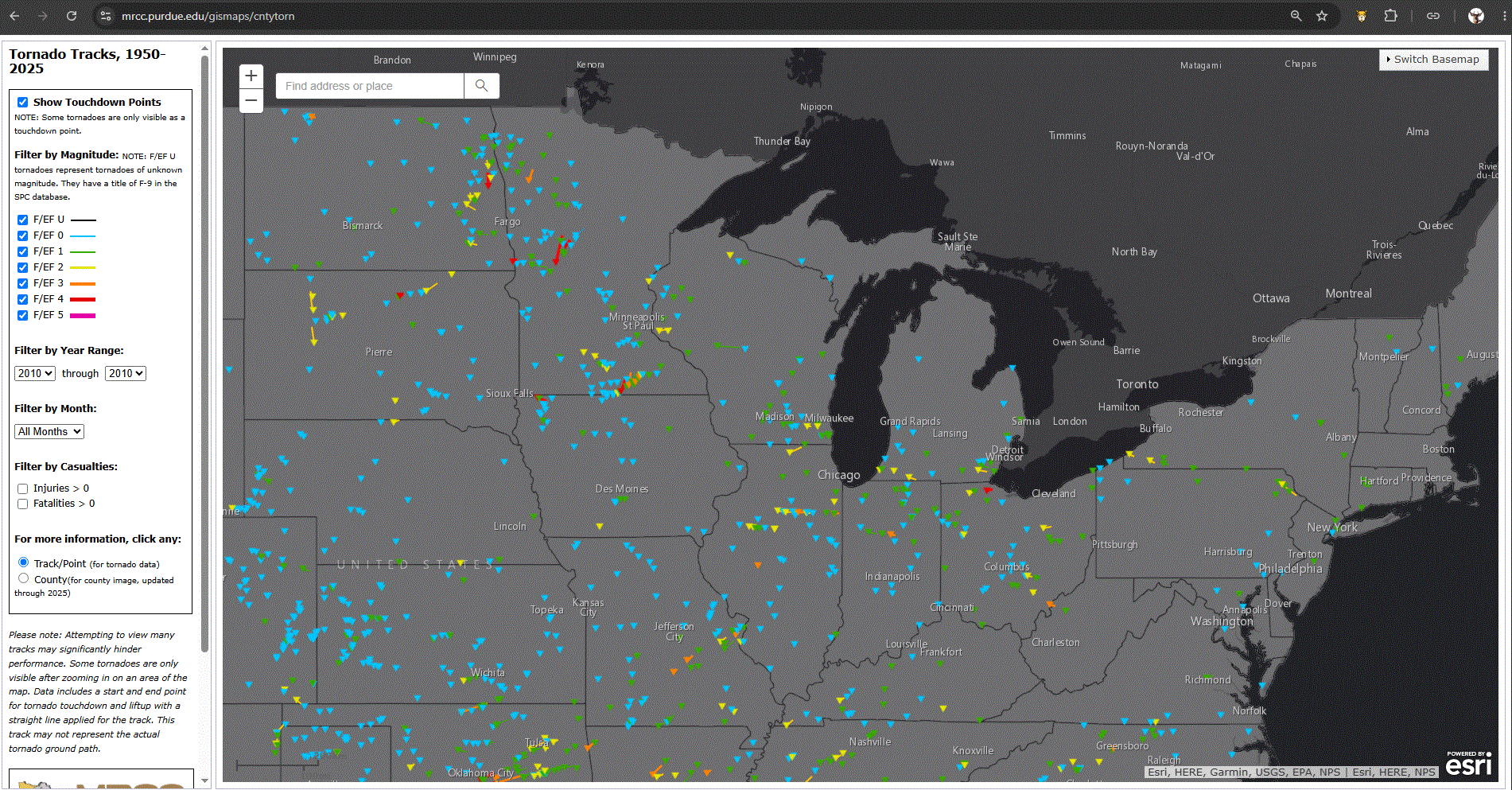
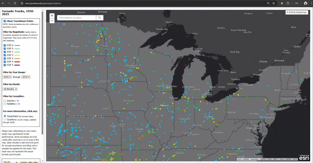
June 17 2010: The largest single-day tornado outbreak in Minnesota history occurs with 48 tornadoes across the state. This outbreak would set the stage for a record breaking tornado year in Minnesota that finished with 113 tornadoes, the most of any state in the US that year. There were three EF-4 tornadoes and four EF-3 tornadoes in Minnesota. Four tornado fatalities occurred, which was the highest daily number since July 5, 1978. (Note: Very impressive record, and quite unusual.) For Wednesday, June 17, 2026 1859 - Hot Santa Ana winds in southern California roasted fruit on one side in the trees at Santa Barbara. (Sandra and TI Richard Sanders - 1987) 1882 - A tornado traveled more than 200 miles across the state of Iowa killing 130 persons. The tornado touched down about ninety miles west of Grinnell, and struck the town and college around sunset, killing sixty persons, and causing more than half a million dollars damage. Traveling at nearly 60 mph, the tornado hit Mount Pleasant about 11 PM causing another half a million dollars damage. (David Ludlum) 1965 - Holly, CO, was deluged with 11.08 inches of rain to establish a state 24 hour rainfall record. (The Weather Channel) 1987 - Thunderstorms produced severe weather in the south central U.S. Thunderstorms in Kansas produced wind gusts to 76 mph at Lyons, and baseball size hail at Garden City. The Edwards Aquifer, which supplies water to San Antonio, TX, reached a record level of 699.2 feet following a record 18.43 inches of rain in thirty days. Torrential rains between the mid May and mid June sent 8.8 million acre feet of water down the rivers of southern Texas, the largest volume in 100 years of records. (The National Weather Summary) (Storm Data) 1988 - Thunderstorms produced large hail and damaging winds in Georgia and the Carolinas. Thunderstorm winds gusted to 75 mph at Eden, NC. (The National Weather Summary) (Storm Data) 1989 - Unseasonably cool air, responsible for 37 record lows in the central U.S. on the 15th and 16th, including a low of 33 degrees at Valentine NE on the 15th, overspread the eastern U.S. ending a three day siege of severe weather. (The National Weather Summary) Observances: 17 Wed World Day to Combat Desertification and Drought 17 Wed Bunker Hill Day 17 Wed Clean Your Kitchen Vents Day 17 Wed Gerald Day 17 Wed National Dump the Pump Day 17 Wed National Harrison Day 17 Wed National Jan Day 17 Wed National Ralph Day 17 Wed National Stewart’s Root Beer Day 17 Wed Nursing Assistants Day 17 Wed World Tessellation Day 17 Wed National Apple Strudel Day 17 Wed Global Garbage Man Day 17 Wed National Eat Your Vegetables Day 17 Wed National Mascot Day
-
Showers this morning here with a T in town so far, but NC MN got a bit more and they need it being in a D2 drought. Hoping for a wet day across the area. Will be chilly along the shore with NE winds off the Lake. Highs upper 50's/low 60's.
-
June 16 1992: A total of 27 tornadoes touch down across Minnesota, the second most in Minnesota history. The communities of Chandler, Lake Wilson, Clarkfield and Cokato are badly damaged. 80 million dollars worth of damage would occur, and Presidential disaster declarations would be made for many counties. 1989: Frost develops across Minnesota with crops destroyed on high ground in southeast Minnesota. Preston got down to 32. For Tuesday, June 16, 2026 1806 - A total eclipse of the sun was viewed from southern California to Massachusetts. (David Ludlum) 1917 - The temperature soared to 124 degrees at Mecca climaxing the most destructive heat wave of record in California history. (David Ludlum) 1944 - A tornado in Sioux City, IA, traveled an odd course. It spun in one place for about twenty minutes, made a U-turn, traveled southeast for about three miles, then traveled south, east, north, and finally east again. (The Weather Channel) 1987 - Temperatures soared above 100 degrees in the Upper Midwest, reaching 104 degrees at Lincoln, NE. Thunderstorms produced wind gusts to 96 mph at Valley City, ND, and baseball size hail near Red Oak, IA. (The National Weather Summary) (Storm Data) 1988 - After a brief respite, hot weather returned to the Northern High Plains Region. Late night thunderstorms in Montana produced wind gusts to 70 mph at Polson and north of Lake Seeley. (The National Weather Summary) (Storm Data) 1989 - Daytime thunderstorms produced severe weather from northern Florida to the Middle Atlantic Coast. The thunderstorms spawned eight tornadoes, and there were 138 reports of large hail and damaging winds. Thunderstorm winds gusting to 87 mph caused twenty million dollars damage at Columbia SC. Strong thunderstorm winds killed one person at McLeansville NC. (Storm Data) (The National Weather Summary) Observances: 16 Tue National Fudge Day 16 Tue Islamic New Year 16 Tue Bloomsday 16 Tue International Day of the African Child 16 Tue Arborist Appreciation Day 16 Tue International Day of Family Remittances 16 Tue International WaterFall Day 16 Tue World Sea Turtle Day 16 Tue Fresh Veggies Day 16 Tue Muharram
-
0.15" of rain yesterday evening. Was a very nice day. Today will be cooler with highs in the 60's, and hopefully a very wet day tomorrow. Running behind in the precip curve.
-
Beautiful day with temps hovering around 80, and dews around 50.
-
June 15 1989: Scattered frost develops across Minnesota, with the coldest reading of 29 at Isabella. For Monday, June 15, 2026 1662 - A fast was held at Salem MA with prayers for rain, and the Lord gave a speedy answer. (David Ludlum) 1879 - McKinney ND received 7.7 inches of rain in 24 hours, a state record. (The Weather Channel) 1896 - The temperature at Fort Mojave, CA, soared to 127 degrees, the hottest reading of record for June for the U.S. The low that day was 97 degrees. Morning lows of 100 degrees were reported on the 12th, 14th and 16th of the month. (The Weather Channel) (Note: BRUTAL!) 1953 - Dust devils are usually rather benign weather phenomena, however, two boys were injured by one near Prescott AZ. One of the boys suffered a black eye, and the other boy had two vertebrae fractured by wind-blown debris. (The Weather Channel) 1957 - East Saint Louis was deluged with 16.54 inches of rain in 24 hours, a record for the state of Illinois. (The Weather Channel) 1987 - Thunderstorms developing along a cold front produced severe weather in the northwestern U.S. A tornado damaged five homes and destroyed a barn near Salmon ID. It lifted a metal shed 100 feet into the air, and deposited it 100 yards away. Hail an inch and a half in diameter caused ten million dollars damage to automobiles at Nampa ID. (The National Weather Channel) (Storm Data) 1988 - Severe thunderstorms in the Central High Plains Region spawned five tornadoes around Denver, CO, in just one hour. A strong (F-3) tornado in southern Denver injured seven persons and caused ten million dollars damage. Twenty-six cities in the eastern U.S. reported record high temperatures for the date. The high of 97 degrees at Portland ME was a record for June. (Storm Data) (The National Weather Summary) 1989 - Thunderstorms produced severe weather over the Southern and Middle Atlantic Coast States. The thunderstorms spawned eight tornadoes, including strong (F-3) tornadoes which injured three persons at Mountville PA and four persons at Columbia, PA. There were 111 reports of large hail and damaging winds, including wind gusts to 80 mph at Norfolk, VA, and Hogback Mountain, SC. (The National Weather Summary) (Storm Data) Observances: 15 Mon National Take Your Cat to Work Day 15 Mon World Elder Abuse Awareness Day 15 Mon Nature Photography Day 15 Mon Clean Your Vents Day 15 Mon National Prune Day 15 Mon Sneak A Kiss Day 15 Mon YMA Day 15 Mon Global Wind Day