Brian D
-
Posts
3,023 -
Joined
-
Last visited
Content Type
Profiles
Blogs
Forums
American Weather
Media Demo
Store
Gallery
Everything posted by Brian D
-
Picked up 0.11" of rain this morning. Meager, so hopefully more to come later today.
-
June 4 1935: The latest official measurable snowfall in Minnesota falls at Mizpah on this date with 1.5 inches. For Thursday, June 4, 2026 1825 - A hurricane struck Long Island NY leveling trees and causing damage to ships. The early season hurricane, which originated around Cuba, caused major damage along the Atlantic coast from Charleston SC to New York City. Many were lost at sea. (David Ludlum) 1860 - Iowa's Commanche Tornado , with wind speeds estimated in excess of 300 mph, was unquestionably one of the worst experienced by early settlers, with nearly a million dollars damage. (The Weather Channel) (Note: You can read about this tornado event here: https://www.tswails.com/single-post/the-camanche-iowa-tornado-june-3-1860 1982 - A four day storm began over New England which produced up to 14 inches of rain in southern Connecticut breaching twenty-three dams and breaking two others. Damage was estimated at more than 276 million dollars. (David Ludlum) 1987 - Early morning thunderstorms in south Texas produced 6.5 inches of rain at Hockheim, and five inches at Hallettsville, in just a few hours. Afternoon thunderstorms in Virginia deluged northern Halifax County with 5.5 inches of rain in two hours. Thunderstorms produced wind gusts to 76 mph at Dusty WA, and wind gusts to 88 mph at Swanquarter NC. (The National Weather Summary) (Storm Data) 1988 - A dozen cities in the eastern U.S. reported record low temperatures for the date, including Atlantic City NJ with a reading of 40 degrees. Fifteen cities in the north central U.S. reported record high temperatures for the date, including Glasgow MT and Havre MT with readings of 102 degrees. (The National Weather Summary) 1989 - Thunderstorms produced severe weather from the Southern Plains Region and the Lower Mississippi Valley to the Southern Atlantic Coast Region during the day and into the night. Just four tornadoes were reported, but there were 87 reports of large hail and damaging winds. (The National Weather Summary) (Storm Data)
-
June 3 1955: Seven people are killed on Lake Traverse when their boat is overturned by strong winds from a thunderstorm. For Wednesday, June 3, 2026 1921 - A cloudburst near Pikes Peak CO killed 120 people. Pueblo CO was flooded by a twenty-five foot crest of the Arkansas River, killing 70 persons. Fourteen inches of rain was reported at Boggs Flat, where a hard surface road through nearly level country was washed out to a depth of seven feet. (The Weather Channel) 1959 - Thunderstorms in northwestern Kansas produced up to eighteen inches of hail near Salden during the early evening. Crops were completely destroyed, and total damage from the storm was about half a million dollars. Hail fell for a record eighty-five minutes. The temperature dropped from near 80 degrees prior to the storm to 38 degrees at the height of the storm. (David Ludlum) 1987 - Six days of flooding in South Texas culminated with five to six inch rains from Bexar County to Bandera County, and five to nine inches rains in Gonzalez and Wilson Counties. Total crop damage was estimated at 500 million dollars. (Storm Data) (The National Weather Summary) 1988 - Early morning thunderstorms in southern Texas produced wind gusts to 86 mph at Port Isabel, and wind gusts to 83 mph at South Padre Island. Unseasonably hot weather prevailed from the Southern Plateau Region to the Northern High Plains. Fourteen cities reported record high temperatures for the date. (Storm Data) (The National Weather Summary) 1989 - Thunderstorms developing over the Southern Plains Region during the afternoon hours produced severe weather into the night. Thunderstorms spawned eleven tornadoes, and there were 169 reports of large hail and damaging winds. Thunderstorm winds gusted to 80 mph at Newcastle, OK, and Wilson, OK. Softball size hail was reported at Monahans, Childress and Groesbeck TX. Monahans TX reported six million dollars damage. Five inches of rain deluged Geronimo OK. (The National Weather Summary) (Storm Data)
-
Chilly morning at a few sties with 30's/lower 40's. Up in Cook county, temps down into the low-mid 30's.
-
DLH Spring ranking Max avg 48.5 (tied 30th warmest out of 83 unique avg's) Min avg 28.8 (tied 37th warmest out of 78 unique avg's) Mean avg 38.7 (tied 29th warmest out of 73 unique avg's) Precip 6.25" (58th driest out of 146 unique amounts) Pretty mid range, so an average Spring within the record, and somewhat on the drier side.
-
I use MRCC cli-MATE data portal. Josh may use something else. https://mrcc.purdue.edu/
-
As for this ASOS stuff, I personally have issue with them anyway. I made this known when I first joined the forum a few years ago. There main function is for airport ops, not climate monitoring. Their placements generally suck. I have found some smaller airports where they placed them in decent spots. One that comes to mind is Ann Arbor, and Eau Claire seems decent. So, in the end, I've just given myself this advice. "Suck it up, shut up, and just enjoy the f**king the weather!" And if homogeny is such a stickler for some, well, you might just as well abandon the temp profiles of stations, and get a job at a milk plant. So, again, take my advice I've given myself; "Suck it up, shut up, and just enjoy the f**king the weather!"
-
June 2 1945: Snow and sleet pile up to 4.5 inches at Tower. 1898: Heavy rain falls across Minnesota. Just over 7 inches is reported at Pine River Dam. For Tuesday, June 2, 2026 1889 - A great flood on the Potomac River in Washington D.C. took out a span of Long Bridge, and flooded streets near the river. The flood stage reached was not again equaled until 1936. (David Ludlum) 1917 - The temperature at Tribune, KS dipped to 30 degrees to establish a state record for the month of June. (The Weather Channel) 1949 - A tornado northeast of Alfalfa OK circled an area one mile in radius. (The Weather Channel) 1985 - Lightning struck a house, broke a bedroom window, and jumped to a metal frame bed. A man was killed but his wife was unharmed by the lightning. (The Weather Channel) (Note: Guess his pole wasn't grounded that night. Yeah, OK, bad joke) 1987 - Thunderstorms spawned seven tornadoes in West Texas and six tornadoes in Illinois. Thunderstorms in Illinois produced wind gusts to 70 mph at McComb and Mattoon. Thunderstorms in southern Texas produced 5.5 inches of rain south of Seguin, and up to eight inches of rain in Washington County. (Storm Data) (The National Weather Summary) 1988 - Severe thunderstorms in Texas and Oklahoma produced hail more than three inches in diameter near Stilwater OK, and softball size hail in Jones County of north central Texas. Baseball size hail and 70 mph winds caused an estimated 100 million dollars damage around Abilene TX. (National Weather Summary) (Storm Data) 1989 - Thunderstorms produced severe weather across much of the south central U.S. through most of the day and night. Thunderstorms spawned a dozen tornadoes, and there were 123 reports of large hail and damaging winds. Thunderstorm winds gusted to 78 mph at Russell KS, and baseball size hail was reported at Denver CO, Cuthbert TX, and in Reeves County TX. Afternoon thunderstorms in southern New England produced wind gusts to 120 mph at Fitchburg, MA, causing five million dollars damage. (The National Weather Summary) (Storm Data)
-
Try finding something else here. https://psl.noaa.gov/data/getpage/ It's going to take time to redo stuff. I emailed them earlier this year, and they are understaffed, especially from retirements.
-
But there is a discrepancy in station data from moves. It all depends, like moving to/from large bodies of water, or inner city/town to more semi-rural/rural or vice versa, and significant elevation changes. Then you'll get diurnal changes, regardless of the equipment used. Then you have micro site changes that can affect that as well. Long term records are fraught with this stuff. It is what it is, and there has been lots of debate on adjustments that are made, or not made. Won't go any further with that.
-
This is what DTW Jan-May warmest mins look like. ASOS mins rather robust compared to pre aprt years by the looks of it. Man, some people's kids I tell ya! 1998 mint 37.5 1 1 1 0 2012 mint 36.7 2 2 2 0 2024 mint 36.4 3 3 3 0 1921 mint 35.8 4 4 4 0 2017 mint 35.6 5 5 5 0 2006 mint 35.1 6 6 6 0 1882 mint 34.9 7 7 7 0 1880 mint 34.5 8 8 8 0 2023 mint 34.4 9 9 9 0 2010 mint 34.4 9 9 10 0 1991 mint 34.4 9 9 11 0 1878 mint 34.1 12 10 12 0
-
This is a better summary for DLH starting with the beginning of the water year. Rollercoaster temps, and generally dry. Forgot about this section under the climate n past wx page.

-
June 1 1993: St. Cloud records its latest ever freezing temperature, with a record low of 32. For Monday, June 1, 2026 1812 - Apple trees at New Haven CT did not blossom until the first of June, the latest such occurrence during the period beginning in 1794. Snow whitened the ground in Cleveland OH and Rochester NY. (David Ludlum) 1903 - A strong tornado just 50 to 75 yards in width killed many persons around the Gainesville GA Cotton Mill. The tornado strengthened and widened near the end of its four mile path, killing 40 persons at New Holland GA. A total of 104 persons were killed in the tornado. (The Weather Channel) 1980 - A man from Falmouth ME was struck by lightning restoring his eyesight. The man had been blind and partially deaf since a truck accident in 1971. (The Weather Channel) (Note: WOW! That's so cool!) 1987 - Severe thunderstorms in the Upper Mississippi Valley and the Lower Ohio Valley produced wind gusts to 81 mph at Albert Lea Airport in southern Minnesota, and baseball size hail around Otterbein IN, Sarona WI, and Danville IL. Two inches of hail totally destroyed 5000 acres of corn and soybean north of Danville. (The National Weather Summary) (Storm Data) 1988 - Thunderstorms drenched north central Texas with torrential rains, with more than 14 inches reported in Commanche County. Afternoon thunderstorm in New Jersey and Pennsylvania produced wind gusts to 70 mph. (The National Weather Summary) (Storm Data) 1989 - Thunderstorms developing during the afternoon over the Southern Plains Region produced severe weather through the evening and the night, spawning nine tornadoes. Thunderstorms produced wind gusts to 80 mph at Alpine TX, and baseball size hail at Balmorhea, TX, Fluvanna, TX, and in Borden County, TX. (Storm Data) (The National Weather Summary)
-
DLH May avg temp 49.8 (-2.2), and precip 1.27" (-2.10"). Did a little better with precip up the shore here in TH with 1.86" (-1.44") with an avg temp 46.3 (-2.1).
-
Decent chance for rain coming later this week. Lets hope for a better month in that regard.
-
May 31 1934: Extreme heat impacts the Twin Cities, with highs of 107 in St. Paul and 106 in Minneapolis. Rush City reached 110. Numerous cases of heat ailments affect people and livestock. 1932: A heat wave hits southern Minnesota, with highs of 108 at Campbell, Fairmont, Faribault, and New Ulm. ^Note: Very odd wx for the time^ For Sunday, May 31, 2026 1889 - The Johnstown disaster occurred, the worst flood tragedy in U.S. history. Heavy rains collapsed the South Fork Dam sending a thirty foot wall of water rushing down the already flooded Conemaugh Valley. The wall of water, traveling as fast as twenty-two feet per second, swept away all structures, objects and people. 2100 persons perished in the flood. (David Ludlum) 1941 - Thunderstorms deluged Burlington KS with 12.59 inches of rain to establish a 24 hour rainfall record for the state. (The Weather Channel) 1985 - Severe thunderstorms spawned forty-one tornadoes across the Lower Great Lakes Region and southeastern Ontario which killed 74 persons. (Storm Data) 1987 - Thunderstorms in New England produced wind gusts up to 90 mph at Worcester, MA, and Northboro, MA, and hail an inch and a half in diameter at Williston, VT. Unseasonably hot weather prevailed in the northeastern U.S. The afternoon high of 94 degrees at Portland, ME, was a record for the month of May. (Storm Data) (The National Weather Summary) 1988 - Hot and humid weather prevailed in the eastern U.S. Thirteen cities reported record high temperatures for the date. Cape Hatteras, NC, reported their first ninety degree day in May in 115 years of records. "Dust buster" thunderstorms in northwest Texas drenched Amarillo with more than three inches of rain. (The National Weather Summary) 1989 - Thunderstorms produced severe weather and torrential rains in northern Indiana, northern Ohio and southern Lower Michigan. Saint John IND was drenched with four inches of rain in two hours, and Woodland MI was deluged with two inches in twenty minutes. Pittsburgh PA reported a record 6.55 inches of rain for the month of May, with measurable rain reported on twenty-five days during the month. (The National Weather Summary) 1990 - Afternoon and evening thunderstorms developing along a warm front produced severe weather from northwest Texas to southeastern Louisiana. The thunderstorms spawned sixteen tornadoes, including thirteen in northwest Texas. One tornado hit the town of Spearman, TX, causing more than a million dollars damage, and seven other tornadoes were reported within twenty-five miles of Spearman. Thunderstorms over northwest Texas also produced baseball size hail at Monahans, and wind gusts to 80 mph at Paducah. (The National Weather Summary) (Storm Data)
-
That reminds me, my grandfather started his in a grow room as well in the basement of their home. It was a room off to the side of the boiler room, so it stayed warm in there. Florescent lights hanging low over the flats. My grandparents were living in E Duluth (Lester Park) at that time (70's). They had a large lawn, so plenty of room to have a big garden. Mid 30's-40's across NE MN this morning. Near critical fire wx today with very low humidity inland. Makes for a larger spread in the diurnal range.
-
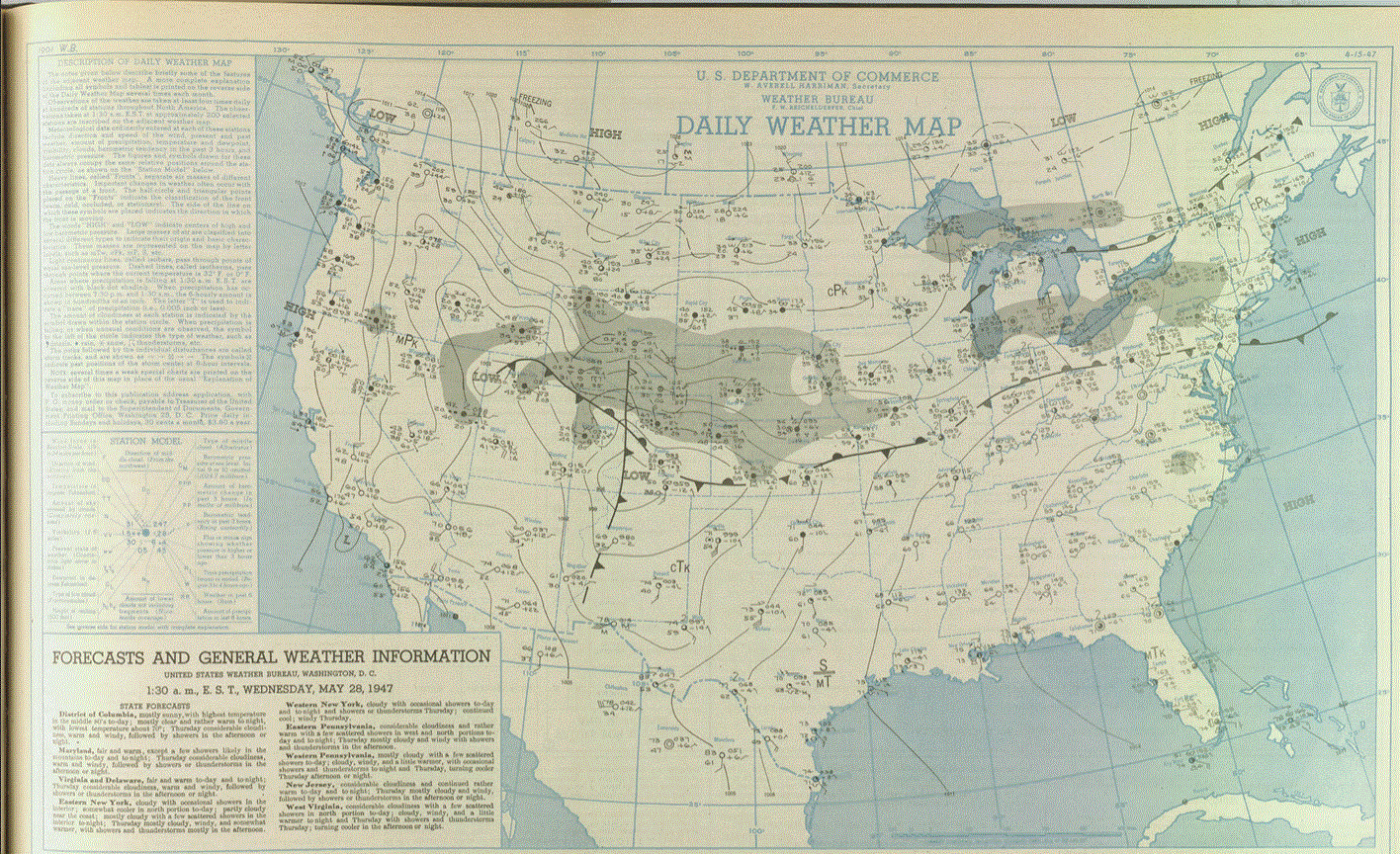
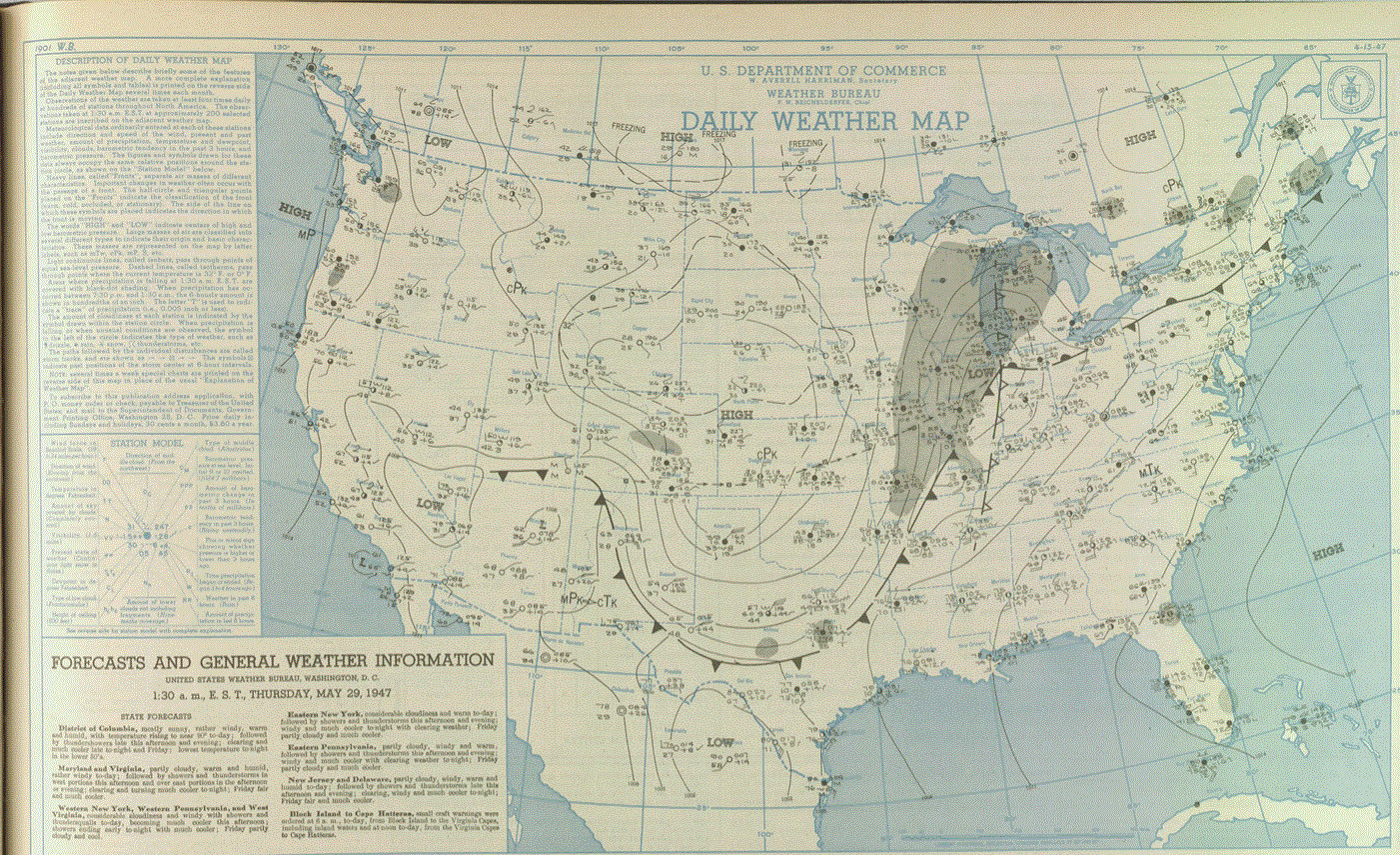
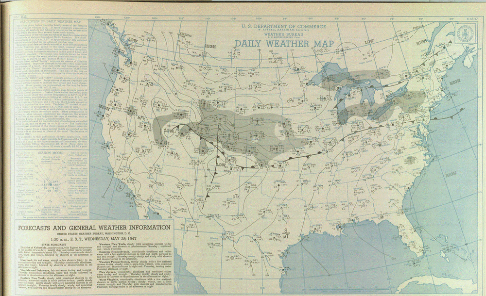
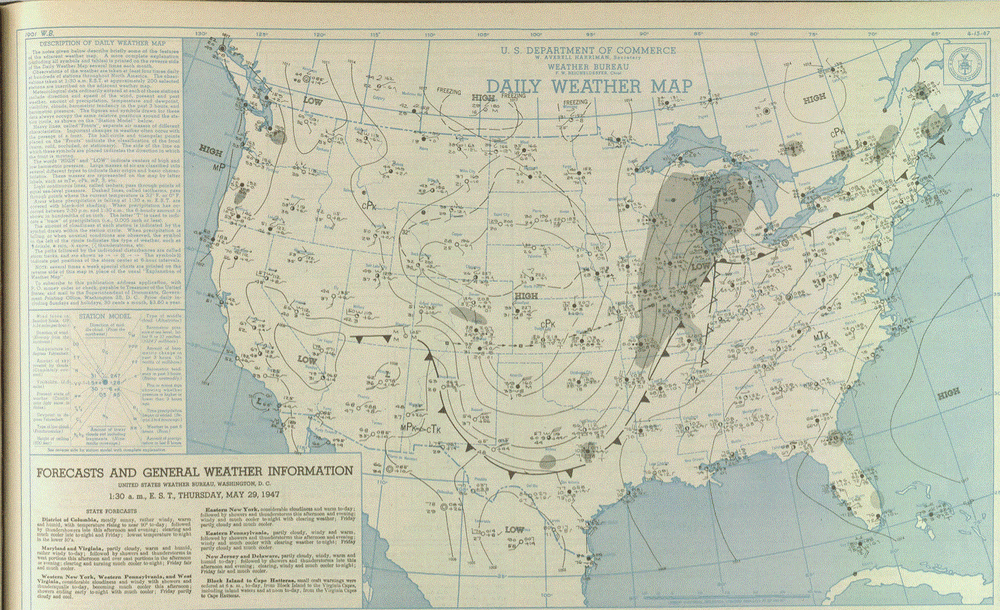
Here's the maps from May 28-29, 1947. CO low moved E along a boundary as HP from CAN pushed S into the Plains.
-
Really don't worry about frost in town now. Getting a couple flats of annuals delivered Monday. Plants won't do well until we get warmer nights in town. Then they take off. Inland areas still under a frost risk, tho. Many avid gardeners will use starter greenhouses, then plant sometime in early June. In the end, frost is always a risk up our way at any time during the summer away from the Lake. Just the way it is at higher lats.
-
Stiff Lake breeze today. Highs around 60 here in town expected. After the heat yesterday, this will feel chilly.
-
May 30 1998: A devastating line of storms hits east central Minnesota. 100 mph winds rip through Scott and Dakota County. Over 500 homes are damaged in Washington County. 15,000 trees are lost in the Twin Cities metro area, and 500,000 people lose power in Minneapolis. 1985: A tornado hits Lakefield, and the Twin Cities report 67 mph winds. For Saturday, May 30, 2026 1879 - A major outbreak of severe weather occurred in Kansas and western Missouri. In Kansas, tornadoes killed eighteen persons at Delphos, and thirty persons at Irving. Two tornadoes struck the town of Irving within a few minutes time virtually wiping the small Kansas community off the map. The second tornado was perhaps two miles wide, and exhibited multiple vortices. (David Ludlum) (The Weather Channel) 1948 - A railroad bed acting as a dam gave way during a flood along the Columbia River destroying the town of Vanport, OR. The nearly 19,000 residents escaped with little more than the clothes on their backs. (David Ludlum) 1948 - Twenty carloads of glass were needed in Denver, CO, to replace that destroyed by a severe hailstorm. (The Weather Channel) 1987 - Unseasonably warm weather prevailed across the eastern U.S. Eighteen cities, from Virginia to Ohio and Michigan, reported record high temperatures for the date. Afternoon highs of 97 degrees at Baltimore, MD, and Washington, DC, and 98 degrees at Newark, NJ, were records for the date. (The National Weather Summary) 1988 - Memorial Day heralded heavy snow in some of the mountains and higher passes of Wyoming, closing roads in Yellowstone Park. McDonald Pass, MT, was blanketed with eight inches of snow, while the temperature at Miles City, MT, soared to 94 degrees. A "supercell" thunderstorm in west Texas produced baseball size hail in Bailey and Lamb counties, and up to five inches of rain in less than an hour. (The National Weather Summary) (Storm Data) 1989 - Thunderstorms produced severe weather from the Upper Mississippi Valley to the Upper Ohio Valley during the day. A powerful (F-4) tornado injured three persons and caused a million dollars damage at New Providence, IA. Baseball size hail was reported at Blue Earth, MN. (The National Weather Summary) (Storm Data) 1990 - Thunderstorms developing along a warm front spawned fourteen tornadoes in northeastern Texas during the late afternoon and evening hours. The thunderstorms also produced baseball size hail near Marshall, wind gusts to 77 mph at Commerce, and up to five inches of rain. Thunderstorms over southwestern Kansas produced up to six inches of rain. (The National Weather Summary) (Storm Data)
-
Mid 80's here in town today. She was a warm one. Lake breeze kicked in around 6pm, and temps dropped like rock to the 50's in 20 mins. Felt good 2 gson's, 2 gnephew's, and 1 gneice graduated from THHS tonight. Grad parties start next weekend
-
May 29 1949: An intense downpour dumps over 7 inches of rain at Thief River Falls. 1947: Extremely late season snow falls in southern Minnesota, northern Iowa, and southern Wisconsin. Worthington, MN picks up an inch, while some places in southern Wisconsin receive up to 6 inches. For Friday, May 29, 2026 1951 - A massive hailstorm, from Wallace to Kearney County in Kansas, caused six million dollars damage to crops. (David Ludlum) 1953 - A tornado, 600 yards wide at times, killed two persons on its 20 mile path from southwest of Fort Rice ND into Emmons County. Nearly every building in Fort Rice was damaged. The Catholic church was leveled, with some pews jammed four feet into the ground. (The Weather Channel) 1987 - Thunderstorms in West Texas produced softball size hail at Lamesa, and hail up to twelve inches deep east of Dimmitt. Thunderstorms also spawned seven tornadoes in West Texas, including one which injured three persons at Wolfforth. Thunderstorms deluged the Texas Hill Country with up to eleven inches of rain. Severe flooding along the Medino, Hondo, Seco, Sabinal and Frio rivers caused more than fifty million dollars damage. (Storm Data) (The National Weather Summary) 1988 - A powerful cold front brought snow and high winds to parts of the western U.S. Austin, NV, was blanketed with ten inches of snow, and winds gusted to 75 mph at the Mojave Airport in California. Strong southerly winds and unseasonably warm weather prevailed in the north central U.S. Glasgow, MT, equaled their record for the month of May with a high of 102 degrees. (Storm Data) (The National Weather Summary) 1989 - Wintry weather gripped parts of the northwestern U.S. for the second day in a row. Great Falls, MT, was blanketed with 12 inches of snow, which pushed their total for the winter season to a record 117.4 inches. Six inches of snow whitened the Cascade Mountains of Oregon. (The National Weather Summary) (Storm Data) 1990 - Afternoon and evening thunderstorms produced severe weather from north central Colorado to the northern half of Texas. Severe thunderstorms spawned four tornadoes, and there were seventy reports of large hail or damaging winds. Midday thunderstorms produced wind gusts to 90 mph at Hobart, OK, and produced up to three and a half inches of rain in eastern Colorado in four hours. (The National Weather Summary) (Storm Data)
-
Yah know, warmer is suppose to be pretty normal now, right? So when it does get cooler, especially widespread, isn't that an oddity now? And are not oddities much more interesting? You would think the folks would be more impressed by those oddities than the normal stuff. What an odd bunch. I like wx, I enjoy it all! (Well almost all. Too hot/cold is bothersome).
-
That's a large field. I'd plant wild flowers/shrubs too, and keep part lawn. Women love manicured lawns with beautiful gardens in the mix. As a landscaper for a few years, they really love to go wild with plants at cabins. Did a lot of work at sites like that. But in town, it's a little different. That's my experience.