Brian D
-
Posts
3,023 -
Joined
-
Last visited
Content Type
Profiles
Blogs
Forums
American Weather
Media Demo
Store
Gallery
Everything posted by Brian D
-
July 5 1999: Flooding occurs over the Arrowhead. The largest 24-hour rainfall total is 8.84 inches in central St. Louis County. Note: Here in Two Harbors, flash flooding from 5+" of rain in a few short hrs overnight caused 7th Ave (Hwy 61) thru town to turn into a river as Skunk Creek overflowed it banks right where it crosses next to the railroad bridge. The 400 Blk of 6th Ave was submerged, as the creek passes thru there. Very low area there. Waters overwhelmed the large culvert under 4th St at the 6th Ave/4th St intersection. The school bus garage/old football field area was also overwhelmed with running water across the road. As the creek mouth is at Burlington Bay, the water went over the Burlington Bay Rd , and washed away the entire beach area. I was awakened around 3 am with lots of thunder, and my basement was starting to flood a little. So as I dealing with that. When I looked outside in the predawn light around 5 am, the waters coming down 7th Ave looked like a rapids. Large amounts of gravel/rocks/driftwood were strewn all over the road when the waters subsided. At the Knife River Bridges on the freeway, water was flowing right at the bottom of those, and down on the Scenic Hwy, water was flowing over the bridge there, trapping wood in its rails. Similar event happened again in the summer of 2012. For Sunday, July 5, 2026 1891 - Sixteen horses were killed by hail, and many more have to be put to death due to injuries from a hailstorm at Rapid City, SD. (The Weather Channel) 1900 - A spectacular three day fire began when a bolt of lightning struck a refinery in Bayonne NJ. (David Ludlum) 1916 - A hurricane produced 82 mph winds, an 11.6 foot tide, and a barometric pressure of 28.92 inches at Mobile, AL. (David Ludlum) 1937 - The temperature at Medicine Lake, MT, soared to 117 degrees to establish a state record. (Sandra and TI Richard Sanders - 1987) 1937 - Midale and Yellow Grass in Saskatchewan hit 113 degrees to establish an all-time record high for Canada that same day. (The Weather Channel) 1970 - The morning low at Death Valley CA was 103 degrees, and the high that afternoon was 120 degrees. (The Weather Channel) 1987 - Severe thunderstorms raked south central Kansas for the second morning in a row. Thunderstorm winds again gusted to 80 mph at Clearwater, and in the Wichita area reached 100 mph. Twenty-five persons were injured at a trailer park at El Dorado Lake. (The National Weather Summary) (Storm Data) 1988 - Afternoon and evening thunderstorms spawned eleven tornadoes in Montana and three in North Dakota. Baseball size hail was reported at Shonkin, MT, and wind gusts to 85 mph were reported south of Fordville, ND. Twenty cities in the north central U.S. reported record high temperatures for the date, including Fargo ND with a reading of 106 degrees. Muskegon, MI, equalled their July record with a high of 95 degrees. (The National Weather Summary) (Storm Data) 1989 - Moisture from what once was Tropical Storm Allison triggered thunderstorms over the Middle Atlantic Coast Region, which deluged Wilmington, DE, with a record 6.83 inches of rain in 24 hours, including 6.37 inches in just six hours. Up to ten inches of rain was reported at Claymont, northeast of Wilmington. July 1989 was thus the wettest month in seventy years for Wilmington, with a total of 12.63 inches of rain. Alamosa CO reported an all-time record high of 94 degrees, and Pierre, SD, hit 113 degrees. (The National Weather Summary) (Storm Data) Observances: 5 Sun National Bikini Day 5 Sun National Workaholics Day 5 Sun Pet Remembrance Day 5 Sun Mechanical Pencil Day 5 Sun National Apple Turnover Day 5 Sun National Graham Cracker Day 5 Sun National Hawaii Day 5 Sun National Outdoor Lights Day 5 Sun Work Without Your Hands Day
-
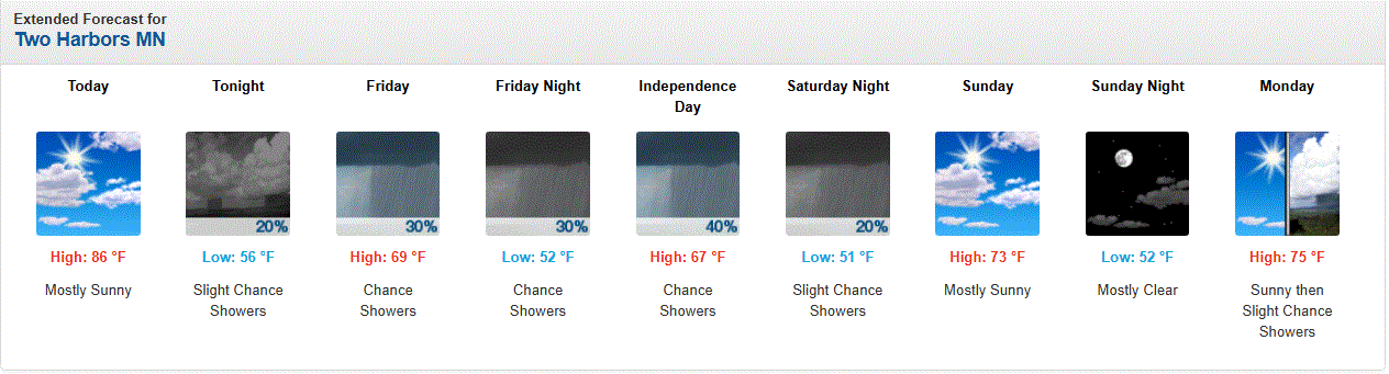
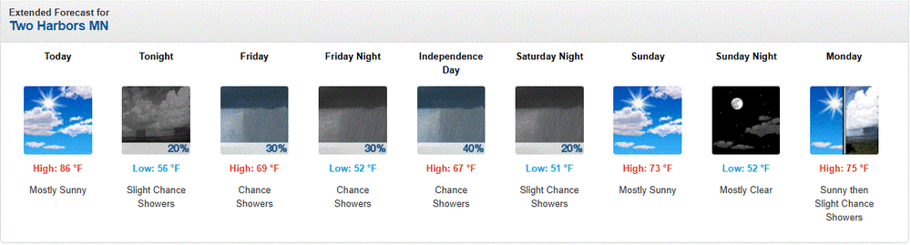
Pleasant day on tap with a Lake breeze again. Highs around 70.
-
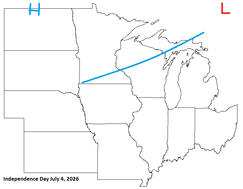
July 4 1999: Severe winds knock down millions of trees in the BWCA, injuring 19 people. Note: You can read about this event here: https://www.weather.gov/dlh/July_4_1999_BWCA_Storm 1962: An extremely heavy downpour falls at Jackson, dumping 7.5 inches of rain in two hours. For Saturday, July 4, 2026 1776 - Thomas Jefferson paid for his first thermometer, and signed the Declaration of Independence. According to his weather memorandum book, at 2 PM it was cloudy and 76 degrees. (David Ludlum) 1911 - The northeastern U.S. experienced sweltering 100 degree heat. The temperature soared to 105 degrees at Vernon, VT, and North Bridgton ME, and to 106 degrees at Nashua NH, to establish all-time records for those three states. Afternoon highs of 104 at Boston, MA, 104 at Albany, NY, and 103 at Portland, ME, were all-time records for those three cities. (The Weather Channel) 1956 - A world record for the most rain in one minute was set at Unionville, MD, with a downpour of 1.23 inches. (The Weather Channel) (The National Severe Storms Forecast Center) 1987 - Thunderstorms around the country provided extra fireworks for Independence Day. Thunderstorms produced wind gusts to 82 mph at Clearwater, KS, eight inches of rain in four hours at Menno SD, and three inches of rain in just fifteen minutes at Austin, KY. Morning thunderstorms drenched Oneonta AL with 8.6 inches of rain, their greatest 24 hour total in thirty years of records. The heavy rain caused mudslides and serious flooding, claiming two lives. (The National Weather Summary) (Storm Data) 1988 - Thunderstorms produced heavy rain over the Central Gulf Coast Region for the second day in a row. Monroe, LA, was deluged with 3.75 inches in two hours. Aberdeen and Rapid City, SD, reported record high temperatures for the date, with readings of 105 degrees. (The National Weather Summary) 1989 - Independence Day was hot as a firecracker across parts of the country. Nineteen cities, mostly in the north central U.S., reported record high temperatures for the date, including Williston ND with a reading of 107 degrees. In the southwestern U.S., highs of 93 at Alamosa, CO, 114 at Tucson, AZ, and 118 at Phoenix, AZ, equalled all-time records for those locations. (The National Weather Summary) Observances: (Note: Timely observance with sidewalk egg frying day for some out East.) 4 Sat National Sidewalk Egg Frying Day 4 Sat Independence Day 4 Sat International Day of Cooperatives 4 Sat Alice in Wonderland Day 4 Sat Filipino-American Friendship Day 4 Sat Fourth of July 4 Sat Independence From Meat Day 4 Sat Indivisible Day 4 Sat Jackfruit Day 4 Sat Invisible Day 4 Sat National Barbecued Spareribs Day 4 Sat National Grill Safety Day 4 Sat National Hillbilly Day 4 Sat Sidewalk Egg Frying Day 4 Sat National Caesar Salad Day
-
0.10" of rain from shwrs/stms that blossomed along the ridges, and moved overhead during the evening. Isolated chances today with a breezy Lake wind keeping temps rather cool. They shoot off the fireworks down at Agate Bay where the ore docks are, and those that watch them there will need a jacket/sweater/hoodie. I can see them from my home if I want to watch. Not really into the fireworks thing anymore.
-
Fog bank over the Lake with a chilly breeze across town. TBH, it has been a few yrs since I can remember so much fog, and chilly air at the 4th of July. Testament to the cooler, drier wx in May n June up here. June ended avg only because of hvy rains at the end of the month. It's those warmer rains that really help raise the water temp. It happens faster than just a warm Sun. Just like in winter, air temps alone don't just cool off the water, but the cold rain/snowfall mixing in the surface waters which includes LER/S precip.
-
Decent forecast. Most of the sub will be dodging shwrs/stms through the weekend. Enjoy your 4th festivities ev1

-
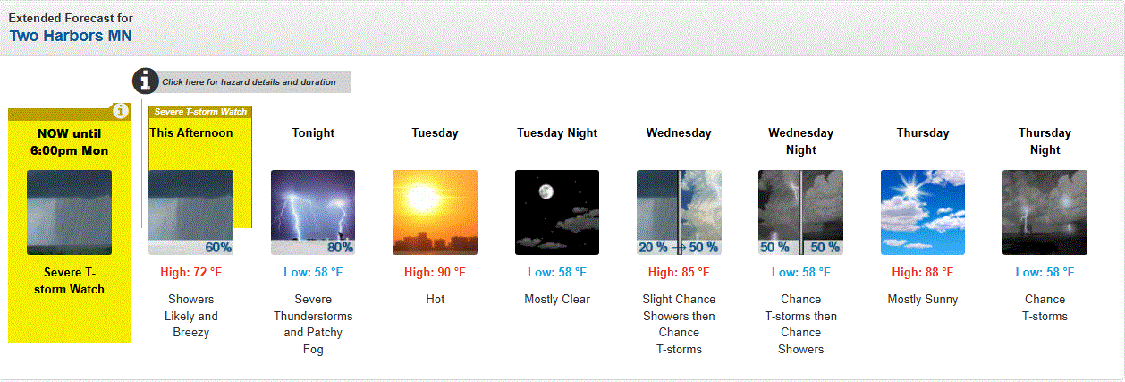
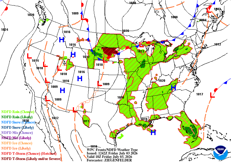
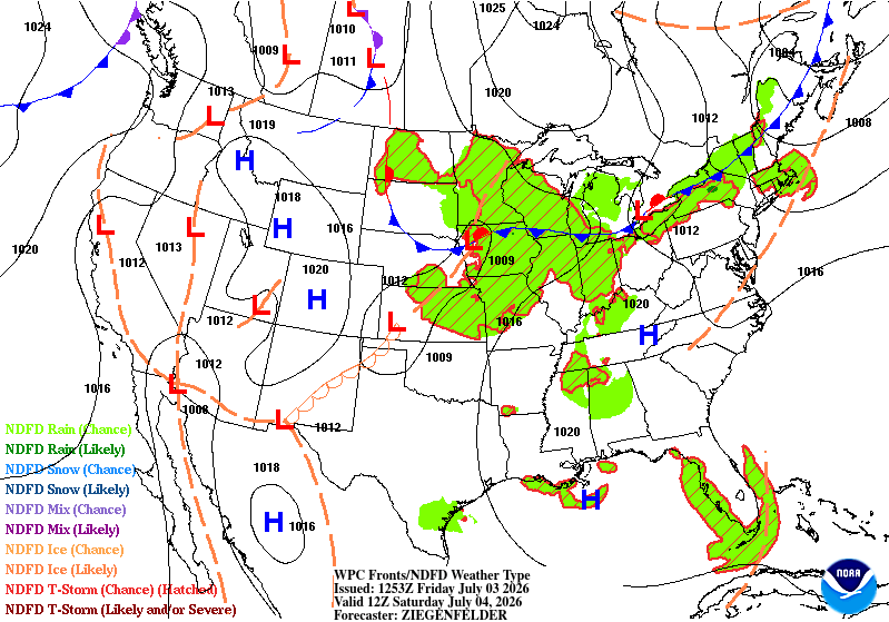
July 3 1947: Tornadoes hit Marshall and Polk Counties. For Friday, July 3, 2026 1966 - The northeastern U.S. was in the midst of a sweltering heat wave. The temperature at Philadelphia reached 104 degrees. Afternoon highs of 102 degrees at Hartford CT, 105 degrees at Allentown PA, and 107 degrees at LaGuardia Airport in New York City established all-time records for those two locations. (David Ludlum) (The Weather Channel) 1987 - Lightning struck and killed three men playing golf on a course near Kingsport TN. The three men had sought shelter from the rain under a tall tree on a small hill. Showers and thunderstorms produced heavy rain in New Jersey, with 5.2 inches reported at Trenton State College. (The National Weather Summary) 1988 - Thunderstorms around Fort Worth, TX, produced wind gusts to 76 mph at Burleson, along with two inches of rain in thirty minutes. The record low of 46 degrees at Youngstown OH was their sixth in a row. (The National Weather Summary)(Storm Data) 1989 - Showers and thunderstorms produced locally heavy rain in the eastern U.S. Bowling Green, KY, was soaked with 4.99 inches of rain during the morning hours, and up to ten inches of rain deluged Oconee County SC. The temperature at Alamosa, CO, soared to a record warm reading of 91 degrees, following a record low of 35 degrees the previous day. (The National Weather Summary) (Storm Data) Observances: 3 Fri National Stay Out of the Sun Day 3 Fri National Compliment Your Mirror Day 3 Fri St Thomas Day 3 Fri Air Conditioning Appreciation Day 3 Fri American Redneck Day 3 Fri Disobedience Day 3 Fri International Drop a Rock Day 3 Fri National Eat Your Beans Day 3 Fri National Fried Clam Day 3 Fri National Independent Beer Run Day 3 Fri StartTheConversation Day 3 Fri V.I. Emancipation Day 3 Fri International Plastic Bag Free Day 3 Fri National Chocolate Wafer Day
-
0.06" of rain yesterday as a stm passed by during the evening. Out of the 3 days of warmer wx, yesterday was the warmest with temps in the upper 80's n dews around 70 in town. Point did ok with that cast, but bombed the other 2 days. Looks like 70's with rain chances today thru the weekend.
-
July 2 1989: Softball sized hail falls near Dorset, and baseball sized hail is reported at Nevis in Hubbard County. 1972: A low of 32 is recorded at Big Falls in Koochiching County. For Thursday, July 2, 2026 1833 - An unusually large New England tornado, one half to three quarters of a mile wide, went from Salem Pond to Norton Pond, VT, and then into Canada. It prostrated nearly everything in its path. (The Weather Channel) 1843 - An alligator reportedly fell from the sky onto Anson Street in Charleston, SC, during a thunderstorm. (David Ludlum) 1987 - Thunderstorms in Colorado produced hail as large as golf balls northwest of Kiowa, which accumulated to a depth of twelve inches. Hail two and a half inches in diameter was reported at Black Forest. Hail damaged 900 acres of crops south of the town of Wiggins. (The National Weather Summary) (Storm Data) 1988 - Twenty-six cities in the eastern U.S. reported record low temperatures for the date. The morning low of 47 degrees at Roanoke, VA, broke the July record set the previous day. (The National Weather Summary) 1989 - Thunderstorms produced severe weather in the south central U.S., with 158 reports of large hail and damaging winds through the day. Evening thunderstorms in northeastern Texas produced softball size hail which caused more than five million dollars damage at Allen, and wind gusts to 90 mph at Dallas, which injured eight persons and caused seven million dollars damage. Winnfield LA reported 29.52 inches of rain in six days, for a total of 62.50 inches for the first six months of the year. Midland, TX, reported an all-time record high of 112 degrees. (Storm Data) (The National Weather Summary) Observances: 2 Thu National Wildland Firefighter Day 2 Thu I Forgot Day 2 Thu Civil Rights Act 2 Thu Made In The USA Day 2 Thu National Anisette Day 2 Thu National Disco Day 2 Thu National Lint Awareness Day 2 Thu National Report Military Fraud Day 2 Thu Special Recreation for the Disabled Day 2 Thu World Sports Journalists Day 2 Thu Freedom From Fear of Speaking Day 2 Thu World UFO Day
-
They could really use a strong monsoon flow through the 4 corners area this year. Impressive local wx tho.
-
One more warmer day then back to reality along the shore.
-
FAIL! Overcooked highs.
-
Clouds broke, and lots of aftrn sun. Temps around 80 with mid 60 dews. Pleasantly warm.
-
And yet that clarity is bad. Mussels cleaning the waters of phytoplankton is harming the fish pops. The little ones depend on the plankton to survive. Just watched a YT vid on this issue. Sad story.
-
Temps in the 70's right now in town under cloudy skies. Scattered showers in the area. Winds switched to the SW yesterday evening, and are the same today. When the sun peeks out, she'll get warm again.
-
July 1 1964: Tyler picks up over 6 inches of rain in 24 hours. For Wednesday, July 1, 2026 1792 - A tornado or hurricane hit Philadelphia and New York City. Many young people were drowned while out boating on that Sunday. (David Ludlum) 1911 - The high of just 79 degrees at Phoenix AZ was their coolest daily maximum of record for the month of July. The normal daily high for July 1st is 105 degrees. (The Weather Channel) 1979 - It snowed almost half a foot at Stampede Pass WA, a July record. (The Weather Channel) 1987 - Lake Charles LA was drenched with a month's worth of rain during the early morning. More than five inches of rain soaked the city, including 2.68 inches in one hour. A thunderstorm in the southern Yakima Valley of Washington State produced high winds which downed trees up to six feet in diameter. (Storm Data) (The National Weather Summary) 1988 - Twenty-six cities in the north central and northeastern U.S. reported record low temperatures for the date. Lows of 48 degrees at Providence RI, 48 degrees at Roanoke VA, 49 degrees at Stratford CT, and 48 degrees at Wilmington, DE, were records for the month of July. Boston MA equalled their record for July with a low of 50 degrees. Five inches of snow whitened Mount Washington NH. (The National Weather Summary) 1989 - Showers and thunderstorms associated with the low pressure system which was once Tropical Storm Allison continued to drench parts of Mississippi, Louisiana and eastern Texas. Late night thunderstorms produced 12.58 inches of rain at Biloxi, MS, in six hours, and 10.73 inches at Gulfport MS. Flooding in Mississippi over the first six days of the month caused 55 million dollars damage. (The National Weather Summary) (Storm Data) Observances: 1 Wed National Postal Worker Day 1 Wed World Bronchiectasis Day 1 Wed International Joke Day 1 Wed Canada Day 1 Wed Disability Pride Month 1 Wed Bobby Bonilla Day 1 Wed Battle of Gettysburg 1 Wed American Zoo Day 1 Wed Blink 182 Day 1 Wed Dog House Repair Month 1 Wed Early Bird Day 1 Wed International Chicken Wing Day 1 Wed International Reggae Day 1 Wed National Baby-Led Weaning Day 1 Wed National Creative Ice Cream Flavors Day 1 Wed National Financial Freedom Day 1 Wed National Gingersnap Day 1 Wed National Patio Day 1 Wed National Television Heritage Day 1 Wed National U.S. Postage Stamp Day 1 Wed Second Second Half of the Year Day 1 Wed Smart Irrigation Month 1 Wed ZIP Code Day
-
When stms are over the Lake, many times I get a blast of fog from the strong outflow. Lake Superior water temps are well below normal right now. Warm, humid air creates a lot of fog in Spring/early Summer.
-
Two Harbors' mean 53.9 (avg 56.3) is the 11th coldest temp, tied with 2019, out of 65 unique temps (midpoint temp is 56.6) in the record since 1894. 4.63" of precip (avg 4.23"). DLH mean 60.7 (avg 61.2) is 26th warmest out of 79 unique temps (midpoint temp is 59.0) since 1874. 4.28" of precip (avg 4.39). I looked at a PWS stn that is near the old wx bureau office location in the downtown area. It had an avg of 59.6. Duluth arpt data in the Threadex record starts in 1941. Near lake, and over the hill data can be a little different with the diurnal range.
-
Wind switched, and temps have risen into the 80's here in town in the last couple hrs.
-
Checked lake temps around Two Harbors today. A whopping 39F/4C. Chilly out there still.
-
The lake is keeping temps subdued. Only in the 60's along the shore. 80's inland. Natural A/C working well.
-
June 30 1982: Frost hits St. Louis County. Kulger Township falls to 27 degrees and Meadowlands bottoms out at 32. 1871: Extremely large hail falls in Meeker County. Some of the stones are 6 inches in circumference, breaking many windows on the north sides of houses. For Tuesday, June 30, 2026 1886 - The second destructive hurricane in nine days hit the Apalachicola-Tallahassee area. (David Ludlum) 1942 - The temperature at Portland, OR, hit 102 degrees, an all-time record for that location. (The Weather Channel) 1972 - The entire state of Pennsylvania was declared a disaster area as a result of the catastrophic flooding caused by Hurricane Agnes, which claimed 48 lives, and caused 2.1 billion dollars damage. (The Weather Channel) 1987 - Hot weather prevailed in the Pacific Northwest, with readings above 100 degrees reported as far north as southern British Columbia. Yakima, WA, reported a record high of 100 degrees, while temperatures near the Washington coast hovered near 60 degrees all day. Thunderstorms prevailed from southwest Texas to New England. Thunderstorm winds gusting to 100 mph at Gettysburg, PA, killed one person. High winds and large hail caused more than five million dollars damage to property and crops in Lancaster County, PA. (The National Weather Summary) (Storm Data) 1988 - Thunderstorms in eastern Kansas drenched Worden with 12.21 inches of rain, and a wall of water two to four feet deep swept through Lone Star, KS, flooding every home in the town. Up to ten inches of rain was reported southeast of Callaway, NE. Thunderstorm winds gusted to 75 mph at Winfield, KS. Seventeen cities in the north central and northeastern U.S. reported record low temperatures for the date, including Duluth, MN, with a reading of 36 degrees. (The National Weather Summary) (Storm Data) 1989 - Winnfield, LA, reported 22.52 inches of rain in three days, and more than thirty inches for the month, a record for June. Shreveport LA received a record 17.11 inches in June, with a total for the first six months of the year of 45.55 inches. Thunderstorms also helped produce record rainfall totals for the month of June of 13.12 inches at Birmingham AL, 14.66 inches at Oklahoma City, OK, 17.41 inches at Tallahassee FL, 9.97 inches at Lynchburg, VA, and more than 10.25 inches at Pittsburgh, PA. Pittsburgh had also experienced a record wet month of May. (The National Weather Summary) Observances: 30 Tue World Social Media Day 30 Tue International Asteroid Day 30 Tue National Meteor Watch Day 30 Tue International Day of Parliamentarism 30 Tue National Corvette Day 30 Tue Social Media Day 30 Tue National OOTD Day 30 Tue Clean Your Disposal Day
-
Temps inland already in the 70's. Cooler here in town with 50's, but the cloud deck just cleared, so temps should start rising quickly. We'll see if point cast of 90 here in town pans.
-
3+" of rain around the Two Harbors area yesterday. A general 2-4" in the wider area. More chances for stms mainly Wed then Fri into the weekend.
-
With more heavy rain moving through the area tonight, it's going to be soaked ground with high heat tomorrow. I'm not buying 58 now. Probably 60's. Still not as bad as down there, but I don't have A/C either. Just a fan. Going to be toughing it out like usual.