Brian D
-
Posts
3,099 -
Joined
-
Last visited
Content Type
Profiles
Blogs
Forums
American Weather
Media Demo
Store
Gallery
Everything posted by Brian D
-
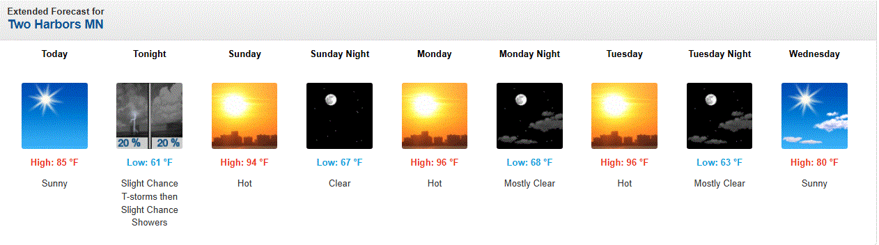
Temps peaking right now at 92/71/98. General low/mid 90's around here with 80's along the shoreline. Still only 79 in the house, so doing good. Will open the windows later after sunset.
-
Currently 78 in town (even on the shoreline), 80 at the TH arprt @ 9:30 am. And so it begins. Lets see if we can hit 100 in the area. WX wise that'd be awesome. Practically, ISH!
-
July 12 1863: Unseasonably cool temperatures are felt across the state. Frost is reported in the Twin Cities area. For Sunday, July 12, 2026 1951 - The Kaw River flood occurred. The month of June that year was the wettest of record for the state of Kansas, and during the four days preceding the flood much of eastern Kansas and western Missouri received more than ten inches of rain. Flooding in the Midwest claimed 41 lives, left 200 thousand persons homeless, and caused a billion dollars property damage. Kansas City was hardest hit. The central industrial district sustained 870 million dollars property damage. (The Kansas City Weather Alamnac) 1980 - Lightning struck a large broiler house in Branford, FL, and the ensuing fire broiled 11,000 nearly ready broilers. Firemen were able to save a few thousand chickens, however. (The Weather Channel) 1987 - Cool air invaded the High Plains Region. Eight cities reported record low temperatures for the date, including Sheridan, WY, with a reading of 37 degrees. Thunderstorms developing along the cold front in the central U.S. produced 6.5 inches of rain at Fort Dodge, IA, and 2.5 inches in one hour at St. Joseph MO. (The National Weather Summary) 1988 - Evening thunderstorms produced severe weather over the Dakotas, including baseball size hail at Aberdeen, SD, and softball size hail near Fullerton, ND. Thunderstorms produced heavy rain in Arkansas and northeastern Texas, with 6.59 inches reported at Mesquite, TX, in just an hour and fifteen minutes. Garland, TX, reported water up to the tops of cars following a torrential downpour. (The National Weather Summary) (Storm Data) 1989 - Early morning thunderstorms over eastern Kansas deluged McFarland with more than six inches of rain. Afternoon thunderstorms in Wyoming produced up to eighteen inches of dime size hail near Rock Springs, along with torrential rains, and a three foot high wall of mud and water swept into the town causing more than 1.5 million dollars damage. Evening thunderstorms produced severe weather in Oklahoma and Arkansas, deluging Dardanelle, AR, with 3.50 inches of rain in less than twenty minutes. About seventy cows were killed when lightning struck a tree in Jones County, TX. (The National Weather Summary) (Storm Data) Observances: 12 Sun National Simplicity Day 12 Sun Malala Day 12 Sun Orangemen's Day (The Twelfth) 12 Sun Etch A Sketch Day 12 Sun National Different Colored Eyes Day 12 Sun National Eat Your Jello Day 12 Sun National Hair Creator’s Day 12 Sun National Pecan Pie Day 12 Sun National Tile Repair Day 12 Sun New Conversations Day 12 Sun Night of Nights 12 Sun Paper Bag Day
-
97, 98, 95 today, tomorrow, and Tues. 75 in the house atm. Looks like WSW light wind the coming days, so that should keep the shoreline pretty warm, too.
-
Yeah, I get it. I keep the windows closed during the day, open at night. It's not terrible. If I can't stand this, this year, then that will happen. At some point tough isn't enough. Will use wet towels with a fan blowing, if I really need too. After this tho, 70 will be frosty LOL
-
Around 80 on the shoreline to upper 80's inland today. Dews upper 60's to low 70's. Mid 80's imby. Tomorrow starts the really hot stuff. We'll see how much.
-
No. Just fans. It never stays hot long enough to really need it.
-
July 11 1903: The temperature plummets down to 26 at Leech Lake Dam. For Saturday, July 11, 2026 1888 - Heavy snow reached almost to the base of Mt. Washington, NH, and the peaks of the Green Mountains were whitened. (David Ludlum) 1987 - Early morning thunderstorms produced wind gusts to 90 mph at Parkston, SD, and wind gusts to 87 mph at Buffalo, MN. Later in the day strong thunderstorm winds at Howard WI collapsed a circus tent injuring 44 persons. (The National Weather Summary) (Storm Data) 1988 - Thunderstorms produced heavy rain in southern Texas, with totals ranging up to 13 inches near Medina. Two men drowned when their pick-up truck was swept into the Guadalupe River, west of the town of Hunt. Ten cities in the eastern U.S. reported record high temperatures for the date. Baltimore, MD, reported a record high reading of 102 degrees for the second day in a row. (Storm Data) (The National Weather Summary) 1989 - Afternoon and evening thunderstorms produced severe weather from North Dakota to Indiana. Thunderstorms in North Dakota produced tennis ball size hail at Carson. Thunderstorms in Indiana produced wind gusts to 75 mph at Fort Wayne. Five cities in the Southern Atlantic Coast Region reported record high temperatures for the date, including Lakeland, FL, with a reading of 100 degrees. (The National Weather Summary) (Storm Data) Observances: 11 Sat World Population Day 11 Sat World Essential Oils Day 11 Sat All American Pet Photo Day 11 Sat Cheer Up the Lonely Day 11 Sat International Essential Oils Day 11 Sat National 7-Eleven Day 11 Sat National Blueberry Muffin Day 11 Sat National Culture and Senior Citizens Day 11 Sat National Mojito Day 11 Sat National Rainier Cherry Day 11 Sat National Polyphenol Day 11 Sat National State Fair Food Day 11 Sat National Swimming Pool Day 11 Sat World Benzodiazepine Awareness Day 11 Sat Free Slurpee Day
-
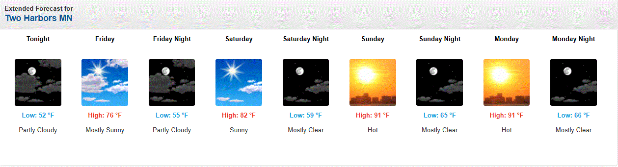
Heritage Days in Two Harbors started Thurs. Parade today will be starting soon. Right now temps in the upper 70's with a 65 dew. Mid 80's forecast for mid aftrn.
-
They upped the temps the next few days from around 90 to mid 90's here in town. SW winds will bring hot air, along with some down sloping effect from the ridges. We'll see how this pans, but it'll be nasty without A/C.

-
July 10 2002: Intense rainfall causes extensive street flooding in St. Cloud. 2.70 inches of rain falls in 1 hour and 45 minutes at St. Cloud State University. People were stranded in their cars and had to be rescued by the fire department. For Friday, July 10, 2026 1913 - The mercury hit 134 degrees at Greenland Ranch in Death Valley, CA, the hottest reading of record for the North American continent. Sandstorm conditions accompanied the heat. The high the previous day was 129 degrees, following a morning low of 93 degrees. (David Ludlum) (The Weather Channel) 1926 - A lightning bolt struck an ammunition magazine in northern New Jersey, and a big red ball of fire leaped into the air triggering a series of explosions. All buildings within a half mile radius were destroyed, and debris fell as far as twenty-two miles away. Sixteen persons were killed, and property damage was seventy million dollars. (David Ludlum) 1936 - Afternoon highs of 112 degrees at Martinsburg, WV, 109 degrees at Cumberland, MD, and Frederick, MD, 110 degrees at Runyon, NJ, and 111 degrees at Phoenixville, PA, established all-time record highs for those four states. It was the hottest day of record for the Middle Atlantic Coast Region. (The Weather Channel) 1979 - The temperature at El Paso, TX, hit 112 degrees, an all-time record for that location. The next day was 110 degrees. (The Weather Channel) 1980 - The temperature in downtown Kansas City, MO, hit 109 degrees, following a sultry overnight low of 89 degrees. The daily low of 89 degrees was the warmest of record for Kansas City, and overall it was the hottest July day of record. It was the seventh of a record seventeen consecutive days of 100 degree heat, and the mean temperature for the month of 90.2 degrees was also an all-time record for Kansas City. 1987 - An early morning thunderstorm in Minnesota produced wind gusts to 91 mph at Waseca. Later that day, thunderstorms in South Dakota produced wind gusts to 81 mph at Ipswitch, and baseball size hail near Hayes and Capa. (The National Weather Summary) (Storm Data) 1988 - Thunderstorms brought welcome rains to parts of the central U.S., but produced severe weather along the New England coast, in the Great Lakes Region, in North Carolina, and in the Southern Plateau Region. Strong thunderstorm winds gusting to 80 mph at Bullfrog, UT, sank three boats on Lake Powell. (Storm Data) (The National Weather Summary) 1989 - Severe thunderstorms spawned seventeen tornadoes in the northeastern U.S. A powerful (F-4) tornado struck Hamden CT and New Haven, CT, causing 100 million dollars damage at Hamden, and another 20 million dollars damage around New Haven. Forty persons were injured in the tornado. Seventy persons were injured in a tornado which traveled from Watertown, CT, to Waterbury, CT, and another powerful (F-4) tornado touched down near Ames NY injuring twenty persons along its 43.5 mile track. It was the strongest tornado of record for eastern New York State. (Storm Data) (The National Weather Summary) 2005 - Hurricane Dennis landed near Pensacola, Florida as a category 3 storm. Maximum sustained winds at the time of landfall were near 120 mph. There were nine hurricane-related fatalities in the U.S. and preliminary estimates of insured losses ranged from $1 to $1.5 billion. Observances: 10 Fri National Kitten Day 10 Fri National Piña Colada Day 10 Fri National Pet Bedding Hygiene Awareness Day 10 Fri National Wyoming Day 10 Fri Pick Blueberries Day 10 Fri Political Flag Day 10 Fri Transplant Financial Coordinator Day 10 Fri Global Energy Independence Day
-
Looks like possible hot wx starting this weekend. Winds are forecast to be SW, and if so, then it will get rather warm, even here imby. Shoreline will stay a little cooler unless the wind is WSW. SW winds along the shoreline clip the Lake, but a slight W direction keeps it a fully land breeze. Down sloping may jump temps even higher than forecast.
-
Beautiful day with highs peaking now in the upper 70's/low 80's across the area.
-
July 9 1932: A tornado touches down near Springfield and moves into St. James, causing 500 thousand dollars in damage. For Thursday, July 9, 2026 1860 - A hot blast of air in the middle of a sweltering summer pushed the mercury up to 115 degrees at Fort Scott and Lawrence, KS. (David Ludlum) 1882 - Ice formed on the streets of Cheyenne, WY, during a rare summer freeze. (David Ludlum) 1936 - The temperature hit an all-time record high of 106 degrees at the Central Park Observatory in New York City, a record which lasted until LaGuardia Airport hit 107 degrees on July 3rd in 1966. (The Weather Channel) 1968 - Columbus, MS received 15.68 inches of rain in 24 hours to establish a record for the state. (The Weather Channel) 1987 - Thunderstorms produced severe weather in Michigan. A tornado near Munising, MI, destroyed part of a commercial dog kennel, and one of the missing dogs was later found unharmed in a tree top half a mile away. (The National Weather Summary) (Storm Data) 1988 - Twenty-three cities in the eastern U.S. reported record high temperatures for the date. Alpena, MI, and Buffalo, NY, suffered through their sixth straight day of record heat. The percentage of total area in the country in the grips of severe to extreme drought reached 43 percent, the fourth highest total of record. The record of 61 percent occurred during the summer of 1934. (The National Weather Summary) 1989 - Morning thunderstorms produced very heavy rain in southern Lower Michigan and northern Indiana. Up to 5.6 inches of rain was reported in Berrien County, MI. Sioux Falls SD reported a record high of 108 degrees. (The National Weather Summary) (Storm Data) Observances: 9 Fri Law Enforcement Appreciation Day 9 Fri Balloon Ascension Day 9 Fri International Choreographers Day 9 Fri National Apricot Day 9 Fri National Austin Day 9 Fri National Carter Day 9 Fri National Faith Day 9 Fri National Law Enforcement Day 9 Fri National WONK Day 9 Fri National Word Nerd Day 9 Fri Play God Day 9 Fri Static Electricity Day
-
Shallow 5km, so yes, some movement could be felt. A quick rattling of stuff in the house more likely.
-
July 8 2002: A three-day deluge ends in central Minnesota with 10 inches in northern Kanabec county and 9.5 inches in southwest Aitkin County. 1974: Minnesota experiences an intense heat wave, with the Twin Cities reaching 101, the warmest temperature in 26 years. For Wednesday, July 8, 2026 1816 - Frost was reported in low places throughout New England. (David Ludlum) 1950 - The town of York, NE, was deluged with 13.15 inches of rain in 24 hours to establish a state record. (The Weather Channel) 1975 - Three people were killed and six others were injured when lightning struck a walnut tree near Mayo, FL. The nine people were stringing tobacco under a tin shed when the bolt hit the nearby tree. (The Weather Channel) 1987 - Thunderstorms in the central U.S. produced wind gusts to 90 mph at Waterloo, IA, 6.38 inches of rain at Tescott, KS, and twenty-five minutes of ping-pong ball size hail at Drummond, OK. (The National Weather Summary) (Storm Data) 1988 - Thirty cities in the north central and northeastern U.S. reported record high temperatures for the date. Beckley, WV, equalled their all-time record with a high of 93 degrees. Afternoon and evening thunderstorms spawned seven tornadoes in Adams and Logan counties of eastern Colorado, and hail caused 2.3 million dollars damage in Adams, Logan and Washington counties. (The National Weather Summary) (Storm Data) 1989 - Sixteen cities in the central and western U.S. reported record high temperatures for the date. The high of 103 degrees at Denver, CO, equalled their record for July, and a 110 degree reading at Rapid City, SD, equalled their all-time record high. Denver reported a record five straight days of 100 degree heat, and Scottsbluff, NE, reported a record eight days in a row of 100 degree weather. (The National Weather Summary) Observances: 8 Wed National Love Your Skin Day 8 Wed National Raspberry Day 8 Wed National Video Game Day 8 Wed Be a Kid Again Day 8 Wed Math 2.0 Day 8 Wed National Blueberry Day 8 Wed National Freezer Pop Day 8 Wed National Ice Cream Sundae Day 8 Wed Oneofusismissing Day 8 Wed SCUD Day 8 Wed National Chocolate with Almonds Day
-
Dear God, that guy nearly got creamed. Very close call.
-
0.12" of rain last night. Cooler day on tap today with a high around 70.
-
Nice batch of rain moving in for the night. Hope another 1-2" falls across the Northland. Many still need it.
-
Nice n warm aftrn. 80 with 69 dew. Last night's rain helped with that.
-
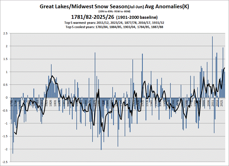
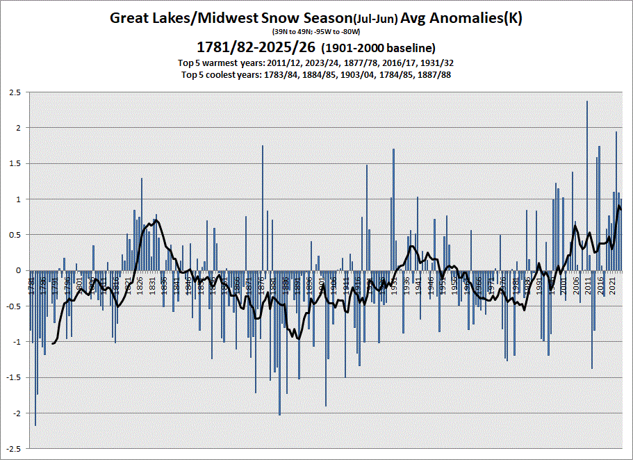
Snow season 25/26 showing another very warm year. 5 & 10 year trend charts shown respectively.
-
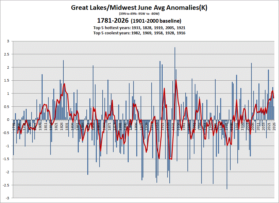
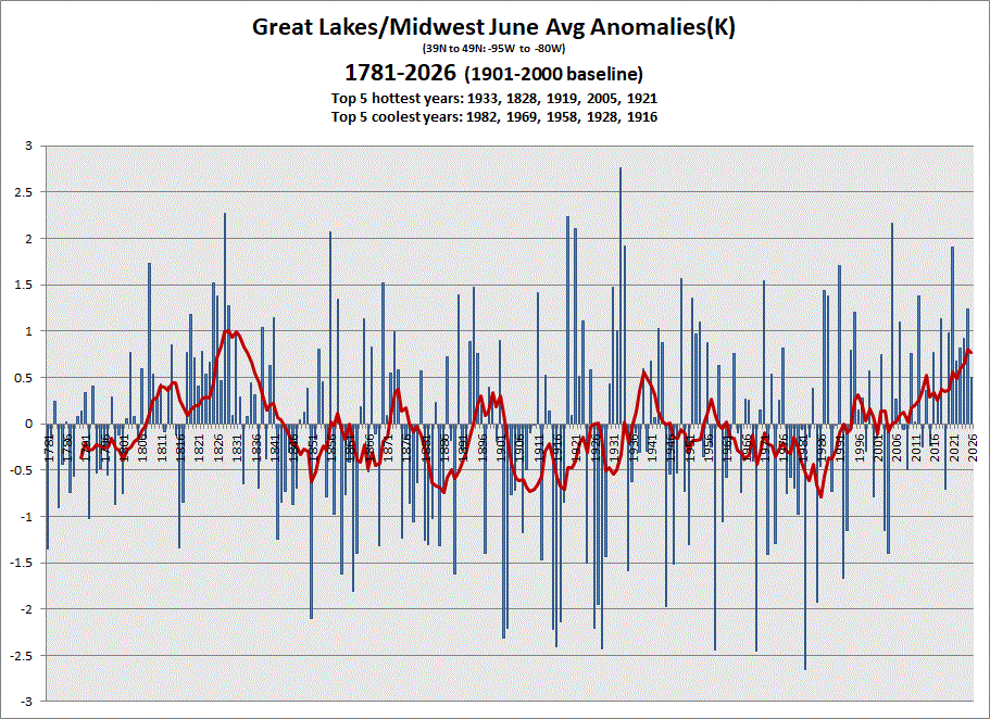
Early data in for June, and we ended near avg on the + side. 5 & 10 yr trend charts shown respectively.
-
July 7 2000: Torrential rains douse the southern Twin Cities metro area with 8 inches in a three to five hour span in northern Dakota county. Eagan receives the most damage; many homes were flooded. 1955: A tornado hits Marshall, leaving one dead and 13 injured. Hail causes one million dollars in damage. For Tuesday, July 7, 2026 1905 - The mercury soared to 127 degrees at Parker, AZ, to tie the state record established at Fort Mohave on the 15th of June in 1896. (The Weather Channel) 1915 - A severe wind and thunderstorm caused heavy damage and 38 deaths in and near Cincinnati, OH. Many older buildings were demolished. The steamship Dick Fulton was overturned. (The Weather Channel) 1981 - Montana was in the midst of a snowstorm that dumped ten inches at Glacier National Park, and produced winds to 90 mph. Meanwhile, Denver, CO, set a record high with a reading of 101 degrees. (The Weather Channel) 1987 - Thunderstorms spawned eight tornadoes in Colorado, and three in West Texas. Thunderstorms also produced softball size hail at Bula, TX. In the midst of a record thirty-nine day string of 100 degree days, the temperature at Tucson, AZ, dipped to 66 degrees, marking their third straight record low for the date. (The National Weather Summary) (Storm Data) 1988 - Thirty-eight cities in the north central and northeastern U.S. reported record low temperatures for the date. Youngstown, OH, hit 100 degrees, and for the second day in a row, Flint, MI, reached 101 degrees, equalling all-time records for those two cities. (The National Weather Summary) 1989 - Thunderstorms produced severe weather during the day, with more than 100 reports of large hail and damaging winds from Ohio to Massachusetts and New Hampshire. Thunderstorm winds reached 90 mph in Sullivan County, NH, and golf ball size hail was reported in Pennsylvania. Twenty-four cities, mostly in the southwestern U.S., reported record high temperatures for the date. Afternoon highs of 105 degrees at Cedar City, UT, and 114 degrees at Moab, UT, were all-time records for those locations. (Storm Data) (The National Weather Summary) Observances: 7 Tue World Chocolate Day 7 Tue Global Forgiveness Day 7 Tue International Peace & Love Day 7 Tue National Deck Day 7 Tue National Dive Bar Day 7 Tue National Dora Day 7 Tue National Day of Rock ‘n’ Roll 7 Tue National Father Daughter Take a Walk Day 7 Tue National Koi Day 7 Tue National Macaroni Day 7 Tue National Strawberry Sundae Day 7 Tue Tell the Truth Day
-
1.20" of rain with some lightning n thunder for effect last night. A good soaker. Highs around 80 today. That'll feel nice.
-
Another nice day on tap with temps in the 70's. Lake breeze more E today will be less chilly than NE breezes.