Brian D
-
Posts
3,107 -
Joined
-
Last visited
Content Type
Profiles
Blogs
Forums
American Weather
Media Demo
Store
Gallery
Everything posted by Brian D
-
Cloudy most of yesterday with highs in the 60's. 40's this morning. Might hit 70 today if the sun stays out. Red Flag warning out as well.
-
As I mentioned when I started this thread, we will see this off n on throughout the summer.
-
June 13 1991: One fatality and 5 injuries occur when lightning strikes a tree at Hazeltine Golf Course during the US Open. 1930: A tornado hits the Northfield area, and causes heavy damage at Randolph. For Saturday, June 13, 2026 1889 - Forest fires in northern Wisconsin and northeast Minnesota were in the process of destroying millions of dollars of board feet of timber. (David Ludlum) 1907 - The temperature at Tamarack, CA, dipped to 2 degrees above zero, the lowest reading of record for June for the U.S. The high that day was 30 degrees. Tamarack received 42 inches of snow between the 10th and the 13th. On the 13th the snow depth was 130 inches. (The Weather Channel) 1984 - Severe thunderstorms struck Denver deluging the city with five inches of rain, and leaving up to six feet of water in some places. Softball size hail smashed windshields and ripped through metal cars. Snow plows had to be called out. (The Weather Channel) 1987 - Fifteen cities in the north central U.S. reported record high temperatures for the date, including International Falls, MN, with a reading of 92 degrees. Mason City IA and Waterloo IA reported record highs of 100 degrees. Thunderstorms in the northeastern U.S. produced golf ball size hail around Hamilton Square NJ, along with high winds which tore the roof off a hospital causing a million dollars damage. Averill Park NY was deluged with 1.64 inches of rain in fifteen minutes. (Storm Data) (The National Weather Summary) 1988 - Afternoon thunderstorms produced severe weather in the Southern and Central Plains Region. Forrest NM was deluged with 5.5 inches of rain in ninety minutes. Temperatures soared into the 90s across much of the eastern half of the nation, including New England. Northern Illinois reported a record twenty straight days of dry weather. (The National Weather Summary) 1989 - Thunderstorms produced severe weather from the Southern Plains Region to the Carolinas during the day and night, and continued to drench parts of Texas and Oklahoma with heavy rain. Oklahoma City reported 13.41 inches of rain for the first thirteen days of the month, and Fort Worth TX reported 29.56 inches for the year, a total more than 13 inches above normal. Severe drought continued to rage across South Texas. (The National Weather Summary) Observances: 13 Sat Global Wellness Day 13 Sat National Sewing Machine Day 13 Sat World Softball Day 13 Sat International Albinism Awareness Day 13 Sat National Weed Your Garden Day 13 Sat Feast of St. Anthony 13 Sat International Axe Throwing Day 13 Sat National Chamoy Day 13 Sat National Dance/Movement Therapy Advocacy Day 13 Sat National Jane Day 13 Sat National Kitchen Klutzes of America Day 13 Sat National Productive Business Civility Day 13 Sat Random Acts of Light Day
-
June 12 1917: The ice pack finally breaks up on Lake Superior near Duluth, one of the latest ever 'ice out' dates on record. For Friday, June 12, 2026 1881 - Severe thunderstorms spawned more than half a dozen tornadoes in the Lower Missouri Valley. Five of the tornadoes touched down near Saint Joseph MO. In south central Kansas a tornado nearly wiped out the town of Floral. Hail and high winds struck Iowa and southern Minnesota. In Minnesota, Blue Earth City reported five inches of rain in one hour. (David Ludlum) 1947 - A heavy wet snow blanketed much of southern and central Wyoming, and gave many places their heaviest and latest snow of record. Totals included 18.4 inches at Lander, 8.7 inches at Cheyenne, and 4.5 inches at Casper. (11th-12th) (The Weather Channel) 1969 - Record late season snows covered parts of Montana. Five inches was reported at Great Falls and east of Broadus. Billings, MT, tied their June record with lows of 32 degrees on the 12th and the 13th. (The Weather Channel) 1983 - The state of Utah was beseiged by floods and mudslides. Streets in downtown Salt Lake City were sandbagged and turned into rivers of relief. The town of Thistle was completely inundated as a mudslide made a natural dam. (The Weather Channel) 1987 - Thunderstorms in Nebraska produced softball size hail around Fremont and Ames, and 3.5 inches of rain in less than one hour. Four and a half inches in less than an hour caused flooding around Ithica, NE. A tornado destroyed a mobile home near Broken Bow, NE, injuring both occupants. (The National Weather Summary) (Storm Data) 1988 - Fifteen cities in the southeastern U.S. reported record low temperatures for the date, including Asheville with a reading of 40 degrees. Drought conditions continued to intensify across the eastern half of the nation. Rainfall at Nashville, TN, was running 12.5 inches below normal. (The National Weather Summary) 1989 - Thunderstorms produced severe weather from Tennessee Valley to the Central Appalachians in the afternoon and evening, and produced severe weather in Oklahoma and Texas during the evening and night. Thunderstorms spawned ten tornadoes, and there were 164 reports of large hail and damaging winds. Thunderstorms produced wind gusts to 100 mph at Amarillo, TX, and wind gusts to 110 mph at Denton TX. Hail three inches in diameter was reported at Tucumcari NM. (The National Weather Summary) (Storm Data) 2005 - A tornado in Hammond, Wisconsin damaged 22 homes and produced $3.6 million in damage (Associated Press). Observances: 12 Fri National Loving Day 12 Fri Democracy Day 12 Fri National Button Battery Awareness Day 12 Fri National Great Dane Day 12 Fri National Jerky Day 12 Fri National Peanut Butter Cookie Day 12 Fri Peace Day 12 Fri Raggedy Ann and Andy Day 12 Fri Pulse Night of Remembrance 12 Fri Superman Day 12 Fri World Day Against Child Labor
-
Can't imagine the damage throughout the area down there. I think I'll stay near the Lake.
-
0.02" from yesterday's passing shower. Going to be a nice day in the 70's.
-
Big difference between shoreline wx, and inland wx here at Two Harbors. TH Co-op 7 am readings (on the shore) TH 7NW Co-op 7 pm readings (inland)
-
June 11 2011: Severe thunderstorms bring extremely strong winds to central Minnesota. An unofficial wind gust of 119 mph is reported at a seed farm 1 mile northwest of Atwater. A storm chaser's car was battered when he got too close to the storm. Most of the windows in the car were broken. 1996: 5.91 inches of rain fall at Mankato. Mudslides close roads, including Hwy. 169, and push a trailer home 20 feet down a hill. 1922: A hailstorm at Maple Plain causes extensive damage to crops. For Thursday, June 11, 2026 1842 - A late season snowstorm struck New England. Snow fell during the morning and early afternoon, accumulating to a depth of ten to twelve inches at Irasburg VT. Berlin NH was blanketed with eleven inches of snow during the day. Snow whitened the higher peaks of the Appalachians as far south as Maryland. (David Ludlum) 1877 - The temperature at Los Angeles, CA, reached 112 degrees during a heatwave. It would have been the all-time record for Los Angeles but official records did not begin until twenty days later. (The Weather Channel) 1972 - Heavy showers brought 1.64 inches of rain to Phoenix AZ, a record for the month of June. (The Weather Channel) 1987 - South Texas endured another day of torrential rains. Up to twelve inches of rain drenched Harris County, and nearly ten inches soaked Luce Bayou, mainly during the afternoon hours. Thunderstorm rains left seven feet of water over Highway 189 in northern Val Verde County. Flooding caused nine million dollars damage in Real County. A thunderstorm at Perryton, TX, produced golf ball size hail and 70 mph winds, and spawned a tornado which struck a mobile killing one person and injuring the other four occupants. (The National Weather Summary) (Storm Data) 1988 - Thirty cities in the central and eastern U.S. reported record low temperatures for the date, including El Dorado, AR, with a reading of 48 degrees. Canaan Valley WV and Thomas WV dipped to 30 degrees. Flagstaff AZ was the cold spot in the nation with a low of 30 degrees. Coolidge, just 180 miles away, was the hot spot in the nation with an afternoon high of 105 degrees. (The National Weather Summary) 1989 - Thunderstorms produced severe weather in the south central and southeastern U.S. during the day and night. Thunderstorms spawned eleven tornadoes, including one which tore the roof off a restaurant at Bee Branch, AR, injuring six persons. The tornado tossed one car into the restaurant, and another car over it. Temperatures soared into the 90s across much of Florida. Lakeland reported a record high of 99 degrees for the second day in a row. (The National Weather Summary) (Storm Data) Observances: 11 Thu National Corn On The Cob Day 11 Thu Say Hi Day 11 Thu Yarn Bombing Day 11 Thu Kamehameha Day
-
0.40" of rain yesterday. Finally got a stm passing thru. Nice morning with more showers slated for the aftrn. As the Hudson LP develops, it's going to feel more like Spring for week than early summer. 60's/40's in the trough.
-
Fog lifted for a couple hrs this morning, and the sun came out jacking temps into the upper 60's, then the fog returned with temps in the low 50's. Fog has lifted this evening with some showers moving thru. It'll be back tonight.
-
June 10 1926: An intense downpour falls on Mahoning. 3.05 inches fell in 45 minutes. For Wednesday, June 10, 2026 1752 - It is believed that this was the day Benjamin Franklin narrowly missed electrocution while flying a kite during a thunderstorm to determine if lightning is related to electricity. (David Ludlum) 1957 - A dust devil at North Yarmouth, ME, lifted a 600 to 1000 pound chicken shelter into the air and carried it 25 feet. It landed upright with only slight damage. It is unknown whether any eggs were scrambled. (The Weather Channel) 1958 - A woman was sucked through the window of her home in El Dorado, KS, by a powerful tornado, and was carried sixty feet away. Beside her was found a broken phonograph record entitled Stormy Weather . (The Weather Channel) 1987 - Thunderstorms produced 2 to 4 inch rains in southern Texas. Two and a half inches of rain at Juno TX caused flooding and closed a nearby highway. Flooding on the northwest side of San Antonio claimed one life as a boy was swept into a culvert. Thunderstorms in the north central U.S. produced an inch and a half of small hail at Monida Pass MT. (The National Weather Summary) (Storm Data) 1988 - Three dozen cities, mostly in the eastern U.S., reported record low temperatures for the date, including Elkins, WV, with a reading of 33 degrees. Unseasonably hot weather continued in the Northern High Plains Region. The record high of 105 degeees at Williston, ND, was their seventh in eight days. (The National Weather Summary) 1989 - Thunderstorms produced severe weather through the day and night across much of the southern half of the Great Plains Region. Thunderstorms spawned 14 tornadoes, and there were 142 reports of large hail and damaging winds. Hail three inches in diameter caused three millions dollars damage at Carlsbad, NM. Hail four inches in diameter was reported at Estelline TX and Stinnett, TX. Thunderstorm winds gusted to 80 mph at Odessa TX. (Storm Data) (The National Weather Summary) Observances: 10 Wed National Iced Tea Day 10 Wed National Ballpoint Pen Day 10 Wed National Egg Roll Day 10 Wed National Herbs and Spices Day 10 Wed Abolition Day 10 Wed EHS Day 10 Wed National Bed Bug Prevention Day 10 Wed National Black Cow Day 10 Wed National Colt Day 10 Wed National Isabel Day
-
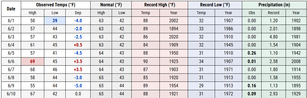
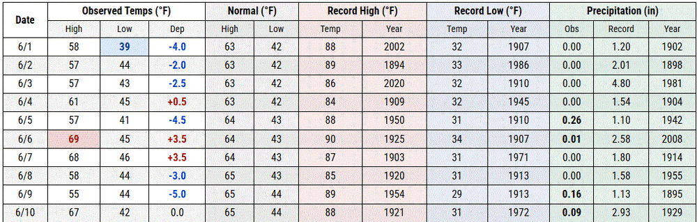
0.02" of rain this morning. Later this evening should net a little more. Hoping for some robust stms. Mid 40's n fog this morning.
-
Fog lifted for a while today. Sun came out, and it was beautiful, and muggy for a couple hrs before the fog returned, and temps cooled off.
-
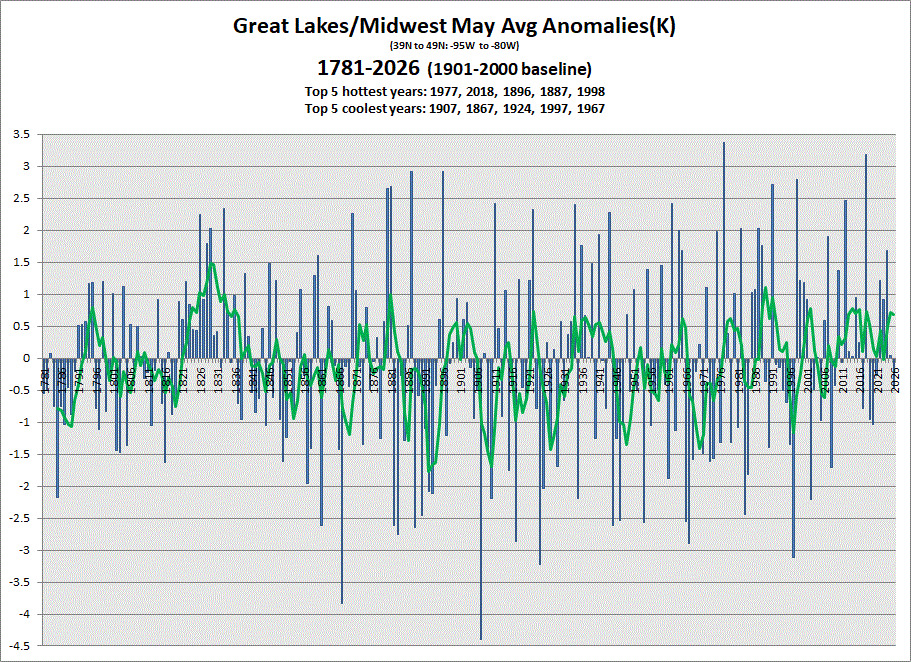
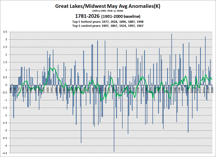
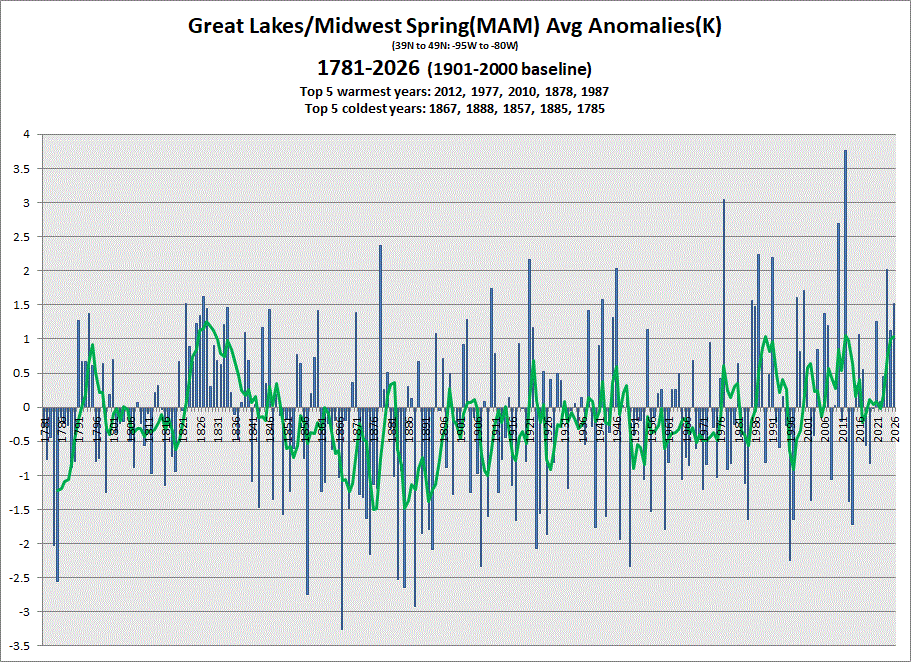
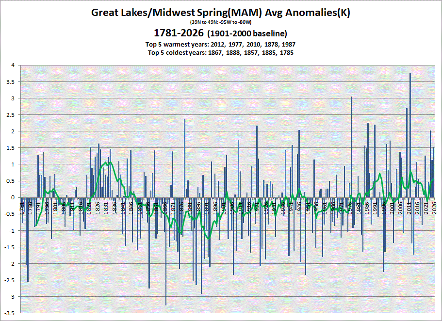
Early data in for May. Cooler one this year, but a warmer Spring overall. 5 & 10 yr trend charts shown respectively.
-
Starting tonight into tomorrow for my area.
-
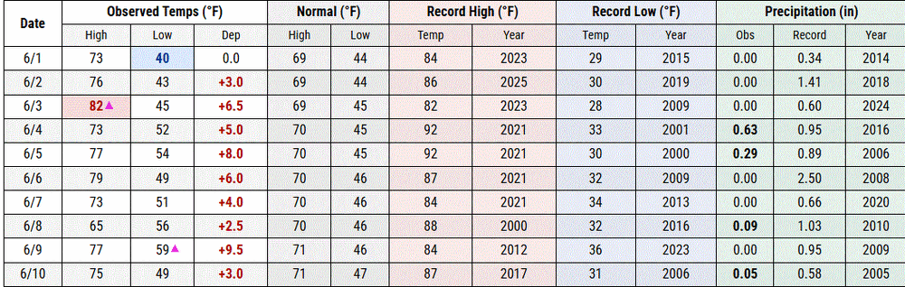
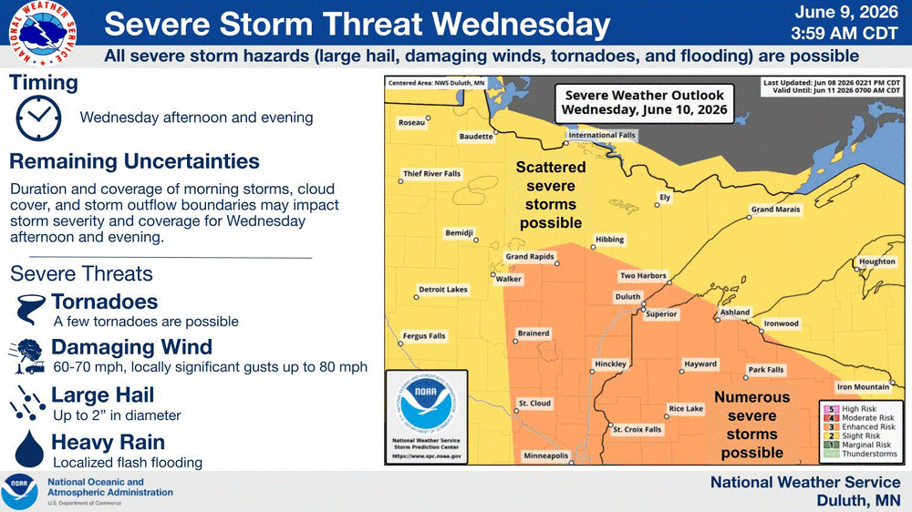
0.13" of rain yesterday with temps in the 50's with a Lake wind. Foggy morning. When that burns off, temps should be in the 70's today. 80's with higher dews inland are warranting a heat adv across NC & EC MN into N WI. Big stms out that way today. Tonight into tomorrow it will be my turn hopefully.
-
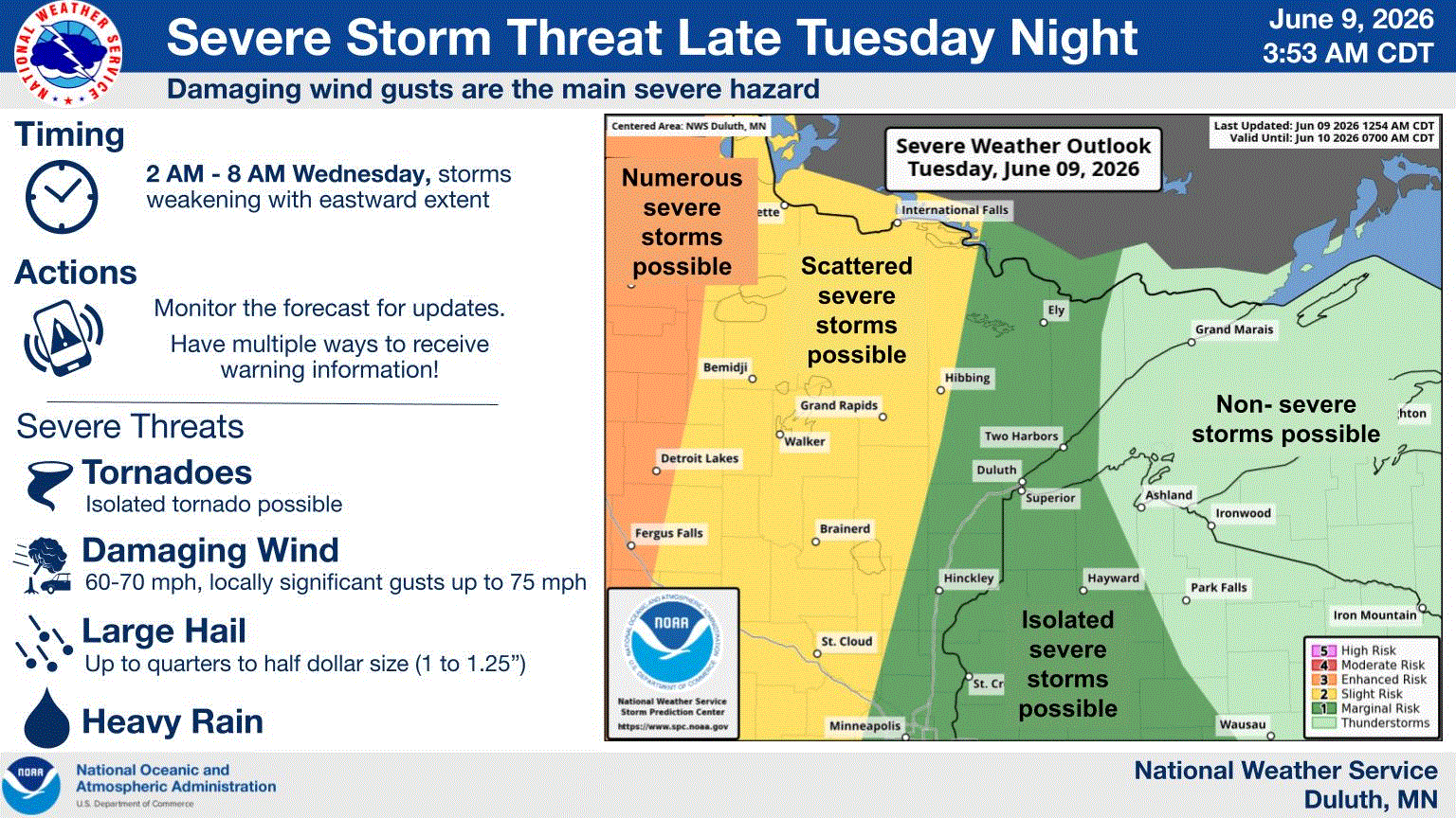
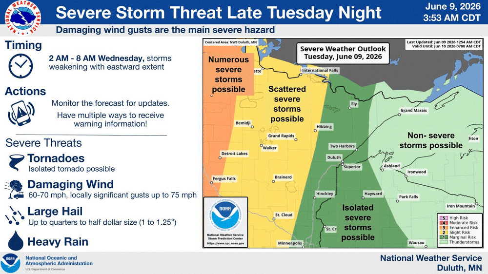
June 9 2002: Extensive flash flood begins across northwest Minnesota. 14.55 inches would fall over the next 48 hours near Lake of the Woods. Floodwaters cover the city of Roseau. The Roseau River looked like a large lake from a satellite view. For Tuesday, June 9, 2026 1953 - A tornado hit the town of Worcester MA killing ninety persons. The northeastern states usually remain free of destructive tornadoes, however in this case a low pressure system, responsible for producing severe thunderstorms in Michigan and Ohio the previous day, brought severe weather to New Hampshire and central Massachusetts. The tornado, up to a mile in width at times, tracked 46 miles through Worcester County. It mangled steel towers built to withstand winds of 375 mph. Debris from the tornado fell in the Boston area, and adjacent Atlantic Ocean. (David Ludlum) (The Weather Channel) 1972 - A cloudburst along the eastern slopes of the Black Hills of South Dakota produced as much as 14 inches of rain resulting in the Rapid City flash flood disaster. The rains, which fell in about four hours time, caused the Canyon Lake Dam to collapse. A wall of water swept through the city drowning 237 persons, and causing more than 100 million dollars property damage. (David Ludlum) 1987 - Lightning struck Tire Mountain near Denver CO, destroying two million tires out of a huge pile of six million tires. Thunderstorms spawned three tornadoes around Denver, and a man was killed at Conifer CO when strong thunderstorm winds lifted up a porch and dropped it on him. A thunderstorm near Compton MD produced two inch hail, and high winds which destroyed twenty barns and ten houses injuring five persons. (Storm Data) (The National Weather Summary) 1988 - Thunderstorms produced severe weather from North Carolina to the Central Gulf Coast Region. Hail in North Carolina caused more than five million dollars damage to property, and more than sixty million dollars damage to crops. Hail three and a half inches in diameter was reported at New Bern NC. Thunderstorms in the Central High Plains produced eighteen inches of hail at Fountain CO. The temperature at Del Rio TX soared to an all-time record high of 112 degrees. (The National Weather Summary) (Storm Data) 1989 - Severe weather abated for a date, however, showers and thunderstorms continued to drench the eastern U.S. with torrential rains. Milton, FL, was deluged with 15.47 inches in 24 hours. Record heat and prolonged drought in south central Texas left salt deposits on power lines and insulators near the coast, and when nighttime dew caused arcing, the city of Brownsville was plunged into darkness. (The National Weather Summary) Observances: 9 Tue National Mitchell Day 9 Tue National Strawberry Rhubarb Pie Day 9 Tue National Donald Duck Day 9 Tue National Call Your Doctor Day 9 Tue International Dark 'n Stormy® Day 9 Tue National Krewe of Tucks Day 9 Tue National Meal Prep Day 9 Tue National No Apologies Period Day
-
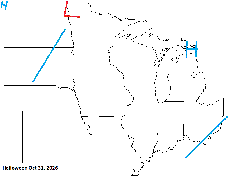
Halloween looks good for some, but late Oct looking unsettled.
-
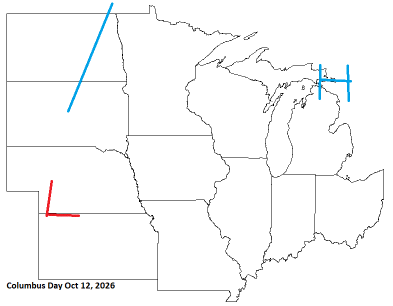
Columbus Day looks decent with inclement wx moving into the sub.
-
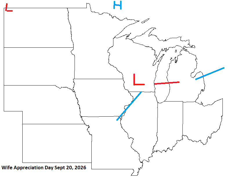
Wife Appreciation Day just before the Fall Equinox looks unsettled with some energy moving through the sub. Ok husbands, you know what to do today (I hope).
-
June 8 1972: 8 inches of rain falls in 7 hours at Madelia Township in Wantonwan County. 1893: Violent winds occur at Maple Plain from 1:30 to 2:15pm. A large frame house was moved 8 feet from its foundation. Many barns and hay sheds blown over by the wind. One barn was blown across Dutch Lake. For Monday, June 8, 2026 1953 - The worst tornado of record for the state of Michigan killed 116 persons. Flint MI was hardest hit. The tornado, half a mile in width, destroyed 200 homes on Coldwater Road killing entire families. (The Weather Channel) 1966 - A tornado ripped right through the heart of the capitol city of Topeka KS killing sixteen persons and causing 100 million dollars damage. The tornado, which struck during the evening, cut a swath of near total destruction eight miles long and four blocks wide. It was the most destructive tornado of record up until that time. (David Ludlum) 1974 - Severe thunderstorms spawned at least twenty-three tornadoes in Oklahoma during the afternoon and evening hours. One of the tornadoes struck the town Drumright killing sixteen persons and injuring 150 others. A tornado struck the National Weather Service office in Oklahoma City, and two tornadoes hit the city of Tulsa. Thunderstorms in Tulsa also produced as much as ten inches of rain. Total damage from the storms was around thirty million dollars. It was the worst natural disaster of record for Tulsa. (Storm Data) 1987 - Thunderstorms in the northeastern U.S. produced large hail and damaging winds in Vermont injuring two persons. Thunderstorms in Ohio produced wind gusts to 75 mph near Akron, and deluged Pittsfield with two inches of rain in thirty minutes. (The National Weather Summary) (Storm Data) 1988 - Overnight thunderstorms in Iowa produced 5.20 inches of rain at Coon Rapids. Thunderstorms in the Florida Keys drenched Tavernier with 7.16 inches of rain in 24 hours. Eleven cities in the central U.S. reported record high temperatures for the date. (The National Weather Summary) 1989 - Thunderstorms produced severe weather over the Central Gulf Coast Region during the day and evening. Severe thunderstorms spawned 17 tornadoes, including one which injured ten persons and caused a million dollars damage at Orange Beach, AL. Thunderstorm winds gusting to 90 mph killed three persons and injured four others at Mobile AL. Thunderstorms also deluged Walnut Hill and Avalon Beach, FL, with eight inches of rain. (Storm Data) (The National Weather Summary) Found a site that shows various observances. Very interesting. Looks like every day is some kind of "Something Day". I'll post these too with historical wx. 8 Mon Upsy Daisy Day 8 Mon National Best Friends Day 8 Mon World Oceans Day 8 Mon International Day of Action for Elephants in Zoos 8 Mon Name Your Poison Day 8 Mon Thomas Paine Day 8 Mon World Brain Tumor Day
-
Rain this morning. Welcome sight.
-
My tomorrow wx is SW of me tonight. Bring it! Need precip.
-
June 7 2011: The Twin Cities reach a high of 103 degrees, shattering the previous record high by 8 degrees. 1939: Grapefruit-sized hail falls in Rock County, killing hundreds of farm animals near Hills. For Sunday, June 7, 2026 1816 - A famous June snow occurred in the northeastern U.S. Danville VT reported drifts of snow and sleet twenty inches deep. The Highlands were white all day, and flurries were observed as far south as Boston MA. (David Ludlum) 1972 - Richmond VA experienced its worst flood of record as rains from Hurricane Agnes pushed the water level at the city locks to a height of 36.5 feet, easily topping the previous record of thirty feet set in 1771. (The Weather Channel) 1987 - Thunderstorms in the Laramie Mountains of eastern Wyoming produced golf ball size hail, and up to five inches of rain in just one hour. Half a dozen cities in the Upper Mississippi Valley reported record high temperatures for the date, including La Crosse, WI, with a reading of 97 degrees. (The National Weather Summary)(Storm Data) 1988 - Snow whitened some of the mountains of northern California and northwestern Nevada. Twenty-six cities in the central and eastern U.S. reported record high temperatures for the date, including Rapid City SD with a reading of 104 degrees, and Miles City, MT, with a high of 106 degrees. (The National Weather Summary) 1989 - Thunderstorms produced severe weather from southern Oklahoma and eastern Texas to northwestern Florida through the day and night. Thunderstorms spawned 22 tornadoes, including a dozen in Louisiana, and there were 119 reports of large hail and damaging winds. A strong (F-2) tornado at Gross Tete LA killed two persons, injured thirty others, and another strong (F-2) tornado injured 60 persons at Lobdell LA. Softball size hail was reported at Hillsboro TX. (The National Weather Summary) (Storm Data)
-
Had a good time yesterday chillin with family n friends at the grad party. Beautiful day with a Lake breeze that kept it comfortable in the 70's. Sun was still warm tho. Today will be different with a stiff Lake wind with temps in the 60's.