Brian D
-
Posts
3,110 -
Joined
-
Last visited
Content Type
Profiles
Blogs
Forums
American Weather
Media Demo
Store
Gallery
Everything posted by Brian D
-
Top 5 cold aftrn yesterday with highs in the upper 30's - 40's. I-Falls 38 (1st beating 39 1950/79), Hibbing 41 (t2nd), Duluth 42 (t7th), Brainerd 43 (3rd), Park Rapids 41 (t4th), St Cloud 45 (t4th), Minneapolis 46 (t3rd), and Rochester 47 (t5th). In WI, Ashland 44 (t5th), Eau Claire 44 (3rd), Rhinelander 43 (t4th), and La Crosse 47 (t5th).
-
Upper 20's/low 30's around the area this morning with a band of snow shwrs to my NE.
-
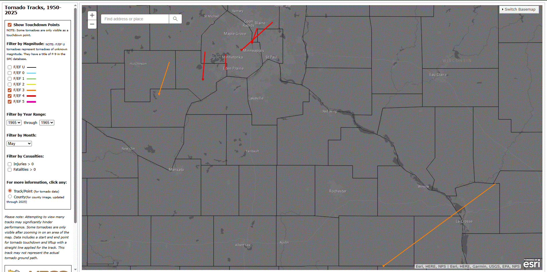
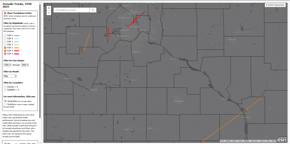
May 6 1965: 6 strong tornadoes, 4 of which were rated F4 on the Fujita Scale, devastate parts of east central Minnesota, including parts of the Twin Cities metro area. 14 people are killed, and 683 are injured. 2 of the F4 tornadoes hit Fridley. For Wednesday, May 6, 2026 1933 - Charleston, SC, was deluged with 10.57 inches of rain, an all- time 24 hour record for that location. (The Weather Channel) 1975 - A massive tornado hit Omaha, NE, killing three persons, injuring 133 others, and causing 150 million dollars damage. The tornado struck during the late afternoon moving northeastward through the industrial and residential areas of west central Omaha, and lifting over the northern section of the city. The twister, which cut a swath ten miles long and as much as a quarter of a mile wide, was the mostly costly in U.S. history up till that time. (David Ludlum) 1987 - Eighteen cities in California and Oregon reported record high temperatures for the date. Highs of 91 degrees at Portland OR, 101 degrees at Medford OR, and 104 degrees at Sacramento CA, were the warmest of record for so early in the season. (The National Weather Summary) 1988 - A major storm brought high winds to the western half of the country. A wind gust of 74 mph at Pueblo CO broke their May record established just four days earlier, and winds in the Arapahoe Ski Basin area of Colorado reached 85 mph. In North Dakota, the high winds reduced visibilities to near zero in blowing dust closing many roads. (The National Weather Summary) (Storm Data) 1989 - Sixteen cities in the north central U.S. reported record low temperatures for the date. Morning lows of 17 at Bismarck ND and 26 at Minneapolis MN were the coldest of record for so late in the season. A reading of 43 degrees at the start of the Kentucky Derby was the coldest in 115 years of records. Light snow was reported in the Upper Midwest, with an inch reported at Chicago IL. (The National Weather Summary) 1990 - Snow and high winds prevailed behind a Pacific cold front crossing the northwestern U.S. Wind gusts above 50 mph were reported in southeastern Idaho, and heavy snow blanketed the Cascade Mountains of Washington State, with twelve inches reported at Stampede Pass. (The National Weather Summary) NOTE: NWS MSP write up on the 1965 tornado outbreak https://www.weather.gov/mpx/60thAnnivesaryofMay06_1965_Tornados Screenshot of the event from MRCC Tornado tracking tool.
-
May 5 1965: At least 7 tornadoes hit southern Minnesota. This outbreak is a preview of what would happen the next day… For Tuesday, May 5, 2026 1917 - The same storm which a day earlier produced eight inches of snow in the Texas panhandle, produced a foot of snow at Denver CO, their heaviest snow of record for the month of May. (David Ludlum) 1930 - The temperature at College Park, VA, soared from 43 degrees to 93 degrees to begin an exceptional heat wave. (Sandra and TI Richard Sanders - 1987) 1987 - Unseasonably hot weather prevailed in the western U.S. A dozen cities in California reported record high temperatures for the date. Afternoon highs of 93 degrees at San Francisco, 98 degrees at San Jose, 100 degrees at Sacramento, and 101 degrees at Redding, were the warmest of record for so early in the season. The high of 94 degrees at Medford OR was also the warmest of record for so early in the season. (The National Weather Summary) 1987 - Parts of the western U.S. were in the midst of a blistering May heat wave. The reading of 100 degrees in Downtown Sacramento CA was their earliest of record. Sacramento CA established daily record highs on nine of eleven days between the 4th and the 14th. (The Weather Channel) 1988 - A stubborn low pressure system continued to drench the eastern U.S. with rain. Thunderstorms again produced large hail in North Carolina. (The National Weather Summary) 1989 - Thunderstorms swept across Georgia and the Carolinas during the late afternoon and evening hours spawning seventeen tornadoes. A tornado at Toccoa GA injured 15 persons, and a tornado at Chesnee SC killed two persons and injured 35 others. Five tornadoes in North Carolina accounted for five deaths, 88 injuries, and sixty million dollars damage. Thunderstorms also produced baseball size hail at Lake Murray SC, and wind gusts to 78 mph at Brooklyn MD. (The National Weather Summary) (Storm Data) 1990 - A strong Pacific cold front moving rapidly inland caused weather conditions at the east end of the Strait of Juan de Fuca in Washington State to quickly change from sunny and calm to westerly winds of 60 mph and ten-foot waves. Three recreational fishing boats capsized in heavy seas off Port Angeles resulting in five deaths. In California, temperatures soared above 90 degrees across much of the state. The high of 101 degrees in downtown Los Angeles was eight degrees hotter than their previous record for the date. (The National Weather Summary) (Storm Data)
-
30 and snow shwrs this morning. Brr!
-
May 4 1926: Morris goes from winter to summer temperatures in one day. The morning low was 32, followed by a high of 89. For Monday, May 4, 2026 1812 - A storm produced snow from Philadelphia to Maine. A foot of snow fell near Keene NH, and in Massachusetts, nine inches fell at Waltham, located near Boston. (David Ludlum) 1917 - A late season snowstorm in northwest Texas produced up to eight inches of snow in Potter County and Armstrong County. (David Ludlum) 1922 - Austin, TX, was hit twice by tornadoes which struck within thirty minutes of each other. Twelve persons were killed in the tornadoes. (The Weather Channel) 1977 - A tornado 500 yards in width struck Pleasant Hill, MO, severely damaging the high school and grade school. Only minor injuries were reported among the more than 1000 teachers and students due to excellent warnings and prior tornado drills. (The Weather Channel) NOTE: Thumbs up to that school district 1987 - Thunderstorms produced severe weather in the southeastern U.S., with South Carolina hardest hit. Thunderstorm winds toppled trees seventy feet high in Spartanburg County SC, and knocked homes off their foundations near Bishopville SC. (Storm Data) (The National Weather Summary) 1988 - Thunderstorms produced large hail in North Carolina, but brought welcome rains to much of the rest of the eastern U.S. Residents of New England finally saw sunshine after about a week of clouds and rain. (The National Weather Summary) (Storm Data) 1989 - Thunderstorms produced severe weather in the Southern Plains Region and the Lower Mississippi Valley. Thunderstorms spawned fifteen tornadoes, and there were 340 reports of large hail and damaging winds. Hail three inches in diameter, and 9.39 inches of rain, resulted in more than 130 million dollars damage at Monroe LA. Thunderstorm winds gusted to 100 mph at Epps LA and Fort Worth TX. A thunderstorm north of Mineral Wells TX produced high winds which unroofed a nightclub, turning it into a "topless club." (The National Weather Summary) (Storm Data) 1990 - Thunderstorms produced severe weather from the Lower Ohio Valley to Virginia and the Carolinas. A tornado at Augusta Springs VA killed two people and injured ten others, and another tornado caused 1.7 million dollars damage at Colonial Heights VA. Temperatures soared into the 90s in northern California. The high of 98 degrees in downtown Sacramento was their hottest reading of record for so early in the season. (The National Weather Summary) (Storm Data) NOTE: Having drills in school for different scenarios is a good thing.
-
First 70 this year in town yesterday. Was nice to have the window open. Shwrs moved through early this morning. Gusty W winds on tap today with highs in the 50's.
-
With the pattern for May, wouldn't surprise me that you get frosty even late in the month.
-
Going to be a beautiful day. Temps already in the the 50's this morning. Should be strong 60's this aftrn on a light NW wind.
-
May 3 1905: A 'mixed bag of weather' occurs in Minnesota. Western Minnesota is pelted with hail, while snow falls over the Arrowhead. For Sunday, May 3, 2026 1978 - Persistent thunderstorms caused widespread flooding in southeastern Louisiana and extreme southeastern Mississippi. Rainfall totals of ten to thirteen and a half inches were reported around New Orleans causing the worst flooding in thirty years. The water depth reached three to four feet in several hundred homes, and total property damage was estimated at one hundred million dollars. (David Ludlum) 1987 - Thunderstorms produced severe weather in Texas, Oklahoma and Kansas. Softball size hail was reported at Center Point TX, and a tornado caused three million dollars damage near Satanta KS. Heavy snow blanketed the foothills of eastern Colorado, with 18 inches reported at Divide. (The National Weather Summary) (Storm Data) 1988 - Thunderstorms brought much needed rains to the drought- stricken central U.S. Evening thunderstorms produced large hail in North Carolina. Baseball size hail was reported west of Mooresville NC. (The National Weather Summary) (Storm Data) 1989 - Thunderstorms produced severe weather in the Southern and Central Plains Region. Thunderstorm winds gusted to 72 mph at Graford TX, and baseball size hail was reported at Graham TX and Lake Kemp TX. (The National Weather Summary) (Storm Data) 1990 - A stubborn late season storm slowly crawled across southern Colorado the first three days of the month producing heavy snow from the San Juan Mountains to the southeast plains. The storm produced up to three feet of snow in the higher elevations of southern Colorado, and 18 to 22 inches of snow along the eastern slopes of the Central Mountains of New Mexico. Pueblo CO reported a record 10.6 inches of snow for the month as a result of the storm, and a record total for the winter season of 69.6 inches. (The National Weather Summary) (Storm Data) 1999 - On May 3, 1999, an unusual confluence of atmospheric conditions in Oklahoma spawned dozens of tornadoes that swept across the state in an hours-long parade of destruction. Thousands of homes were damaged or destroyed, and 19 counties became disaster areas. The worst toll was in human lives: 44 dead, including three children. Hundreds more were injured.(http://newsok.com/may3)
-
May 2 2013: A historic snowstorm dumps up to 18 inches of snow in southeast Minnesota and west central Wisconsin. Blooming Prairie receives 18 inches from this storm, and Eau Claire gets 9.3 inches. For Saturday, May 2, 2026 1899 - A storm buried Havre, MT, under 24.8 inches of snow, an all-time record for that location. The water equivalent of 2.48 inches was a record 24 hour total for the month of May. (The Weather Channel) 1920 - A swarm of tornadoes in Rogers, Mayes and Cherokee Counties in Oklahoma killed 64 persons. (David Ludlum) 1929 - Virginia's worst tornado disaster occurred. Six tornadoes, two of which were west of the Blue Mountains, killed 22 people. Twelve children and a teacher were killed at Rye Cove, in Scott County. Four schools were destroyed by the storms. (The Weather Channel) 1983 - Severe thunderstorms spawned twenty tornadoes across Michigan, Ohio, Pennsylvania and New York State. The tornadoes caused five deaths. (The Weather Channel) 1987 - Thunderstorms in the Lower Mississippi Valley produced golf ball size hail in northern Louisiana, and wind gusts to 77 mph at Lake Providence LA. Thunderstorms in Arkansas produced 4.20 inches of rain at Arkadelphia and 4.00 inches at Bismarck. (Storm Data) (The National Weather Summary) 1988 - A powerful storm produced snow and high winds in the Central Rockies and the Central High Plains Region. Snowfall totals in Colorado ranged up to 12 inches at Strasburg, and winds in southeastern Colorado gusted to 87 mph at Lamar. Snow and high winds created blizzard conditions in eastern Colorado and southeastern Wyoming. (The National Weather Summary) (Storm Data) 1989 - Thunderstorms developing to the north of a warm front produced severe weather in Oklahoma and Texas. There were 93 reports of severe weather. Thunderstorm winds gusted to 80 mph at Beattie, and baseball size hail was reported at Ranger and Breckenridge. Juneau AK reported a record high temperature of 72 degrees while Honolulu equaled their record low for the month of May with a reading of 60 degrees. (The National Weather Summary) (Storm Data) 1990 - Fourteen cities in Florida, Georgia and South Carolina reported record high temperatures for the date as readings soared into the 90s. Tampa FL reported a record high of 97 degrees, and Fort Stewart GA was the hot spot in the nation with a reading of 100 degrees. 1990 - Thunderstorms produced severe weather from northeastern Texas to western Arkansas during the evening and early nighttime hours. Thunderstorms spawned a tornado which injured thirteen persons at Paris TX, and produced baseball size hail at Rio Vista TX. Thunderstorm rains of four to seven inches caused flash flooding in west central Arkansas, southern and eastern Oklahoma, and northern Texas. (The National Weather Summary) (Storm Data)
-
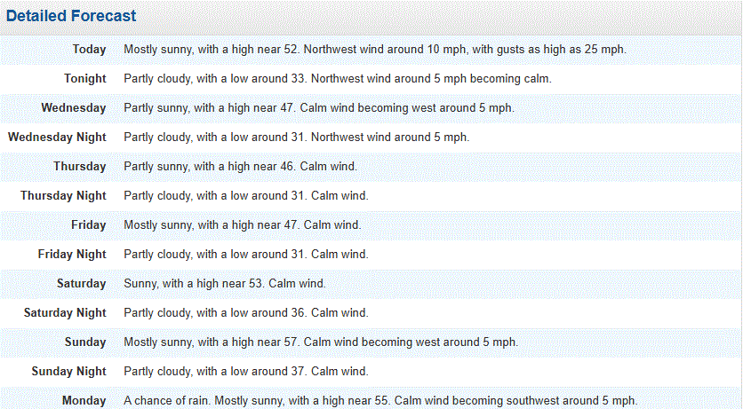
Chilly morning with temps in the upper 10's/20's. Yesterday was a cool one in the lower 40's. Warmer today in the 50's/60's. Only for the weekend as temps head back into the 40's for next week.
-
My modelling method would suggest the same probability for our sub. Lots of CAN air intrusion.
-
Rollercoaster temps for the 1st week of the month here in TH.
-
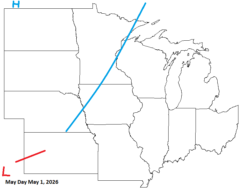
May 1 1966: Winter makes a last stab at Minnesota with a low of 5 at Cook. A widespread freeze hits the rest of the state. 1935: An unusually late snow and ice storm hits east central Minnesota. The heaviest ice accumulations are between St. Paul and Forest Lake and westward to Buffalo in Wright County, with accumulations of 1 to 1.5 inches on wires. The downtown Minneapolis weather bureau records 3 inches of snow. For Friday, May 1, 2026 1854 - The Connecticut River reached a level of nearly twenty-nine feet at Hartford (the highest level of record up until that time). The record height was reached in the midst of a great New England flood which followed sixty-six hours of steady rain. (David Ludlum) 1935 - Snow, ice and sleet brought winter back to parts of southeast Minnesota. Minneapolis received three inches of snow to tie their May record which was established in 1892. (1st-2nd) (The Weather Channel) 1954 - The temperature at Polebridge MT dipped to 5 degrees below zero to establish a state record for the month of May. (The Weather Channel) 1987 - Thunderstorms produced large hail and heavy rain in Texas. Baseball size hail pounded Dublin, and 3.75 inches of rain soaked Brady. (The National Weather Summary) (Storm Data) 1988 - Strong southerly winds ahead of a cold front crossing the Rocky Mountain Region gusted to 90 mph at Lamar CO. High winds created blinding dust storms in eastern Colorado, closing roads around Limon. (The National Weather Summary) (Storm Data) 1989 - Thunderstorms produced heavy rain in the southeastern U.S. Rainfall totals of 1.84 inches at Charlotte NC and 2.86 inches at Atlanta GA were records for the date. Strong thunderstorm winds uprooted trees in Twiggs County GA. (The National Weather Summary) (Storm Data) 1990 - Thunderstorms produced severe weather from northern Alabama to North Carolina. There were sixty-three reports of large hail or damaging winds, with hail four inches in diameter reported near Cartersville GA. Ten cities in the southeastern U.S. reported record high temperatures for the date as readings warmed into the 90s. Jacksonville FL reported a record high of 96 degrees. Late night thunderstorms over central Texas produced up to ten inches of rain in southern Kimble County and northern Edwards County. (The National Weather Summary) (Storm Data)
-
DLH for April avg temp 37.8 (-1.7),and precip 3.66" (+1.13). TH ended with 6.83" (+4.18) at CoCoRAHS site Two Harbors 2.0 ENE. 6.16" (+3.51") at the TH Co-op (3rd wettest). 2001 pcpn 8.83 1 1 1 0 1894 pcpn 6.71 2 2 2 0 *2026 pcpn 6.16 3 3 3 0 1948 pcpn 5.72 4 4 4 0 1968 pcpn 4.73 5 5 5 0
-
Been wildcat obs off n on over the yrs. Best pics yet.
-
Another cool day with a mix of rn/sn shwrs on tap.
-
Decent call. Front moving through, but the stronger front moved through a few days ago. Cooler wx already in play. A mix of precip across the N areas, as more cooler air moves into the sub. At least CO is getting some much needed precip with this pattern.
-
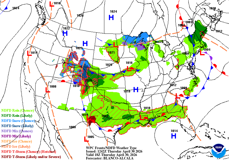
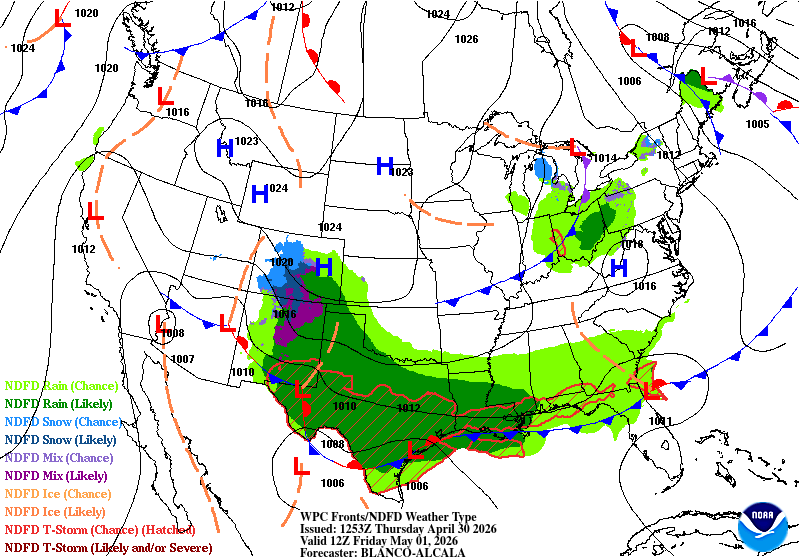
April 30 2004: After a high temperature of 91 on the previous day in the Twin Cities, the mercury tumbles to 47 degrees by the morning. St. Cloud sheds 50 degrees over 12 hours. 1967: Tornadoes hit southern Minnesota. Some of the towns affected were Albert Lea, Waseca, Wells, and Owatonna. For Thursday, April 30, 2026 1852 - A tornado, following the same track as the famous "Tri-state Tornado" of 1925, struck the town of New Harmony IND. Just sixteen persons were killed by the twister, due to the sparse settlement. The "Tri-state Tornado" killed 695 persons. (David Ludlum) 1953 - A tornado 300 yards in width leveled homes on the north side of Warner-Robins GA, and barracks on the south side of the Warner-Robins Air Force Base. (The Weather Channel) 1987 - Thunderstorms developing along a cold front produced severe weather in Idaho, Utah, Wyoming and Montana. Thunderstorms produced wind gusts to 100 mph in Lincoln, Mineral and Sanders counties. Twenty-three cities in the central and southeastern U.S. reported record high temperatures for the date. Memphis TN was the hot spot in the nation with a record high of 94 degrees. (The National Weather Summary) (Storm Data) 1988 - A cold front produced high winds in the southwestern U.S. Winds gusting to 90 mph in southwestern Utah downed power lines, and damaged trees and outbuildings. The high winds also downed power lines in Nevada, completely knocking out power in the town of Henderson. (The National Weather Summary) (Storm Data) 1989 - Thunderstorms produced severe weather in central and eastern Texas. Hail three inches in diameter was reported at Cool, and thunderstorm winds gusted to 80 mph at Hillsboro. For the first time of record Oklahoma City went through the entire month of April without a single thunderstorm. (The National Weather Summary) (Storm Data) (The Weather Channel) 1990 - Late afternoon and evening thunderstorms produced severe weather in southern Virginia and the Carolinas, with tennis ball size hail reported southeast of Chesnee SC. Thunderstorms moving over the Chesapeake Bay flooded U.S. Highway 50 on Kent Island MD with several inches of water resulting in a seventeen-mile long traffic jam. (The National Weather Summary) (Storm Data)
-
Snow showers this evening. Chilly day.
-
April 29 1984: Late season heavy snow blankets the Twin Cities with 6.6 inches. 1940: Heavy rain falls in Duluth, with a daily total of 3.25 inches. For Wednesday, April 29, 2026 1905 - The town of Taylor, in southeastern Texas, was deluged with 2.4 inches of rain in fifteen minutes. (The Weather Channel) 1910 - The temperature at Kansas City, MO, soared to 95 degrees to establish a record for the month of April. Four days earlier the afternoon high in Kansas City was 44 degrees, following a record cold morning low of 34 degrees. (The Weather Channel) (The Kansas City Weather Almanac) 1963 - A tornado, as much as 100 yards in width, touched down south of Shannon, MS. The tornado destroyed twenty-seven homes along its eighteen mile path, killing three persons. Asphalt was torn from Highway 45 and thrown hundreds of yards away. Little rain accompanied the tornado, so it was visible for miles. (The Weather Channel) 1973 - The Mississippi River reached a crest of 43.4 feet, breaking the previous record of 42 feet established in 1785. (David Ludlum) Note: Where?? LOL 1987 - A storm off the southeast coast of Massachusetts blanketed southern New England with heavy snow. Totals of three inches at Boston MA, 11 inches at Milton MA, and 17 inches at Worcester MA, were records for so late in the season. Princeton MA was buried under 25 inches of snow. (The National Weather Summary) (Storm Data) 1988 - Thunderstorms produced large hail and high winds in central Texas. Baseball size hail was reported at Nixon, and wind gusts to 70 mph were reported at Cotulla. Heavy rain in Maine caused flooding along the Pemigewassett and Ammonoosuc Rivers. (The National Weather Summary) (Storm Data) 1989 - Thunderstorms produced severe weather in Arkansas, Louisiana and eastern Texas, with more than 70 reports of large hail and damaging winds. Softball size hail was reported at Palestine TX. Hail as large as tennis balls caused ten million dollars damage around Pine Bluff AR. (The National Weather Summary) (Storm Data) 1990 - A storm system crossing northern New Mexico blanketed parts of the Rocky Mountain Region and the Northern High Plains with heavy snow, and produced blizzard conditions in central Montana. Much of southern Colorado was buried under one to three feet of snow. Pueblo tied an April record with 16.8 inches of snow in 24 hours. Strong canyon winds in New Mexico, enhanced by local showers, gusted to 65 mph at Albuquerque. Afternoon temperatures across the Great Plains Region ranged from the 20s in North Dakota to 107 degrees at Laredo TX. (The National Weather Summary) (Storm Data)
-
After 6+" of rain this month, this looks good. Nice n mellow with seasonable temps in town. A couple cooler days, but not too bad.
-
April 28 1994: Heavy snow falls over parts of Minnesota with 7.5 inches at Tower and 4.5 inches in the Twin Cities. 1966: A heavy snowstorm leaves 10 inches of snow on the ground across a wide chunk of northern Minnesota. For Tuesday, April 28, 2026 1921 - A severe hailstorm in Anson County, NC, produced hail the size of baseballs. Gardens, grain fields and trees were destroyed. Pine trees in the storm's path had to be cut for lumber because of the hail damage. (The Weather Channel) 1928 - A coastal storm produced tremendous late season snows in the Central Appalachians, including 35 inches at Bayard WV, 31 inches at Somerset PA, and 30 inches at Grantsville MD. High winds accompanying the heavy wet snow uprooted trees and unroofed a number of homes. The storm caused great damage to fruit trees and wild life. (David Ludlum) (The Weather Channel) 1987 - Twenty cities in the western and central U.S. reported record high temperatures for the date. Highs of 95 degrees at Houston TX, 95 degrees at Lake Charles LA, and 94 degrees at Port Arthur TX, were April records. (The National Weather Summary) 1988 - Miami, FL, hit 92 degrees, marking a record eight days of 90 degree heat in the month of April. Squalls produced snow in the Washington D.C. area. Belvoir VA reported a temperature reading of 57 degrees at the time the snow began. (Storm Data) (The National Weather Summary) 1989 - Strong northerly winds and heavy snow ushered cold air into the north central U.S. Snowfall totals in Montana ranged up to 20 inches at Miles City. Thunderstorms produced severe weather from eastern Texas to the Southern Appalachians and the southern Ohio Valley. Hail four and a half inches in diameter was reported at Keller TX and White Settlement TX. (Storm Data) (The National Weather Summary) 1990 - Thunderstorms produced severe weather in the southeastern U.S. during the day. Severe thunderstorms spawned four tornadoes, including one which injured four persons at Inman SC. There were also more than one hundred reports of large hail and damaging winds, with better than half of those reports in Georgia. Strong thunderstorm winds injured four people at Sadler's Creek SC. (The National Weather Summary) (Storm Data) Twenty-nine cities in the northeastern U.S. reported record high temperatures for the date as readings soared into the 80s and lower 90s. Highs of 88 degrees at Binghamton NY, 94 degrees at Buffalo NY, 89 degrees at Erie PA, 90 degrees at Newark NJ, 93 degrees at Rochester NY and 92 degrees at Syracuse NY, were records for the month of April. (The National Weather Summary)
-
1.75" of rain yesterday. What a soaker. Grass is greening up. Some warmer temps, and the trees will bud out. 6.38" for the month from the CoCoRahs site just NE of town. Very wet.