Brian D
-
Posts
2,222 -
Joined
-
Last visited
Content Type
Profiles
Blogs
Forums
American Weather
Media Demo
Store
Gallery
Everything posted by Brian D
-
Snow ended here not long ago. Measured 1.0". A little more winter looking now in town. Winds should kick up in the a.m. n blow it around.
-
Clipper starting to make its presence felt here this morning with flurries. Looks like the biggest snow totals will be to my N to NE with some stout winds tomorrow.
-
Lows in the sd's n teens. Min's hit just after midnight then started to rise as clouds moved in overnight. Looking forward to the clipper moving through Tues. Looks like 1-3". Would get more if the center of LP swung down a little more to get E winds, but more of a WAA with W-SW winds. Time to build snowpack in town. Already 2-4" otg in the higher terrain.
-

Winter 2024-25 Medium/Long Range Discussion
Brian D replied to michsnowfreak's topic in Lakes/Ohio Valley
Looks like the models are trying to work out an active stm pattern as they close in on mid Dec. That's what I'm seeing too. Hopefully I will get in on some good synoptic/lake enhanced snows. -
Cold morning with lows in the single digits +/- around the area. Wind chills between -10 to -20.
-
Gaylord's 24.8" beat the calendar day (midnight-midnight) record of 17.0"(3/9/42). That's a pounding. Lots more to come over the next few days with LES, and a clipper zipping through next week with more LES after that.
-
1-3" of snow across areas of N MN. N WI into Ironwood, MI has seen 1-8" so far. Sault Ste. Marie reporting 23" at a location there. Must've had a band set up over that particular location as other reports there are 8-12". Looks like 8-12" being reported across some locations across the UP MI in general.
-
Cold, with flurries for Thanksgiving. LES setting up across N WI, into the UP MI. Briefly made it into the upper 20's at midday today. Seasonably colder conditions the next couple days with highs in the mid 20's, and lows in the single digits to teens (nearer the Lake).
-
Good forecast for Thanksgiving. Evolution was a little different than anticipated. We have a trough swinging in from the N, and a system in the S areas moving through Wed into early Thurs am. But a blustery, cold Thanksgiving was what I saw as the end result with plenty of LES. Weekend call not good, as LP gets squelched by another area of HP as it moves out of the W into KS over the weekend. HP quicker than I thought. Mid month stm brought good rains, and my call for a cooler Nov busted horribly. Thought early Nov would be more seasonable to cooler with mid month much milder, and a colder end. 2 of 3 isn't bad, but early Nov threw the final call way off. That's OK, as it was nice to have extended mild wx. Probably going to pay for it tho.
-
10-15 away from the Lake, around 20 on the shore this morning. Seasonable wx for a change. So starts winter.
-
Winter 2024-25 Medium/Long Range Discussion
Brian D replied to michsnowfreak's topic in Lakes/Ohio Valley
Looking at Dec from my modelling method, I'm going with colder early Dec, but a switch in mid Dec to a milder, wetter pattern (more stm chance my way), before things switch out after the solstice to a colder pattern again. Actually could see an avg to below (possibly well below for some) Dec in the books to end the year for sub as a whole. We shall see. -
Light, wet snow still falling at 10 am with maybe an inch on the grass here in town. 2-3" being reported across the area early this morning. Final totals will be a little bit more.
-
Light snow off the Lake starting already. This was a bit unexpected. Could end up with a little more along the shore here in town than forecast. We'll see how the rest of the day unfolds.
-
A bit of snow on tap tonight into tomorrow am. Higher terrain could see up to 6". Looks like winter is starting to settle into the region. Here in town, very little with the warmer waters of the Lake keeping temps right around/just above freezing on an E wind. Typical this time of year.
-
Windy am here under clear skies. N winds running 30-40+ with 50+ being reported up around Grand Marais. Gale/Storm warnings for the Lake.
-
Snow showers developing in my area with some flurries coming down at the moment. Flow still from the SW here.
-
2.98" of rain from this system. 3.99" for the month so far, which is nearly double the avg. Ground soaked up most of it. It was thirsty. Looks like more seasonable wx on tap which means a little more early winter-like wx.
-
Wet n windy night into this morning. Already reports of 1.50 -3" of rain, and it's still raining. Winds running up to 50 mph. There is a site near Silver Bay that has reported wind gusts up to 83 mph from the NE. It sits on a ridge about 40 ft above the water on the shoreline. The terrain rises fast there, so it seems the wind is funneling a bit along that stretch. Preliminary Local Storm Report National Weather Service Duluth MN 909 AM CST Tue Nov 19 2024 ..TIME... ...EVENT... ...CITY LOCATION... ...LAT.LON... ..DATE... ....MAG.... ..COUNTY LOCATION..ST.. ...SOURCE.... ..REMARKS.. 0750 AM Rain Finland 47.41N 91.25W 11/19/2024 M2.96 Inch Lake MN Cocorahs Cocorahs station MN-LK-52 Finland 0.1 S. 0700 AM Rain 3 SE Finland 47.38N 91.20W 11/19/2024 M2.80 Inch Lake MN CO-OP Observer CO-OP Observer station WLFM5 Wolf Ridge. 0845 AM Rain 1 NNW Beaver Bay 47.27N 91.31W 11/19/2024 M2.60 Inch Lake MN Mesonet Mesonet station BRBM5 Beaver R nr Beaver Bay. 0700 AM Rain 1 SSE Two Harbors 47.02N 91.66W 11/19/2024 M2.30 Inch Lake MN CO-OP Observer CO-OP Observer station TOHM5 Two Harbors.
-
They just upped the potential rain totals for the North Shore. Now isolated 4" possible along the higher terrain, along with a Wind adv for 40-50 mph wind gusts. Too bad this wasn't a winter storm. It would be awesome.
-
This will be most welcome! Isolated 3" also possible along the shore.
-
Pivotal Weather, and Tropical Tidbits Weather sites also have the long range Euro now. (360 & 144)
-
Sure has been nice. TH, tho, is 2nd driest (2.38") Sept 1-Nov 16 behind 1976 (2.05"), so the rains will be really nice. As much as I hate the cloudy, overcast stretches when the days are short, the precip will be most welcome. Temps looking to go back to more seasonable levels, so I actually may have a chance to measure some white stuff in a week.
-
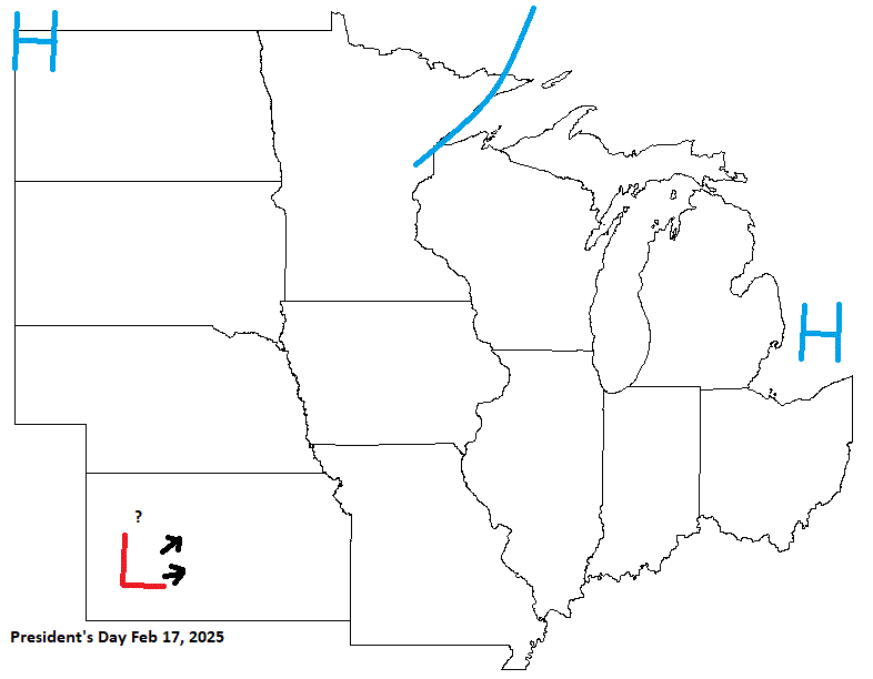
Valentine's day (14th), and President's Day (17th) are next on the calendar. Valentine's Day is looking cold after the frontal passage, but a little energy may sneak in affecting the SE sub, along with any LES that will be generated for some. President's Day needs to watched as HP moves through, and energy from the W possibly moves out, and into our sub along a frontal passage from CAN.

-
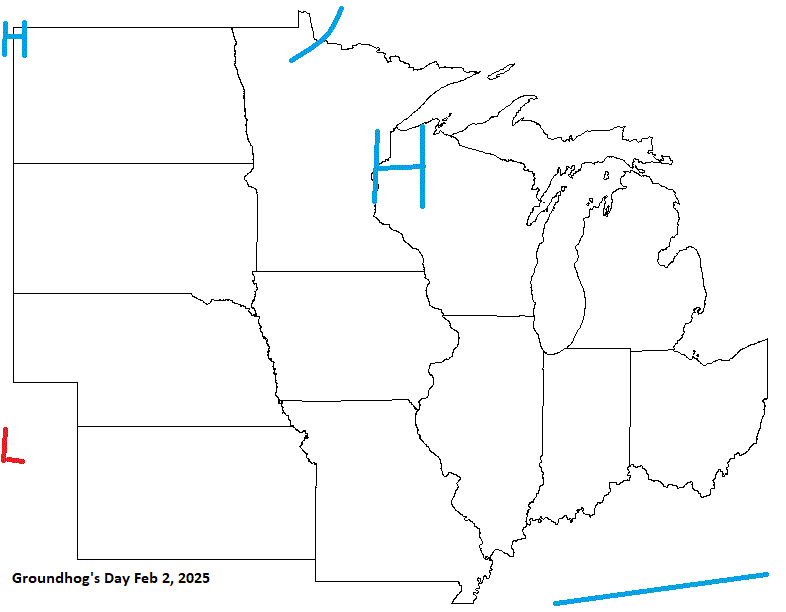
Groundhog's day looks fair, and rather cold. Probably the coldest wx of the winter so far with what looks like a trough digging in starting late Jan into early Feb. That should get the LES engine roaring.
-
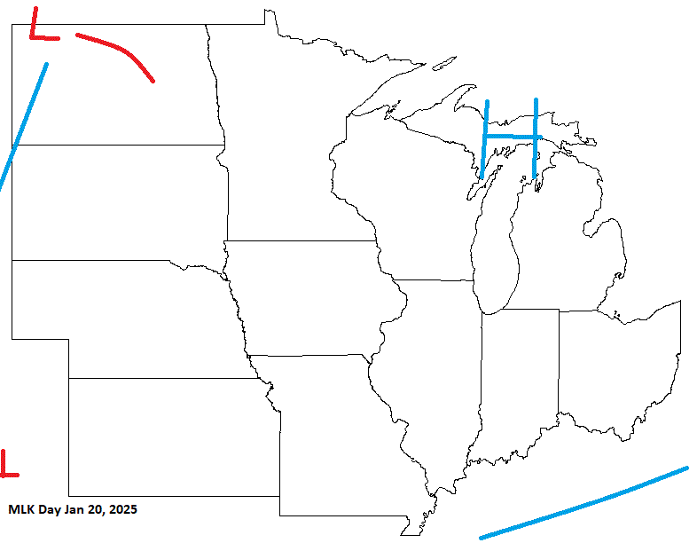
Another year on tap. Time sure is flying. The New Year's Day forecast is coupled with New Year's Eve Day in the "Holiday Forecasts 2024" thread. Starting off with MLK day, it looks like a ridge of HP will be over the sub bringing in chilly wx, and LES potential for some.