MN Transplant
-
Posts
17,845 -
Joined
-
Last visited
Content Type
Profiles
Blogs
Forums
American Weather
Media Demo
Store
Gallery
Everything posted by MN Transplant
-
Yeah, IAD 90 after a low of 54 today! So, IAD hit 90 in September and still had a negative daily departure. BWI 87, DCA 85.
-
The GFS is broken. The NAM's 95ish makes more sense.
-
It has never hit 100 at Dulles in September.
-
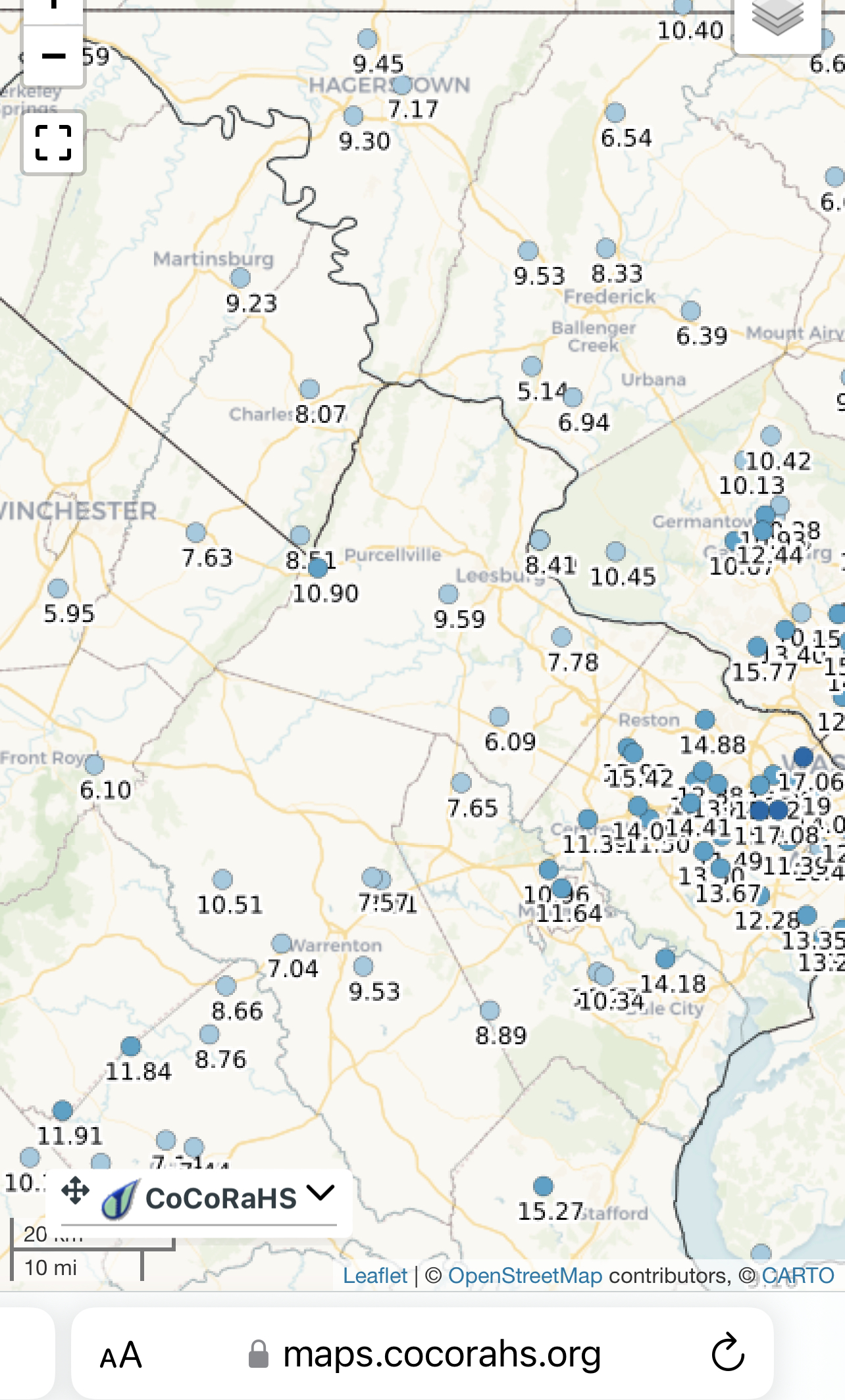
A truly remarkable W-E gradient in precipitation this meteorological summer.
-
Euro with more realistic mid-90s now for next week.
-
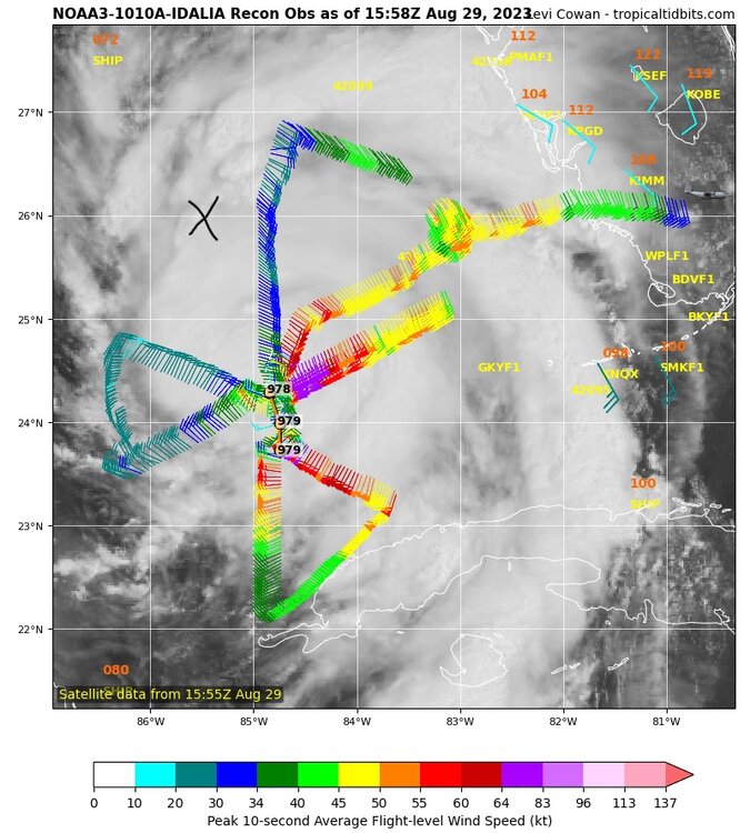
Curious about how Valdosta will fare. 65 miles from the coast, which at 15mph is 4-5 hours after landfall.
-
With visualization of the HAFS-B location this evening. I’m skeptical it gets that far west.
-
If you look at the HAFS-B from 06z, which seems to be about the west most model, it swings out from 85W to 85.5W before coming back east. It’ll be interesting to see if we get a westerly component as the day goes on.
-
How far would you consider going west? I could imagine Perry even being in play.
-
Fully agree.
-
I’m mobile so I’m not sure I’m getting this right, but I’m seeing very few major hurricane landfalls in the Big Bend area, and really from Appalachicola to Tampa. https://coast.noaa.gov/hurricanes/#map=6.76/29.139/-83.246&search=eyJzZWFyY2hTdHJpbmciOiJGbG9yaWRhLCBVU0EiLCJzZWFyY2hUeXBlIjoiZ2VvY29kZWQiLCJvc21JRCI6IjE2MjA1MCIsImNhdGVnb3JpZXMiOlsiSDUiLCJINCIsIkgzIl0sInllYXJzIjpbXSwibW9udGhzIjpbXSwiZW5zbyI6W10sInByZXNzdXJlIjp7InJhbmdlIjpbMCwxMDMwXSwiaW5jbHVkZVVua25vd25QcmVzc3VyZSI6dHJ1ZX0sImJ1ZmZlciI6NjAsImJ1ZmZlclVuaXQiOlsiTmF1dGljYWwgTWlsZXMiXSwic29ydFNlbGVjdGlvbiI6eyJ2YWx1ZSI6InllYXJzX25ld2VzdCIsImxhYmVsIjoiWWVhciAoTmV3ZXN0KSJ9LCJhcHBseVRvQU9JIjp0cnVlLCJpc1N0b3JtTGFiZWxzVmlzaWJsZSI6dHJ1ZX0=
-
It went completely off the deep end maybe 1-2 months ago. There was some discussion about the land surface being a problem, but it looked like it was only in the long range. It wasn’t. My hometown has an all-time high of 107 and it was trying to pump out like 110-113 from a few days out. The reality was 100.
-
Periods of 5+ days with at least 6" of snow on the ground at DCA (modern era) 1958 (Feb 16-20, max 14") 1961 (Jan 27-31, Max 9"), (Feb 9-14, Max 10") - 17 of 25 days in this stretch 1966 (Jan 30-Feb 3, Max 16") 1979 (Feb 13-Feb 23, Max 22") 1982 (Jan 21-29, Max 10") 1983 (Feb 12-16, Max 6") - Highs in the 50s the last two days 1987 (Jan 23-Feb 2, Max 18") 1996 (Jan 7-17, Max 20") 2003 (Feb 16-22, Max 16") 2009 (Dec 19-25, Max 16") 2010 (Feb 6-20, Max 18")
- 921 replies
-
- 11
-

-

-
Nice 0.74" to break a short dry spell of just over a week.
-
2023 Mid-Atlantic Severe Wx Thread (General Discussion)
MN Transplant replied to Kmlwx's topic in Mid Atlantic
- 2,785 replies
-
- 11
-
-
- severe
- thunderstorms
- (and 3 more)
-
2023 Mid-Atlantic Severe Wx Thread (General Discussion)
MN Transplant replied to Kmlwx's topic in Mid Atlantic
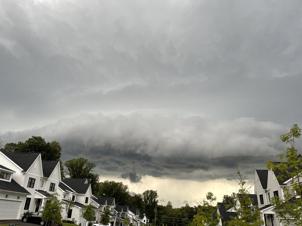
Severe warned storm headed towards the DC metro. -
I don’t post in the long range thread because I don’t follow this stuff as closely as you all do, but I have to say that while the globe is clearly warming and things are changing, we are less than 10 years removed from a couple of really cold and pretty snowy winters. Hell, we almost put up a -10 for the month of February 2015. The climate is changing but all is not lost.
-
The GFS has completely fallen apart as far as how deep it is mixing the boundary layer. It has been missing by 10+ degrees from a few hours out in the Midwest heat wave. Ignore the surface temps from the operational runs. That said, still nasty out there to our west. 100/78 at OHare today.
-
12z Euro trying to home brew. Eastern Gulf storm at 150.
-
90/80 at 11am at OHare. Worse in other parts of the Midwest. All glory to the eastern trough.
-
Hmmm, pass. Public Information Statement National Weather Service Twin Cities/Chanhassen MN 305 PM CDT Tue Aug 22 2023 ...MAXIMUM HEAT INDEX REPORTS TODAY AS OF 3 PM... Location Heat Idx. Time/Date Provider U.s.169 - Mankato - Mp 52 120 F 0225 PM 08/22 MESOWEST Spring Lake Township 119 F 0251 PM 08/22 MESOWEST T.h.110 - Inver Grove Hts - 119 F 0230 PM 08/22 MESOWEST T.h.60 - Madelia - Mp 86 118 F 0220 PM 08/22 MESOWEST U.s.169 - Henderson - Mp 86 118 F 0220 PM 08/22 MESOWEST Hanover 117 F 0250 PM 08/22 MESOWEST Jordan 117 F 0251 PM 08/22 MESOWEST Buffalo AP 117 F 0255 PM 08/22 AWOS Corcoran 116 F 0250 PM 08/22 MESOWEST Minneapolis 116 F 0250 PM 08/22 MESOWEST I-90 - Blue Earth - Mp 119 116 F 0240 PM 08/22 MESOWEST T.h.19 - Morton - Mp 78 116 F 0250 PM 08/22 MESOWEST 1 W Becker 115 F 0220 PM 08/22 NDAWN Rockford 115 F 0240 PM 08/22 MESOWEST Eden Prairie AP 115 F 0253 PM 08/22 ASOS Fairmont AP 115 F 0156 PM 08/22 AWOS Princeton AP 115 F 0255 PM 08/22 AWOS T.h.7 - New Germany - Mp 161 115 F 0200 PM 08/22 MESOWEST I-494 - Minnetonka - Mp 18 115 F 0245 PM 08/22 MESOWEST Carver 3S 115 F 0249 PM 08/22 RAWS
-
It is amazing how we don't even get the rollover heat this year. Bless the eastern trough.
-
I was 88 yesterday, definitely a bust low with the reduced solar input.
-
Spire is a private company who is in the low-earth orbiting satellite game. They are trying to assimilate proprietary satellite data to improve models. They also want to sell their data to NOAA and Congress is on board with the private sector providing data.
-
2023 Mid-Atlantic Garden, Lawn, and Other Green Stuff Thread
MN Transplant replied to mattie g's topic in Mid Atlantic
This may be as lively as our grass has looked as we approach late August. Even in the record precip year (2018) there was a short span of no rain in July that torched it. The continuous rain here since late June has done the job.