MN Transplant
-
Posts
17,947 -
Joined
-
Last visited
Content Type
Profiles
Blogs
Forums
American Weather
Media Demo
Store
Gallery
Everything posted by MN Transplant
-
Jan Medium/Long Range Disco 2: Total Obliteration is Coming
MN Transplant replied to Jebman's topic in Mid Atlantic
Just a completely different evolution than the Euro. That said, the players are there. The euro pairs the shortwave in the SW with the trough diving down through the Plains. The GFS has both of these things, but doesn't sync them up. -
Tuesday, January 9 Rain and Wind Storm
MN Transplant replied to Weather Will's topic in Mid Atlantic
Just for fun, the wind accumulation product from Windy provides the peak modeled wind gust. Let's see how they do at DCA: NAM 3k (06z): 57mph HRRR (13z): 60mph (!) GFS (06z): 63mph Euro (06z): 49mph ICON (06z): 54mph -
Tuesday, January 9 Rain and Wind Storm
MN Transplant replied to Weather Will's topic in Mid Atlantic
You are correct. The HRRR has definitely stepped up winds since yesterday. -
Jan Medium/Long Range Disco: Winter is coming
MN Transplant replied to stormtracker's topic in Mid Atlantic
973 low making landfall in coastal Maine with Caribou switching over to rain. -
Jan Medium/Long Range Disco: Winter is coming
MN Transplant replied to stormtracker's topic in Mid Atlantic
It’s not the same track. -
Tuesday, January 9 Rain and Wind Storm
MN Transplant replied to Weather Will's topic in Mid Atlantic
12z HRRR looks far more realistic with the surface wind gusts than the NAM. Peak wind gusts via Windy. Reds are 40s, purples are 50s.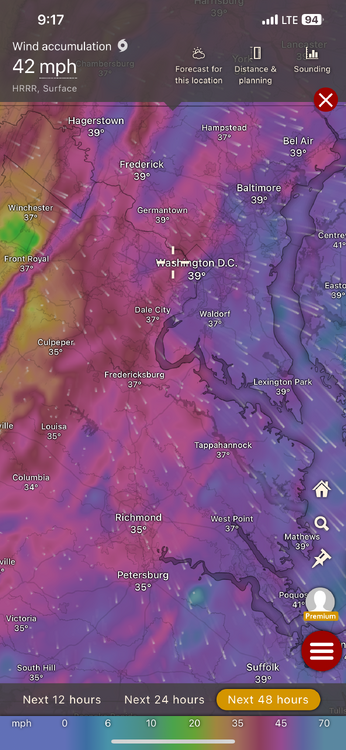
-
Tuesday, January 9 Rain and Wind Storm
MN Transplant replied to Weather Will's topic in Mid Atlantic
A causal reminder that, inland, we don't typically get big winds with SE flow. It generally stays elevated. That said, the NWS P&C for DC Tuesday evening has 30G45mph which is solid. -
35.1. The steady rain has started. Was in downtown DC earlier and never saw a flake. Sleet to rain.
-
33.3 here. Most of downtown DC is in the 36 range.
-
23.2, which was colder than any December day, but not as cold as Nov. 29th.
-
If only we had that track in Jan/Feb…
-
For this storm, that is a NAMming around DC. I like how the model R/S line stalls a bit at 18-19z before completely blowing past us.
-
The NAM has been bone dry so far. Significant outlier.
-
The NAM is really dry and weak. The Euro is 8mb deeper and wetter.
-
925 temps at DCA at 00z: +5 or +6
-
This is a bad run for 95
-
Does that account for a close mow? It is wild that this turned into a Saturday only event.
-
2” of rain just east of DC. I’m ignoring this one.
-
988 Cape May. We toss.
-
Snow maps are going to struggle on the boundary. Soundings and QPF are the way to go. I’m modestly happy with this run sitting on the western DC Beltway.
-
The column is holding on for dear life from 18 to 21z in the DC area. It eventually falls, but there’s almost 0.6” precip by 21z. Ratios would suck, but it would be a few inches of snow first in this scenario.
-
GFS isn’t terrible all things considered. It is so dry coming in that we get solid evaporational cooling. Precip totals are back up closer to an inch.
-
Forgetting the thermals for a second, the improvement in QPF from 12 to 18z is notable. We are back over 1” region wide.
-
Jan Medium/Long Range Disco: Winter is coming
MN Transplant replied to stormtracker's topic in Mid Atlantic
Not worth fretting about. Column is fine and heavy snow accumulates. Our risk is track. -
Jan Medium/Long Range Disco: Winter is coming
MN Transplant replied to stormtracker's topic in Mid Atlantic
CoD has me at 15" 10:1, 10" Kucera, and 2" snow depth. LOL