

MN Transplant
-
Posts
16,377 -
Joined
-
Last visited
Content Type
Profiles
Blogs
Forums
American Weather
Media Demo
Store
Gallery
Posts posted by MN Transplant
-
-
On 8/9/2023 at 2:32 PM, MN Transplant said:
Raining. Interesting.
Again.
-
 1
1
-
-
26 minutes ago, BlizzardNole said:
Surprised to see these pop ups this afternoon. Hoping for good rain tomorrow
I was oggling the 110-117 degree heat index readings in south FL and found this (bad reading but wild to look at). Beach day?
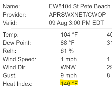
The accurate readings from south FL are bad enough. 94/80 as a ballpark reading.
-
38 minutes ago, Eskimo Joe said:
Details at 5, 6, and 11.
12z NAM Nest did have some showers around. 0.05” here
-
18 hours ago, nw baltimore wx said:
More travel banter but we survived last night’s storms and got up early to drive up to Lake Louise. Decided on the Plain of Six Glaciers hike.
Hopefully all have their power back on and damage was minimal. One of my travel companions that lives in my neighborhood at home is still without power and she got an alert it won’t be back on until Friday at 11pm. Nuts to that. We’re off to Jasper tomorrow for a few days.


We are planning on that trip sometime in the next 5 years. Are you happy with the time of year?
-
Raining. Interesting.
-
1
-
-
1.56”, with the majority coming in the 11pm downpour. Over 2” when adding in the prior day.
-
Little cell merger about to happen west of Stafford
-
2
-
-
Just now, MN Transplant said:
The striations in the TBWI data are fun.
-
8
-
-
3 minutes ago, WxWatcher007 said:
Some 80 mph velocities showing up just east of Fort Meade.
The striations in the TBWI data are fun.
-
1
-
-
Power outages tame closer into DC in Virginia, but more extensive out by Marshall/Markham/Delaplane/Upperville with that cell from earlier.
DCA to 52mph.
-
1
-
-
7 minutes ago, SnowenOutThere said:
Got a max wind gust of … 14.8 mph so uh that counts for something.
There's a reason why SPC talks about "within 25 miles". There just aren't many events that pan out other than in very localized places. We're seeing it here with Westminster and others. In Fairfax County, we are going to see a small stripe of damage from Manassas to the east, but nothing else. I also gusted in the 20s and the rain is actually not impressive for how the radar looks. Big drop bias.
-
4
-
-
Round 2 entering VA. HRRR says we storm again around 9pm.
-
Manassas airport gusted to 59
-
2
-
-
2 minutes ago, yoda said:
Uh oh @MN Transplant @mattie g @H2O
Mattie's out of town and this thing is headed right to Burke. LOL.
-
 3
3
-
-
Just got the cell phone alert for 80mph.
-
TDCA with 70+ headed toward Manassas
-
3
-
-
3 minutes ago, NorthArlington101 said:
Something popping up ahead of the line near Fair Oaks. Will be interesting to see if it can take off.
It's going to be on me before it has time to take off, if it does.
-
76mph pixel on the tor warned cell just entering Loudoun.
-
6
-
-
4 minutes ago, NorthArlington101 said:
Kink in the line by Upperville
There's the warning
-
2
-
-
The multiple bowing segments idea seems to be winning. The line in VA doesn't look very impressive on reflectivity, but there are still 60mph+ velocity readings just north of 66.
-
1 minute ago, BTRWx's Thanks Giving said:
I'm not trying to downplay this, but I'm interested to see how well the line holds together without upper 90 temperatures.
This isn't the derecho. That was a truly special airmass.
-
3
-
-
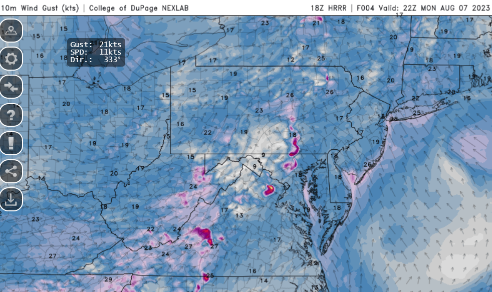
18z HRRR with less wind coverage, but one intense area (67kt). However, per usual, it is running dew points 5 degrees below actual.
-
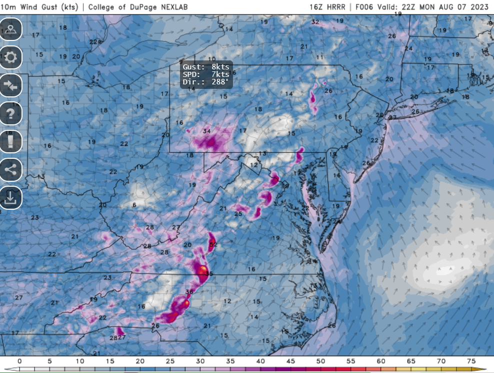
HRRR gusts again 17z. Just seeing how it does with the character of the event.
-
8 minutes ago, Eskimo Joe said:
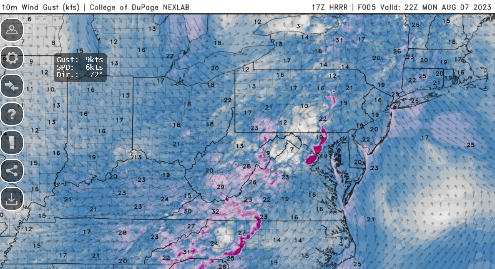
Latest HRRR is pretty underwhelming honestly.
It is favoring distinct bowing segments
-
6
-

August Discobs 2023
in Mid Atlantic
Posted
Over a half inch, which takes me to nearly 11" since July 1st. Quite the turnaround from that dud of a first half of the year.