

MN Transplant
-
Posts
16,380 -
Joined
-
Last visited
Content Type
Profiles
Blogs
Forums
American Weather
Media Demo
Store
Gallery
Posts posted by MN Transplant
-
-
Just got to 90 at home. Looks like the airports are all around 91.
-
 1
1
-
-
Clipped with 0.11” yesterday.
Clouds aren’t a problem this morning. Sterling is being aggressive and going for 100 at DCA.
-
1 minute ago, Eskimo Joe said:
Time sensitive but loop the 0.5 degree base velocity from TDCA. Classic wet mircoburst signature.
Yup, right around 7 corners.
-
9 minutes ago, Terpeast said:
You were right. IAD went higher despite early cloud cover because of the local drought
Hopefully the storms coming that way hold together.
-
Climo report
DCA: 96
BWI: 97
IAD: 98 (tied record)
-
3
-
-
1 hour ago, yoda said:
I think we did
")
I was being facetious, but I am surprised by the difference between my house and the airports. My max is 93.0 today. I’m not usually 5 behind IAD, so that may be the dry soil there helping out.
-
1
-
-
So, do we hit 90 today?
83.9
-
 3
3
-
 1
1
-
-
3 minutes ago, Terpeast said:
Lots of cloudiness that may affect high temps and tstorm chances. I fully expect to get little or no rain, so my only question is whether 98 is too bullish
Euro has corrected down to 96/97. I haven’t been bullish on this heat wave in terms of chances for 100 and I remain that way. It takes a rare airmass for 100.
-
3
-
-
1 hour ago, Eskimo Joe said:
The year without a summer in DC and Baltimore.
I'm thinking 96/97 for all three days at DCA. Just a touch under what NWS is going (98/98/98).
-
1
-
-
4 hours ago, nw baltimore wx said:
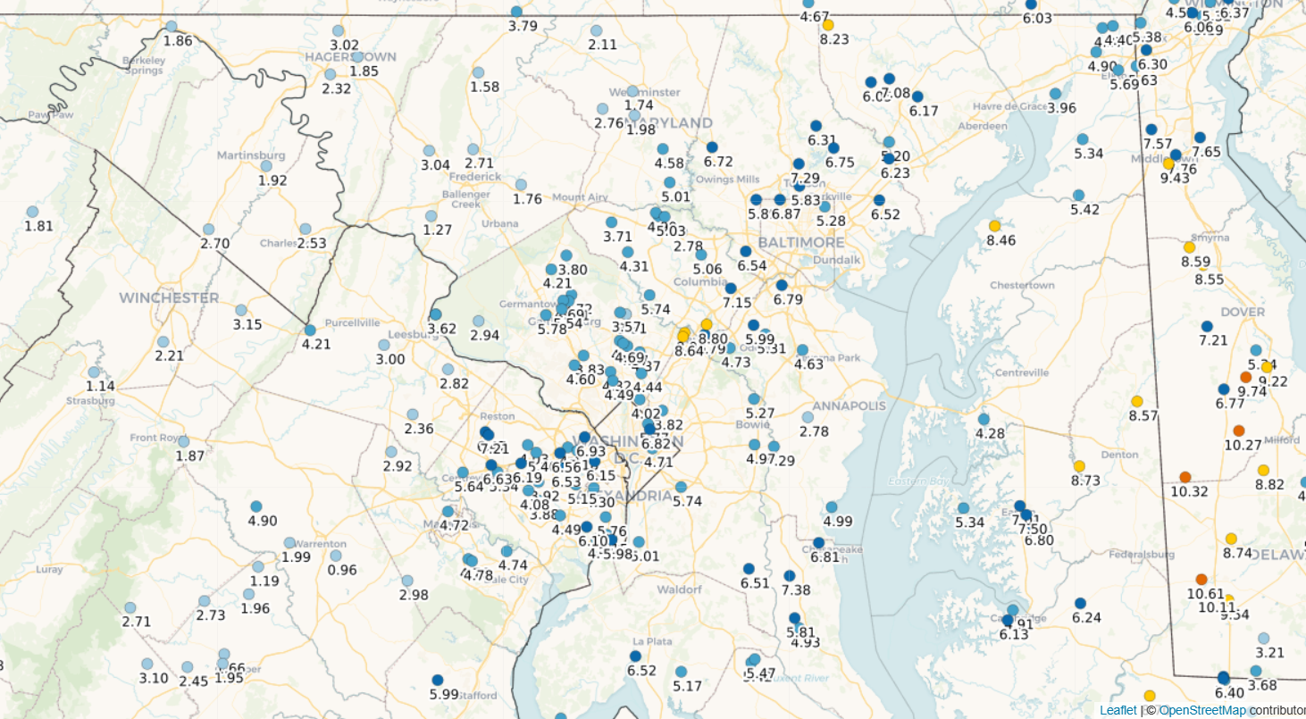
If you have an account, you can do a station report summary. Here’s mine, for example, but you can chart any station.
The custom map does this well. 4" around Burke indeed. The range across our region is amazing.

-
5
-
-
1 minute ago, TSG said:
The big heat the GFS is throwing out for the Midwest next week is downright scary. I can't ever remember such a wide swathe being forecast that far over 100 degrees, for 12+ hours in a single day. Lows in KC Tuesday night would be in the upper 90s...

There has been a discussion elsewhere about the GFS long range having trouble with surface temps because it is drying out the surface too quickly and the boundary layer schemes are having a hard time as it goes further into the forecast period.
I'm skeptical that KC mixes to 600mbs and goes superadiabatic near the surface.
-
1
-
 1
1
-
-
1 hour ago, GramaxRefugee said:
Feb 2015
Avg low of 15 at IAD.
ETA: Well OK, here it is, since there seems to be some interest.:
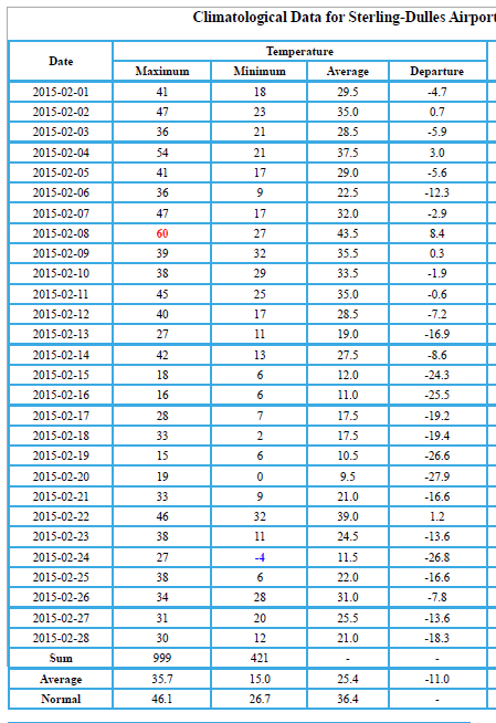
That was a good one. Coldest month at IAD since Feb 1979.
-
2
-
-
19 minutes ago, George BM said:
Wonder if this is of of those heatwaves where IAD and BWI both hit 100F while DCA falls just short.
My contest entry depends on DCA underperforming. Feeling pretty good with the IAD drought and the BWI pavement.
-
3
-
-
8 minutes ago, AmericanWxFreak said:
Warned cluster getting going south of Purcellville.
Kudos to the meso models, they had this 2nd round
-
1
-
-
Radar estimates look like a nice hit in the dry spots in central MD
-
8
-
1
-
-
7 hours ago, nj2va said:
Considering our average high is 89-90, this summer has been mild. Even when we're in the low 90s, that's only a few degrees higher than normal. Our summers have been way more tame here lately. They seemed hotter back in the 2010s.
2010-2012 really skewed what the perception of hot is. For example, 100s are really uncommon, and are often clustered. So every year has less than a 20% chance of hitting that mark.
-
2
-
-
8 hours ago, Terpeast said:
Also I haven’t seen anyone mention the Feb 2006 storm. We may not have gotten the sheer accumulations like 96, 10, and 16, but it was memorable in that I stayed up all night to watch the storm unfold. Rates were awesome. Near whiteout conditions at the height of the storm
This is where I again complain that we got 8” of snow near the Pentagon and it immediately started melting when the sun came up. That one actually ends up on my dud list.
Now Feb 2014 had some rates in the overnight hours.
-
7 hours ago, psv88 said:
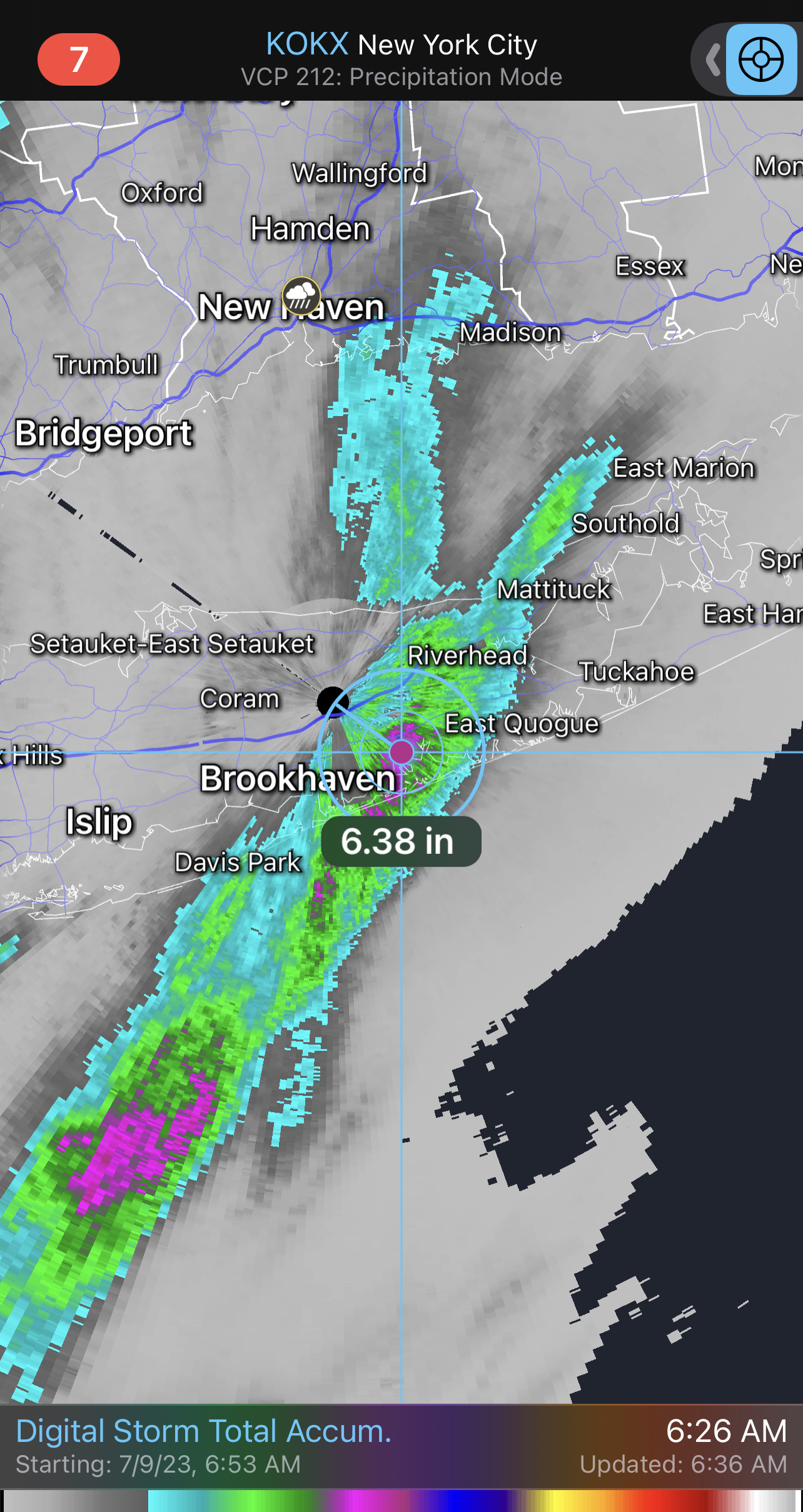
5-7 inches for Long Island is comical.
7 hours ago, psv88 said:5-7 inches of rain!!! What are they smoking?!?

-
9
-
1
-
3
-
-
Quite the event up in PA and NY. Some radar estimates of 10”+ in PA and West Point in NY got 7” in 3 hours.
-
2
-
-
2 hours ago, WEATHER53 said:
So IAD 0.7 then DCA. 0.14 then BWI 1.35”
Following this one time would not mean much but I see it 30 times per year starting about 15 years ago when ethanol became so prevalentModerate to the west, weakens right around DC beltway circle, restrengthens when moving east and north . It’s most prevalent in summer and winter and not fall or spring. A unified cold front in the summer is not so effected.
Just make scrupulous observations from now thru end of February and get back to me.
You should easily be able to prove that with precipitation totals.
-
10 minutes ago, WEATHER53 said:
Anecdotal kinda useless.
Yet another heavy solid rain mass approached DC beltway and immediately decreased in intensity
Hell from PA to Richmond the DC metro took the lightest hit. Sometimes you just have to observe for a long period of time and multiple events and formulate an opinion rather than defaulting to textbook “oh that can’t be so”
Also could be called confirmation bias where you only remember the cases that fit your ideas. The better dynamics were always north today. Fredericksburg is missing out too, but isn’t in the DC beltway.
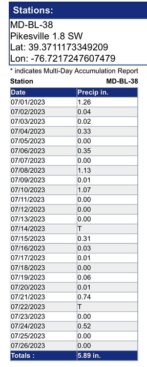
0.14” of pedestrian rainfall today pushing my total to 3.64” for July.
-
1
-
-
6 minutes ago, WEATHER53 said:
More and more does the corn dust circle around DC proper display itself
pouring just started in Kemp Mill
The inside the DC beltway areas have been hit pretty well this week. It just isn’t happening today.
-
1
-
-
3 minutes ago, mattie g said:
This is looking to be lame in the end IMBY.
poo.
The writing on the wall for anything interesting was a couple of days ago. The line near Dulles is now kicking out an outflow boundary, so we'll see where that takes us.
-
2 minutes ago, Terpeast said:
Looks like a split between MD north and central VA south as per radar evolution…
This was a PA show all along, with some northern MD areas also cashing in.

July Discobs 2023
in Mid Atlantic
Posted
We had so many of these kinds of days in 2010-12. Probably as our penance for the 2009-10 winter.