

MN Transplant
-
Posts
16,377 -
Joined
-
Last visited
Content Type
Profiles
Blogs
Forums
American Weather
Media Demo
Store
Gallery
Posts posted by MN Transplant
-
-
20 minutes ago, psuhoffman said:
This happens after almost every big storm I can remember. Some might have a handful of cold days before the warm up…but invariably it warms, whether it’s the day after or 5 days, and everyone acts shocked how fast the snow melts. But fact is 20” will get obliterated FAST as soon as dews gets above 40 and that happens here regularly so it’s almost impossible for the DC area to get snowcover to last long no matter how big the storm.
Periods of 5+ days with at least 6" of snow on the ground at DCA (modern era)
- 1958 (Feb 16-20, max 14")
- 1961 (Jan 27-31, Max 9"), (Feb 9-14, Max 10") - 17 of 25 days in this stretch
- 1966 (Jan 30-Feb 3, Max 16")
- 1979 (Feb 13-Feb 23, Max 22")
- 1982 (Jan 21-29, Max 10")
- 1983 (Feb 12-16, Max 6") - Highs in the 50s the last two days
- 1987 (Jan 23-Feb 2, Max 18")
- 1996 (Jan 7-17, Max 20")
- 2003 (Feb 16-22, Max 16")
- 2009 (Dec 19-25, Max 16")
- 2010 (Feb 6-20, Max 18")
-
 8
8
-
 3
3
-
Nice 0.74" to break a short dry spell of just over a week.
-
1
-
-
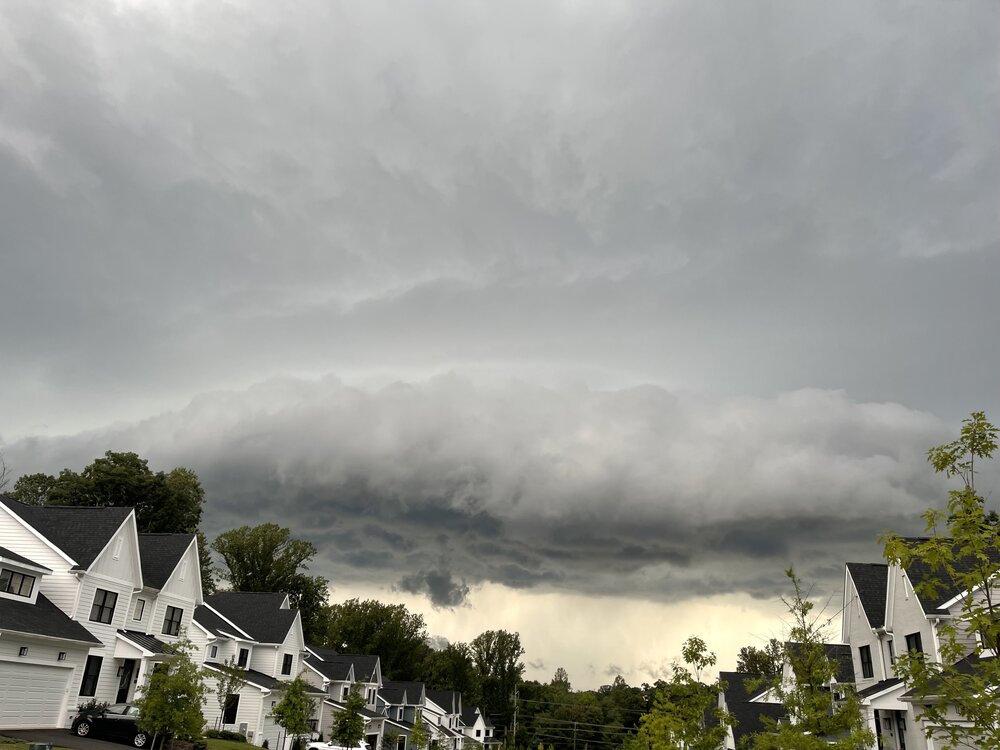
17 minutes ago, MN Transplant said:
Severe warned storm headed towards the DC metro.
-
11
-
-
Severe warned storm headed towards the DC metro.
-
I don’t post in the long range thread because I don’t follow this stuff as closely as you all do, but I have to say that while the globe is clearly warming and things are changing, we are less than 10 years removed from a couple of really cold and pretty snowy winters. Hell, we almost put up a -10 for the month of February 2015. The climate is changing but all is not lost.
-
8
-
-
1 hour ago, stormy said:
Crazy times for the models on Friday afternoon in my immediate region. 102F with 50% cloud cover on GFS at 4 pm. ECM 96F with 25% cloud cover. NAM12 says 67 with rain! Nice!
The only sanity is with the GEM which says 90 degrees with 45% cloud cover.
The GFS has completely fallen apart as far as how deep it is mixing the boundary layer. It has been missing by 10+ degrees from a few hours out in the Midwest heat wave. Ignore the surface temps from the operational runs.
That said, still nasty out there to our west. 100/78 at OHare today.
-
12z Euro trying to home brew. Eastern Gulf storm at 150.
-
1
-
-
90/80 at 11am at OHare. Worse in other parts of the Midwest. All glory to the eastern trough.
-
3
-
-
Hmmm, pass.

Public Information Statement
National Weather Service Twin Cities/Chanhassen MN
305 PM CDT Tue Aug 22 2023

...MAXIMUM HEAT INDEX REPORTS TODAY AS OF 3 PM...

Location                     Heat Idx. Time/Date       Provider
U.s.169 - Mankato - Mp 52    120 F     0225 PM 08/22   MESOWEST
Spring Lake Township         119 F     0251 PM 08/22   MESOWEST
T.h.110 - Inver Grove Hts -  119 F     0230 PM 08/22   MESOWEST
T.h.60 - Madelia - Mp 86     118 F     0220 PM 08/22   MESOWEST
U.s.169 - Henderson - Mp 86  118 F     0220 PM 08/22   MESOWEST
Hanover                      117 F     0250 PM 08/22   MESOWEST
Jordan                       117 F     0251 PM 08/22   MESOWEST
Buffalo AP                   117 F     0255 PM 08/22   AWOS
Corcoran                     116 F     0250 PM 08/22   MESOWEST
Minneapolis                  116 F     0250 PM 08/22   MESOWEST
I-90 - Blue Earth - Mp 119   116 F     0240 PM 08/22   MESOWEST
T.h.19 - Morton - Mp 78      116 F     0250 PM 08/22   MESOWEST
1 W Becker                   115 F     0220 PM 08/22   NDAWN
Rockford                     115 F     0240 PM 08/22   MESOWEST
Eden Prairie AP              115 F     0253 PM 08/22   ASOS
Fairmont AP                  115 F     0156 PM 08/22   AWOS
Princeton AP                 115 F     0255 PM 08/22   AWOS
T.h.7 - New Germany - Mp 161 115 F     0200 PM 08/22   MESOWEST
I-494 - Minnetonka - Mp 18   115 F     0245 PM 08/22   MESOWEST
Carver 3S                    115 F     0249 PM 08/22   RAWS
-
 1
1
-
 1
1
-
 1
1
-
-
1 hour ago, Eskimo Joe said:
I don't think people realize how lucky we are to be average temps with a 597dm ridge over us. We're dodging freight trains here weather wise this year.
It is amazing how we don't even get the rollover heat this year. Bless the eastern trough.
-
2
-
-
7 hours ago, Terpeast said:
The smoke probably suppressed temps today. IAD only made it to 94 with a forecasted high of 97. Mby only 92
I was 88 yesterday, definitely a bust low with the reduced solar input.
-
1 hour ago, Weather Will said:
Anyone know anything about Spire Weather? WB is now partnering with them. You get Basic for free with a WB subscription and pay for more detailed maps.
Spire is a private company who is in the low-earth orbiting satellite game. They are trying to assimilate proprietary satellite data to improve models. They also want to sell their data to NOAA and Congress is on board with the private sector providing data.
-
1
-
1
-
-
3 hours ago, CAPE said:
It's time to start the incremental reseeding/overseeding process. More grass has survived than usual, so it won't be a near complete do over. Normally clover takes over as the grass withers away, but it has not done so this year. The key might be getting 10" of rain in July lol. Normal rainfall never made a difference.
This may be as lively as our grass has looked as we approach late August. Even in the record precip year (2018) there was a short span of no rain in July that torched it. The continuous rain here since late June has done the job.
-
2
-
-
Currently in Florida. Stepped into the Gulf water at Clearwater and it was bath tub. 91.
-
4
-
2
-
-
Really nice out this morning with a breeze and 70/60.
-
2
-
-
4 minutes ago, vastateofmind said:
The latest flash flood warning issued for SE FfxCo is personally interesting...they typically mention the areas/neighborhoods AROUND where I live (e.g., Franconia, Lincolnia, Fort Belvoir, Mount Vernon) but this time they actually included our neighborhood, Hayfield. And we are indeed having a "round two" that is rivaling yesterday afternoon...maybe not horizontal rain, but definitely diagonal, and I can fully believe the 1-3" that NWS says is possible within the next hour.
I can hear your cell grumbling from the western side of the Beltway.
0.11" today, so a miss, but we have done plenty well over the last two months.
-
1
-
-
26 minutes ago, mattie g said:
Wow...lightning strike less than .25 mile outside the home office window. Big flash over my shoulder and then BOOM!
Edit: To say that there's no wind to speak of, but it's now pissing down.
Wild that the main stripe and NW cutoff were in eerily similar positions as yesterday.
-
8 minutes ago, WxWatcher007 said:
What a year of severe
We’ve had a run of later summer severe in the last several years. It is making up for about nothing in Apr/May.
-
1
-
-
2 minutes ago, jbakerman said:
3+ inches of rain from the storm as it passed through Burke, and going. Not surprised it was just warned for tornado, nasty stuff.
Kudos to LWX to hit the Flash Flood Warning early. I was skeptical based on radar, but these are efficient as hell. I’m at 0.61” despite being on the periphery.
-
3
-
-
-
5 minutes ago, southmdwatcher said:
Tornado Warning for Charles County
(Insert La Plata comment here)
-
2
-
 2
2
-
-
25 minutes ago, mattie g said:
Missed us by 5-10 miles. We've definitely missed out a little more than YBY for much of the summer.
At least you aren't west of Dulles.

-
I should have posted this one in here.
-
1
-
2
-
-
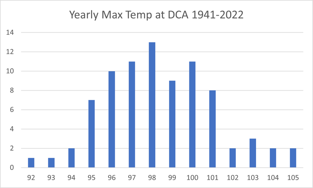
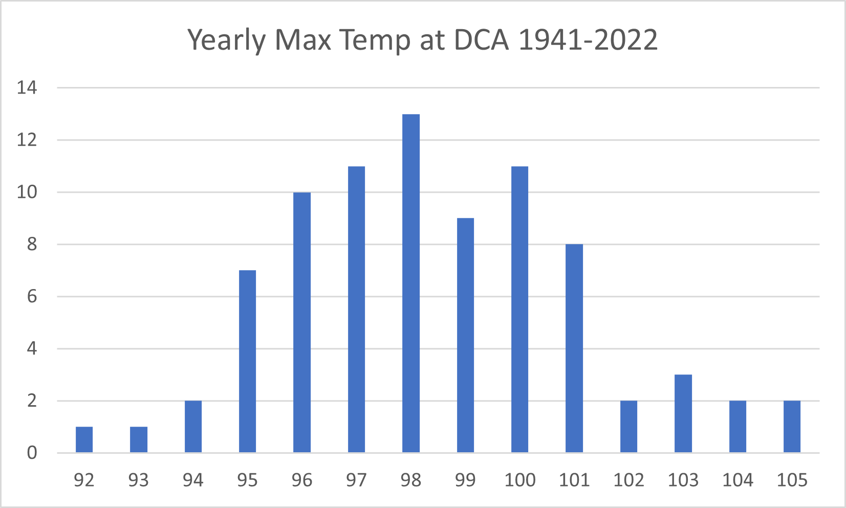
2 hours ago, Eskimo Joe said:
Unless something changes dramatically, it appears that many of us went too high with temperatures for this summer.
People went too high for most summers. It is a minority of years that hit 100.
-
1
-

August Banter 2023
in Mid Atlantic
Posted
It went completely off the deep end maybe 1-2 months ago. There was some discussion about the land surface being a problem, but it looked like it was only in the long range. It wasn’t. My hometown has an all-time high of 107 and it was trying to pump out like 110-113 from a few days out. The reality was 100.