

MN Transplant
-
Posts
17,670 -
Joined
-
Last visited
Content Type
Profiles
Blogs
Forums
American Weather
Media Demo
Store
Gallery
Posts posted by MN Transplant
-
-
38 minutes ago, Eskimo Joe said:
BWI breaks the record.
IAD also. DCA river winded and dropped back into the mid-80s, so unless there is a later wind shift, they may just tie.
-
 1
1
-
-
3 hours ago, MN Transplant said:
We are on record high watch today.
DCA: 89
BWI: 88
IAD: 87
I'm running ahead of the airports right now, already 78.3.
Each of the stations tied the record at the 1pm ob.
89.2 at home.
-
2
-
-
We are on record high watch today.
DCA: 89
BWI: 88
IAD: 87
I'm running ahead of the airports right now, already 78.3.
-
2
-
-
2 hours ago, pazzo83 said:
pretty much perfect - it doesn't get better than this in our region.
Dead on 70.0 for the high at my house.
-
2
-
-
30.4. Lots of 20s on the MD mesonet.
-
6 hours ago, RDM said:
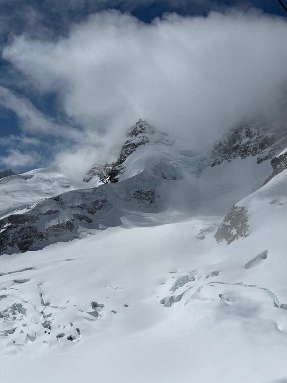
Great shot MN. Zermatt is my old stomping grounds. My family had an exchange student from down in the Rhone Valley near Brig who worked in the Wega souvenir shop near the train station in Zermatt. She's like another sister to me and we've kept in touch for 45+ years. Through her family and friends in Switzerland I was very fortunate to get indoctrinated into the Swiss culture. Her dad used to drove the cog train from Brig/Visp up to Zermatt (part of the famous Glacier Express train route).
First skied the glacier near the Klein Matterhorn in 81 during my first trip to Europe with my parents. Then a few years later lived in Germany for the first of 2 stints there. Skied Zermatt about 20 times, plus Sass Fe, Verbier, Crans Montana, and many other resorts in Switzerland, Germany, Austria and France. Did a fair bit of back-country in the Alps too - I used to only telemark ski but doubt my knees could take it now.
If you had enough snow to ski from the top of the Klein Matterhorn all the way into town, that's about 8500 vertical feet in one run. About the only other place on earth that will match that much vertical in one run is in Chamonix.
Did you have a chance to take the run down the other side into Italy? The run from Plateau Rosa down to Cervina is an awesome run.
We had originally intended to do Zermatt and do the Italy trip that you note, but we were hitting multiple countries and had limited time in Switzerland. We ended up choosing Lauterbrunnen as a base and went up to Jungfraujoch for my high-altitude fix. The Eiger Express aerial tram is a smooth piece of engineering. Still hope to do northern Italy and the Matterhorn at some point in my life.
-
1
-
-
9 hours ago, Jebman said:
I'd be so happy, in fact I'd be so REBORN from the April Fools Blizzard of 2026 in Washington, DC with 39 inches of fresh snow, that I'd fly in on a red-eye just for the occasion.
Special for you, the mountains of Switzerland. Amazing up here.
-
14
-
 1
1
-
-
22 minutes ago, TSSN+ said:
Can’t wait to pay over 5 dollars a gallon for gas… this is getting ridiculous
I just filled up a small SUV in Germany for $120. Cost of travel and all, but ouch.
-
1
-
-
Checking in from abroad to see that I got 0.01” at home yesterday, which tracks.
-
1
-
 1
1
-
-
B+. A blockbuster winter storm followed by about as cold of a streak as we can muster. Just a shame it didn’t snow more.
-
2
-
-
4 hours ago, WxUSAF said:
Will have the latest bloom of our saucer magnolia in the 11 springs we’ve been in the house. By at least 2 weeks. Maybe more.
The stuff in my yard is late, but curiously the cherry blossoms at the Tidal Basin are only slightly behind normal. Extension of Florets was March 16. In 2015 it was Apr 4!
-
1 minute ago, wxmeddler said:
Fun...
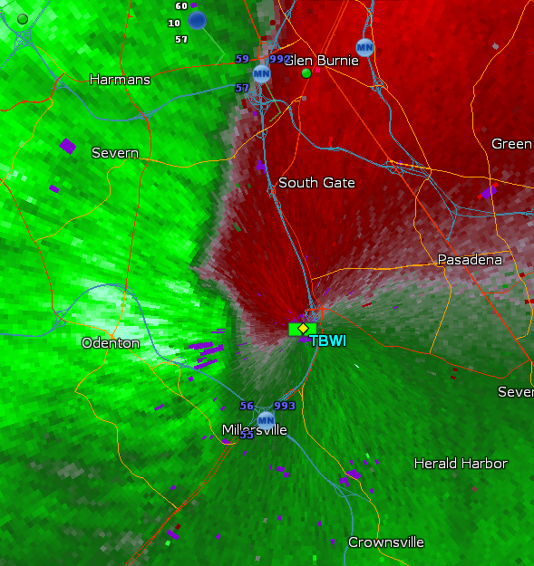
We are so lucky to have 4 radars
-
Outage numbers aren’t huge, but they are climbing. Dominion VA is up to 95k, with Stafford county as the hardest hit in northern-ish VA.
-
1
-
-
1 minute ago, zwyts said:
This was always the main event right? why were people so focused on this afternoon.
There was too much play on the tornado aspect and not enough on the forced line this evening.
-
3
-
 1
1
-
-
To nobody’s surprise, there are no flights coming into DCA or BWI right now. One sad flight from Houston is making circles south of Dulles.
-
 1
1
-
-
-
I think there are transformers blowing in Tysons
-
 1
1
-
1
-
-
Severe warning everything from central MD on south
-
6 hours ago, aldie 22 said:
Man Green Bay has received a ton of snow...I hate that fucking town
Bunch of 30”+ reports in that region. Blockbuster storm for them.
-
2
-
1
-
-
It is pouring in waves. Instant rain rate of >6"/hr.
-
7
-
-
It is snowing in Birmingham, AL. This is quite the system.
-
7
-
 1
1
-
-
Those cells passing just east of CHO need to be watched
-
Would not surprise me at all if there was a brief touchdown just after it crossed the Potomac. TIAD had a great view of that one.
-
1
-
-
2 minutes ago, Eskimo Joe said:
Sun out in Rockville. Visible satellite showing some legit breaks in the clouds.
DCA and IAD have officially gone over to Broken from Overcast. I'm up over 200 w/m2 solar like some of the mesonet sites.
-
6
-
April 2026 Medium/ Long Range
in Mid Atlantic
Posted
Yeah, on the HRRR and NAM 3k everyone gets something, but the lower totals are around 0.05".