

MN Transplant
-
Posts
17,196 -
Joined
-
Last visited
Content Type
Profiles
Blogs
Forums
American Weather
Media Demo
Store
Gallery
Posts posted by MN Transplant
-
-
5 minutes ago, pazzo83 said:
probably 99F (with 4 straight 5-min obs of 98.6F / 37C). We'll see!
Need the wind to kick off of Crystal City
-
 2
2
-
-
DCA probably 98. Reminder that 99 on the 5-min obs could be 98 or 99. 100 is 100.
I’m up to 97.5
-
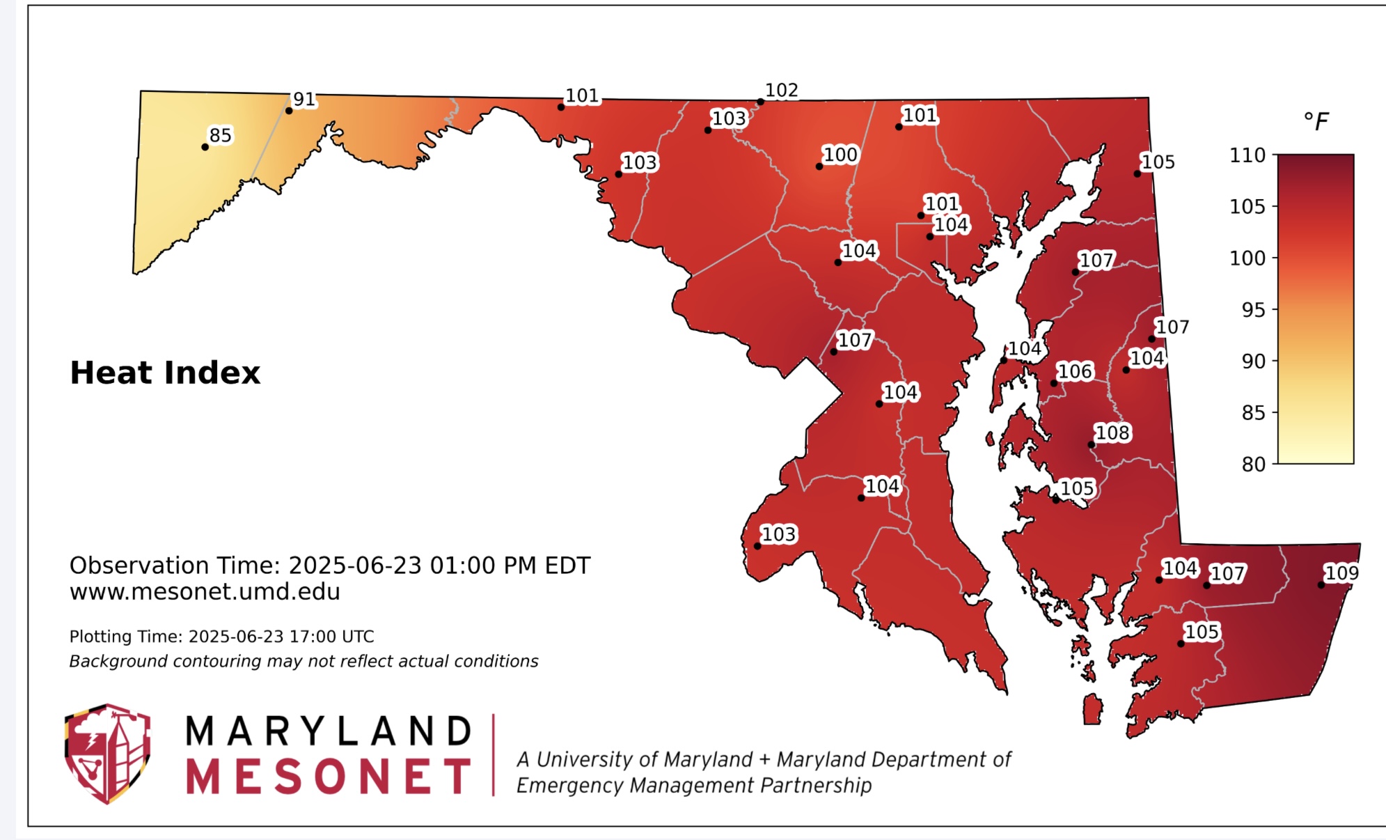
The MD mesonet shows a good correlation between temps and sail moisture. The Salisbury area is dry and temps continue to run a couple of degrees warmer there. That’s why I’m still skeptical of hitting 100 this week.
-
1
-
-
93.0. Staying inside all day.
-
Highs:
98 at DCA (99 was the record, way back in 2024)
97 at BWI (1 short of 2024’s record)
96 at IAD (2 short of 2024’s record)
Remember kids, always ignore the Euro surface temps in summer.
-
 4
4
-
 1
1
-
-
-
106 HI at DCA
-
2
-
-
DCA at 92, running +8 over the river wind of yesterday.
That 500 height number is close to the dreaded 600dm level.
-
21 minutes ago, yoda said:
9am
DCA 84
IAD 86
BWI 88
Inner Harbor/Science Center is 93 lol
DCA hopped from that 84 to a 89/90 reading 13 minutes later. Looks like we already have widespread 90s at 9:30am.
-
1
-
-
91 DCA
93 BWI
94 IAD
-
Before this starts, on the Global side, the ICON is the coolest and shuts the big heat down earliest, while the Euro is still insisting on topping 100. GFS in the middle with upper 90s but pushes any relief well down the line.
The mesos have a similar spread, with the NAM Nest on the low side with mid-90s and the Canadians into the 100s. HRRR has upper 90s to near 100 Monday.
-
3
-
 1
1
-
-
I’m trying to determine what is the grossest part of the 18z parent NAM run, and I think it is the 108 Heat Index at 8pm on Monday.
-
 2
2
-
-
5.08” for the week. Almost 14” since May 1st. Less than an inch behind 2018 for the wettest May-June combo in my 11-year record.
-
2
-
-
1 hour ago, Eskimo Joe said:
18z RAOB from IAD told the tale, plenty of surface CAPE and low level lapse rates, but absolutely pitiful mid level lapse rates and no shear. Had we better timing, this would've been a legit event for everyone.
You could see that it gusted out in MD while it didn’t in VA. We had no outflow boundary.
-
Almost 100k w/o power in northern VA
-
1
-
 1
1
-
-
DCA to 61mph
-
3
-
1
-
-
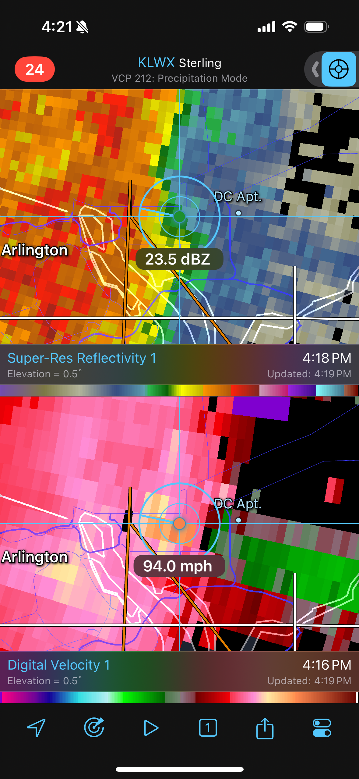
2 minutes ago, NorthArlington101 said:

There’s some radar interference along that line. Look at the returns stretching to the ESE. I’d toss that reading.
-
1
-
-
Good solid knock of wind at the start. Easily could have been in the 50s.
-
2
-
-
57kts IAD
-
4
-
1
-
-
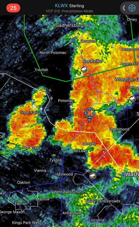
7 minutes ago, caviman2201 said:
on the sim reflectivity? maybe i'm looking too hard for it... I was expecting to see it actually model the little 'ring' of outflow reflectivity like you can see in real radar scans
Check out the CAPE Loop.
-
2
-
1
-
-
You can see on the 12z HRRR how an initial cell kicks off an outflow boundary and then new cells fire on that this afternoon. Not saying that’s exactly what will happen, but it is cool to see those processes on the models.
-
3
-
-
We have had weeks with more precipitation than this, but I cannot remember a time where everything has been wet for nearly a week straight. At no point since Friday could I have mowed the lawn or sat on a chair outside without wiping it off. Maybe 2018?
-
2
-
-
16 minutes ago, aldie 22 said:
You ok now lol
It is amazing how it generally evens out over time
-
1
-
1
-
-
This is a miserable trip
June Discobs 2025
in Mid Atlantic
Posted
I’m going to top out at 97.9.
Put this ridge over us in mid-late July and we’d be in 2011 territory.