

MN Transplant
-
Posts
16,385 -
Joined
-
Last visited
Content Type
Profiles
Blogs
Forums
American Weather
Media Demo
Store
Gallery
Posts posted by MN Transplant
-
-
41 minutes ago, WxUSAF said:
Fingers crossed!!
5 Ks through 3 with no guys past second base. On pace!
-
8 hours ago, WxUSAF said:
Woof. Glad I didn’t stay up and watch the O’s last night.
I was bummed I didn't make the trip up! Don't worry, the Twins will strike out 15 times this afternoon and not get a guy beyond 2nd base.
-
Ha, stick save
-
 3
3
-
 1
1
-
-
43 minutes ago, nw baltimore wx said:
For the CoCoRaHS users, I’m including todays rainfall in June for reporting purposes.
So, you are backdating it to this morning's report?
-
Nothing. Air quality improved a touch.
-
 1
1
-
-
82.5 mph on this station near Indianola, IL: https://ambientweather.net/dashboard/b30b4bfc5287a664831e9627778376be/tiles
-
16 minutes ago, Maestrobjwa said:
And I don't get that...aren't upgrades supposed make stuff, well...better? Lol Why do some model upgrades seem to make things worse?
The problem with complex, interconnect models like these are that you can’t just simply “fix” one thing and make it better. Let’s say you increase the resolution. While there are huge benefits to that, there are also potential downsides because every weather model has estimates built in and those may not be valid anymore at a different resolution.
It also depends on what is being verified. The modeling centers run and assess for quite a while before release. But if they are focused on, say, heights and temperature, they may not care as much if east coast cyclones are now not handled quite as well.
-
5
-
-
16 minutes ago, vastateofmind said:
Thx for sharing...that's a very usable tool, as good as PurpleAir's map (maybe even a bit easier).
I wish there was a middle ground where the map starts off as just dots, which looks cleaner, and then as you zoom in you can see the numbers. PurpleAir and Paku both show the values all the time while this one doesn’t show them at all. CoCoRaHS got it right with their interactive precip map.
-
1
-
-
I thought it smelled more yesterday but the 2.5 levels are a bit higher today. Should diminish starting tomorrow as we go to a south wind.
-
6 hours ago, Eskimo Joe said:
Happy derecho anniversary!
Tomorrow!
-
 1
1
-
-
Brutal difference between west and east of Baltimore month-to-date.

-
2
-
-
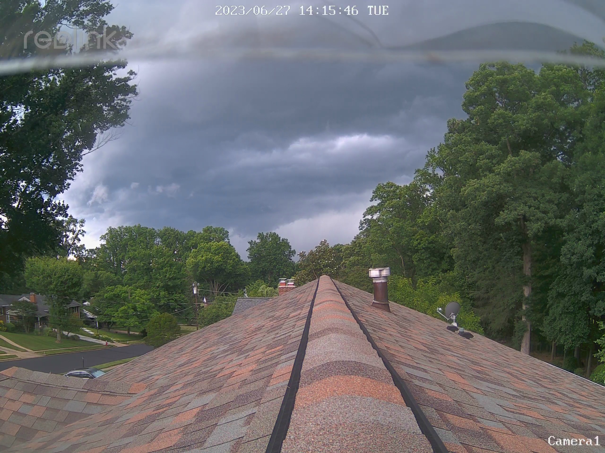
1 hour ago, Terpeast said:
My mom's house in FXCo is getting hammered now
Heard from a co-worker in Oakton that they had a "wicked" storm. He's from Long Island, not Boston, but still.
-
3 minutes ago, WeatherShak said:
Temp dropped 10 degreesDown almost 20 from the high and at the low of the day, 65.7.
0.13", so not a ton of rain.
-
I had an outflow gust in the 30s, but nothing once the rain got here.
-
-
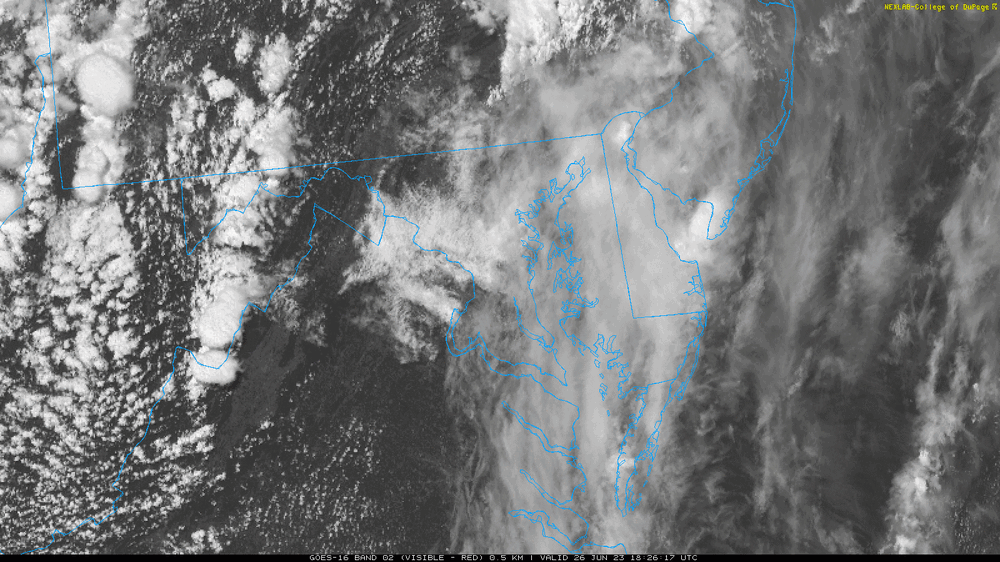
14 minutes ago, csnavywx said:

Meh, mostly a bust for our area. Cells struggled as they came off high terrain over N Va and most of MD. Needed a bit more BL moisture to avoid it being partially mixed out in the PM hours. Where that was available, they did pretty well.
Ironically, we'll probably get better storm coverage today with higher quality BL moisture and direct forcing from the upper trough. Shear is light, so shorter-lived multicells only.
It is interesting that there were several "gaps". It wasn't only DC, but the VA/NC border, the NC/SC border, and NE PA. These are things that are just simply unpredictable at this point.
-
2
-
-
3 hours ago, yoda said:
I'll put this here
The good news is that when ECMWF pushes the envelope, Congress pays attention.
-
3
-
-
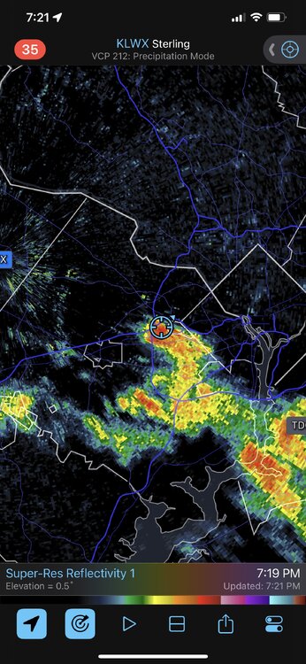
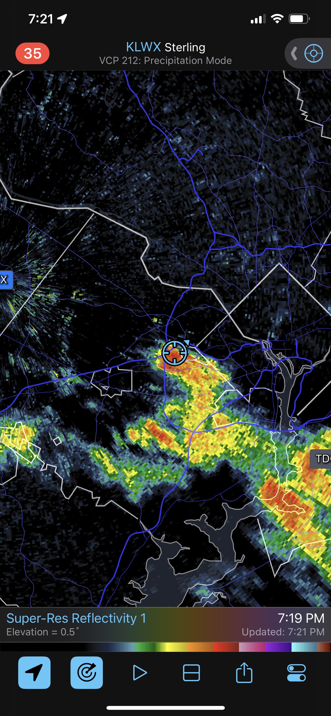
Just now, kgottwald said:
From an upper floor of a Tysons Corner office building, I can see a heavy rain shower over Mongomery County.
Looks like that one just started producing lightning.
-
12 minutes ago, Moosey2323 said:
Will this big cirrus shield (that one of the first cells formed) inhibit convection in northern Virginia?
Possibly, but it is unlikely to be significant in this case. Research has found that large, slow-moving MCSs have more impact.
-
1
-
-
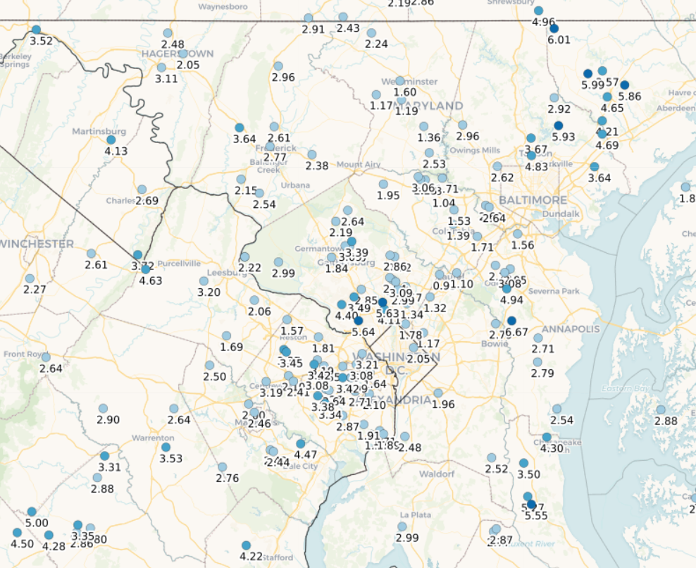
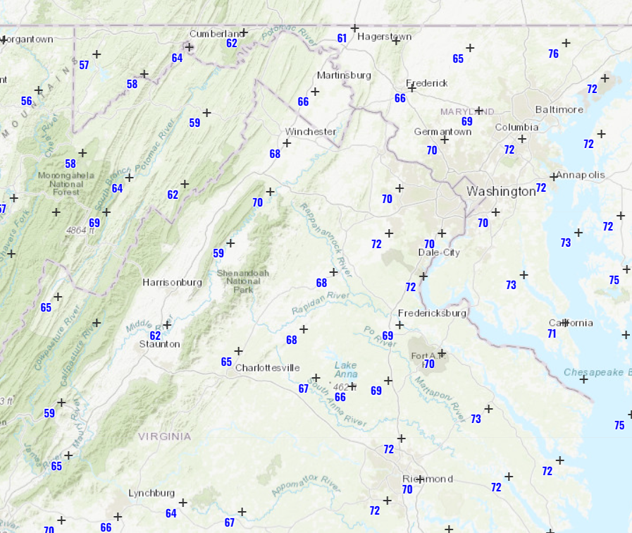
Maybe the most encouraging ob is the 68 degree DP out in Winchester.

-
2
-
-
9 minutes ago, Eskimo Joe said:
Socked in with clouds. Don't see how realize any potential today north of I-66.
There is a realistic fail mode here that has been hinted at by some models where there are good storms up in PA where the dynamics are solid and down in southern VA and NC where the instability is better.
-
2
-
-
Paying attention to the DPs on the HRRR vs NAM. HRRR is much drier and the coverage is unimpressive. Is that a bias in convective scenarios this year? I haven’t been paying attention.
-
1
-
-
1 hour ago, yoda said:
00z HRRR at range of course, but that's pretty nice looking radar forecast from hours 43-48
Wouldn't mind the 00z NAM NEST or the 00z FV3 either
00z NAM Nest looks good for severe. Always an IMBY game though.
-
1
-
-
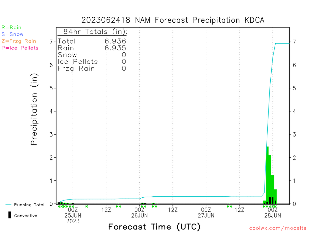
18z NAMing. 7” in DC
-
2
-


July Banter 2023
in Mid Atlantic
Posted
1 run with 12 Ks for the Twins. We’ll see Duran vs the top of the Os lineup. The Twins do have one of the best pitching staffs in the league. The hitting, not so good.