

MN Transplant
-
Posts
17,197 -
Joined
-
Last visited
Content Type
Profiles
Blogs
Forums
American Weather
Media Demo
Store
Gallery
Posts posted by MN Transplant
-
-
Might sneak in a 90 today
-
2.36” total. Not exciting, but sorely needed.
-
 3
3
-
-
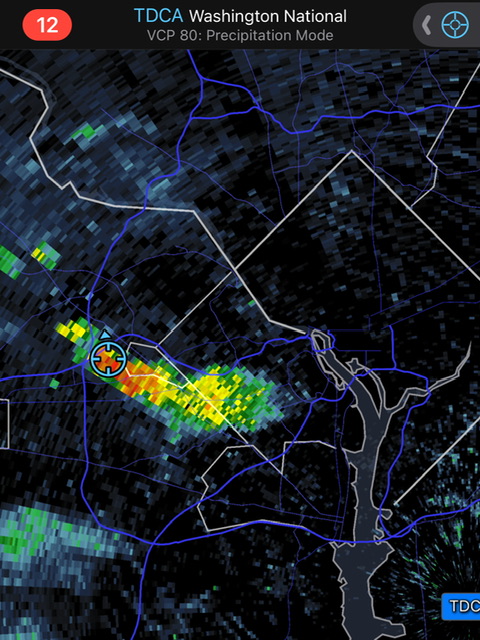
Over an inch in 30 min at DCA
edit - two different periods of >0.25” in 5 minutes
-
1
-
-
3 minutes ago, H2O said:
For those that remember, people east of I-95 this will be very much like TS Lee. Training bands will drop a lot of water over the same places.
Lee was the best. These bands are more progressive though, so heavy rain, but not hours upon hours of it.
-
1
-
-
3 minutes ago, LP08 said:
That firehose is set up right over you and just west of me. More to the south too.
looks better on velocity than the earlier one.
Under it now, but there’s nothing other than heavy rain
-
1
-
-
3 minutes ago, LP08 said:
Spinning again down near Springfield.
I have my eye on that one. That’ll be close to my house.
-
Briefly considered trying to “chase” that Beltway storm, but it never looked that great. Appreciating the rain train, though.
-
Tor war on the cell just E of Rockville
-
1
-
-
Hoping that stuff SE of Richmond keeps a more northerly path. ~0.90 total event so far.
-
General reminder that inland TC tornadoes are highly diurnal
-
2
-
 2
2
-
-
0.71”. This has been a fine August so far. Just wish it wasn’t coming off a dreadful Jun/Jul.
I’d prefer the 5” that the RGEM gives me the rest of the way, rather than the <1” on the HRRR and NAM.
-
2
-
-
Airports so far
BWI: 0.20”
DCA: T
IAD: zilch
-
6 minutes ago, StormyClearweather said:
FWIW, 0Z HRRR looks pretty significantly east than the 18Z, though still plenty west to keep the folks who really need rain in on the game.
Still, brutal cutoff. Verbatim, less than 0.5” at DCA.
-
Mwahahaha. I will take my tiny cell.
-
6
-
-
I think a lot of us E of 81 are going to be looking at the pre-game action today and tomorrow. The HRRR is really aggressive on that, with the NAM less widespread but still with heavy pockets.
-
1
-
-
18 minutes ago, WxUSAF said:
East side is definitely more variable. But 3k NAM is not a tropical model…
Yeah, but the HAFS look even worse, so I’m trying to ignore them.
-
1 hour ago, Eskimo Joe said:
Euro on an island. Yea I smell bust.
I’m not on the doom train yet, but I think we have to be realistic that on the east side of the circulation there will be training cells that put some in the winner’s category and leave others with a more moderate result.
-
16
-
-
1 hour ago, WxUSAF said:
Wow, storms evaporated on my doorstep last night. 0.01” lol
You beat me
-
 3
3
-
-
11 minutes ago, WxUSAF said:
That line of storms between the other two area of storms ripped open like a zipper in minutes. Very cool radar presentation. Think DC-north gets some nocturnal action (hi RR).
Yeah, that was cool
-
18z NAM Nest says I get more rain in 6 hours from 00z to 06z Friday (~2.5") than the 18z GFS run through Saturday (<2").
-
1
-
1
-
2
-
-
Another 95 at home, making it the 23rd occurrence of 2024.
-
2
-
 1
1
-
-
It is thick out there this morning. DPs in the mid-70s. Gross.
-
1
-
-
Sitting at 3.10" for the summer. I could get 5" of rain this week and still be at the lowest summer-to-date total in my 10 years of CoCoRahs obs.
-
5
-
-
The broad brush of the models is similar. Misses the Tues/Wed shallow trough and meanders near the GA/SC coast and then interacts with the second trough later in the week which pulls it north. How exactly it interacts with the second trough and how deep the trough digs affects our chances for heavy rain. The Euro is risky because it is a very shallow trough that shunts the storm off before it is able to climb too much. Obviously the ICON is on the opposite side.
-
6
-
August Discobs 2024
in Mid Atlantic
Posted
Showers popping S of 66