MN Transplant
-
Posts
17,625 -
Joined
-
Last visited
Content Type
Profiles
Blogs
Forums
American Weather
Media Demo
Store
Gallery
Everything posted by MN Transplant
-
It is fun to crap on Kirk, but he led game-winning type drives in both games this season, only to see his star RB “fumble” (air quotes because the booth f-d up the review) and his kicker miss.
-
Those dew points.
-
2021 Atlantic Hurricane Season Tracking Thread
MN Transplant replied to WxWatcher007's topic in Mid Atlantic
Got it. "Peak season" was throwing me off. -
2021 Atlantic Hurricane Season Tracking Thread
MN Transplant replied to WxWatcher007's topic in Mid Atlantic
Ok, there are too many pages. What are these numbers? Is that a full-year forecast, or a forecast-to-date? What does the () refer to? -
Euro has the frontal passage on Thursday. GFS Wednesday. Go USA!
-
Radar totals seem to be matching ground truth. Near 3” in an hour in Annandale inside the Beltway and by Inova Fairfax hospital. Only about a half inch here.
-
2007 Mote, T.L., M.C. Lacke, and J.M. Shepherd, 2007: Radar signatures of the urban effect on precipitation distribution: A case study for Atlanta, Georgia. Geophysical Research Letters. 34. L20710, doi:10.1029/2007GL031903. You can probably trace from Marshall Shepherd’s work to get to what is most interesting to you.
-
Got the alert for a flash flood emergency.
-
Plenty have tried. There are papers about it, but differentiating all the aspects is difficult.
-
FF Watch. Looking at radar, I don’t see any way that the UHI over DC didn’t contribute to initiation.
-
That's the service you get when you try to gut an essential organization.
-
Hard to tell from a still image. "Clear air" echoes can be a variety of things, with bugs probably being the top culprit. The radar wavelength that the NWS radar are at (S-band, 10cm) are also sensitive to Bragg scattering from atmospheric eddies. At times, the radar beam can also be reflected back to the surface (anomalous propagation).
-
2021 Mid-Atlantic Garden, Lawn, and Other Green Stuff Thread
MN Transplant replied to mattie g's topic in Mid Atlantic
They seem really loud this year, but I can’t tell whether I’m just hyper-sensitive to them now. -
2021 Atlantic Hurricane Season Tracking Thread
MN Transplant replied to WxWatcher007's topic in Mid Atlantic
Larry is going to rack up some ACE. -
I’m guessing there are no new posts on this forum since everyone is outside.
-
Great Falls from the VA side this evening. I’ve never visited while the water was up, so this is impressive. Amazing that the flood markers are in a different stratosphere.

-
There’s another video out there of a guy walking through ankle deep water and then as soon as he goes to another room, the wall gives out and the whole room immediately floods. In this case he was ok, but that’s the scenario where it can happen very quickly. found it -
-
The models did really well. That is an exceptional match, though.
-
I’m not suggesting they drive ahead, just point the cab over to the shoulder. Truck drivers are very experienced with the dangers of cross-winds.
-
Come on. Get away from the power lines and try to get as parallel to the wind as possible.
-
I do think that it is a bit of a damned-if-you-do, damned-if-you-don’t situation for the administration. We all generally had the same forecast. If they had shut down school in Fairfax County and then we got less than an inch of rain and no wind during the day (which is what happened), parents would be pissed that they canceled school for a bit of rain.
-
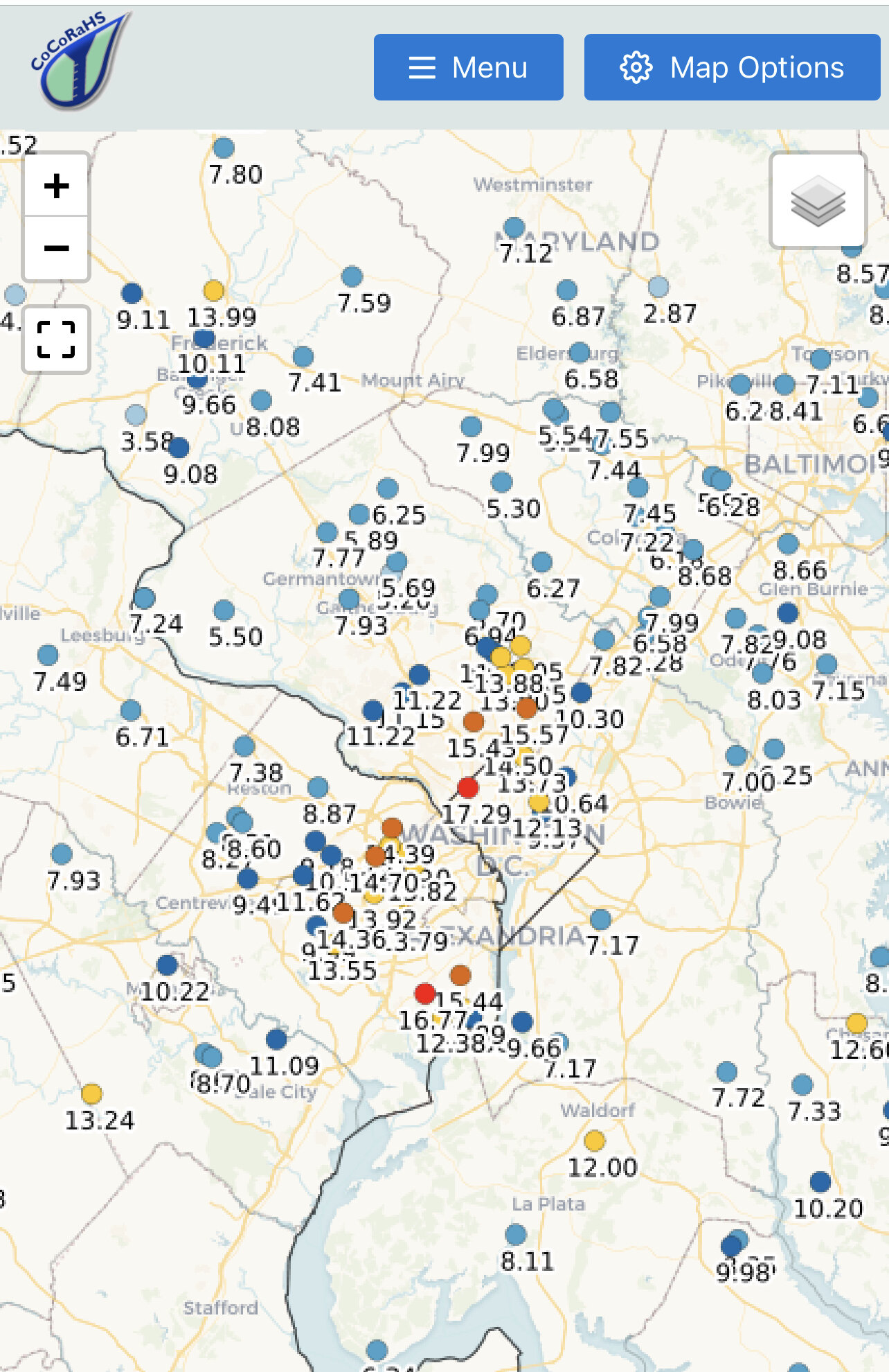
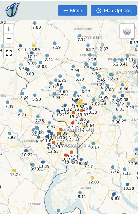
DC Beltway bullseye over the past six weeks.
-
This is how we know that summer is over.
-
1.98” from the overnight cell and another 0.90” during the day yesterday.
-
Still raining!