MN Transplant
-
Posts
17,845 -
Joined
-
Last visited
Content Type
Profiles
Blogs
Forums
American Weather
Media Demo
Store
Gallery
Everything posted by MN Transplant
-
January 16-17, 2022 MLK storm obs/now cast
MN Transplant replied to George BM's topic in Mid Atlantic
2.2" in Falls Church and coming down nicely. Temp has moved up, but still only 25.7. -
January 16-17, 2022 MLK storm obs/now cast
MN Transplant replied to George BM's topic in Mid Atlantic
Bigger flakes. Grass starting to get covered. -
January 16-17, 2022 MLK storm obs/now cast
MN Transplant replied to George BM's topic in Mid Atlantic
0.7” on the first measurement. 22.6 -
January 16-17, 2022 MLK storm obs/now cast
MN Transplant replied to George BM's topic in Mid Atlantic
Temp has dropped from 24.4 to 22.8 over the last hour. Nice coating to start. Dud of a football game though. -
January 16-17, 2022 MLK storm obs/now cast
MN Transplant replied to George BM's topic in Mid Atlantic
I recorded 980mb (28.94") on 2/7/2020. -
Some comedy from the northern VA subreddit. There were a lot of people doubting that it would snow earlier this month because of surface temps.
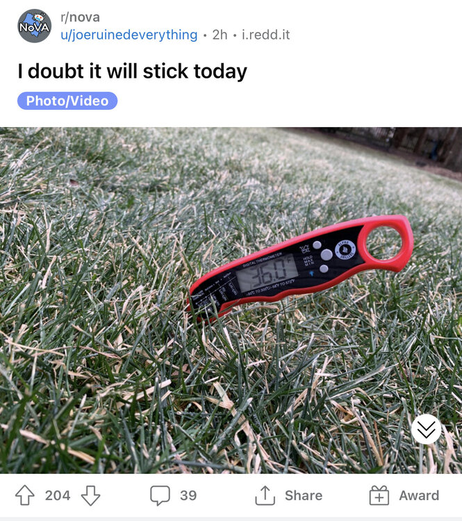
-
January 16-17, 2022 MLK storm obs/now cast
MN Transplant replied to George BM's topic in Mid Atlantic
It isn't. The automated algorithm clearly is struggling there. -
January 16-17, 2022 MLK storm obs/now cast
MN Transplant replied to George BM's topic in Mid Atlantic
The front end frozen on the HRRR looks decent, but it has also been pumping the temperatures on the back side of the precip shield. Now nearly 50 degree rain at DCA at midnight. -
January 16-17, 2022 MLK storm obs/now cast
MN Transplant replied to George BM's topic in Mid Atlantic
You can see some flakes on the traffic cams just south of Richmond and steadier, but still very light, snow around Petersburg. 14Z HRRR has effectively held its ground. -
January 16-17, 2022 MLK storm obs/now cast
MN Transplant replied to George BM's topic in Mid Atlantic
Oh, NAM. 12z is snow through ~6pm with about 0.3" precip in DC and frozen through ~8pm with another 0.2". So, not only a later changeover, but more precip early. And in Minnesota - Climax is very close to Fertile and up the road from Moorhead. So, yeah. -
My wife grew up on a 200 acre campground (her parents maintained the place for church camps, yes, they were quite poor). She has always wanted to own some land and have a place to retreat to and potentially retire to. I totally get it, and I could have a blast wandering around a big property and doing all sorts of projects. However, I am a suburban kid and that's where I have always been comfortable. I just can't wrap my head around being long distances from major hospitals, not having a ton of grocery and shopping options nearby, and the other things that come with rural living. But one thing seems to bother me more than all the rest - the internet situation. I don't know what the future holds for Starlink or other satellite providers, but the lack of good broadband in many places that do have available land is just a killer. Hopefully you can find a good spot!
-
January 16-17, 2022 MLK storm obs/now cast
MN Transplant replied to George BM's topic in Mid Atlantic
14.5 for the low. Coldest since the single digit temps of late Jan 2019. -
January 16-17, 2022 MLK storm obs/now cast
MN Transplant replied to George BM's topic in Mid Atlantic
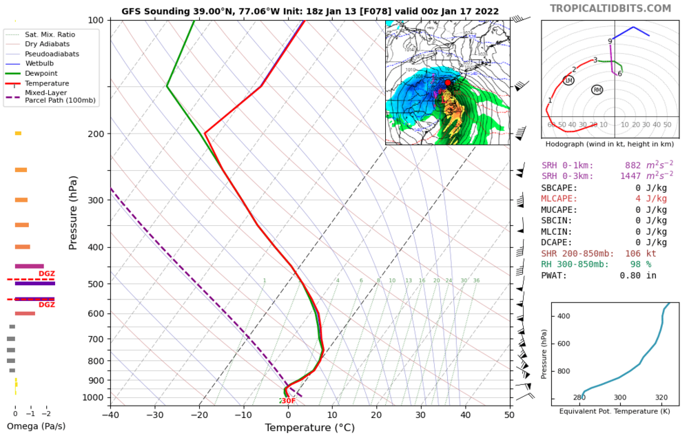
Comparing to the 06z HRRR, the frozen precip totals are very similar, but the HRRR hangs on to snow for an hour longer, so the snow totals are more like 2” with a bit of IP/ZR on top. By the way, for the Winchester area folks, ignore the NAM nest precip totals. The NAM is too aggressive with topographic lifting. There is still a 800mb warm nose that is problematic, but you should get more precipitation than the nest shows. Hopefully the HRRR pans out. -
January 16-17, 2022 MLK storm obs/now cast
MN Transplant replied to George BM's topic in Mid Atlantic
I’ll leave the snowfall map to others, but the 06z NAM nest is similar to prior. Lose the column at 5pm after 0.15” precip in DC, lose the surface at 7pm after an additional 0.15” frozen. -
January 16-17, 2022 MLK storm obs/now cast
MN Transplant replied to George BM's topic in Mid Atlantic
18.9. Coldest since 2/2/19 at home. -
Yup, everything about that eruption is mesmerizing. I had a little bump on my PWS.
-
We are going to have a midnight high at DCA today and a pre-midnight high tomorrow just to screw with us.
-
Don't even need to. Don't worry, the extra 0.17" or so of sleet/ZR will be immediately washed away by the following torrent of rain at 37 degrees.
-
It really is like 2 hours of not heavy snow on the front end of the NAM before we ping and then rain. Brutal.
-
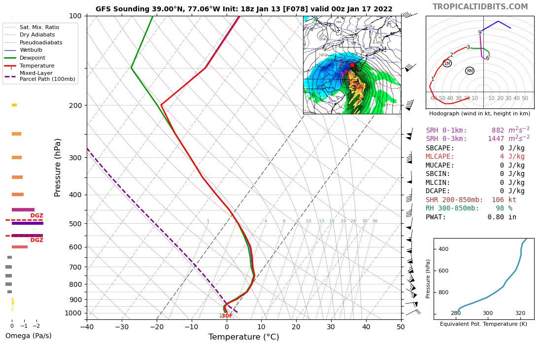
We know to a pretty good certainty that the 850 low is going to go over or just west of DC. What that practically means in terms of timing, front-end thump, and ratio of snow/ice/rain is still to be nailed down, and that's where the meso models will help.
-
Everyone wants better modeling. The weenies did not understand the repercussions!
-
The NAM is much drier. Front end thump less impressive. Something to watch.
-
-
This is really the wrong season to root for a Wilmington to DC low track.
-
GFS still looks ok. ~0.5" QPF by the changeover close to 00z Monday near DC.