Kmlwx
-
Posts
13,687 -
Joined
-
Last visited
Content Type
Profiles
Blogs
Forums
American Weather
Media Demo
Store
Gallery
Everything posted by Kmlwx
-
Then again...clouds are one of our most common failure modes. I do think someone will get walloped tomorrow. But I might have been inclined to keep it at 30% with no CIG hatching. The CSU MLP guidance has not painted any 45% contour at all on today's runs. That said, the 30% on that guidance *is* centered over the DC region.
-
Afternoon LWX discussion mentions "significant severe weather episode" and "scattered significant wind damage reports"
- 2,598 replies
-
- 4
-

-
- severe
- thunderstorms
- (and 7 more)
-
Double post but deal with it We all need to just consider the outlook meanings as a whole. a severe report within 25 miles of a point can be VERY high confidence especially in highly populated areas where there are now an abundance of spotters and average joes sending reports in.
-
Well I also think exactly what we all thought would happen with the new outlooks this year, has happened. It truly is that with forecasting advances, 45%+ is just not going to be super uncommon anymore. Everything has probably shifted upwards a tier. So 60% may be the new 45%. I think we will continue to see a higher incidence of 45% wind days. It does *not* mean that there will be more outbreak days. We have to sort of re-train our brains at least on the wind side of the outlooks. We used to get super amped for a 45% wind day....that will be like a 30% in the past. Sure - it's better than 15% but it's not like a derecho is coming through. If 2012 evolved in this new outlook scheme - as SPC upgraded that night with the line approaching - we probably would have gotten a 90% prob...
- 2,598 replies
-
- 1
-
-
- severe
- thunderstorms
- (and 7 more)
-
Nothing new....we probably will really have no idea how it will play out locally until 10am tomorrow or later
-
CIPS is not super-honking (the threat is there - it's just more muted). If nothing else - I am hoping for an event where I am working from home for a change (or at least in the area...) That said - a confirmed TOR passed near me up in PA Saturday evening (the Houtzdale/Whiteside, PA one confirmed by CTP). Was a few miles away.
- 2,598 replies
-
- 2
-
-
- severe
- thunderstorms
- (and 7 more)
-
https://www2.mmm.ucar.edu/projects/ncar_ensemble/ainwp/?fbclid=IwZXh0bgNhZW0CMTAAAR3_KcoSRHWhY1lxCTCfOqSNC0AD8SUSmL_c7R_N8rtpvo-PsNNvuY3vuI4_aem_Stpgx3ntIqB8IVErFY76cQ Not posting individual maps since there are many toggles from the NCAR page - but NCAR highlighted areas would argue for continuing to shift the ENH eastward if it is correct.
- 2,598 replies
-
- 1
-
-
- severe
- thunderstorms
- (and 7 more)
-
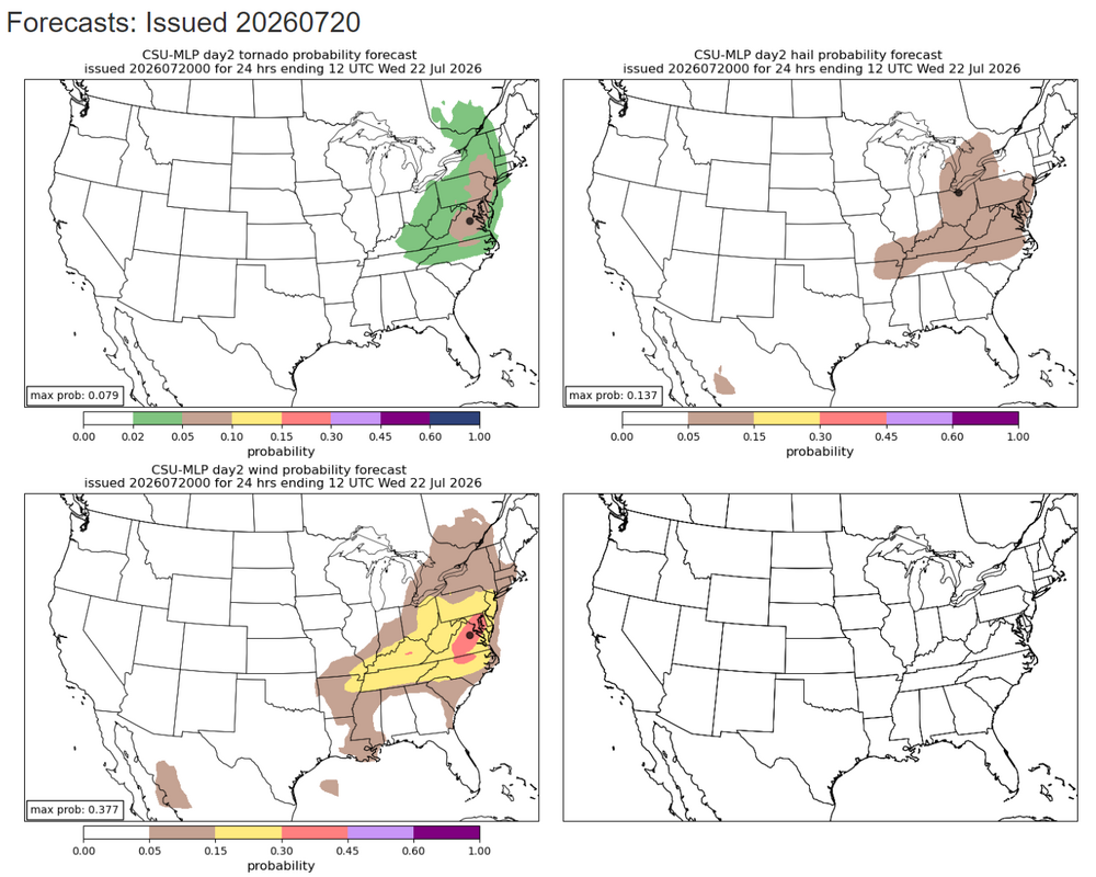
Latest CSU MLP guidance
-
Could end up being too far east for D3 and too far west for D4 lol.
-
I'll be out of town on Saturday (still in the slight, but still) - so I expect a massive severe line to wipe out the DC area.
- 2,598 replies
-
- 3
-
-
- severe
- thunderstorms
- (and 7 more)
-
Yep - it’s always the most likely scenario when outlooked that far out. Things will almost always trend earlier or later and either direction can of course be worse for timing.
-
If we are going by weenie superstitions that is a kiss of death.
-
The 12z GFS was very robust to our north with the EML plume middle of next week. It's focused up into PA but it's been jumping around a lot and varying in intensity the past handful of runs. This is the most impressive I've seen it depicted to this point. Large area of 8+ values up in PA. It then gets shunted off the coast without really getting across the M/D line (actually kind of comical how it kind of just stops at the border). This will be the thing to watch for severe chances next week.
- 2,598 replies
-
- 2
-
-
- severe
- thunderstorms
- (and 7 more)
-
@vortex95 - It sure looked like it had a bit of the "supercellular look" looking west from Odenton. Sadly didn't get any pictures - heck of a storm once it got to Odenton, though. Some shutters were torn off the condo building!
-
Not saying it will happen, but every now and then a lower parameter day will surprise and out perform the prior day. Always fun because it just goes to prove microscale stuff sometimes just says F known science and does its own thing!
- 2,598 replies
-
- 3
-
-

-
- severe
- thunderstorms
- (and 7 more)
-
Could go either way. There will be storms... Just not sure the severity. CSU still likes today.
-
Really interesting storm movement yesterday too!
-
This will be tough with the iterations of drone regulations happening the past few years. Especially in the DC/Baltimore region (and even extending to Southern Maryland, and down to Virginia Beach. Some of the most heavily regulated air space in the world exists here - and the concentration of major military installations contributes of course. Between JB Andrews, the SFRA around DC, Pax River down in Southern Maryland, and one of our biggest naval areas down in Norfolk - any mass drone event probably would be a tough sell.
-
Well - for us weather weenies - we either can read velocity/radar or follow people that can. So I feel like we almost gauge severity on a scale that average Joe doesn't
- 2,598 replies
-
- 1
-
-
- severe
- thunderstorms
- (and 7 more)
-
Sub-severe so far in Odenton despite being under warnings. Still nice to get a bunch of good thunder though - and some cooling rain.
-
WoFS is spectacular! Insane how far modeling as come over the years!
-
Andddd the USAF fighters were nuts. Probably not going to see a concentrated air power demo before my time on this Earth runs out lol.
-
AFSOC was even better.
-
They went straight over me hauling ass and banking slightly to exit the city. Insane.
-
Yeah that should be a great photo op. Side note - the more isolated restrooms here look like sheds from a 1980s horror movie… So far security hasn’t hassled me thankfully.