

Kmlwx
-
Posts
13,597 -
Joined
-
Last visited
Content Type
Profiles
Blogs
Forums
American Weather
Media Demo
Store
Gallery
Everything posted by Kmlwx
-
I'd feel much better if I was sitting down in Richmond or elsewhere in SEVA for this. I'll track it until we fail...but I'm just not sure this is going to be a win for us. Certainly a low probability thing up near mappyville.
-
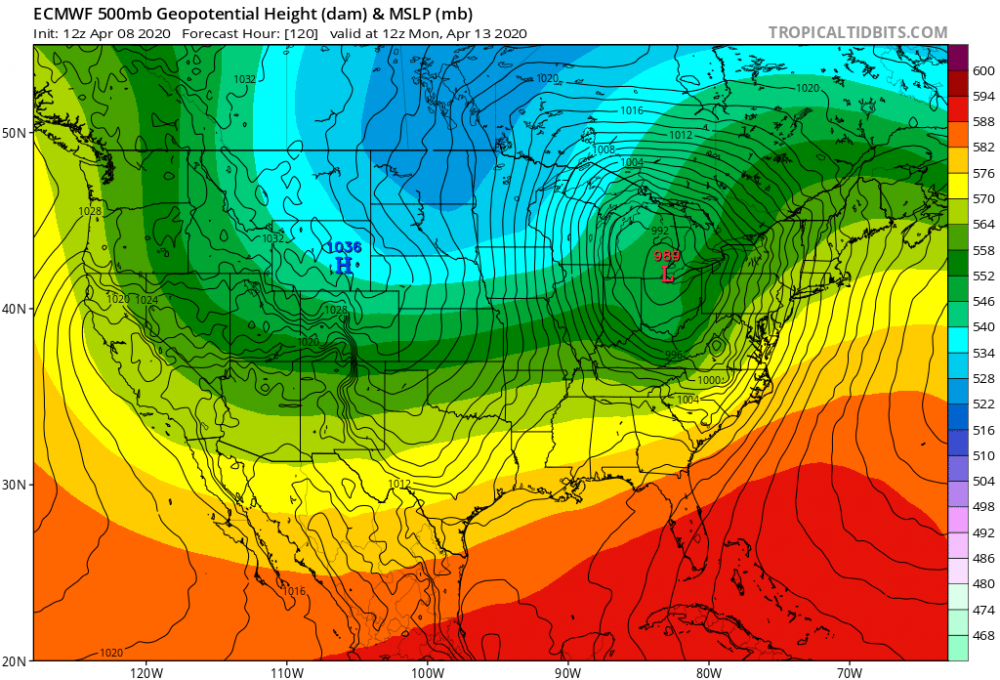
For Monday - The 12z EURO warms us pretty nicely (low to mid 80s in VA even). Has a little low down in southern VA. Not sure that'll do it for us up here. It'll be a close call regardless. Still time to go - a bit more of a slowing trend would help us as well perhaps. A front crossing between 21z and 0z would be ideal from a heating standpoint.
-
Attention gets to turn to Monday potential now. Latest GFS sends a little low through NC it looks like. Not going to do it for us.
-
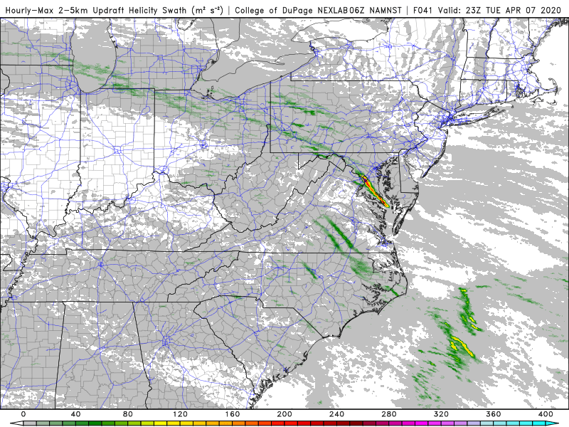
Take a look at those velocity returns behind the front back on the WV/VA border. Seeing 65mph pixels. Beam is a few thousand feet up there, though.
-
Interesting because that is a very common "starting point" for damaging wind cores into the metro area. I can recall a few that had a big bundle of great velocity returns on radar before dealing damage into the metro area. Believe there was one in July earlier in the 2010s.
-
Core of damaging winds.
-
CIPS has been pretty weak for our area...but it also goes off of the American guidance so I'm not surprised. I think Sunday is more or less off the table for us at the moment. Monday is definitely our window. I could see this being a relatively early day situation for us (before 1pm) - so we'll need to either hope it's one of those "don't need sunshine" days or hope for some continued slowing down of the system. That little low on the map above is going to be very jumpy the next few days. Suspect some runs it won't even show up on, others it might be too far south for us. Fickle hobby we have.
-
Usual caveats apply - and that's only 24 hour time steps. Wonder where it goes from there. I'm still mostly assuming we won't get enough warm sector...but we'll see how things trend in the next few days. Makes a huge difference if it goes ENE from there or if it rides the Blue Ride area to the NE.
-
12z Euro tracks the main low for Sun/Mon potential event up into the Detroit area. Has a little low in the vicinity of Bath/Alleghany County, VA at 12z Monday.
-
Memory post -
-
Would any small-scale influences like the Potomac have impacted that? Or maybe the boundary that was around the Potomac River from the activity earlier in the day? Or would those types not have been significant enough factors to change much?
-
It does seem like for tomorrow - east of our area has a better shot. As much as I don't want to jump to 80s and humidity very quickly...it would be fun to get some exciting bonafide severe days in here soon. early April is still a bit early of course...but this is the time of year when it's not quite as hard as March or earlier. Hoping we can track something more than gusty showers. The storms last night were pretty nice - hell of a lightning show in the 4am hour .
-
Monday looks like our shot from the big storm system. If the slower solutions are correct there could be some decent warm temps on Monday and storms.
-
I've had some signal differences with the 162.450 frequency at my parent's house compared to the past few years. Certain parts of the house that got great reception before, no longer do. And corners of the house where it would seem no radio signal could be received are now excellent. 162.550 used to be my go-to until the 450 one came online.
-
Much of the guidance gets us to at-or-above 70 degrees on Monday. There could be a severe risk then - as also pointed out in the D4-8 from SPC. Still looks like the big time threat will remain well south of the area for the potential Easter Sunday outbreak that is being modeled. Doesn't look like much for us today until you get down into Southern Maryland - maybe a few cells. We'll also keep an eye on tomorrow of course.
-
Thunder and gusty winds would be fun. Even if we don't see anything locally for Sunday - just seeing some of the guidance for areas of the Southeast is pretty freaky.
-
And there's plenty of time to move things around. I'm sure we're not at the final setup on the models. We'll see where we stand later in the week. Would suck if most of us miss out on appreciable storms tonight, tomorrow, Thursday and then the weekend too.
-
It looks intense - but primarily for the SE. I'm not convinced we see much of anything up our way other than rain maybe. Bears watching for sure.
-
LOL. The 12z HRRR sends a big time cell right through Frederick County, Montgomery County and Howard County this evening.
-
Yeah...I think NoVa could get some activity. Certainly far west of our area looks much better. We'll find someway to bust on all three days.
-
@yoda - I read that more as the storm potential will extend into our area - not necessarily that the hatching would come into our area. CAMs are a mixed bag it seems - I'm underenthused for today locally..for now.
-
LOL
-
The 06z run of the 3km NAM had a nice complex coming through the DC area tomorrow afternoon/evening.
-
SPC indicates some potential for Wednesday.
-
Don't believe anything is going to be in the cards for MBY this evening. On to the next event up here!


