

Kmlwx
-
Posts
13,333 -
Joined
-
Last visited
Content Type
Profiles
Blogs
Forums
American Weather
Media Demo
Store
Gallery
Everything posted by Kmlwx
-
Ohhh man. If you're close to going big...
-
The realist in me is expecting gusty showers or a gusty squall at best. But Feb 7 remains pretty highlighted in my mind. Things certainly haven't trended badly for us if you want some excitement. And if the recent Euro runs are right - we might do it all over again about 7 days later.
-
Of note - the Euro (and to a much lesser extent the GFS) are still hinting at another storm system around the same time the following week. Euro has a 980ish low to our north still.
-
06z GFS has 925 winds of 65kts over the area 15z Monday. Still pretty strong at 18z too - but the best winds are pulling north and east by then.
-
The 06z NAM appears to have been an improvement again. SARS is even lighting up with sounding matches from the database at some points in our area. It maintains instability and puts good supercell and sigtor parameters in our area Mon.
-
80kt 850 winds at 12z Mon AM on the 00z NAM over the area.
-
Pulled a forecast sounding from the NAM - right around Loudoun County - and it has 1800ish J/kg of CAPE and a ridiculous looking hodo.
-
Yes was just going to post - there is legit instability in the corridor on the 0z NAM. Still the NAM out in time, though. We'll see what the GFS says - I'm sure it'll be down to Earth a bit more.
-
And it looks like around 55-65 knots around 925mb at 12z Mon morning. Looks like the height for that is around 720m - so a bit over 2,000ft. Wonder how much of that will be able to transfer down to the surface in showers/storms.
-
12z Euro at 240 has another big time storm system. Has a sub 980mb low in northern Ohio. Maps suggest that could be another threat.
-
Easily would be similar to April 27-28 2011 - but of course maybe not with that duration. The duration on that event was something I'm not sure we're going to see again outside of a tropical system.
-
Imagine getting this same system with 85 degree temps and 70 degree dews in a month or two...and better timing maybe.
-
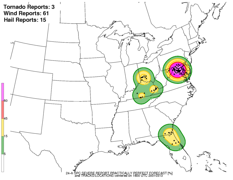
Well it's weird because the PPF shows a big blob over us with reports. SPC Storm Archive appears to go back to 2000 - maybe some events are missing? Lemme grab a screenshot. https://www.spc.noaa.gov/exper/archive/events/ There's a 3/14 event - but it doesn't match this at all.
-
It's showing an event from 03/13/2001 but I can't find anything matching that in the SPC Event Archive. I wonder if the date is wrong...
-
96hr mark on CIPS is starting to light up more than before.
-
I haven't even looked at any potential of big synoptic wind behind the system either - with a storm of this nature that's always a threat as well. And like you said, any strong winds on saturated ground is going to do some damage. I still maintain that I'd prefer to be down in SEVA - but things look okay right now even up our way. Encouraged also by these dynamic systems - gives me hope we can line up something in May or June with a lot more instability and maybe still good shear etc.
-
I think the biggest questions we need to answer are - How much surface based instability is going to be available locally in DC/Balt: Right now that looks like maybe a max of 500J/kg in a narrow tongue - Will the wind field be well-timed with whatever we get?: Models had been suggesting the best winds would be racing well east of our area by 15z, that slowing has continued, though. - Does any sort of mini-low form separate from the system? It looks more consolidated on some of the more recent guidance.
-
The one thing that keeps me muted on Monday (other than our usual "we always fail" mantra) is how much rainfall is progged for Sun night to Mon AM - that could serve to just stabilize the heck out of us.
-
In fact, that GFS run seems to indicate there could be some instability around in a narrow band at around 15z. Also, some of the winds at 15z and 18z are stronger than last run. Keep the trend going!
-
6z GFS was a smidge slower again it looks like.
-
Looking at the sounding climatology page on the SPC site - it looks like some of the 925mb and 850mb wind speeds the models are putting out for Monday around 12z, they'd be near record levels...not just for the date but in general.
-
Last 4 runs of GFS - clear trend.
.thumb.gif.5e21fd990164ecb6991d43dd94705a89.gif)
-
At some point, the trend is likely to slow or stop...and the GFS is still a fast outlier. Easy to toss with the other models against it - but it could also be a compromise. EE rule? lol
-
Also - while not a BIG signal by any means - the 108hr on CIPS from from the 12z suite is showing some severe potential in the Mid-Atlantic/PA area. 5/6-7/1991 is showing up for a few runs now. 4/16/1994 as well 4/19-20/2013 which looks good on the maps.
-
I'd feel much better if I was sitting down in Richmond or elsewhere in SEVA for this. I'll track it until we fail...but I'm just not sure this is going to be a win for us. Certainly a low probability thing up near mappyville.


.gif.a71b998b86c1e9b31fb4e012f5b3694b.gif)
