ORH_wxman
-
Posts
93,099 -
Joined
-
Last visited
Content Type
Profiles
Blogs
Forums
American Weather
Media Demo
Store
Gallery
Everything posted by ORH_wxman
-
Just weekends or Saturday I think.
-
Getting a bit blocky up in Canada. Things can happen when that occurs.
-
No, they hit 0F exactly. This would be two years in a row not getting below 0F. It happens about 10% of the winters historically. But it’s been more like 25% since 1990. Last time it happened back to back though was 2000-2001 and 2001-2002.
-
Anything near the Holden line is going to be good....it's all 600-800+ feet there and NW side. That's where the snow retention is and where the icing events are more noticeable. Often night and day there vs like Webster Square or downtown.
-
Same ridge placement as April '97. Tight squeeze....esp in early March, but it is plausible.
-
I've already marked the ORH map for him to show him the best spots in the city.
-
Yeah the OP Euro was somewhat interesting there. Wouldn't take a big change to wrap that into New England. You need that trough to dig further southwest and try to phase with southern stream.
-
Hes actually on the opposite side of town down south where I am on the northwest corner almost in Ashland/Hopkinton and more elevated so I'd be a bit higher naturally. I can def say if an area is getting a lot of sun during the day it is likely under 7". He did make this comment:
-
Yeah he posted pics there from last May and it was like over a foot of powder....like 2 days after the snow happened, lol. Apparently the snow depths in that area are legendary for the brae riders who get out that far. Always hard to say what an area would average when there's nothing close by to compare it to, but it looks like it would be at least as good as Diamond Pond, NH for upslope (slightly different optimal flows, but net benefit at least the same I'd think?) plus they probably do significantly better than places like Diamond Pond on synoptic snow. They would get topo assist on those types of flows too. Given Diamond Pond averaged 230" in its short existence, prob not that much of a leap to think Kibby is 300+
-
Yeah you couldn't see any of that grass line even 3 days ago....it's amazing how fast the sun works on those edges this time of the year. Full blown Tip nape season.
-
A house up the road had a snow blower path across their front lawn and it has widened now into a massive gap just splitting the lawn in half. Amazing how much assistance it gives the sun these days when there are darker spots.
-
Lol that isn't me.
-
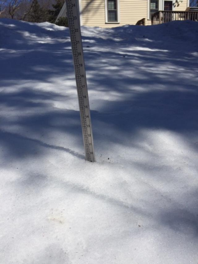
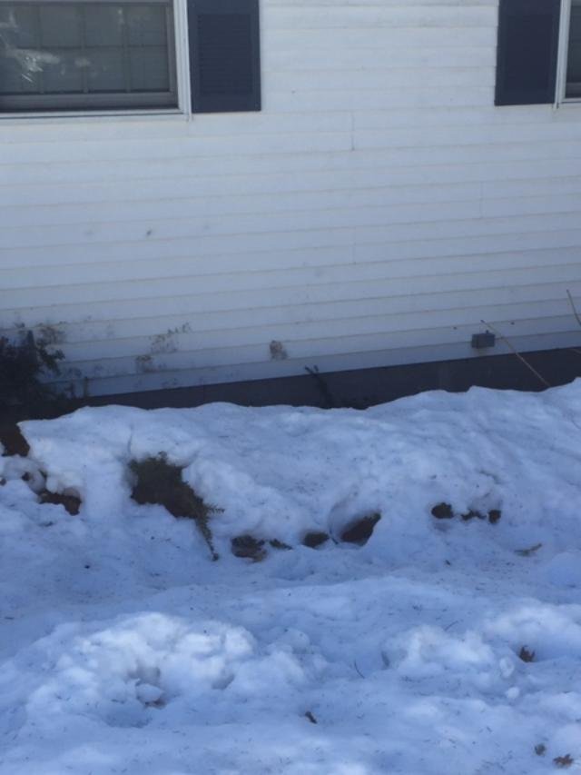
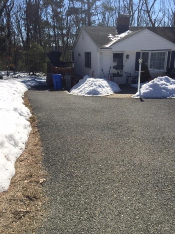
Fell under 10" here....prob some time yesterday (I actually haven't touched the snow stick in days...starting to tilt a little, lol). You can see the pack receding pretty good from the edge of the driveway now.....though the very front of my house which stays shaded is melting out a lot slow. These bushes are just becoming visible, lol. Of course, as I posted yesterday, I've fallen behind winter hill now. I was pretty even with them for a lot of the month given that I did as well as them during the 2/1 event and even better than them during the 2/7 and 2/19 events. But 2/22 was the turning point...they got an inch of slop as a bit of barrier and then the sneaky torch days that followed hit harder here than there. This was winter hill last night...they had a solid foot left up there at least, maybe more in the shadier spots:


-
GGEM shows you how it could happen. I think I mentioned yesterday how that trough would need to dig for oil a bit and this run does that. I agree with Tip on being skeptical of such a solution aside form just the lead time...you have to overcome some gradient in the flow. But that ridge out west does get very amplified which helps it overcome other forces and it pinches off into a rex block.
-
That snow coverage map really shows the lingering effects of the 2/1 event well in eastern MA.
-
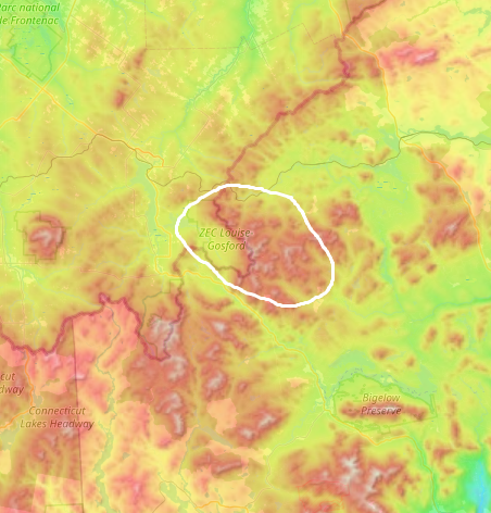
If there was one spot I had to pick to place an observer where we don't have one in the east, it would probably be Kibby Mountain Maine. They probably get walloped with upslope and likely benefit from a lot of the coastal storms. They are nestled in basically a horseshoe-shaped area of very high elevation with a lot of flat topography off to their W and NW. The snow up there is legendary for snow mobilers who bother to make the trek as dryslot often mentions.
-
We used to get 30 to 1 or even 40 to 1 blower powder on LES all the time back when I went to school out in ITH. The ratio does come down a bit in heavier events simply due to the settling that happens naturally. Hard to go 40 to 1 on 20 inches of snow.
-
Yes, it basically takes the GEFS mean for that frame and tries to match it to the closest H5 pattern historically. They have two different days we can choose for the analog composite...D8 and D11. (the other days on the left hand menu do not produce analog composites) https://www.cpc.ncep.noaa.gov/products/predictions/short_range/tools/model_guidance.php
-
That's from the GEFS I'd assume. They have two analog options there....one from the GEFS and another from the GEPS (GGEM ensembles).....too bad they don't have one from the EPS which would be more useful.
-
Doesn't BW still have it on weekends? I could have sworn I saw them advertising night skiing when I was up there a few winters ago, but it was for weekends. Cranmore has night skiing too on Saturdays unless they changed it. Shawnee is probably the best one semi-close to him...it's like an hour drive but they stay open until 9pm.
-
Same here....this morning it was just a pure glacier and I didn't sink in at all.
-
EPS shows some mild potential there....it would be a late bloomer probably but if you get something deepening quick enough on that trough diving in, then you could get a surprise there.
-
Getting pretty late down south....we're def not done with snow in interior New England (and prob not the coast either), but the climo temps are rapidly warming.
-
Still a pretty impressive pack on winter hill. I was running neck and neck with them for most of February but they’ve pulled ahead.
-
Yeah we're rarely done by 3/15. Really the last year we were was probably 2014 (the Cape wasn't, lol)....I guess 2017 for closer to the coast was done after the 3/14 storm, but 3/31-4/1 got the interior.