

ORH_wxman
-
Posts
93,099 -
Joined
-
Last visited
Content Type
Profiles
Blogs
Forums
American Weather
Media Demo
Store
Gallery
Everything posted by ORH_wxman
-
When we refinanced, we had home insurance left out of the mortgage payment. We just pay it as a lump sum once per year now. I don’t think we could get the tax escrow removed though because that’s the bank’s insurance against you not paying. Most mortgaged homes don’t go to tax sale anyway and the bank will advance money to prevent a sale, but many don’t want to even bother with the possibility so they require the tax escrow.
-
Happened to us 2 years ago, but yeah, it wasn’t a massive difference per month like Tauntonblizz. I think our payment increased by about a hundred bucks. We refinanced last summer at 3.2% and saved double that.
-
There will definitely still be some stragglers that are remote. I think it was already decided that people can opt out the whole year back in the beginning. I think they’ll be able to resume physical labs though when in-person goes full again. It’s definitely going to be a lost year for some students which is terrible. My oldest son goes into kindergarten next year so hopefully they are fully back to normal by then. We’ve been lucky that his daycare has been functioning relatively normal during this so he’s been able to get lots of social interaction with his peer group. Only the dropoff and pickup procedures were drastically altered. Masks were only required for the teachers at daycare too, but most of my son’s pre-K class wear them (minus snack, lunch, and nap times) so he’s gotten some practice. My 18 month old toddler obviously doesn’t wear one. Luckily in my town, the elementary school kids have been full time all school year. They just have to wear masks though. Hopefully those are gone by fall but I wouldn’t be shocked if they aren’t. At least we won’t really have to worry about any remote learning. It’s especially damaging to the younger elementary aged students.
-
My wife’s school district (Walpole high school) has been hybrid all year. Students go about half the days in person and half remote. They are going back to full in-person the 2nd week of April.
-
Went skiing at Keystone and A-Basin in April 1993....was pretty amazing how strong that sun is. Also, there was basically no snow until about 8,000 feet elevation and then by 9,500-10,000 feet (really high base elevations at those resorts) it was basically full-on winter, however, that sun angle was brutal. The first day we were there we got mild sunburn even though my dad was careful to put sunscreen on our faces. It was pleasant around 35-40F for highs and dry. Then the next day we got hit by a raging powder blizzard that dumped 20 inches of snow. When we skied A-basin the day after, you couldn't be outside without goggles or sun glasses. The fresh snow with the April sun angle was unbearable without them.
-
We always find a way to keep busy in here with busted severe threats and under-performing heat waves.
-
With a last gasp effort, winter 20-21 refuses to give up the ghost
ORH_wxman replied to moneypitmike's topic in New England
Yeah it's out of here by like midnight on a lot of guidance now. It was supposed to be an event that lasted into Friday morning originally. Then it was mostly 06z to 09z for the heavy snow. Now all that moisture is gone. The cold air wasn't delayed at all...if anything, the press is too strong and it's shoving the moisture SE. -
With a last gasp effort, winter 20-21 refuses to give up the ghost
ORH_wxman replied to moneypitmike's topic in New England
NAM actually has no snow at all now...maybe some flakes on the Cape? -
Yeah like 3/30-4/3 or so could produce a threat if that look holds.
-
With a last gasp effort, winter 20-21 refuses to give up the ghost
ORH_wxman replied to moneypitmike's topic in New England
I’d prob go 1-3” based on the overnight runs. The precip is moving out very quickly on those runs. We’ll see if it reverts back a bit on the 12z stuff but if not, then I’d be surprised if anyone got more than 3”. -
With a last gasp effort, winter 20-21 refuses to give up the ghost
ORH_wxman replied to moneypitmike's topic in New England
I was just going to comment how the off hour runs have consistently been pretty meh while the primary runs have jacked up amounts. -
With a last gasp effort, winter 20-21 refuses to give up the ghost
ORH_wxman replied to moneypitmike's topic in New England
Lol nice scooter jack on the rap. Not buying that distribution though. -
With a last gasp effort, winter 20-21 refuses to give up the ghost
ORH_wxman replied to moneypitmike's topic in New England
Assuming this doesn't all of the sudden get squashed SE ala 06z NAM, a good test will be to see where the snow line is around 03z tomorrow night...if it's already snowing around ORH up to your hood by 11pm, then it's prob game-on for at least solid advisory. But if we get to 1-2am and we're still screwing around with sleet/rain near the MA/NH border, then it's prob lower end. -
With a last gasp effort, winter 20-21 refuses to give up the ghost
ORH_wxman replied to moneypitmike's topic in New England
Yeah I'd prob cut the Euro 10 to 1 map in half. Not sure why Kuchie went wild....but I also don't think 8" in 5-6 hours is happening. I could maybe see 4-6 though where it snows very heavily for 3 hours. -
With a last gasp effort, winter 20-21 refuses to give up the ghost
ORH_wxman replied to moneypitmike's topic in New England
That was the NAM actually. It does collapse it SE...here is 09z.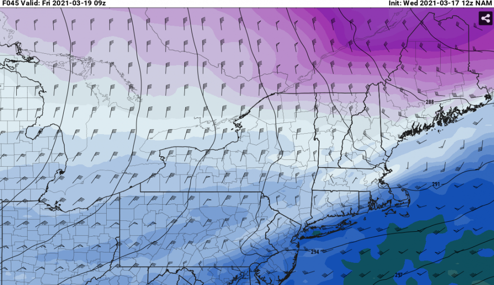
-
With a last gasp effort, winter 20-21 refuses to give up the ghost
ORH_wxman replied to moneypitmike's topic in New England
Here's 700 at 06z Friday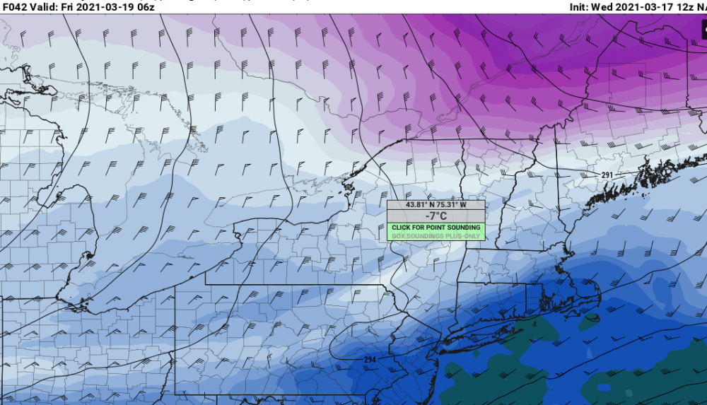
-
With a last gasp effort, winter 20-21 refuses to give up the ghost
ORH_wxman replied to moneypitmike's topic in New England
LOL V16 GFS goes insane with the band...it's only like 4-6 hours but it tries to drop 2" per hour. It is hard to buy those depictions, but can't rule out some pretty intense snow for a few hours if things break right. -
With a last gasp effort, winter 20-21 refuses to give up the ghost
ORH_wxman replied to moneypitmike's topic in New England
GFS juiced back up....not an easy forecast. -
With a last gasp effort, winter 20-21 refuses to give up the ghost
ORH_wxman replied to moneypitmike's topic in New England
That's a pretty sick band from the pike up into N MA border region. -
With a last gasp effort, winter 20-21 refuses to give up the ghost
ORH_wxman replied to moneypitmike's topic in New England
Yeah we haven't had hardly any of those this seasons. Your area to dryslot will often share the goods with SNE on some of those coastals...much moreso than NW New England near powderfreak/BTV. Even 12/17/20 struggled to really push north. It did get you to dryslot with some decent snow but the bulk was south...the storm kind of shunted due east once making it to a certain latitude. Some years like 2017-2018 or even 2014-2015 have a whole bunch of storms that have the SSW to NNE swath of snow that gets most everyone in the eastern 2/3rds of New England. -
With a last gasp effort, winter 20-21 refuses to give up the ghost
ORH_wxman replied to moneypitmike's topic in New England
It's very intense too for like 3-4 hours there...so if we're flipping to snow by midnight over interior, then it's going to produce a quick 5-6", but if it kind of waits until 2-3am, then it might just be a couple inches. Taking advantage of a couple extra hours of that really intense fronto will be key. -
With a last gasp effort, winter 20-21 refuses to give up the ghost
ORH_wxman replied to moneypitmike's topic in New England
18z NAM gone wild -
With a last gasp effort, winter 20-21 refuses to give up the ghost
ORH_wxman replied to moneypitmike's topic in New England
The fronto gets pretty strong on this....the biggest risk here is that there is about a 3-5 hour period of legit heavy snow with temps plummeting below freezing from mid/upper 30s rain just prior. So there could be a very fast 4-6" with a flash freeze....that's prob worst case scenario in this. Maybe somewhere in elevated W MA or N MA maybe sees something a little more than that, but not really buying 8"+ at this point. But even high end advisory snow with flash freeze is plenty bad on Friday morning. -
Wow, GFS is pretty impressive for Friday morning too. Further SE than the NAM, but it hits most of MA hard....Scooter jack?
-
RGEM is an impressive flash freeze widespread advisory snowfall event. Temps in the 20s during Friday as the snow lingers. Seems to get a lot of the forum eventually.


