ORH_wxman
-
Posts
93,099 -
Joined
-
Last visited
Content Type
Profiles
Blogs
Forums
American Weather
Media Demo
Store
Gallery
Everything posted by ORH_wxman
-
You are on zoom with the same teacher. But the reason they banned others from doing that is because they want the teachers to just be teaching the class in-person and not to have to multi-task teaching both in person and remote at the same time. Most teachers don't have any students in covid protocol at any given time.
-
My wife's school district banned any remote learning if you weren't in covid protocol. If you just didn't feel like going to school because you were sick (non-covid), you are absent that day and no remote learning. They just went back full time....previously was a hybrid model.
-
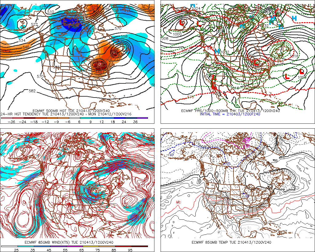
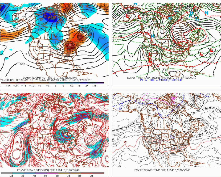
Just saw EPS....other guidance shows this as well. Def a chance for some late season shenanigans. We'll see if that ULL look is still there in a few days, but a lot of support at the moment for it. Hopefully we get a threat out of it....beats dogshit 40F and rain.
-
I was in the full fury of it.....
-
Yeah ‘02-03 was moderate. Same with ‘86-87 and ‘87-88 which were both solid years.
-
Don't disagree that blizzards will likely eventually become rarer down the line at some point, but how much rarer? I don't buy any estimate that is something akin to frequency in, say, current day Philly or DC. Really the most pessimistic climate models have us warming about 5-6C.....but those aren't exactly realistic scenarios either. They are plausible, but need a lot of assumptions to verify. Those occur in scenarios where we assume that we do stuff like multiply our coal energy output by 6x (despite likely already peaking globally) and basically have zero conversion to zero-emissions energy. It assumes rising emissions to the year 2100 to near 1200ppm CO2. The more realistic scenarios are something like 2 to 3C. Maybe BOS becomes more like Cape Cod and ORH becomes more like BOS (though still more favorable geographically with coastal fronts, etc).
-
We'll never stop having blizzards. Even a place like DCA gets them and they average about 6C warmer than we do in the winter....we'll never reach that warm...prob wouldn't even get halfway there. In addition, New England is in a more geographically favorable location anyway sticking out into the Atlantic.
-
Getting 9.6" on 12/5 turned out to be the difference (barring something weird happening this month)
-
No, You are def more than 73". Though 84" might be a bit on the high side if we did a long term average. I don't think the GYX average is 30 years though....I think they only started in 1996. If you included the putrid 1980s into the 1981-2010 normals, then they would be less than 84".
-
2nd lowest April max all time in ORH during that one with a high of 22F. Only April ‘82 had a colder high (21F).
-
I got J&J and it was one shot and easy. Had a little soreness in upper arm for a day but that was it.
-
Too bad we couldn’t see another frame on the Euro just for kicks.
-
Red Sox? Dude, have you seen the Orioles and Pirates? Rockies? Rangers? I'm sure I"m forgetting several.
-
Prob a good thing...it will postpone the Mets disappointment a little longer.
-
Same....I hadn't heard of them until Kevin told all of us on here that we should already know who they are.
-
The famous Scooter mid-1990s Starter Bruins jacket pics.
-
Only a matter of months until we become a real life version of I Am Legend.
-
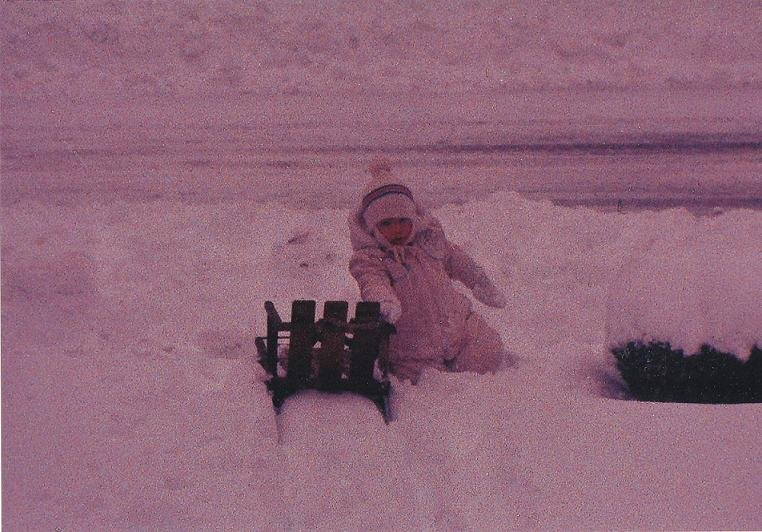
My only regret in that storm was I didn’t see the snow between about 1am and 6am. That was obscene rates there. Still, seeing thunder snow right as we were getting out of school around 2:15pm was pretty awesome. Vivid flash and loud crack just about 2 seconds behind it while it was absolutely choking aggregates. Couldn’t see more than about 200 yards at that point.
-
Yes. I was thinking that it wouldn’t be totally weird to see a threat in that 4/8-4/15 range given the look. We did get a solid advisory event on 4/18 last year after all. You never know....get a big ULL and weird things happen. The double barreled back to back snow events on 4/7-4/8 and 4/9-4/10 in 1996 occurred on a big ULL rotating around for a few days.
-
Correct. You have to get on their list each day. But I got called the first day, lol. They said it happens all the time. They were happy to give it to people and not throw out the doses.
-
Yeah getting blocky again. That would have been a great pattern 2-3 weeks ago.
-
I got the J&J shot 3 weeks ago and had no side effects other than a sore upper arm for a day. I managed to get it at the local CVS by getting on their waiting list for “no show” appointments. At the end of each day, if they’ve had any no-shows, they’ll have open viles of the vaccine with doses left in there (they have 5 doses per vile). So they either have to throw them away or use them that day. So that is how to get the vax if you aren’t officially eligible yet. You get on the use-it-or-lose-it list.
-
'Rhea in April around here is as dependable as Ray b*tching about not jackpotting in a snow threat.
-
Could probably sneak a series in before Xmas too. Maybe a 12/23-12/24 two gamer?
-
We had flipped to snow by this point...around 10am we flipped.