ORH_wxman
-
Posts
93,099 -
Joined
-
Last visited
Content Type
Profiles
Blogs
Forums
American Weather
Media Demo
Store
Gallery
Everything posted by ORH_wxman
-
We will have a good idea of how things are progressing by about midnight or 1am. If we are seeing a place like ORH flipped before midight, then it could be pretty prolific there. That's assuming that we don't get a low that drives back into your fanny and dryslots 2/3rds of SNE too....but I'm doubting those solutions at the moment as I watch each run of the RAP/HRRR.
-
Yes, we wouldn't be sweating these wiggles when the column is 8C to 10C colder in mid February. But in mid-April, they matter.
-
The key is how far west it eventually makes before looping back SE...so we see it eventually make it to RI after crossing the western Cape and then it loops back to ACK....if the peak western advance is, say, PYM or GHG instead, then that matters a lot for that 495 belt.
-
It's not great for inside of 495...tries to wrap in some warm air at 925. It's a crusher though for west of there.
-
Eventually, but it makes it there via Cape Cod...that matters versus doing it via like EWB.
-
Euro is west of 06z, but still slinghsots the low over CHH and Cape Cod Bay.
-
Yeah I don't expect a repeat, that was too crazy. But the key for me is seeing if this low slingshots over the Cape versus like EWB to PVD.
-
There's some similarities with the marginal aspect of the temps but the evolution is different and frankly, the profile looks colder than that one...at least on these dynamic solutions they do. But we obviously have the time of year working against us near the surface where it is felt the most.
-
You mean 12/5? That was the storm that had big snow in ORH but pretty meh inside of 495 because it was barely too warm.
-
The locks are Berkshires/S VT/Monadnocks and maybe extreme NW Litchfield hills in CT?. Also hard for me to see how a place like N ORH county at elevation doesn't get whacked....I suppose the GFS could score the coup and it's a sloppy 2". But most other guidance has warning snowfall there. The tougher spots are adjacent S ORH county into N CT/NW RI and then the 495 belt. Those areas could legitimately be 6-10" or almost nothing.
-
Snow for Scooter while Ray is raining?
-
That's prob low for your 'hood.
-
Yeah this is a unique set up where the higher terrain could actually be pulling greater than 10 to 1 in the heaviest bands but then for several hours on each side of the truly heavy stuff, they are getting 5 or 6 to 1 slop. Below 500 feet I'd prob say you aren't getitng better than 8 to 1 even in the heaviest banding....maybe 10 to 1 if you are in the 300-500 foot range. We have to figure out which model to believe first though. Something like the GFS is pretty snooze-worthy to the east of the Berkshires and monads because it drysots everyone pretty fast.
-
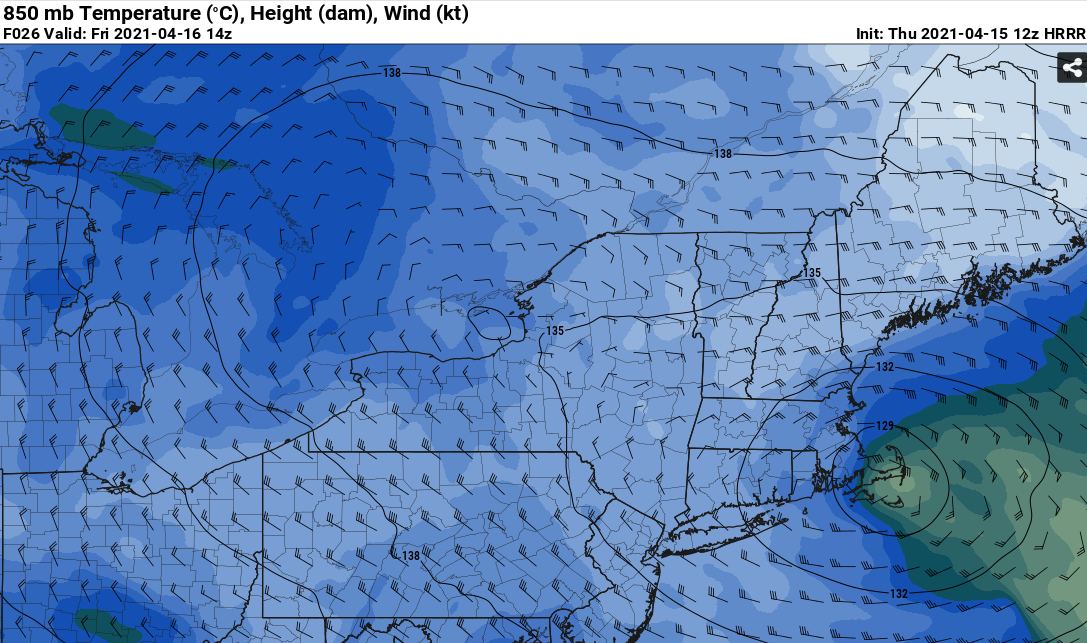
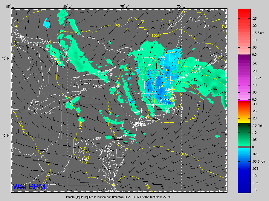
15z HRR looks pretty awesome too for interior MA/E CT/NW RI
-
ORH grid collapser. It's def west of the 09z run though which jackpotted E MA. 12z Canadian looks pretty meh....though it is SE of the 00z which was really far west.
-
Yeah if GFS verifies, prob basically nothing here. ORH would probably still get decent snows with some elevation, but you're looking at mostly nuisance crap to the east. We want a 06z Euro/12zNAM/RAP/HRRR type solution.
-
It's like a 12/9/05 type death CCB before it slots/occludes.
-
RGEM curls the low pretty far west this run now. Kind of like 3km. Def some model wars at the moment. The HRRR/RAP agree with 12km NAM more while the 3km NAM agrees with the RGEM more. RGEM is prob more pessimistic than 3km NAM. It's pretty warm.
-
Holliston near the Ashland/Hopkinton line...not that far from you actually. But I'll prob be up at winter hill in ORH tomorrow morning.
-
3km NAM has like 8-10" 10 miles west of me while I get nothing, lol. Doubt that happens, but that would be a good toaster bath. I am prob heading to winter hill anyway though for this one. Still a decent amount of variability though on the model guidance in terms of exact stall location of low.
-
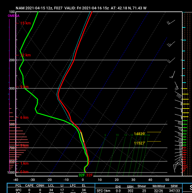
LOL, this isthe NAM sounding over me at 15z tomorrow. Look at that cross-hair sig
-
Just make sure you move into those areas I highlighted for you on the north and west sides of the city. There can sometimes be a big difference between them and the south or southeast side at lower elevation. Although since you are moving from near Philly, it will all seem a lot snowier regardless.
-
Yeah getting 495 zone pretty good this run whereas previous runs were more confined to the farther interior hills.
-
12z HRRR is pretty awesome looking tomorrow morning.
-
Prob get some decent convection right near the edge of the dryslot.