ORH_wxman
-
Posts
93,092 -
Joined
-
Last visited
Content Type
Profiles
Blogs
Forums
American Weather
Media Demo
Store
Gallery
Everything posted by ORH_wxman
-
January 2026 regional war/obs/disco thread
ORH_wxman replied to Baroclinic Zone's topic in New England
Scooter high special -
January 2026 regional war/obs/disco thread
ORH_wxman replied to Baroclinic Zone's topic in New England
18z GFS trying to make this interesting on 1/18-19....not gonna quite get there but that was a pretty good sharpening of the trough compared to previous runs. -
January 2026 regional war/obs/disco thread
ORH_wxman replied to Baroclinic Zone's topic in New England
Yeah that was a pretty decent trend toward those GEFS members on the icon. Want to see euro get more enthused though. -
January 2026 regional war/obs/disco thread
ORH_wxman replied to Baroclinic Zone's topic in New England
Not to mention we’ve had several systems that were initially amped get crunched SE and whiffs or something less impressive…even including the “cutter” this past weekend which ended up a sheared out piece of trash with lots of CAD. -
We definitely believe you. Just add in a few more smiley faces to really convince the rest.
- 583 replies
-
- 10
-

-

-
January 2026 regional war/obs/disco thread
ORH_wxman replied to Baroclinic Zone's topic in New England
Hopefully it looks more like this than a cutter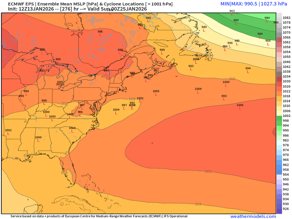
-
January 2026 regional war/obs/disco thread
ORH_wxman replied to Baroclinic Zone's topic in New England
Oh it’s there. Might get interrupted briefly by a nice cutter but it’s there. We’ll finish January BN on temps unless there is a huge shift in guidance post-weekend. -
January 2026 regional war/obs/disco thread
ORH_wxman replied to Baroclinic Zone's topic in New England
OP euro is trying for 1/19-20. Actually hits CNE/Maine pretty good. Gets MA with light snows. A little late developing. -
January 2026 regional war/obs/disco thread
ORH_wxman replied to Baroclinic Zone's topic in New England
Going bye-bye with the big WPO shift again. We warmed up due to the AK/Bering vortex…but back to the heavy -WPO after this week. -
January 2026 regional war/obs/disco thread
ORH_wxman replied to Baroclinic Zone's topic in New England
Yeah which is why I’m looking forward to the gradient pattern at this point. We might get a cutter but at least there will be QPF events to track in that type of pattern. -
January 2026 regional war/obs/disco thread
ORH_wxman replied to Baroclinic Zone's topic in New England
Meridional flow definitely overcomes a lot of imperfections. -
January 2026 regional war/obs/disco thread
ORH_wxman replied to Baroclinic Zone's topic in New England
The funny part is it never corrects itself. I’ve seen countless threats that had interference but it was overcome either due to vort strength or one of the shortwaves changed slightly. But we’ve never trended away from it recently. -
January 2026 regional war/obs/disco thread
ORH_wxman replied to Baroclinic Zone's topic in New England
I’ll give 1/18-19 another day or so to trend better but otherwise yeah, we wait until post-1/20 -
January 2026 regional war/obs/disco thread
ORH_wxman replied to Baroclinic Zone's topic in New England
Unlikely we get anything of note. I’ll still hold out a little hope for 1/18-1/19 but we need some good trends on that over the next day or two. -
January 2026 regional war/obs/disco thread
ORH_wxman replied to Baroclinic Zone's topic in New England
What the most interesting out of the entire synoptic landscape over the next 7-9 days is that we see this mean trough in an almost ideal spot over the eastern third of the CONUS with multiple shortwaves that dive into that mean trough and we fail to get a single decent QPF event out of it. It’s almost the anti-2015….surgical precision of somehow not producing. -
January 2026 regional war/obs/disco thread
ORH_wxman replied to Baroclinic Zone's topic in New England
Give it a couple weeks. We’ll get the inevitable Biloxi, MS blizzard warning while we have a thread for -15F low temps. -
January 2026 regional war/obs/disco thread
ORH_wxman replied to Baroclinic Zone's topic in New England
Last year was sneaky cold too (compared to recent winters anyway), though not nearly as cold as this one has been. Both winters have featured a dearth of big systems. It’s just been a lot of dryness. -
January 2026 regional war/obs/disco thread
ORH_wxman replied to Baroclinic Zone's topic in New England
That was a really good stretch actually after a very frustrating January. We got a moderate event on 1/26 which turned the tide and then we got a big dog on 2/1 and a pretty big event on 2/7. We had our pack over 20” for a time. -
January 2026 regional war/obs/disco thread
ORH_wxman replied to Baroclinic Zone's topic in New England
You mean we’re not gonna get 100” in 3 weeks? My forecast just got blown up. -
January 2026 regional war/obs/disco thread
ORH_wxman replied to Baroclinic Zone's topic in New England
They are tepid on both but prob more interested in that little follow-up wave on 1/20 than the 18th. -
January 2026 regional war/obs/disco thread
ORH_wxman replied to Baroclinic Zone's topic in New England
EPS is still quite snowy in the LR. They are not very interested in 1/18 though. They really seems to like the post-1/20 period. -
January 2026 regional war/obs/disco thread
ORH_wxman replied to Baroclinic Zone's topic in New England
Needs some work but I wouldn’t rule out an interior shovelable event yet for 1/18. I’m more optimistic beyond that timeframe though. -
A lot of the AK coast can be feast or famine like that. They’ll get destroyed for weeks but then they can go like 1-2 months with nada.
-
January 2026 regional war/obs/disco thread
ORH_wxman replied to Baroclinic Zone's topic in New England
Let’s tighten that vort a little more and crush 495. Close that run. -
January 2026 regional war/obs/disco thread
ORH_wxman replied to Baroclinic Zone's topic in New England
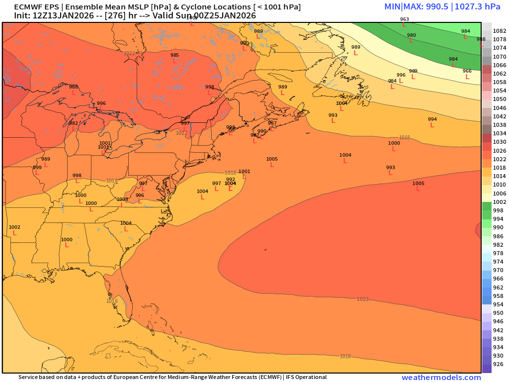
Couple nice beefy SWFEs in the extended on 18z GFS. EPS hinted at this too which is why it has been showing some snow in the 11-15 day. Would be nice to track some higher QPF systems. These less than half inch QPF events are getting brutal.