ORH_wxman
-
Posts
93,095 -
Joined
-
Last visited
Content Type
Profiles
Blogs
Forums
American Weather
Media Demo
Store
Gallery
Everything posted by ORH_wxman
-
The Tuesday system is getting colder too. Not convinced that one torches us...certainly for NNE.
-
ORH gusted to 49 knots a while ago...that's pretty good.
-
Pack melting fast here....backyard is mostly melted out....front yard still mostly covered but not for long.
-
And a few of our high QPF events were cutters. Those have so much run-off even if the pack survives them.
-
I made a comment yesterday or the day before on how even though I’ve basically had continuous pack since 1/7 (aside from right before the last recent event when that torch day in Saturday opened up large patches of ground), it didn’t feel like deep winter for much of the time because we generally had low water in the pack. Even after the sleet storm on 2/4 added some good water into the pack, it was only after a lot of melted the previous day, so it was only a minor net gain of LE. Typically over the interior, we’ll get a pack with at least 3-4 inches of water in it at some point but we’ve never gotten there. Places further NW like N ORH county will get 7 inches into the pack quite frequently, but it just hasn’t been that type of winter over the interior. We’ve really lacked those front ender type events and SWFE ls this winter. The 1/17 system was a front ender but that’s been one of the few…and even then it wasn’t a typical front ender that puts some sleet and ZR into the pack too…that one was like 6” and then straight to rain for ORH county.
-
I didn’t say anything was wrong with 1993. That march is the snowiest on record for both ORH and BOS.
-
I'm hoping for a 2018 finish....though the pattern isn't really 2018....more 1993 than 2018. Hopefully it doesn't end up like Mar 2015, though my guess is we'd do better in that pattern if we rolled the dice again.
-
Next Tuesday.
-
Got a lot flatter with that wave though…not far from something more wintry. We’ll have to see if it tries to pull a 2/4
-
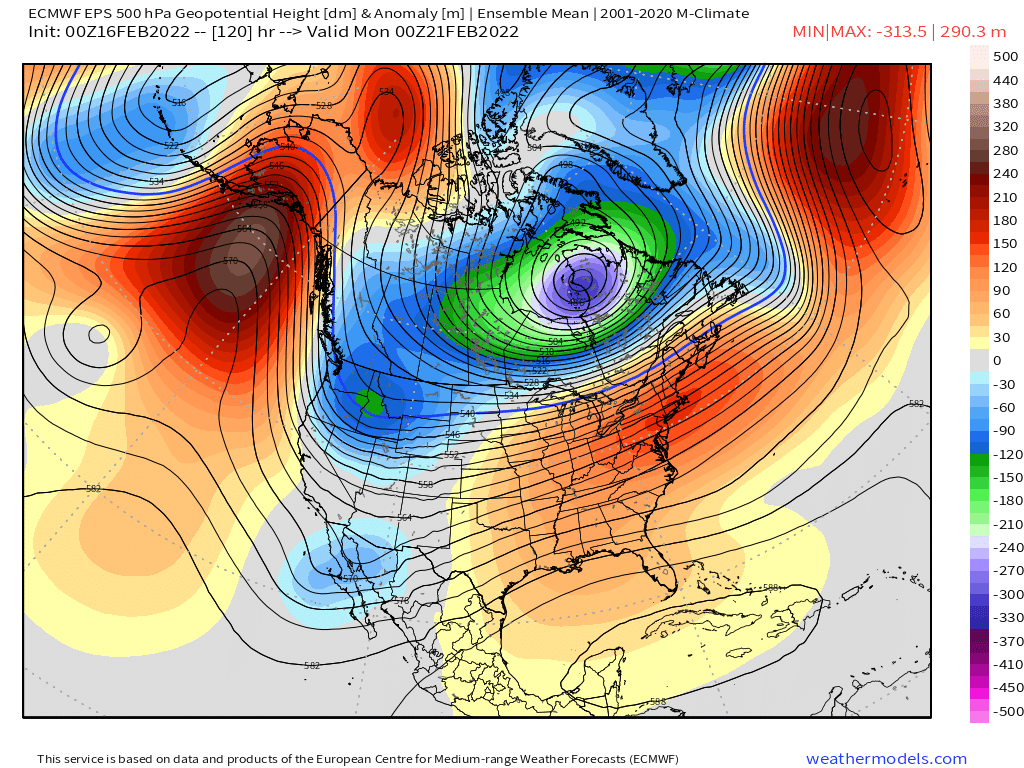
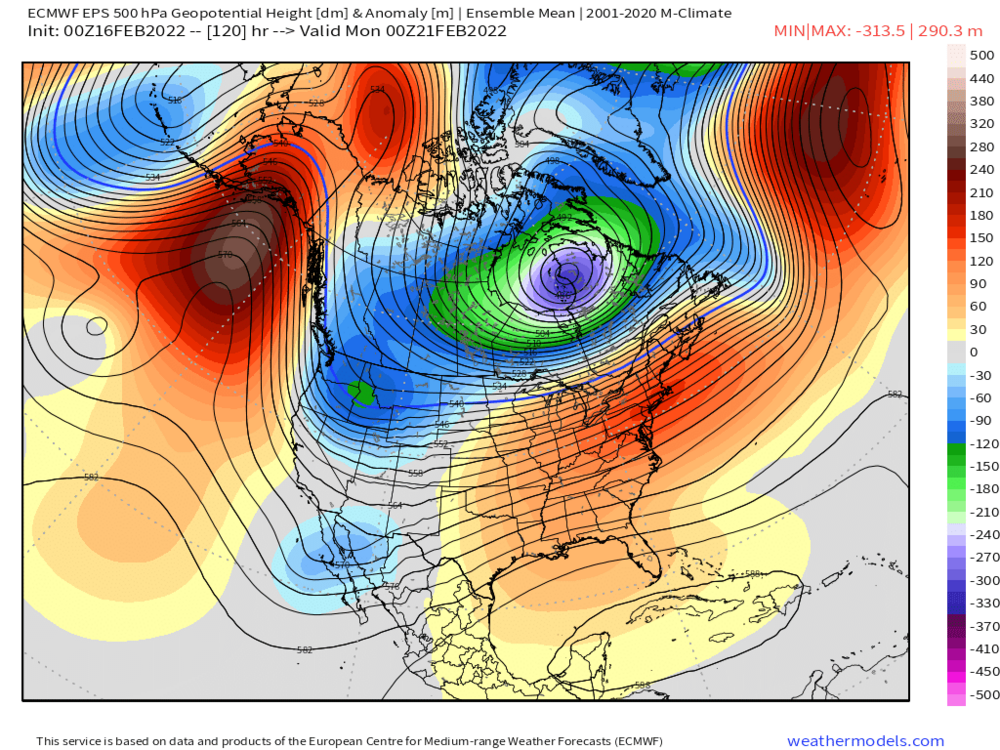
Yeah and this is a good reason to be skeptical of the MJO RMM charts too (Scott- coastal_wx has often made this point)....they are often incorrect anyway, but even when they technically are correct, they may not be driving the pattern. It was a while back, but I also remember something similar happening in 2013 as well...everyone was going full blown torch for late Feb 2013 into March because of tropical forcing forecasts and those ended up being a huge bust. That type of anomalous cyclone you showed can also transfer a good amount heat into the upper troposphere of the arctic, so that will only help fuel any EPO blocking.
-
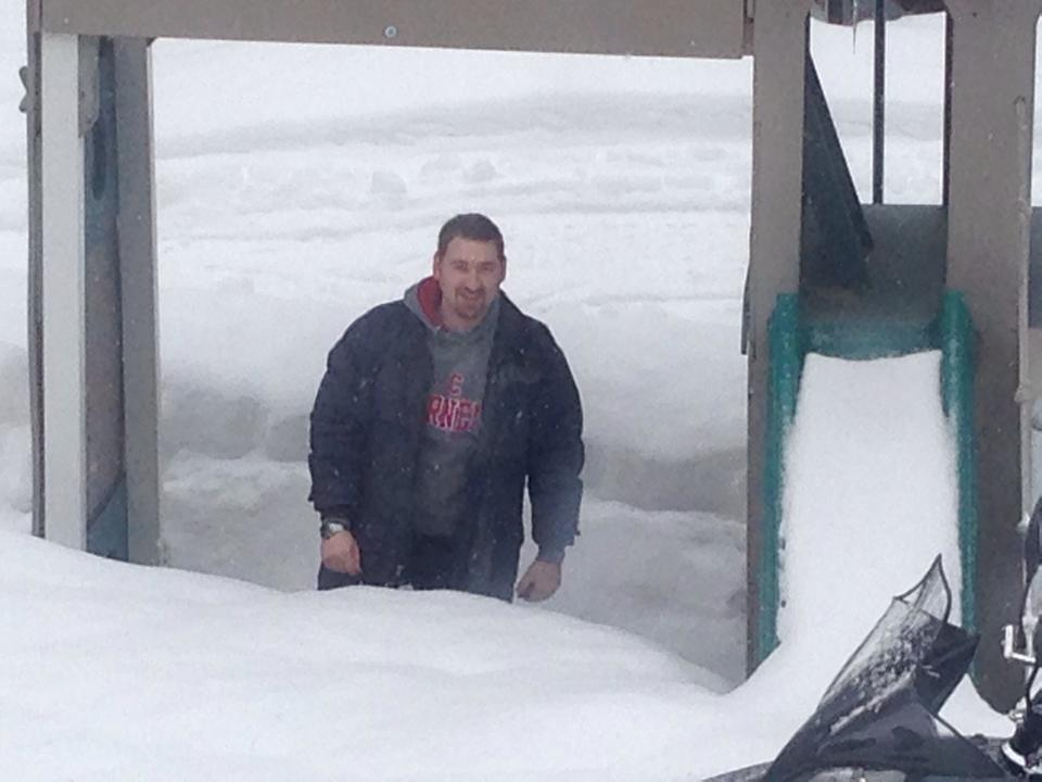
Yeah I found about 60" on the level up around the top of North Peak (just below in the woods)...probably was even higher in the woods of Oz/Aurora/Jordan. Even down at the base most spots had over 40". This was me actually at the old Evergreen Valley Inn about 25 minutes south of SR on that same trip. Even there in Stoneham, you can see it was about 3 feet on the level. Maybe a bit more in spots. There were a million snow mobilers there that year (you can even see part of a snow mobile in the foreground)
-
I agree that next week is definitely vulnerable to a southward push of the boundary....moreso than this week was. The meridional flow out of the northwest territories/Yukon is much more pronounced next week than this week is, so there is definitely room to see model guidance push the sfc boundary further south. It's already pushed south a decent amount from progs 2 days ago.....we'll have to see if that continues. There;s actually some weak Greenland ridging too early next week....it's not the driver, but it doesn't hurt. But you can see how much the flow out of NW Canada will want to press arctic cold south
-
That storm was really the line for where the month was good and where it wasn't. There was like a solid 8-12" in that storm where you got into the steady stuff. The gradient was insane....like from 8" to almost nothing within 5-10 miles.
-
March 2015 sucked ass for everyone not within 20 miles of the coast. Still, at least if it was going to be cold with little new snowfall, we had a monster pack to make it look nice. Mar 2014 was way worse....frigid but our pack got mostly wiped out by the 3/13/14 storm which was great for NNE. I did go up to Sunday River that month in 2014 and it was epic.
-
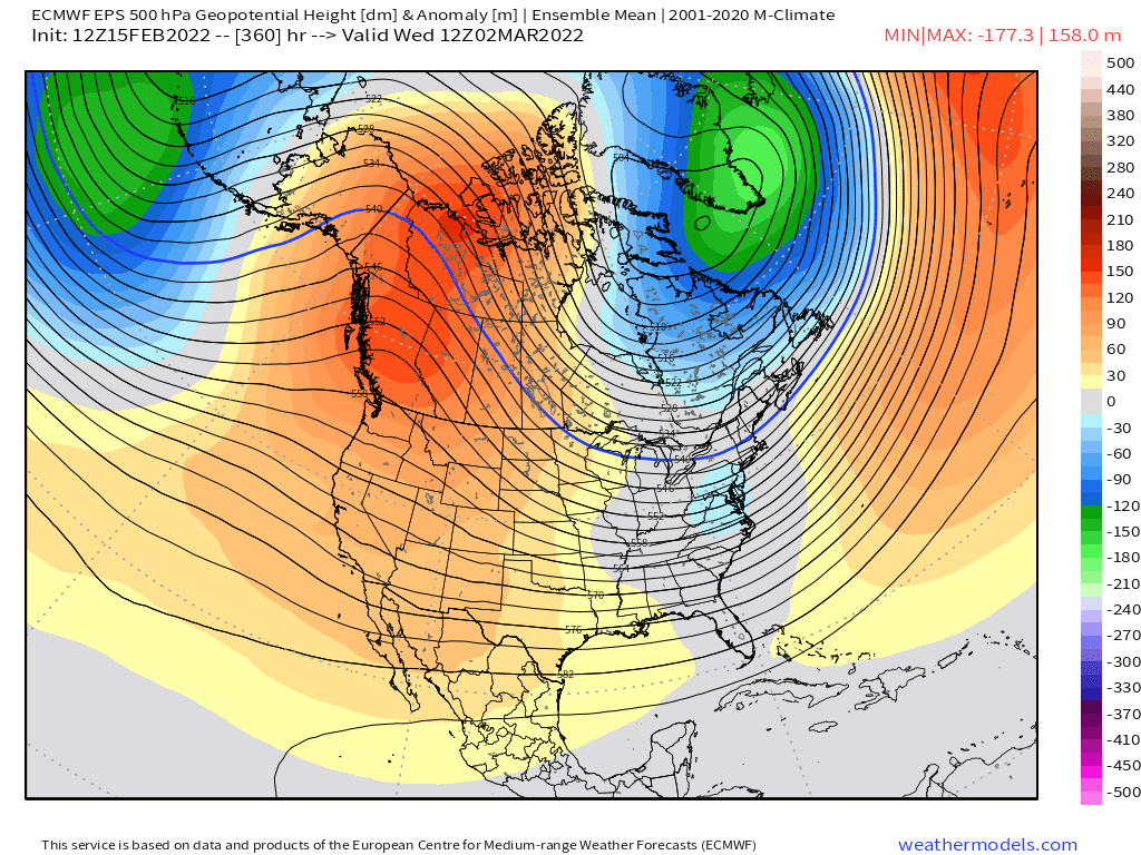
It probably won't be extreme...but even if that verifies diluted by 30%, it's still a pretty cold/stormy look. Then again, it's not uncommon for a signal that strong at D12-15 to morph into a extreme pattern.
-
Yeah you can see toward the end of the run, the PNA ridge and EPO are linked which creates a very meridional pattern that even loses the SE ridge....so perhaps a chance at a season-end big dog with that look if it verifies.

-
The PAC supports that...huge EPO block north of AK with a +PNA
-
Yeah true...lol....GEFS has been largely better than the EPS for the past 6-8 weeks. EPS did catch this mid-Feb warmup better IMHO, but outside of that, it's not been its usual dominant self (echoing our criticism of the OP run this winter)
-
Had a couple of cutters in there (or pseudo-cutters like the 1/17 BGM storm) that kind of took the shine off that period despite the objectively good snow total between 1/7 and 2/14. I did basically have full snow cover since 1/7 though until the 3 days ago when it became patchy before being covered again 2/13....but there were many days it was just a thin icy glacier. Not a true deep winter feel. Still, beats the hell out of December or any period from winter 2019-2020.
-
That shortwave has been steadily trending south
-
I was commuting into Boston that year for work on the seaport....I remember the harbor finally froze over during the 2/2/15 storm and it didn't unfreeze until around 3/20....pretty insane that it was completely frozen over for like 6 weeks. In addition, all the snow out on the harbor ice was blown and drifted into various mounds and sculptures and you'd get random ground blizzards out there on sunny days in late February because the snow was staying powdery and couldn't get soft and refreeze due the lack of warmups. Looked more like some city on the arctic ocean rather than a temperate climate.
-
BOS was robbed of futility 10 days later too....they got like 9 or 10 inches in the 3/16-17 storm when they were sitting on like 7 or 8 inches for the season before that.
-
Western MA has had a horrific winter....could be top 5 worst out there, though still some time left to turn it into just a mundane turd rather than historic.
-
When you look at the map of that outbreak, that's how to get it done late in the year. You want that delivery being drilled in from the NNW minimizing any chance of modifying at lower latitudes.
-
Yeah this year has had a dearth of advisory type events. Part of the reason the interior is taking it on the chin. Even a place like Boston usually needs more than a few events to have 40"+, but getting a 2 footer helps.