

ORH_wxman
-
Posts
93,095 -
Joined
-
Last visited
Content Type
Profiles
Blogs
Forums
American Weather
Media Demo
Store
Gallery
Everything posted by ORH_wxman
-
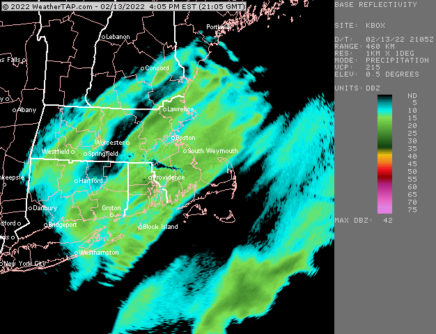
Some nice bands filling in
-
Classic sun angle obs….driveway has become snow covered again now that it’s late afternoon. Accumulations becoming more efficient again.
-
You’ll play catch-up tonight.
-
For what? For an additional 3-4”? Prob anyone from near a BOS to Ginxy line and southeast…NW of that looks a little lighter. Maybe another inch or two. I do think the best shot for something over 4” tonight is down in SE MA closer to Plymouth county and maybe over toward RI.
-
The IVT is the wildcard. There could be an enhanced area of heavier snow where the best LL convergence zone sets up. You never know how these go but an additional 4-6” for someone who gets under it isn’t out of the question at all.
-
Yeah shoveled the steep part of the driveway earlier and it’s bare pavement now. Tip’s solar spring doing the dirty work.
-
Got about 3” so far. Hoping for another 2-3” tonight. Best goods will be SE of here tonight though.
-
The fronto band tries to regenerate a little bit later this morning/midday but further east than it was this morning.
-
This is definitely jspin hairdryer blower fluff. If this evening has the same type of snow growth, I wouldn’t be shocked if there’s a lot of 6”+ amounts (esp SE MA) on like a quarter to third inch of liquid equivalent.
-
Because it will be 50 degrees and raining?
-
HRRR hits RI really hard and parts of SE MA. Even back where I am it’s solid advisory.
-
Paste would get annihilated in that too unless it was like 12”+
-
I hope they delay the change until they can figure out what’s going on with it.
-
SE MA prob gonna get warning snows when you add in the IVT later on. Maybe RI too.
-
Already gave my thoughts…might change based on 00z…but sticking with 1-2” maybe 3” for interior…best chance for advisory or better in SE MA
-
18z euro bumped NW. A little more defined with the IVT in SE MA too. That’s gonna have to be watched down there for a larger positive bust.
-
RGEM not biting on the NAM solutions is a bit of a red flag to me. It should be catching onto this inside of 24h. I’m not buying NAM yet. I’ll give it until the 00z run but for now I’m sticking with 1-2” here maybe a 3” lolli. Down there it could be advisory snows.
-
If northern stream was able to capture it would be a really big system. Double digits…but oh well…I’d be ecstatic if even something like the NAM verified.
-
Good cross hair sig on some of these soundings too.
-
Lol 18z NAM gives warning snow to parts of ORH county just from that band.
-
I’d watch to see if those higher amounts in the fronto band start translating further NE as we get closer to game time. Already sort of seeing it some.
-
18z NAM getting interesting.
-
Ukie bumped NW again too.
-
GFS was good for SE MA
-
Its important to get that 1” on the roads.


