

ORH_wxman
-
Posts
93,095 -
Joined
-
Last visited
Content Type
Profiles
Blogs
Forums
American Weather
Media Demo
Store
Gallery
Everything posted by ORH_wxman
-
It would take a special set of circumstances for me not to root for a snow event. I’m not a jackpot fetishest or even a big dog elitist. I’ll take the 2” snowfall.
-
Reggie got better....but it had nothing at 12z....now it has that fronto band trying to give a couple inches to eastern folks.
-
It is shocking news....but the 18z ICON will not be repeating the warning event that the 12z run showed for eastern areas.
-
Yeah...basically poison pill is any "Caveat" to a better trend...like "the southern stream got better but the northern stream pressed more so it still sucked" or "both the northern stream and southern stream got better but a previous unidentified scooter shitstreak appeared in Quebec just in the nick of time to suppress the best forcing out to sea".
-
Always keeping us sucked in. Not biting until Euro or GFS shows a definitive move that isn’t accompanied by some poison pill.
-
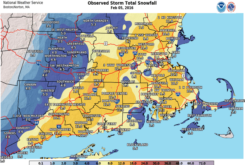
I think you are referring to the Jan 2016 blizzard that crushed the mid-atlantic....2/5/16 was a short term bust that came roaring back in the final 48 hours to give a lot of SNE warning snowfall with 9-12" in eastern MA/RI.
-
It's pretty clear you aren't recovering to a respectable season there (and maybe not here either), but I'm still rooting for good storms. The alternative is dogshit this time of the year. Really untl at least mid/late April...sometimes longer.
-
Yeah it's been one of those seasons....but I've learned over the years not to let past failed storms cloud the judgement on a new threat unless there is a good reason to compare them. Sometimes you'll get the coup out of nowhere even in a bad season (2/5/16 comes to mind)....but this one is running out of time quickly for sure and I'd probably close the shades in western areas too. Even out east it's running out of rope quickly. Hopefully we can score a bomb as the wavelengths shorten.
-
EPS still saying at least SE areas should still monitor this....it's about time to write off a bigger solution though. At the very least we'd need to see a pretty big shift by 00z tonight to start thinking anything higher-end again (double digit snowfall). It's too bad because we've managed to trend the northern stream into a decent position but the southern vort went to crap and keeps the flow too broad/rounded.
-
Yeah departures in spring are mostly driven by onshore flow/diabatics...esp once past the first couple weeks (we can still get solid cold from deep layer advection in late March/early Apr but it loses it's punch really quick after that)
-
Definitely a bit better but it's not enough for most....this is going to be a classic fronto band for SE MA where they get 8" of fluff and the rest of us are scraps.
-
This is a classic setup for Tblizz bitches his way to 8" in a fronto band while the rest of us get whiffed or 1-2" sand.
-
Northern stream was better on GFS but southern stream was worse
-
Reggie wasn't a big help....but we've seen NAM and ICON trend significantly better. Kind of annoyed that Reggie did not trend better aloft like the other two did, but we'll see what the varsity models say soon.
-
What is Tblizz doing this morning?...time to confiscate the edibles from him.
-
Slow is good too in this case....we want the whole trough to slow down and give us time to let that northern stream turn the flow more S to N on the eastern side of the trough...
-
Yep, if we get this type of trend on the rest of the 12z suite, then we have a pulse still.
-
It's like RAAAAAAAAAIINNNNN.........on your KU day It's the Greenland bloooooock, when it's already May, It's Tip's hadley celllll, with an big RNA..... And Ray smokes exhaust....it figures
-
Yeah there will likely be a fronto band with this thing…SE areas favored for now. But unless we get back to sharpening up that southern stream again, the upside is something like 4-7” in a stripe. For the higher end scenarios to be back in play, we’ll want to see a big trend at 12z of sharpening up the southern vort and having it phase with northern stream. I’m not expecting that trend, but it’s what we would need.
-
This one needs a big trend at 12z or it’s done.
-
Nice move but still need another going forward. It would be nice if we could sharpen up that southern stream just a tad more. The northern stream is in pretty good position this run.
-
GFS coming in better than 18z
-
Northern stream was way west but the base of the front runner is pretty rounded. I do think that would eventually go boom though…too far west not to.
-
Would like to see the trend continue on 00z obviously. It would be nice to see either the GFS or Euro have a hit.
-
Yeah slight improvement on 18z euro.


