

ORH_wxman
-
Posts
93,095 -
Joined
-
Last visited
Content Type
Profiles
Blogs
Forums
American Weather
Media Demo
Store
Gallery
Everything posted by ORH_wxman
-
There will definitely be two jackpots in this one. First one will be under the fronto band and the second will be in SE MA probably from the IVT stuff.
-
12zNAM coming in just a smidge better again.
-
It’s initially a pretty defined fronto band but then as the event drags on, it’s more an IVT in SE MA and that’s where advisory amounts would be most likely.
-
06z euro looked a little better again. Maybe 1-2” for a good chunk of SNE with some 3-4” amounts in far SE MA. Gonna have to watch for dry air on northern edge.
-
Yeah I’d take it in a heartbeat but unfortunately it will cave in the next run or two once all the varsity models have had their turn showing how out to lunch it is.
-
Icon is tossed. Nothing else is remotely supporting it. Best chance of advisory snows is a narrow stripe from the little fronto band models have.
-
Yes that 2/8 storm was a disappointment. Some model runs were trying to give a lot more but we ended up getting too much shortwave interference inside of 48 hours and it turned into a mundane moderate event….the 2/5 event was much better.
-
Yeah it’s doable. The issue is you have to avoid the trend back east too when this close in. But if we can grab another couple 20 mile jogs NW, it gets a lot more interesting.
-
For Jerry....this was less than 48 hours before the 2/5/16 event: http://www.meteo.psu.edu/fxg1/ARC/2016/20160203/WRF_18z/namloop.html http://www.meteo.psu.edu/fxg1/ARC/2016/20160203/AVN_18z/avnloop.html Prob one of the worst we've seen in recent years for that short of a lead time. Almost certainly not gonna happen this time, but another small nudge could make it a respectable advisory event and maybe something a little more for far SE areas.
-
ICON and Reggie both came NW too....ICON trying to give SE MA a legit snowstorm again....lol. So pretty clear trend on the 18z JV models....lets see if the varsity team is game.
-
Probably not, but we obviously did it 6 years ago....lol. It really doesn't need to move that much to give BOS-PVD and SE areas a solid 4-7" type event. But the bigger issue is when you are this close to the event, you cannot afford any setbacks. If 00z just tickles back SE, then it's a nothing-burger or nuisance event.....or even the other 18z guidance if it doesn't tick NW like the NAM did.
-
I haven't had a good winter. Not as bad as you, but it's been solidly below normal for snowfall. If you lopped 6" off my 1/29 total, it wouldn't really change my perception much.
-
Lots of whining these days. But whatever....I'll take whatever snow I can get. I try to tune out the whining.
-
Happy hour NAM is actually pretty decent for CT over to SE MA...maybe 2-4" amounts in a stripe. Maybe even approaching 5-6" in SE MA.
-
ATL blocking looks dead to me....maybe it comes back in March....but I'm not counting on it. That said, we can still get plenty of overrunning events without ATL blocking. Essentially all of 2007-2008 had no blocking and ditto 1993-1994. '93-'94 had a great pacific though...'07-'08 was a little more muddled but we had great timing on so many events to keep the highs to our north.
-
Hopefully we can grab another 56F on the 3-4th of July again like last year.
-
Yeah the interior is having a sneaky bad year....even a place like ORH who got nearly 15" in the blizzard and even got a pair of 6" events (1/7 mesoband and the 1/17 BGM storm front-ended them) before the blizzard....is taking it on the chin this winter. They are like 12" below normal now on the season and the deficit is only going to grow over the next week.
-
Yeah when I started seeing the -PNA/-NAO pattern setting up on guidance, I was starting to think big things for the month, but it ended up being a harbinger of how this season has gone. Always something unforeseen and anomalous to screw up an otherwise great setup....whether its a double boob low turning a Feb '13 into an E MA CJ or having the -PNA decide to dig far enough south for Cabo San Lucas to freeze their balls off.
-
Yeah we could still get one...but I'm just surprised we haven't had them already this season. As I discussed with Ray earlier, we had a pretty good longwave pattern for them in December, but the -PNA just went a little too extreme on us. Like if that was "merely" -2 sigma instead of like -4 sigma, we probably clean up.
-
Yeah for sure...if that RNA was just a little less extreme...we likely would have had multiple events like that (we went over how similar that pattern was to Dec 1970...just the RNA was more extreme)....you saw how many went through the meatgrinder as they were approaching us. Not only does a lesser RNA relax some of that meatgrinder, it also allows the cold to seep a little further south....potent combo...highs pressing down a little more against stronger shortwaves that don't lose their integrity.
-
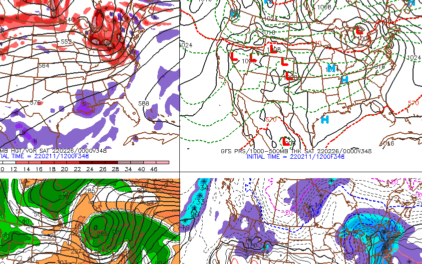
I just happened to scroll through clown range on the GFS today....and this event caught my eye not because it's remotely going to happen, but because it's the type of event I would have expected more of this season but we just haven't seen them. We usually have at least 1 or 2 during a La Nina. Even cruddy La Ninas usually feature one. Can't remember the last time we had a solid front end thump on a nice SWFE...maybe 2/12/19.
-
I'd actually be surprised if you don't see at least a 1-2" snowfall...with a chance for advisory amounts down there. Back here, I'm thinking probably a C-1" type deal, but can't rule out a 2-3 incher yet if we bring this back west ever so slightly which is certainly still possible.
-
EPSis back to a furnace to end February. But it’s been showing that off and on for weeks and it never seems to verify. But might be a little more plausible this time…they still disagree though with GEFS over what’s happening in the EPO region.
-
You’re not forecasting 6” of snow there?
-
At least the car seats will feel warm in the parking lot with the -20C airmass behind it.


