ORH_wxman
-
Posts
93,095 -
Joined
-
Last visited
Content Type
Profiles
Blogs
Forums
American Weather
Media Demo
Store
Gallery
Everything posted by ORH_wxman
-
Winter storm for the 25th of February is imminent.
ORH_wxman replied to Typhoon Tip's topic in New England
Nice jackpot for Ray on Ukie....good spot up there for this one....far enough south to get in on the bent back WF slowing down but far enough north to probably avoid sleet....or any sleet of consequence....a couple hours of 15 dbz sleet when you're dryslotting at the end of the thump doesn't really matter. My gut still says the NH border region is the jackpot area, but pike region should still clean up nicely. I'm expecting a little bump north on the best features and QPF max zone. Even runs like the GEM, GFS and Ukie are tracking that vort over like BUF-ALB axis. That's not obviously the end-all-be-all....the WAA is going to get major resistance from that airmass....but you still have to think the laws of mid-levels are going to eventually square with that. You'll get a prolonged deeper saturation up closer to that track in S NH. -
Winter storm for the 25th of February is imminent.
ORH_wxman replied to Typhoon Tip's topic in New England
Yeah I remember being initially skeptical of 12"+ amounts in 2/5/14 but we were discussing the bent back WF and how it was just going nuts on the north side of it...and then it verified that morning. We were getting like 2-3" per hour rates even with snow growth not that great. Like a quasi-stationary band near the pike in that and maybe 10-20 miles either side. The QPF was big....BOS and ORH ASOS both had over an inch of QPF in that. Not saying we can lock that in yet on this one, but if the model guidance doesn't change significantly, then it's going to happen somewhere in a 20-30 mile wide zone. -
Winter storm for the 25th of February is imminent.
ORH_wxman replied to Typhoon Tip's topic in New England
Very nice looking bent back WF in the mid-levels on these runs. That is indicative of a very strong thump. Same sig as 2/5/14....that's how you can manage 10-12" of dense snow from these. You want to be just north of that mid-level WF where it's slowing down to prolong the enhancement. -
Winter storm for the 25th of February is imminent.
ORH_wxman replied to Typhoon Tip's topic in New England
Yeah the NAM could be right with the further north vort track...if it is, then other guidance will start bringing the sleet further north. But if it's wrong on the vort, it will be wrong on the thermals. -
Winter storm for the 25th of February is imminent.
ORH_wxman replied to Typhoon Tip's topic in New England
This will end up well south of 2/4....even the chickens struggled to snow much in that one. -
Winter storm for the 25th of February is imminent.
ORH_wxman replied to Typhoon Tip's topic in New England
Just watch the vort track....if you track it over Toronto, it's going to be a warmer profile than if you are tracking it over BUF to BGM. -
Winter storm for the 25th of February is imminent.
ORH_wxman replied to Typhoon Tip's topic in New England
The dense airmass in place is going to help focus a lot of heavy lift over SNE even if we get sleet up to NH border area…so I think I’d probably be going warning snowfall amounts here unless we start getting this vort tracking north of Lake Ontario into Ottawa and start pelting the chickens. But I’m also a little bit skeptical of a very far north vort track for the same reason. Lot of confluence up there. This is a pretty ideal location for high pressure. Classic scooter high. -
Winter storm for the 25th of February is imminent.
ORH_wxman replied to Typhoon Tip's topic in New England
06zNAM might be right but it’s synoptically different than other guidance with how far north the vort is. If other guidance gets that vort tracking into Toronto then they will bring sleet up to S NH too. It’s not a situation where they are tracking things the same but NAM is just blasting ML warmth further north. -
Winter storm for the 25th of February is imminent.
ORH_wxman replied to Typhoon Tip's topic in New England
Yeah I could see 6-10” over the MA/CT border while you get 3-4” of snow and pellets. Certainly still on the table. -
Winter storm for the 25th of February is imminent.
ORH_wxman replied to Typhoon Tip's topic in New England
That NAM run is pretty far north with the vort too. Tracks it up into Lake Ontario and Toronto. A lot of other guidance is more like Erie PA to BGM to MHT which would keep the sleet line probably near or south of the pike. -
Winter storm for the 25th of February is imminent.
ORH_wxman replied to Typhoon Tip's topic in New England
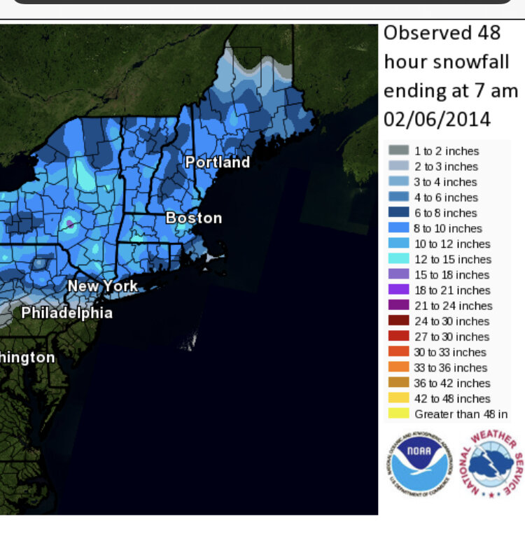
Here’s a map from that storm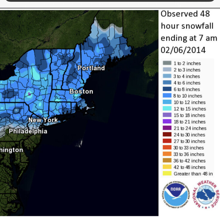
-
Winter storm for the 25th of February is imminent.
ORH_wxman replied to Typhoon Tip's topic in New England
Except for the times it isn’t. Sometimes it’s closer to MA/CT border (like 12/16/07) or sometimes it’s more like HFD-PVD line where the sleet stalls (like 12/13/07 or 2/5/14) and others it’s the pike and others it’s MHT-PSM (12/3/07?) This one looks like it might be near the pike but it could be more near you too. Or up by rt 2. 2/5/14 is a pretty good looking analog right now. 1/28/09 is a decent analog too but I don’t like how that one had the high sliding east. Both this event and the 2/5/14 event have the high in a very good spot not sliding east so it may be tougher to trend the sleet well north up into MHT or CON. -
Weeklies are below normal through the equinox. They do have a brief break between about 3/3 and 3/7 or so kind of like the EPS do, but it reloads quickly.
-
Winter storm for the 25th of February is imminent.
ORH_wxman replied to Typhoon Tip's topic in New England
A couple years ago, we were actually making fun of a peer reviewed paper that showed snow climo going to like 40-50% of normal for places like ORH and PWM by 2040. I always wondered how those pass the smell test. I’m pretty open-minded, but ORH averaging 30” of snow in less than 2 decades is a hard one to square. I mean, we routinely clear that by 1-2 feet even in +3 or +4 temp departure winters. -
Winter storm for the 25th of February is imminent.
ORH_wxman replied to Typhoon Tip's topic in New England
I just caught up on the 12z runs as I was out all morning away from internet. The trend seemed to be a subtle shift south on the 12z guidance. GFS did bump north a bit but all the foreign models came a little south so the overall suite was a little colder/south than 00z. I still think this comes back a little north at some point down the stretch. The question is whether it sags a little south first before that happens. I’m also finding myself agreeing with Tip that the overall tenor of this system really hasn’t changed much at all in the past 48 hours. GFS made its usual moves but the rest of guidance hasn’t been all over the map that much. Esp when you concede that we’ve been tracking this since 200 hours out. -
Yeah that’s the type of look that can turn into a coastal. There was a run or two that actually got us with something on the euro for that event. GFS today was a scraper. Something to watch for after the 2/25 threat.
-
Winter storm for the 25th of February is imminent.
ORH_wxman replied to Typhoon Tip's topic in New England
Depends how deep the omega is on these. Sometimes you get monster omega punching up into 500mb and you get good snow growth anyway (ala 12/16/07) but most of the time these have crappier snowgrowth. It’ll be heavy baking powder for several hours which is good for base building but not great for maximizing accumulations. This could also trend another 75-100 miles north so that most of SNE ends up with 2-4” before the flip…that’s another possibility. -
Winter storm for the 25th of February is imminent.
ORH_wxman replied to Typhoon Tip's topic in New England
My guess is sleet will def make it to at least the MA/NH border. You aren’t tracking that vort through central NY and keeping sleet line south of the pike. That doesn’t mean no big thump before that though. The thump looks very strong right now on most guidance. -
The GYX to ORH axis (including Rays area) has taken it on the chin this winter. Kind of due for a few snow bombs that hit 15+ miles inland.
-
Winter storm for the 25th of February is imminent.
ORH_wxman replied to Typhoon Tip's topic in New England
It did this in the Feb 4th system. It eventually caved at lest partway. -
Sorry to hear my friend. Hopefully the new place is good to you. Maybe we can get one more big dog before this season is over.
-
Winter storm for the 25th of February is imminent.
ORH_wxman replied to Typhoon Tip's topic in New England
You proudly flaunt your IPA affinity. Nothing wrong with that or the edibles. I don’t personally care, lol. I just noticed you were making more and more posts about it recently. Though the “Friday is gone” post did cause some of us to be concerned maybe you had consumed 3 or 4 IPAs instead of the usual one or two before passing out. -
Winter storm for the 25th of February is imminent.
ORH_wxman replied to Typhoon Tip's topic in New England
Yeah I’m selling GFS. This pattern wants to track the vort well west and typically that is going to hint where the trends will happen. Even the GFS is tracking the vort from about Erie PA to CNE. That’s not typically going to stay all snow south of the pike. -
Winter storm for the 25th of February is imminent.
ORH_wxman replied to Typhoon Tip's topic in New England
You are becoming obsessed with his weed usage. It’s prob 10x healthier than beer. -
Luckily for the ski areas, the pattern setting up after Wednesday’s torch is one where NNE can rebuild some base and maintain it. It will be a cold pattern…not one of those “we got 6” of feathers and it was 38 degrees and sunny two days later so it all evaporated” type patterns. I’d honestly be kind of surprised if NNE doesn’t clean up the next 3 weeks based on ensemble guidance. Of course, this winter has found ways to disappoint so a screw job wouldn’t be a total shock but it would still be something that’s low probability to me. Esp up there.