

ORH_wxman
-
Posts
93,092 -
Joined
-
Last visited
Content Type
Profiles
Blogs
Forums
American Weather
Media Demo
Store
Gallery
Everything posted by ORH_wxman
-
Winter storm for the 25th of February is imminent.
ORH_wxman replied to Typhoon Tip's topic in New England
It is still tracking the vort north of the Euro and some other guidance....the 12z run is tracking it over northern Lake Ontario. While others are more like BUF to ROC . It's not a massive difference but that 25-30 miles matters when we're talking about areas that are flirting with the sleet line. -
Winter storm for the 25th of February is imminent.
ORH_wxman replied to Typhoon Tip's topic in New England
We didn't get more snow along the pike than 06z because the QPF was pretty weak sauce this run compared to previous. QPF is under an inch for us through 21z tomorrow on the 12z run. -
Winter storm for the 25th of February is imminent.
ORH_wxman replied to Typhoon Tip's topic in New England
Def colder than 06z though...06z gave almost no snow south of HFD, now the 12z gives advisory snows down there. -
Winter storm for the 25th of February is imminent.
ORH_wxman replied to Typhoon Tip's topic in New England
12z NAM tickling colder through 21 hours. Heavy snow down in parts of S CT at 09z while the previous run was scalping them. -
Winter storm for the 25th of February is imminent.
ORH_wxman replied to Typhoon Tip's topic in New England
Yeah the CF will def be most pronounced in SE NH or S ME....but that isn't the only factor in the best snowfall...you want to overlap that with the strongest fronto banding....the fronto banding is a little stronger south and it weakens some as it goes north into S ME. So I'm picking your area to S NH to get the best of both worlds (longest exposure to good fronto banding while getting CF enhancement at the same time) -
Winter storm for the 25th of February is imminent.
ORH_wxman replied to Typhoon Tip's topic in New England
There will be 12"+ totals....this is not skimpy on QPF. Most likely spot is prob S NH/S VT and N MA near the border and maybe into far S ME where they get into quasi-stationary banding for a while while those of us to the south are dryslotted for a time. -
Winter storm for the 25th of February is imminent.
ORH_wxman replied to Typhoon Tip's topic in New England
HRRR looks a little colder than 06z through 24 hours -
Winter storm for the 25th of February is imminent.
ORH_wxman replied to Typhoon Tip's topic in New England
Almost every model has it mostly done by 18z unless you are up by Ray…then round 2 starts sinking south and filling in late afternoon. -
Winter storm for the 25th of February is imminent.
ORH_wxman replied to Typhoon Tip's topic in New England
06z euro is prob in the middle of guidance right now. NAM is still the warmest by a decent amount though the gap isn’t nearly as much as 12z yesterday when it was actually failing to give Ray warning snows. -
Winter storm for the 25th of February is imminent.
ORH_wxman replied to Typhoon Tip's topic in New England
Clearly no coordination between ALY and BOX since one office tossed the NAM and the other is buying it. -
Winter storm for the 25th of February is imminent.
ORH_wxman replied to Typhoon Tip's topic in New England
Btw, I watched him too. Amazing how much energy he still has. You can tell he still gets excited for these higher impact snow events. Lol. Hopefully he goes another couple winters before hanging them up…all time great. First ballot HOFer. -
Winter storm for the 25th of February is imminent.
ORH_wxman replied to Typhoon Tip's topic in New England
He will probably peak at the 00z NAM to make sure it comes south a little more and then update the map for the 11pm segment. -
Winter storm for the 25th of February is imminent.
ORH_wxman replied to Typhoon Tip's topic in New England
It’s because they don’t forecast for NH. They are using the GYX forecast for the NH amounts. I would assume they coordinate more with GYX on the border region before they issue a more final map. -
Winter storm for the 25th of February is imminent.
ORH_wxman replied to Typhoon Tip's topic in New England
IJD is a bit of a snow hole because warm air from the south gets in there unimpeded and it can get a bit of downsloping on an east or northeast wind. It’s not the worst spot in CT but usually most of the towns to your north/northeast/west will do better. I remember the storm you are talking about though last year…I think it was the super bowl Sunday storm on 2/7/21. That awesome band smoked your area. -
Winter storm for the 25th of February is imminent.
ORH_wxman replied to Typhoon Tip's topic in New England
Just need some pics of your kids playing in 12”+ Friday evening while puffy 30 to 1 CJ dendrites fall on a light northeast wind as you are snow blowing the driveway. -
Winter storm for the 25th of February is imminent.
ORH_wxman replied to Typhoon Tip's topic in New England
In all seriousness, you at least aren’t gonna get screwed in this one. Jackpot or not….you’re a lock for 8-12” with some upside for 12-16 if you can get into that quasi-stationary banding Friday morning/midday. -
Winter storm for the 25th of February is imminent.
ORH_wxman replied to Typhoon Tip's topic in New England
He’ll get like 9-10” with round 1 and then the evening CJ/IVT will give him another 3” of currier and Ives jspin fluff and it will allow him to beat Ray by 0.2” and then Ray will have a huge meltdown. -
Winter storm for the 25th of February is imminent.
ORH_wxman replied to Typhoon Tip's topic in New England
Looks slightly colder than 12z. But almost the same. Noise. -
Yeah it would favor those type of threats. Cutters are a definite risk too.
-
Winter storm for the 25th of February is imminent.
ORH_wxman replied to Typhoon Tip's topic in New England
Yeah I wouldn't change any forecasts yet unless I was on the low side already....if 00z comes in similar to these non-NAM solutions, then I'm probably going to up my expectation to like 8-14" for the pike region. Right now, I'm kind of thinking more like 5-10. -
Winter storm for the 25th of February is imminent.
ORH_wxman replied to Typhoon Tip's topic in New England
18z Deutschmark went south/colder too to round out the JV suite. -
Winter storm for the 25th of February is imminent.
ORH_wxman replied to Typhoon Tip's topic in New England
This is the furthest north that run gets with the sleet line....I'm skeptical but that's kind of like the Euro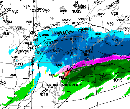
-
Winter storm for the 25th of February is imminent.
ORH_wxman replied to Typhoon Tip's topic in New England
18z Reggie went another tick colder. Here's 12z Friday: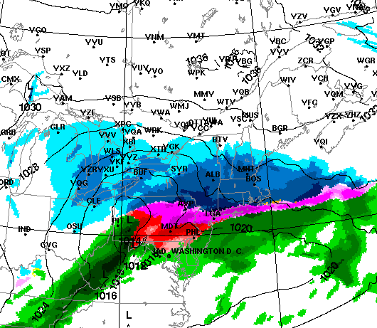
-
Winter storm for the 25th of February is imminent.
ORH_wxman replied to Typhoon Tip's topic in New England
I wouldn't be surprised if the NAM comes south at 00z and the other guidance comes north to narrow the goalposts. Other guidance is so much colder/south than the NAM that at some point we're going to need to see a convergence. -
Winter storm for the 25th of February is imminent.
ORH_wxman replied to Typhoon Tip's topic in New England
Yeah it went south and is still the warmest....tells you how much of an outlier it was at 12z. I'll bet it comes south again at 00z.


